
Introduction
Every successful construction project begins with understanding the ground beneath it. No matter how strong a bridge, highway, building, or retaining wall appears on paper, its long-term performance depends on the strength and behavior of the supporting soil and rock. This is where a geotechnical report becomes essential.
If you have ever wondered, “What is Geotechnical Report?”, the answer extends far beyond a collection of soil test results. A geotechnical report serves as a technical document that explains the subsurface conditions of a project site and provides engineering recommendations for safe, economical, and durable construction. Civil engineers, highway engineers, architects, contractors, and project owners rely on this report to make informed design and construction decisions.
In road engineering, a geotechnical report helps determine pavement thickness, embankment stability, drainage requirements, and suitable foundation solutions. Without accurate geotechnical information, projects may experience settlement, pavement cracking, slope failures, excessive maintenance costs, and structural damage.
This guide explains What is Geotechnical Report? in simple engineering language while covering its objectives, components, field investigations, practical applications, and industry best practices.
What is Geotechnical Report?
A geotechnical report is a detailed engineering document that presents the results of subsurface investigations and laboratory testing carried out at a construction site. It describes the engineering properties of soil, rock, and groundwater and provides recommendations for designing safe foundations, pavements, embankments, retaining structures, and drainage systems.
The report acts as a bridge between field investigations and structural design. Instead of making assumptions about underground conditions, engineers use verified data to select suitable construction methods and materials.
For example, before constructing a highway, engineers need to know whether the subgrade consists of dense gravel, soft clay, loose sand, or weathered rock. Each material behaves differently under traffic loads, making the geotechnical report an essential part of the design process.
Simple Definition
A geotechnical report explains what exists below the ground surface and how those conditions affect engineering design and construction.
Why is a Geotechnical Report Important?
Many construction failures originate below ground rather than above it. Weak soil, high groundwater levels, or unstable slopes can create serious problems if engineers do not identify them during the planning stage.
A geotechnical report helps reduce uncertainty by providing reliable site-specific information.
Key Benefits
- Improves structural safety.
- Supports economical foundation design.
- Reduces construction risks.
- Minimizes unexpected site conditions.
- Helps estimate project costs accurately.
- Prevents excessive settlement.
- Increases pavement service life.
- Supports effective drainage design.
- Reduces long-term maintenance expenses.
For road projects, the report also assists engineers in selecting suitable pavement thickness and identifying areas that require soil improvement or stabilization.
Objectives of a Geotechnical Report
Every geotechnical investigation aims to provide engineers with sufficient information for safe and efficient project design.
The primary objectives include:
- Determining soil and rock characteristics.
- Measuring groundwater conditions.
- Evaluating subgrade strength.
- Identifying unsuitable foundation soils.
- Assessing slope stability.
- Recommending foundation types.
- Supporting pavement design.
- Identifying potential geotechnical hazards.
- Providing construction recommendations.
These objectives allow designers to prepare reliable engineering solutions before construction begins.
Main Components of a Geotechnical Report
A professional geotechnical report follows a structured format. Each section provides valuable information for engineers, contractors, and project owners.
Project Information
The report begins with general project details, including:
- Project name
- Client information
- Site location
- Investigation dates
- Scope of work
- Reference drawings
This section establishes the context of the investigation.
Site Description
Engineers describe existing site conditions, such as:
- Topography
- Surface drainage
- Existing structures
- Vegetation
- Nearby roads
- Utilities
- Geological setting
These observations help engineers understand how natural conditions may influence construction.
Field Investigation
This section summarizes all field activities performed during the investigation.
Typical information includes:
- Number of boreholes
- Borehole depths
- Trial pit locations
- Sampling methods
- In-situ testing
- Groundwater observations
Field investigations provide the raw data needed for engineering analysis.
Laboratory Testing
Soil and rock samples collected from the field undergo laboratory testing to determine their engineering properties.
Common laboratory tests include:
- Grain Size Analysis
- Atterberg Limits
- Moisture Content
- Proctor Compaction Test
- California Bearing Ratio (CBR)
- Direct Shear Test
- Triaxial Compression Test
- Consolidation Test
These tests help engineers predict how soil will behave under different loading conditions.
Engineering Analysis
After completing field and laboratory work, geotechnical engineers analyze the results.
The analysis generally covers:
- Bearing capacity
- Settlement
- Slope stability
- Pavement support
- Groundwater influence
- Earth pressure
- Soil improvement requirements
The engineering analysis converts test data into practical design recommendations.
Design Recommendations
This section forms the heart of the report because it guides designers and contractors.
Typical recommendations include:
- Foundation type
- Allowable bearing capacity
- Excavation procedures
- Compaction requirements
- Pavement design parameters
- Drainage improvements
- Soil stabilization methods
- Construction precautions
These recommendations improve safety while reducing construction risks.
Site Investigation Process
A geotechnical report begins with a systematic site investigation. Engineers collect information in stages to ensure no critical condition remains unnoticed.
Step 1: Desk Study
Engineers review:
- Geological maps
- Previous reports
- Satellite imagery
- Topographic maps
- Existing infrastructure
- Historical land use
This preliminary study helps identify potential challenges before fieldwork begins.
Step 2: Site Reconnaissance
Engineers visit the project location to observe:
- Surface conditions
- Drainage patterns
- Slopes
- Existing structures
- Signs of erosion
- Waterlogging
- Ground instability
Field observations often reveal conditions that maps cannot show.
Step 3: Planning the Investigation
The investigation plan defines:
- Borehole locations
- Sampling depths
- Testing methods
- Equipment requirements
- Safety procedures
Careful planning improves efficiency and data quality.
Field Investigation Methods
Field investigations provide direct information about underground conditions.
Borehole Drilling
Boreholes allow engineers to examine soil and rock layers below the ground surface.
Samples collected from boreholes help identify:
- Soil type
- Layer thickness
- Rock depth
- Groundwater level
- Soil consistency
Practical Application
For highway projects, engineers often place boreholes along the proposed alignment to identify changes in subgrade conditions.
Trial Pits
Trial pits involve excavating shallow trenches or pits to expose the soil profile.
They allow engineers to:
- Observe soil layers directly.
- Collect undisturbed samples.
- Inspect groundwater conditions.
- Verify utility locations.
Trial pits are particularly useful for shallow foundations and pavement investigations.
Standard Penetration Test (SPT)
The Standard Penetration Test measures soil resistance by driving a split-spoon sampler into the ground.
The resulting SPT N-value provides valuable information about soil density and strength.
Applications include:
- Foundation design
- Settlement analysis
- Liquefaction assessment
- Soil classification
Cone Penetration Test (CPT)
The Cone Penetration Test pushes an instrumented cone into the ground at a constant rate.
Engineers obtain continuous data on:
- Tip resistance
- Sleeve friction
- Soil behavior
- Layer boundaries
CPT offers rapid and reliable subsurface information with minimal disturbance.
Groundwater Investigation
Groundwater significantly influences construction performance.
Engineers monitor groundwater levels to:
- Design drainage systems.
- Estimate dewatering requirements.
- Evaluate foundation stability.
- Assess slope performance.
Ignoring groundwater conditions can lead to excavation difficulties, reduced soil strength, and long-term structural problems.
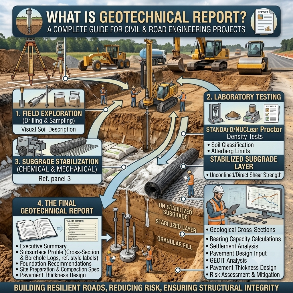
Topic-Related Diagram
Geotechnical Investigation Workflow
Project Planning
       │
       ▼
Desk Study
       │
       ▼
Site Reconnaissance
       │
       ▼
Field Investigation
(Boreholes • Trial Pits • SPT • CPT)
       │
       ▼
Sample Collection
       │
       ▼
Laboratory Testing
       │
       ▼
Engineering Analysis
       │
       ▼
Geotechnical Report
       │
       ▼
Foundation & Pavement Design
Typical Borehole Soil Profile
Ground Surface
──────────────────────────
Topsoil
──────────────────────────
Clay Layer
──────────────────────────
Sand Layer
──────────────────────────
Dense Gravel
──────────────────────────
Weathered Rock
──────────────────────────
Sound Rock
Key Takeaways
Understanding What is Geotechnical Report? is fundamental for anyone involved in civil and road engineering projects. A geotechnical report provides reliable information about subsurface conditions, helping engineers select appropriate foundation systems, design durable pavements, and reduce construction risks. By combining detailed site investigations, field testing, laboratory analysis, and engineering judgment, the report creates a solid foundation for safe, economical, and long-lasting infrastructure. Proper planning and accurate geotechnical data always lead to better engineering decisions and improved project outcomes.
Laboratory Testing in a Geotechnical Report
After completing the field investigation, engineers transport representative soil and rock samples to an accredited laboratory. Laboratory testing provides accurate engineering data that supports safe and economical design decisions.
Each test measures a specific property of the soil. Together, these results help engineers predict how the ground will behave under construction loads and environmental conditions.
Common Laboratory Tests
1. Grain Size Analysis
This test determines the distribution of different particle sizes within the soil.
Engineering Applications
- Classifies soil types.
- Evaluates drainage characteristics.
- Assists pavement design.
- Identifies filter material requirements.
2. Atterberg Limits
This test measures the plasticity of fine-grained soils by determining:
- Liquid Limit (LL)
- Plastic Limit (PL)
- Plasticity Index (PI)
Engineering Applications
- Classifies cohesive soils.
- Identifies expansive clay.
- Predicts shrinkage and swelling.
- Assesses construction suitability.
3. Moisture Content Test
Natural moisture content greatly influences soil strength and compaction.
Engineers use this information to:
- Plan earthwork operations.
- Determine compaction requirements.
- Evaluate field conditions.
- Select stabilization methods.
4. Standard and Modified Proctor Test
The Proctor Test determines:
- Optimum Moisture Content (OMC)
- Maximum Dry Density (MDD)
These values guide field compaction during road construction.
5. California Bearing Ratio (CBR)
The CBR test measures the load-bearing capacity of subgrade soil.
High CBR values indicate stronger soils that require thinner pavement layers, while low values often require soil improvement or thicker pavement structures.
6. Shear Strength Tests
Common shear strength tests include:
- Direct Shear Test
- Triaxial Compression Test
- Unconfined Compression Test
These tests determine soil stability under applied loads.
7. Consolidation Test
This test predicts long-term settlement in cohesive soils.
It is especially important for:
- Highway embankments
- Bridge approaches
- Large commercial buildings
- Retaining structures
Engineering Recommendations Included in a Geotechnical Report
The engineering recommendations section transforms investigation results into practical construction guidance.
Typical recommendations include:
Foundation Design
The report may recommend:
- Shallow foundations
- Raft foundations
- Pile foundations
- Combined footings
- Mat foundations
The selection depends on soil strength and settlement characteristics.
Pavement Design
For road engineering projects, the report provides:
- Subgrade classification
- CBR values
- Pavement design parameters
- Soil improvement requirements
- Compaction recommendations
These values form the basis of flexible and rigid pavement design.
Earthwork Recommendations
The report commonly specifies:
- Suitable fill material
- Maximum layer thickness
- Required compaction percentage
- Moisture control procedures
- Excavation precautions
Proper earthwork practices improve pavement durability and reduce maintenance costs.
Groundwater Control
When groundwater exists near the construction level, engineers may recommend:
- Dewatering systems
- Drainage blankets
- Filter layers
- Subsurface drains
- Waterproofing measures
Proper groundwater management protects both temporary excavations and permanent structures.
Practical Applications in Road and Highway Engineering
Geotechnical reports play a vital role throughout highway development.
Highway Alignment
Engineers use soil information to avoid weak ground, unstable slopes, and high-risk areas whenever practical.
Pavement Thickness Design
Subgrade strength directly influences pavement thickness.
For example:
- Strong subgrade → thinner pavement.
- Weak subgrade → thicker pavement or soil stabilization.
This approach improves pavement performance while optimizing construction costs.
Embankment Construction
Highway embankments require stable foundation soils.
The report helps engineers:
- Evaluate settlement potential.
- Assess slope stability.
- Determine fill material quality.
- Specify compaction requirements.
Bridge Foundations
Bridge designers rely on geotechnical reports to determine:
- Pile length
- Foundation depth
- Bearing capacity
- Settlement limits
- Scour considerations
Slope Stability
Roads passing through hilly terrain often require cut slopes and retaining structures.
Geotechnical investigations help identify potential landslide risks and recommend suitable stabilization methods.
Best Practices for Preparing a High-Quality Geotechnical Report
Experienced geotechnical engineers follow several best practices to improve report quality and reliability.
- Conduct adequate boreholes across the project site.
- Collect representative soil samples.
- Use calibrated testing equipment.
- Follow recognized laboratory procedures.
- Record groundwater observations accurately.
- Interpret results using sound engineering judgment.
- Present recommendations in clear, practical language.
- Include sketches, borehole logs, and soil profiles.
- Update recommendations if site conditions change during construction.
A well-prepared report should support design decisions rather than simply present laboratory data.
Common Mistakes to Avoid
Several avoidable mistakes can reduce the reliability of a geotechnical report.
- Insufficient borehole depth.
- Inadequate sampling locations.
- Ignoring seasonal groundwater variations.
- Using outdated geological information.
- Relying solely on laboratory results without field observations.
- Poor documentation of site conditions.
- Overlooking slope stability.
- Failing to provide construction recommendations.
- Delaying investigations until after design has started.
Avoiding these mistakes reduces project risks and costly design revisions.
Field Recommendations
Civil Engineers
- Review the geotechnical report before starting structural or pavement design.
- Verify that site conditions match the report during construction.
- Reassess recommendations if unexpected soil layers appear.
- Coordinate closely with geotechnical specialists.
Contractors
- Follow excavation recommendations carefully.
- Maintain specified moisture content during compaction.
- Protect excavations from groundwater intrusion.
- Report unexpected ground conditions immediately.
Engineering Students
- Understand how soil properties affect structural performance.
- Learn common field investigation methods.
- Practice interpreting borehole logs.
- Study laboratory testing procedures and engineering applications.
- Visit construction sites to connect theory with real-world practice.
General Discussion of IRC, AASHTO, and ICE Practices
Highway and infrastructure agencies worldwide emphasize the importance of comprehensive geotechnical investigations before construction begins.
Although project requirements vary, guidance from organizations such as IRC (Indian Roads Congress), AASHTO (American Association of State Highway and Transportation Officials), and ICE (Institution of Civil Engineers) generally promotes the following principles:
- Perform detailed site investigations before final design.
- Base pavement design on reliable subgrade data.
- Conduct appropriate laboratory and field testing.
- Evaluate groundwater conditions during design.
- Ensure proper compaction of earthworks.
- Monitor construction quality continuously.
- Maintain complete geotechnical documentation throughout the project lifecycle.
- Apply engineering judgment alongside laboratory data.
Following these widely accepted principles improves project safety, durability, and long-term performance.
Frequently Asked Questions (FAQs)
1. What is a geotechnical report?
A geotechnical report is an engineering document that describes soil, rock, and groundwater conditions while providing recommendations for safe foundation, pavement, and earthwork design.
2. Why is a geotechnical report important?
It reduces construction risks, supports economical design, improves structural safety, and helps prevent settlement, slope failures, and pavement distress.
3. Who prepares a geotechnical report?
A qualified geotechnical engineer prepares the report after completing field investigations, laboratory testing, and engineering analysis.
4. When should a geotechnical investigation be carried out?
The investigation should take place during the planning and design stage before finalizing structural or pavement designs.
5. What information does a geotechnical report contain?
It usually includes site descriptions, borehole logs, laboratory test results, groundwater observations, engineering analysis, and design recommendations.
6. How does a geotechnical report help highway engineers?
It provides subgrade strength, soil classification, groundwater information, and pavement design parameters that support durable and cost-effective highway construction.
7. What is the difference between a soil investigation and a geotechnical report?
A soil investigation involves collecting field and laboratory data, while a geotechnical report analyzes that data and provides engineering recommendations for design and construction.
8. Can construction begin without a geotechnical report?
Small projects may proceed with limited investigations in some situations, but most commercial buildings, bridges, and highway projects require a comprehensive geotechnical report to reduce engineering risks.
9. How often should groundwater levels be monitored?
Monitoring frequency depends on project requirements, seasonal variations, and site conditions. Long-term observations often provide more reliable design information than a single measurement.
10. What happens if unexpected soil conditions appear during construction?
Engineers should stop affected work, investigate the new conditions, and revise the design or construction method if necessary before continuing.
Conclusion
Understanding What is Geotechnical Report? is essential for every civil engineer, road engineer, contractor, and engineering student. A geotechnical report provides the technical foundation for safe and economical construction by identifying subsurface conditions, evaluating soil and groundwater behavior, and recommending practical engineering solutions. From highway pavements and embankments to bridges and retaining walls, nearly every infrastructure project depends on accurate geotechnical information. Careful field investigations, reliable laboratory testing, and professional engineering judgment reduce construction risks, improve structural performance, and extend the service life of infrastructure. By following recognized engineering practices and using a well-prepared geotechnical report, project teams can make informed decisions that enhance safety, quality, and long-term value. Understanding What is Geotechnical Report? is therefore a critical step toward successful project planning and execution.
