
Introduction
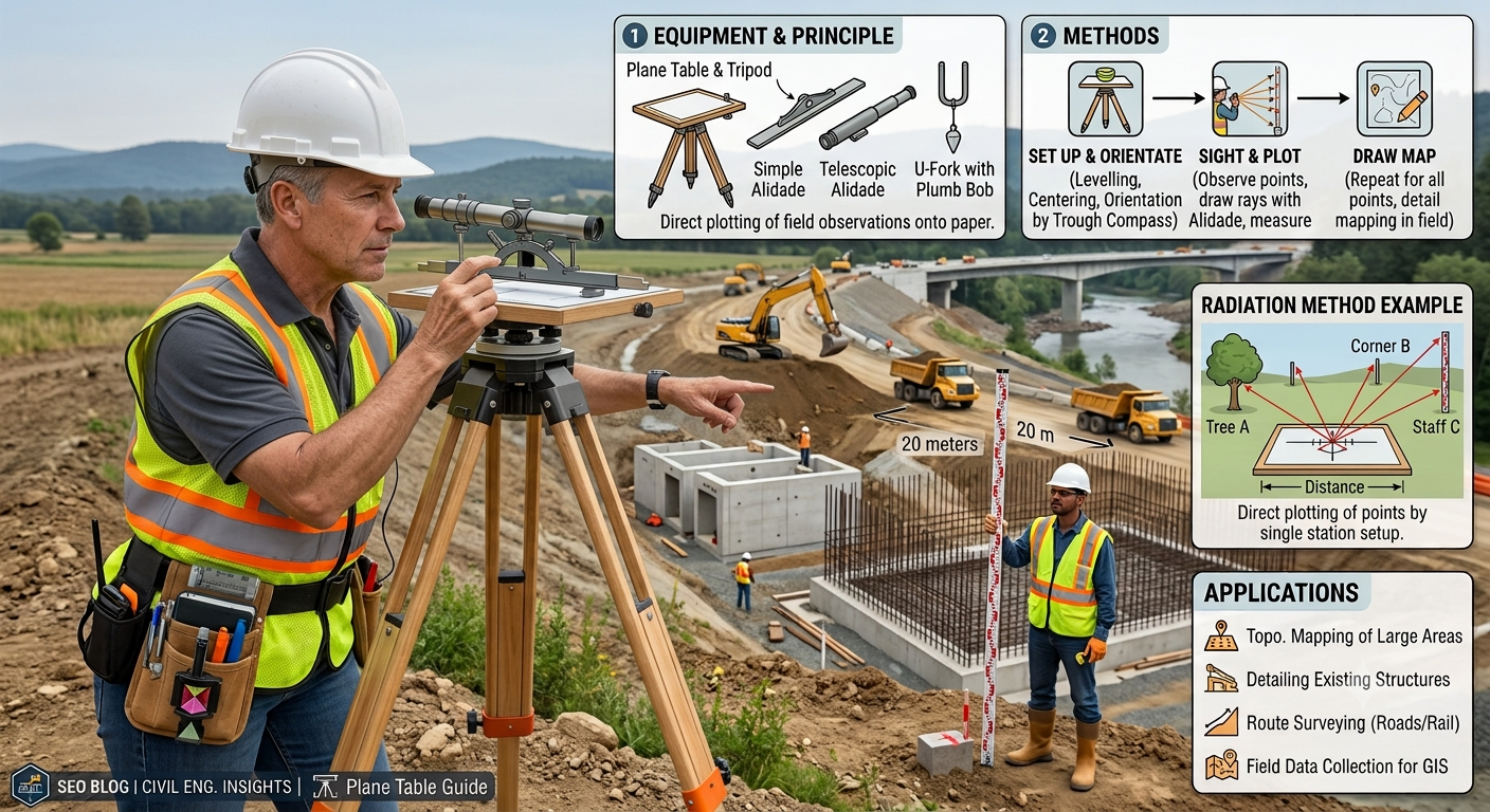
Plane Table Survey remains one of the simplest and most practical surveying methods used in civil engineering. Despite the availability of advanced technologies such as Total Stations, GPS, and drones, engineers still use plane table surveying for small-scale projects, preliminary investigations, reconnaissance surveys, and educational fieldwork. The method allows surveyors to observe the ground and prepare maps simultaneously, which reduces office work and minimizes plotting errors.
Unlike many traditional surveying techniques, Plane Table Survey combines measurement and drawing in a single operation. Surveyors plot field details directly on a drawing sheet while observing the site. This approach provides immediate visual verification of the survey and allows quick corrections if discrepancies appear.
In road engineering, Plane Table Survey supports route reconnaissance, topographic mapping, drainage planning, and preliminary alignment studies. Engineering students also learn this method because it develops practical surveying skills and strengthens the understanding of mapping principles.
This comprehensive guide explains the principles, equipment, methods, engineering applications, advantages, limitations, and best practices of Plane Table Survey using practical examples and easy-to-understand explanations.
Table of Contents
What is Plane Table Survey?
History of Plane Table Survey
Principle of Plane Table Survey
Equipment Used in Plane Table Survey
Plane Table Board
Tripod Stand
Alidade
Plumbing Fork and Plumb Bob
Spirit Level
Trough Compass
Drawing Sheet and Accessories
Types of Plane Table Survey
Methods of Plane Table Survey
Radiation Method
Intersection Method
Traversing Method
Resection Method
Practical Engineering Applications
Advantages and Disadvantages
Field Procedure
Common Errors
Best Practices
FAQs
Conclusion
What is Plane Table Survey?
Plane Table Survey is a graphical surveying method in which field observations and map plotting take place simultaneously on a drawing sheet fixed to a flat table.
Instead of recording measurements in a field book and preparing maps later, the surveyor draws the map directly at the survey site. This feature makes the method simple, quick, and highly suitable for small areas where extreme precision is not required.
The surveyor places a drawing sheet on the plane table, levels the instrument, orients it correctly, and plots field details using an alidade.
Definition
Plane Table Survey is a surveying technique that determines the relative positions of ground features by direct observation and immediate graphical plotting on a plane table.
History of Plane Table Survey
Plane table surveying has served engineers for several centuries. Early surveyors adopted this method because it simplified field mapping and eliminated the need for extensive office calculations.
Although electronic surveying equipment now dominates large infrastructure projects, plane table surveying continues to play an important role in:
- Preliminary road surveys
- Topographic mapping
- Archaeological surveys
- Educational training
- Small construction projects
- Land development planning
Many engineering institutions still include Plane Table Survey in surveying laboratories because it strengthens practical observation and plotting skills.
Principle of Plane Table Survey
The basic principle of Plane Table Survey is straightforward:
“Observe the object and plot its position directly on the drawing sheet from the corresponding station.”
This principle ensures that the map develops as the survey progresses.
Instead of relying on lengthy numerical computations, the surveyor transfers field observations immediately to the drawing sheet.
Engineering Principle
The method depends on maintaining parallelism between:
- The actual survey line on the ground
- The corresponding plotted line on the drawing sheet
Accurate orientation and careful sighting ensure that plotted features maintain their correct relative positions.
Equipment Used in Plane Table Survey
Several simple instruments work together during Plane Table Survey. Each item performs a specific function that contributes to accurate mapping.
1. Plane Table Board
The plane table board provides a smooth, flat surface for fixing the drawing sheet.
Functions
- Supports the drawing sheet
- Provides a stable plotting surface
- Rotates for orientation
- Maintains drawing accuracy
Typical boards are made from well-seasoned wood or lightweight composite materials.
2. Tripod Stand
The tripod supports the plane table and keeps it stable during fieldwork.
Characteristics
- Adjustable legs
- Firm ground support
- Easy transportation
- Stable platform
Proper tripod setup prevents unwanted movement while plotting.
3. Alidade
The alidade serves as the primary sighting instrument.
It consists of a straightedge fitted with sight vanes or a telescopic sight.
Functions
- Sighting field objects
- Drawing sight lines
- Measuring directions
- Improving plotting accuracy
Types
- Plain Alidade
- Telescopic Alidade
Telescopic alidades improve accuracy over longer distances.
4. Plumbing Fork and Plumb Bob
This instrument helps position the plotted station exactly above the corresponding ground station.
Purpose
- Centering the table
- Accurate station transfer
- Maintaining positional accuracy
Proper centering reduces plotting errors throughout the survey.
5. Spirit Level
The spirit level ensures that the plane table remains perfectly horizontal.
Importance
A level table:
- Prevents distorted drawings
- Improves plotting precision
- Simplifies orientation
Even a slight tilt can introduce significant positional errors.
6. Trough Compass
The trough compass helps orient the plane table according to magnetic north.
Uses
- Initial orientation
- Re-orientation at new stations
- Maintaining consistent map direction
Correct orientation forms the foundation of accurate Plane Table Survey.
7. Drawing Sheet and Accessories
Essential accessories include:
- Drawing paper
- Pencils
- Eraser
- Scale
- Clips or thumb pins
- Protractor
High-quality drawing sheets improve durability during field operations.
Equipment Arrangement Diagram
                 Alidade
                    │
        ┌─────────────────────┐
        │     Plane Table     │
        │   Drawing Sheet     │
        └─────────────────────┘
                 │
            Tripod Stand
           /      │      \
          /       │       \
         /        │        \
      Adjustable Legs
Types of Plane Table Survey
Surveyors generally classify Plane Table Survey according to the method used for locating points.
The four standard methods are:
- Radiation Method
- Intersection Method
- Traversing Method
- Resection Method
Each method serves different surveying situations.
Methods of Plane Table Survey
1. Radiation Method
The Radiation Method is the simplest Plane Table Survey technique.
The surveyor selects a single station and measures the distances to all surrounding points.
Each object is plotted by drawing rays from the station and marking the measured distance along each ray.
Procedure
- Set up the plane table at the survey station.
- Level and center the table.
- Orient the table.
- Draw rays toward each object using the alidade.
- Measure ground distances.
- Plot each point to scale.
Radiation Method Diagram
              Tree
                ●
               /
              /
             /
Building ●---S------● Pole
             \
              \
               \
                ●
             Culvert

S = Survey Station
Applications
- Small construction sites
- Open fields
- Building layouts
- Preliminary road surveys
- Small topographic maps
Advantages
- Simple procedure
- Fast fieldwork
- Minimal equipment
- Easy plotting
Limitation
Accuracy decreases as the distance from the survey station increases.
2. Intersection Method
The Intersection Method determines the location of objects by drawing intersecting rays from two different stations.
Surveyors use this method when direct distance measurement becomes difficult or impossible.
Procedure
- Select two survey stations.
- Measure the baseline accurately.
- Plot the baseline.
- Sight the object from Station A.
- Sight the same object from Station B.
- The intersection of the rays gives the object’s position.
Intersection Method Diagram
          Object
             ●
            / \
           /   \
          /     \
         /       \
        A---------B

A and B = Survey Stations
Practical Example
Suppose engineers need to locate a river island while planning a highway bridge. Measuring the distance across the river is difficult and time-consuming. By establishing two survey stations on the riverbank and using the Intersection Method, they can accurately determine the island’s position without crossing the water.
Engineering Applications
- River crossings
- Bridge investigations
- Valley surveys
- Highway reconnaissance
- Mountain terrain mapping
Practical Applications of Plane Table Survey in Road Engineering
Although modern electronic instruments dominate large-scale projects, Plane Table Survey remains useful during the early stages of road development.
Common applications include:
- Preliminary route reconnaissance
- Topographic mapping
- Drainage channel surveys
- Culvert location planning
- Small bridge approaches
- Road intersection layout
- Borrow area mapping
- Construction camp planning
- Earthwork estimation for small projects
The method allows engineers to visualize terrain conditions immediately, making it valuable for quick field decisions during project planning.
Methods of Plane Table Survey (Continued)
3. Traversing Method
The Traversing Method suits projects that require surveying along a continuous route. Road engineers frequently select this method during preliminary highway alignment studies, canal surveys, railway surveys, and pipeline investigations.
In this method, the surveyor shifts the plane table from one station to the next while maintaining proper orientation. Each new station extends the survey until it covers the entire route.
Procedure
- Select the first survey station.
- Set up, center, and level the plane table.
- Plot the first station on the drawing sheet.
- Measure the distance to the next station.
- Move the instrument to the new station.
- Orient the table using the previous survey line.
- Continue plotting additional stations until the traverse ends.
Traversing Method Diagram
A -------- B -------- C -------- D -------- E

A, B, C, D and E = Survey Stations
Engineering Applications
- Highway route surveys
- Railway alignment
- Irrigation canals
- Utility corridors
- Long boundary surveys
4. Resection Method
The Resection Method helps surveyors determine the position of the plane table when the station location remains unknown. Instead of measuring distances, the surveyor identifies the position by observing known reference points.
Surveyors often apply this method after moving to a new station where plotted control points already exist on the map.
Common Types of Resection
- Two-point resection
- Three-point resection
- Bessel’s method
- Trial and error method
Procedure
- Set up the plane table at the unknown station.
- Orient the table approximately.
- Sight two or three known control points.
- Draw rays toward each known point.
- Adjust the orientation until all rays intersect correctly.
- Mark the station position.
Resection Diagram
          C
         ●
        / \
       /   \
      /     \
     ●-------●
    A         B

A, B, C = Known Control Points
P = Unknown Station (located by resection)
Practical Example
During a road reconnaissance survey in hilly terrain, engineers may lose access to an established control point. By using three visible reference stations, they can quickly determine the new survey position without repeating the entire survey.
Field Procedure of Plane Table Survey
A systematic procedure improves both efficiency and accuracy.
Step 1: Select the Survey Station
Choose a location that provides clear visibility of the surrounding area.
Step 2: Fix the Drawing Sheet
Secure the sheet firmly to the plane table using clips or thumb pins.
Step 3: Center the Plane Table
Position the table directly above the survey station with a plumbing fork and plumb bob.
Step 4: Level the Instrument
Use the spirit level to make the board perfectly horizontal.
Step 5: Orient the Plane Table
Align the drawing sheet with the previous survey line or magnetic north using the trough compass.
Step 6: Observe and Plot
Sight each object with the alidade and draw rays directly on the sheet.
Step 7: Measure Distances
Measure required distances using a tape or chain and plot them to scale.
Step 8: Verify the Survey
Check plotted details before leaving the site to avoid costly revisits.
Complete Plane Table Survey Workflow
Select Survey Station
          │
          ▼
Set Up Tripod
          │
          ▼
Center & Level Table
          │
          ▼
Orient Table
          │
          ▼
Sight Objects
          │
          ▼
Measure Distances
          │
          ▼
Plot Details
          │
          ▼
Check Accuracy
          │
          ▼
Move to Next Station
Advantages of Plane Table Survey
Plane Table Survey offers several practical benefits, especially for small and medium-sized engineering projects.
Major Advantages
- Field observations and plotting occur simultaneously.
- Surveyors identify errors immediately.
- The method requires simple and inexpensive equipment.
- Office calculations remain minimal.
- Engineers prepare maps quickly.
- The survey suits irregular terrain.
- The method supports rapid reconnaissance surveys.
- Beginners learn surveying principles easily.
- Engineers can modify maps directly in the field.
- The survey performs well for small construction projects.
Disadvantages of Plane Table Survey
Although useful, Plane Table Survey also has limitations.
Major Limitations
- The method delivers lower accuracy than Total Station or GPS surveys.
- Rain and strong winds interrupt fieldwork.
- Large projects require more advanced equipment.
- Paper drawings may become damaged.
- Dense forests reduce visibility.
- Long-distance observations decrease accuracy.
- Strong magnetic disturbances affect orientation.
- The survey depends heavily on operator skill.
Common Errors in Plane Table Survey
Several mistakes can reduce survey accuracy.
Common Sources of Error
- Incorrect centering
- Poor leveling
- Improper orientation
- Faulty sighting
- Drawing sheet movement
- Inaccurate distance measurement
- Instrument instability
- Human plotting mistakes
How to Reduce Errors
- Check leveling frequently.
- Secure the drawing sheet tightly.
- Verify orientation at every station.
- Use calibrated measuring equipment.
- Keep the tripod stable.
- Repeat important observations.
- Inspect plotted points before moving.
Best Practices
Experienced surveyors follow proven practices to improve field efficiency.
- Inspect equipment before starting work.
- Select stable survey stations.
- Protect drawing sheets from moisture.
- Use sharp pencils for clear plotting.
- Maintain accurate field notes.
- Verify measurements regularly.
- Avoid surveying during heavy rain or strong winds.
- Check orientation whenever the table moves.
- Keep instruments clean and well maintained.
- Compare plotted features with actual ground conditions.
Practical Recommendations
Civil Engineers
- Use Plane Table Survey during reconnaissance and preliminary alignment studies.
- Verify important control points with modern surveying equipment.
- Integrate field sketches with digital mapping software where appropriate.
Contractors
- Apply Plane Table Survey for temporary works, construction layouts, and site planning.
- Train survey crews in proper centering and orientation techniques.
- Protect surveying equipment during transportation and storage.
Engineering Students
- Practice each surveying method in the field.
- Develop strong observation and plotting skills.
- Understand the purpose of every instrument before conducting surveys.
- Compare plane table results with Total Station measurements to appreciate differences in accuracy.
Engineering Applications of Plane Table Survey
Plane Table Survey continues to support many engineering activities.
Road Engineering
- Highway reconnaissance
- Preliminary route selection
- Road intersection planning
- Drainage layout
- Borrow pit mapping
Civil Engineering
- Building site planning
- Campus mapping
- Small subdivision layouts
- Utility planning
Water Resources Engineering
- Canal alignment
- Reservoir surveys
- Riverbank mapping
Environmental Engineering
- Wetland mapping
- Forest boundary surveys
- Land restoration planning
General Discussion of IRC, AASHTO, and ICE Practices
Although modern projects increasingly rely on Total Stations, GNSS, LiDAR, and drone-based mapping, organizations such as IRC, AASHTO, and ICE emphasize the importance of accurate survey control, reliable topographic data, and proper field verification before design and construction.
General engineering guidance recommends:
- Establishing accurate control points before detailed surveys.
- Verifying field observations through quality checks.
- Selecting surveying methods based on project size, required accuracy, terrain, and available resources.
- Maintaining clear documentation and survey records.
- Combining traditional surveying techniques with modern digital technologies whenever practical.
These principles help engineers produce dependable survey data for highway, bridge, and infrastructure projects.
Frequently Asked Questions (FAQs)
1. What is Plane Table Survey?
Plane Table Survey is a graphical surveying method in which surveyors observe ground features and plot them directly on a drawing sheet fixed to a plane table.
2. Where is Plane Table Survey commonly used?
Engineers commonly use it for reconnaissance surveys, topographic mapping, preliminary road alignment, small construction projects, and educational field exercises.
3. Which instrument plays the most important role in Plane Table Survey?
The alidade serves as the primary sighting instrument because it helps draw accurate sight lines toward ground objects.
4. What are the four methods of Plane Table Survey?
The four standard methods are Radiation, Intersection, Traversing, and Resection.
5. Why does Plane Table Survey require proper orientation?
Correct orientation ensures that plotted directions remain parallel to their corresponding ground directions, improving map accuracy.
6. What factors affect the accuracy of Plane Table Survey?
Centering, leveling, orientation, sighting precision, weather conditions, and operator experience all influence survey accuracy.
7. Is Plane Table Survey suitable for large highway projects?
It works best for reconnaissance and preliminary surveys. Large highway projects generally require Total Stations, GNSS, LiDAR, and other high-precision technologies for detailed design.
8. What are the main advantages of Plane Table Survey?
The method offers rapid field mapping, immediate plotting, simple equipment, minimal office work, and easy error detection.
9. Can Plane Table Survey work in hilly terrain?
Yes. Surveyors frequently use it in hilly and irregular terrain during preliminary investigations, provided they maintain clear visibility between stations.
10. Why do engineering students still learn Plane Table Survey?
The method develops observation skills, improves understanding of surveying principles, and provides a strong foundation for learning advanced surveying technologies.
Conclusion
Plane Table Survey remains one of the most practical and educational surveying techniques in civil engineering. Although advanced technologies such as GNSS, Total Stations, and drone mapping now dominate large-scale infrastructure projects, this graphical method continues to provide significant value during reconnaissance surveys, preliminary route selection, topographic mapping, and classroom training. Its ability to combine field observation with immediate plotting allows surveyors to identify errors on-site, improve efficiency, and produce reliable maps for small and medium-sized projects. Engineers, contractors, and students who understand the principles, equipment, methods, and limitations of Plane Table Survey can select the most suitable surveying approach for each project. When applied with proper centering, leveling, orientation, and quality control, Plane Table Survey remains an effective, economical, and dependable technique that strengthens the foundation of successful road and civil engineering projects.
