
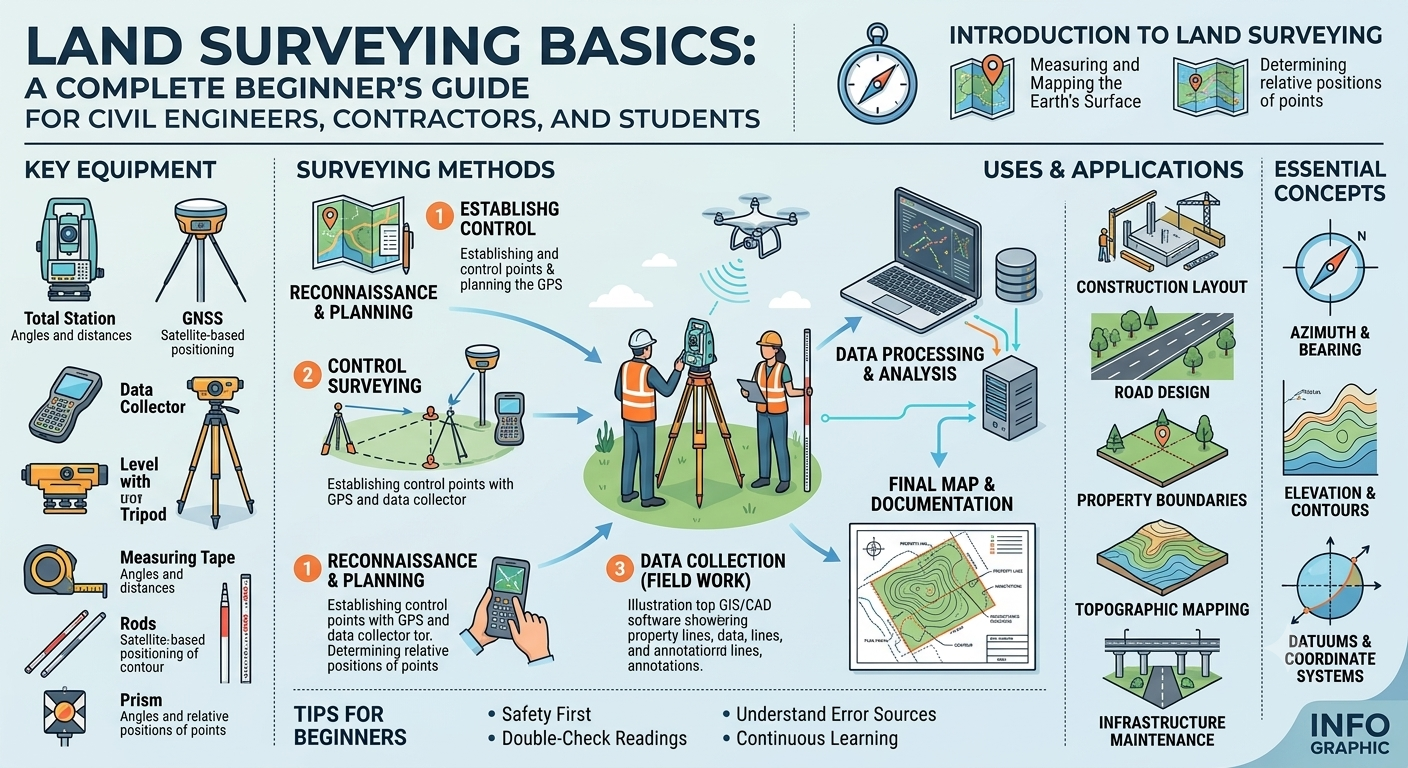
Land surveying is one of the oldest and most fundamental disciplines in civil engineering. Every successful construction project—whether it involves a residential building, highway, bridge, railway, dam, or commercial development—begins with an accurate survey of the land. Without reliable survey data, engineers cannot determine property boundaries, prepare design drawings, estimate earthwork quantities, or position structures correctly.
Understanding Land Surveying Basics is essential for civil engineers, transportation engineers, architects, contractors, and engineering students. Surveying provides the measurements and spatial information needed to transform design concepts into reality. Modern surveying combines traditional field techniques with advanced technologies such as Global Navigation Satellite Systems (GNSS), Total Stations, drones, and Geographic Information Systems (GIS), making projects more accurate and efficient than ever before.
This guide explains the fundamentals of land surveying, including its principles, types, equipment, measurement methods, and engineering applications. It is written using practical examples and industry-recognized practices to help both beginners and experienced professionals strengthen their understanding of this essential engineering field.
What Is Land Surveying?
Land surveying is the science and art of determining the relative positions of points, lines, and features on or near the Earth’s surface. It involves measuring distances, angles, elevations, and coordinates to create accurate maps, plans, and construction layouts.
Surveyors collect field data that engineers use to design infrastructure, define legal property boundaries, calculate earthwork quantities, and guide construction activities. Accurate surveying minimizes errors during construction and helps ensure that completed projects match their approved designs.
In civil engineering, surveying serves as the foundation for nearly every stage of a project, from initial planning and design to construction and maintenance.
Objectives of Land Surveying
The primary objectives include:
- Establishing property boundaries.
- Preparing topographic maps.
- Collecting ground elevation data.
- Supporting highway and railway alignment.
- Assisting bridge and dam construction.
- Calculating land areas and volumes.
- Setting out construction works accurately.
- Monitoring structural movement and deformation.
Why Land Surveying Is Important
Accurate surveying contributes directly to the safety, efficiency, and success of engineering projects. Incorrect measurements can lead to design errors, construction delays, legal disputes, and costly rework.
Benefits of Land Surveying
- Provides reliable site information before design begins.
- Ensures structures are built in the correct location.
- Helps determine existing ground levels.
- Supports drainage and earthwork design.
- Prevents encroachment on neighboring properties.
- Reduces construction risks and material waste.
- Improves project planning and scheduling.
- Enhances overall construction quality.
Practical Example
Before constructing a new highway, surveyors establish the proposed centerline, identify existing terrain, locate utilities, and measure elevations. Engineers then use this information to design the road alignment, drainage system, and pavement structure. Without these survey results, the highway design would lack the accuracy needed for safe and efficient construction.
Basic Principles of Land Surveying
Every surveying project is guided by established engineering principles that help ensure accuracy and consistency.
Accuracy and Precision
Although often used interchangeably, accuracy and precision have different meanings.
- Accuracy refers to how close a measurement is to its true value.
- Precision describes how closely repeated measurements agree with one another.
High-quality surveying requires both accurate and precise observations to produce dependable results.
Working from Whole to Part
One of the most important surveying principles is to establish a network of primary control points before measuring smaller details.
This approach helps contain measurement errors and prevents them from accumulating throughout the survey.
For example, surveyors first establish permanent control stations across the project area and then use those points to locate individual features such as roads, buildings, drainage channels, and utilities.
Establishing Control Points
Control points are fixed reference locations with known coordinates and elevations. They provide a consistent framework for all future measurements.
Control points are essential because they:
- Maintain survey consistency.
- Improve measurement accuracy.
- Simplify future construction layout.
- Enable different survey teams to work using the same reference system.
Error Detection and Adjustment
No field measurement is completely free from error. Surveyors therefore apply systematic procedures to detect and minimize measurement inaccuracies.
Common quality checks include:
- Repeating observations.
- Closing traverses.
- Double-checking instrument setup.
- Comparing field measurements with design data.
- Applying mathematical adjustments where appropriate.
These practices improve confidence in the final survey results.
Types of Land Surveying
Different engineering projects require different surveying methods. The choice depends on the project’s objectives, terrain, and required accuracy.
Topographic Survey
A topographic survey records both natural and man made features along with ground elevations.
Features commonly surveyed include:
- Hills and valleys
- Rivers and streams
- Roads
- Buildings
- Trees
- Utility lines
- Drainage systems
Topographic surveys provide the base maps used for planning and engineering design.
Boundary Survey
Boundary surveys establish the legal limits of a property.
Surveyors identify property corners, verify ownership boundaries, and prepare legal descriptions for land registration, property transfers, and dispute resolution.
These surveys are particularly important before purchasing land or beginning construction.
Construction Survey
Construction surveying transfers engineering designs from drawings to the actual project site.
Surveyors mark the precise locations of:
- Building foundations
- Road centerlines
- Bridge piers
- Utility networks
- Drainage structures
This process ensures that every element is constructed according to the approved design.
Route Survey
Route surveys are conducted for linear infrastructure projects such as:
- Highways
- Railways
- Pipelines
- Canals
- Transmission lines
These surveys help engineers select the most suitable alignment while considering terrain, environmental conditions, and construction costs.
Hydrographic Survey
Hydrographic surveys measure underwater features in rivers, lakes, reservoirs, and coastal areas.
They are commonly performed for:
- Bridge construction
- Port development
- Dam projects
- Navigation channels
- Flood studies
These surveys provide information about water depths, riverbeds, and underwater obstructions.
Essential Surveying Equipment
The quality of a survey depends not only on the surveyor’s skills but also on the accuracy and suitability of the equipment used.
Traditional Surveying Instruments
Traditional tools include:
- Measuring tape
- Survey chain
- Compass
- Dumpy level
- Levelling staff
- Plane table
- Theodolite
Although many of these instruments are still used for educational purposes and smaller projects, modern engineering relies increasingly on digital equipment.
Modern Surveying Instruments
Technological advances have transformed surveying by improving speed, precision, and efficiency.
Common modern instruments include:
Total Station
A Total Station combines an electronic theodolite with an electronic distance measurement (EDM) system. It measures angles, distances, and coordinates while storing data digitally for later processing.
GNSS/GPS Receivers
Global Navigation Satellite Systems (GNSS) provide accurate positioning by receiving signals from satellites. These systems are widely used for large-scale mapping, control surveys, and infrastructure projects.
Digital Level
Digital levels automatically read coded staffs and calculate elevations with greater accuracy than conventional optical levels.
Unmanned Aerial Vehicles (Drones)
Survey drones equipped with high-resolution cameras or LiDAR sensors quickly capture aerial imagery and terrain data, making them valuable for topographic mapping, earthwork estimation, and construction monitoring.
Basic Surveying Measurements
Surveying involves measuring three primary quantities: distance, angles, and elevation.
Distance Measurement
Distances can be measured using:
- Measuring tapes
- EDM instruments
- Total Stations
- GNSS equipment
Accurate distance measurement is essential for boundary definition, construction layout, and mapping.
Angle Measurement
Horizontal and vertical angles are measured using theodolites or Total Stations.
Angle measurements help determine directions, establish alignments, and calculate coordinates.
Elevation Measurement
Elevation refers to the height of a point relative to a reference level, typically mean sea level or a project datum.
Engineers use elevation data to design:
- Road gradients
- Drainage systems
- Foundations
- Earthworks
- Flood protection measures
Levelling operations are performed using optical or digital levels to determine these height differences accurately.
Simple Surveying Diagram
                 Control Point A
                       ●
                      / \
                     /   \
                    /     \
                   /       \
                  /         \
                 ●-----------●
        Control Point B     Control Point C

             ↓ Detail Survey

       Buildings • Roads • Trees
       Utilities • Drainage • Boundaries
The diagram illustrates how permanent control points provide the framework for measuring and locating all site features accurately.
Land Surveying Procedure: Step-by-Step
A successful survey follows a systematic workflow that ensures reliable measurements and minimizes errors. Each stage builds upon the previous one, allowing engineers and surveyors to collect accurate field data for planning, design, and construction.
Step 1: Project Planning
Before visiting the site, surveyors review the project requirements, available maps, legal documents, and previous survey records. They also determine the survey method, required accuracy, equipment, workforce, and estimated timeline.
Activities Performed
- Review project objectives.
- Study existing maps and drawings.
- Identify survey boundaries.
- Prepare field equipment.
- Develop a survey plan.
- Conduct a safety assessment.
Proper planning reduces delays and helps avoid unnecessary fieldwork.
Step 2: Reconnaissance Survey
Reconnaissance is a preliminary site inspection carried out before detailed measurements begin.
During this visit, surveyors examine:
- Terrain conditions
- Existing roads
- Buildings
- Utility lines
- Water bodies
- Vegetation
- Access routes
- Potential obstacles
This assessment helps determine suitable control point locations and the most efficient survey technique.
Step 3: Establishing Control Points
Control points provide fixed reference positions for the entire survey.
These points are carefully selected in stable locations where they are unlikely to be disturbed during construction.
Control stations should:
- Be easily visible.
- Remain accessible.
- Have permanent markers.
- Be protected from damage.
- Maintain clear lines of sight.
Accurate control points ensure that every measurement remains consistent throughout the project.
Step 4: Field Measurements
After establishing the control network, surveyors begin collecting detailed field data.
Typical measurements include:
- Horizontal distances
- Vertical elevations
- Horizontal angles
- Vertical angles
- Coordinates
- Existing structures
- Natural ground features
Modern Total Stations and GNSS receivers allow surveyors to record thousands of points quickly with high precision.
Step 5: Data Processing
Once fieldwork is complete, the collected data is transferred to specialized surveying or CAD software.
Engineers process the observations to:
- Calculate coordinates.
- Generate contour maps.
- Prepare digital terrain models (DTMs).
- Create cross-sections and longitudinal profiles.
- Compute earthwork quantities.
Software significantly improves accuracy while reducing manual calculation errors.
Step 6: Preparing Survey Drawings
The processed data is used to produce engineering drawings and reports.
Typical deliverables include:
- Topographic maps
- Site plans
- Boundary plans
- Alignment drawings
- Contour maps
- Construction layout drawings
- Earthwork calculations
These documents become the foundation for engineering design and construction.
Practical Applications of Land Surveying
Land surveying supports a wide range of civil engineering and infrastructure projects.
Highway Engineering
Surveyors establish:
- Highway centerlines
- Road alignments
- Cross-sections
- Longitudinal profiles
- Drainage layouts
These measurements enable transportation engineers to design safe and efficient road networks.
Building Construction
Before construction begins, surveyors accurately locate:
- Building corners
- Foundation lines
- Columns
- Property boundaries
- Utility corridors
Accurate layout prevents structural misalignment and costly corrections.
Bridge Engineering
Bridge projects require precise surveys to determine:
- River alignment
- Pier locations
- Abutment positions
- Water levels
- Foundation elevations
Even minor errors can affect structural stability and construction safety.
Railway Projects
Railway surveys help engineers design:
- Track alignment
- Curves
- Gradients
- Stations
- Drainage systems
Precise measurements improve passenger comfort and operational safety.
Urban Planning
Surveying also contributes to:
- Residential developments
- Smart cities
- Industrial zones
- Utility mapping
- Land subdivision
- Municipal planning
Accurate spatial information allows planners to optimize land use and infrastructure placement.
Common Surveying Errors and How to Avoid Them
Although modern instruments are highly accurate, errors can still occur if proper procedures are not followed.
Instrument Errors
These may result from:
- Poor calibration
- Damaged equipment
- Manufacturing defects
Solution: Regularly calibrate and maintain all surveying instruments.
Human Errors
Examples include:
- Incorrect readings
- Poor instrument setup
- Recording mistakes
- Data entry errors
Solution: Follow standard operating procedures, repeat critical observations, and verify field notes.
Natural Errors
Environmental conditions can affect measurements.
Examples include:
- Temperature variations
- Wind
- Atmospheric refraction
- Earth curvature
- Poor satellite visibility
Solution: Plan surveys during favorable weather conditions and apply necessary corrections.
Engineering Best Practices
Professional surveyors follow proven practices to maintain quality and reliability.
Recommended Practices
- Verify equipment calibration before every project.
- Establish stable control networks.
- Use redundant measurements for critical observations.
- Record complete field notes.
- Back up digital survey data regularly.
- Protect permanent benchmarks.
- Validate survey results before issuing drawings.
- Follow recognized surveying standards and project specifications.
- Coordinate closely with design and construction teams.
- Review completed work through independent quality checks.
These practices reduce errors and improve confidence in survey outcomes.
Practical Recommendations
Civil Engineers
- Review survey reports before beginning design work.
- Confirm that control points match the project coordinate system.
- Use updated survey information throughout the project lifecycle.
- Coordinate with survey teams during construction.
Contractors
- Verify layout points before excavation.
- Protect survey benchmarks during construction.
- Inform surveyors before altering site conditions.
- Recheck critical dimensions before concrete placement.
Engineering Students
- Practice using surveying instruments in the field.
- Learn both traditional and digital surveying methods.
- Understand coordinate systems and map projections.
- Develop proficiency in CAD and surveying software.
- Participate in site visits to connect theory with practical applications.
General Discussion of IRC, AASHTO, and ICE Practices
International engineering organizations emphasize the importance of accurate surveying as the foundation of successful infrastructure projects.
In general, recognized engineering guidance encourages:
- Establishing reliable horizontal and vertical control networks before design.
- Performing detailed topographic and geotechnical surveys for major transportation projects.
- Using calibrated instruments and qualified personnel.
- Maintaining comprehensive survey documentation and quality assurance records.
- Integrating surveying data with digital design platforms such as CAD, GIS, and Building Information Modeling (BIM).
- Verifying survey accuracy before construction activities commence.
- Updating survey information whenever significant site changes occur.
These widely accepted principles help improve project accuracy, safety, efficiency, and long-term performance.
Frequently Asked Questions (FAQs)
1. What is land surveying?
Land surveying is the process of measuring and mapping the Earth’s surface to determine the positions, elevations, boundaries, and dimensions of natural and man made features.
2. Why is land surveying important before construction?
Surveying provides accurate site information that engineers use for planning, design, construction layout, drainage, and earthwork calculations while preventing costly errors.
3. What is the difference between a boundary survey and a topographic survey?
A boundary survey identifies legal property limits, whereas a topographic survey maps ground elevations and physical features such as roads, buildings, trees, and drainage systems.
4. Which instrument is commonly used in modern land surveying?
The Total Station is one of the most widely used instruments because it combines angle measurement, distance measurement, and coordinate calculation in a single device.
5. What are control points in surveying?
Control points are permanent reference locations with known coordinates and elevations used to ensure measurement consistency throughout a survey project.
6. How do GNSS and GPS improve surveying?
GNSS technology provides accurate positioning over large areas, allowing surveyors to complete projects faster while maintaining high levels of precision.
7. What causes errors during surveying?
Errors may arise from instrument issues, human mistakes, or environmental conditions such as temperature changes, wind, or poor satellite reception.
8. Which software is commonly used for survey data processing?
Survey data is commonly processed using CAD software, GIS platforms, and specialized surveying applications to create maps, terrain models, and construction drawings.
9. Can drones replace traditional land surveying methods?
Drones significantly improve efficiency for mapping large areas and generating terrain models. However, they complement rather than completely replace ground-based surveys, especially where very high precision or legal boundary definition is required.
10. What skills should a professional surveyor develop?
A skilled surveyor should understand field measurement techniques, coordinate systems, mapping principles, surveying instruments, CAD software, GIS, data analysis, and effective communication with engineering teams.
Conclusion
Understanding Land Surveying Basics is essential for anyone involved in civil engineering, transportation engineering, construction, or land development. Accurate surveying provides the reliable data needed for planning, designing, and constructing safe, efficient, and durable infrastructure. From establishing control points and measuring distances to preparing topographic maps and construction layouts, every surveying activity contributes to the overall success of a project. Advances in technology, including Total Stations, GNSS receivers, drones, and digital mapping software, have greatly improved the speed and precision of modern surveying while maintaining the importance of sound engineering principles. By following recognized best practices, maintaining high-quality standards, and continually developing technical skills, engineers, contractors, and students can confidently apply Land Surveying Basics to real-world projects. A strong understanding of these fundamentals not only reduces costly errors but also supports better decision-making, efficient resource management, and sustainable infrastructure development for future generations.

Kamran Malik is a passionate civil engineering writer and researcher who specializes in construction, transportation, structural engineering, and infrastructure topics. Through his articles on CivilEngineerings.com, he simplifies complex engineering concepts and shares practical insights, industry trends, and educational resources for students, professionals, and engineering enthusiasts.