
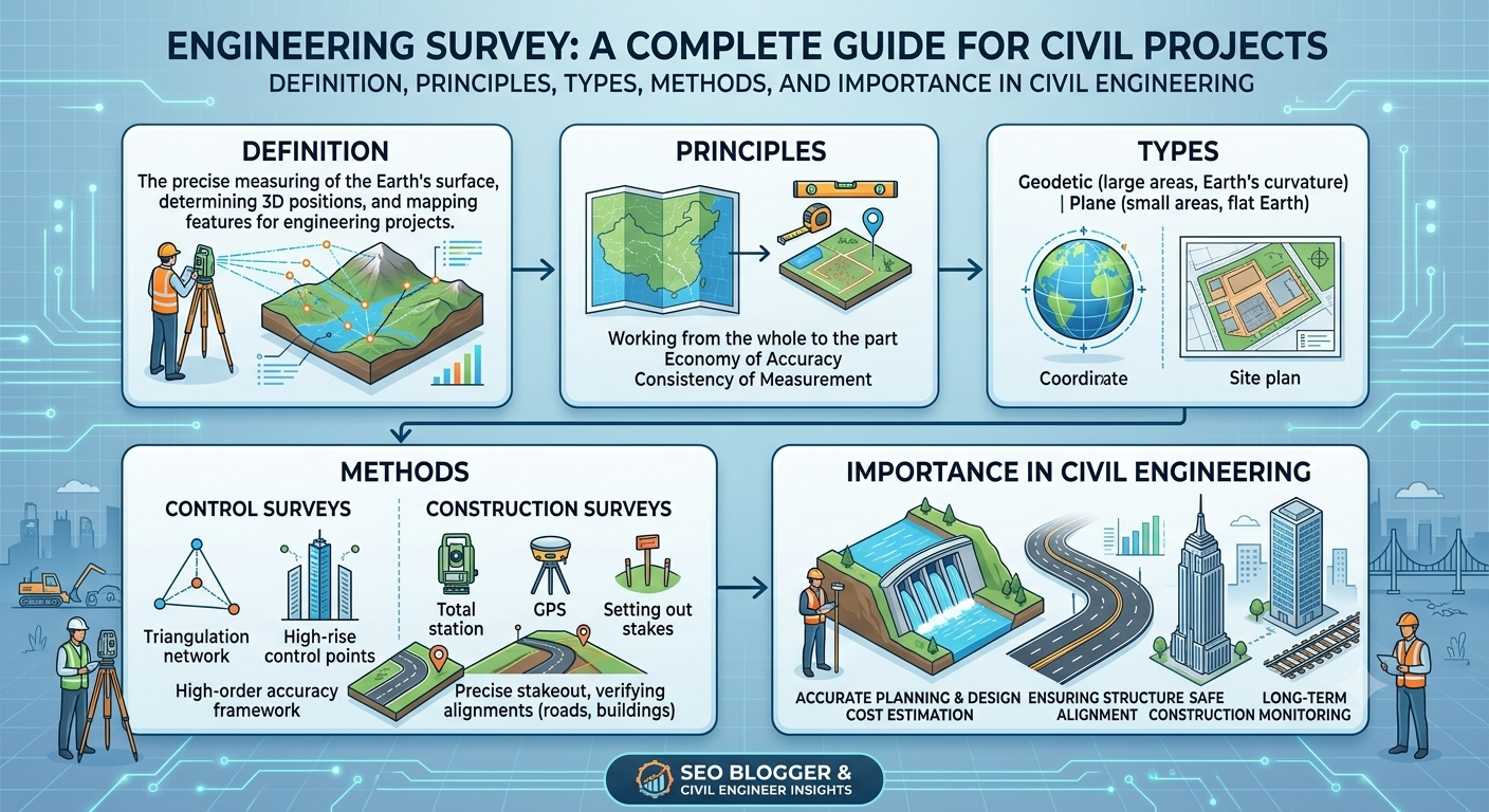
Engineering projects begin with accurate information about the land, existing structures, and surrounding environment. Whether the objective is constructing a highway, bridge, railway, dam, airport, or commercial building, engineers first need reliable field data before making design decisions. This is where an Engineering Survey becomes indispensable.
An engineering survey provides the measurements, coordinates, elevations, and physical characteristics required to transform design concepts into safe, efficient, and economically viable infrastructure. Without proper surveying, construction projects are more likely to experience alignment errors, drainage issues, structural defects, cost overruns, and project delays.
Modern engineering surveys combine traditional field techniques with advanced technologies such as Global Navigation Satellite Systems (GNSS), Total Stations, drones, laser scanners, and Geographic Information Systems (GIS). These innovations enable surveyors to produce highly accurate data while reducing time and improving productivity.
This comprehensive guide explains the fundamentals of Engineering Survey, including its objectives, principles, major types, commonly used equipment, and its significance in civil engineering projects.
What Is Engineering Survey?
An Engineering Survey is the process of measuring, mapping, and collecting physical information about a site to support the planning, design, construction, and maintenance of engineering projects. It establishes the exact horizontal and vertical positions of natural and features, ensuring that structures are built in the correct location and according to design specifications.
Unlike general land surveying, engineering surveying focuses specifically on infrastructure development. The collected data assists engineers in preparing accurate drawings, designing foundations, calculating earthwork quantities, and controlling construction activities.
Engineering Survey Provides Information About
- Ground elevations
- Property boundaries
- Existing roads and utilities
- Rivers and drainage channels
- Buildings and structures
- Topographical features
- Soil conditions
- Reference control points
Accurate survey data reduces uncertainty during design and helps prevent costly construction errors.
Why Engineering Survey Is Important
Every successful civil engineering project begins with reliable field measurements. Even a small surveying error can affect the alignment of roads, the positioning of bridges, or the stability of foundations.
Engineering surveys play a vital role throughout the project lifecycle, from the initial feasibility study to the final inspection after construction.
Key Benefits
- Ensures accurate project layout.
- Supports safe structural design.
- Reduces construction errors.
- Improves cost estimation.
- Minimizes material wastage.
- Enhances construction efficiency.
- Assists in quantity calculations.
- Facilitates legal compliance and land management.
For example, during highway construction, survey data determines the road centerline, pavement levels, drainage gradients, and curve geometry. Similarly, in bridge projects, precise measurements ensure that piers and abutments align correctly across the crossing.
Objectives of Engineering Survey
The primary purpose of an engineering survey is to provide dependable spatial information that enables engineers to make informed technical decisions.
Main Objectives
- Collect accurate field data.
- Establish horizontal and vertical control points.
- Prepare topographic maps.
- Support engineering design.
- Determine property boundaries.
- Calculate cut-and-fill quantities.
- Guide construction activities.
- Verify completed works.
- Monitor structural movement or settlement.
- Assist in maintenance and rehabilitation projects.
Meeting these objectives improves project quality while reducing construction risks and delays.
Principles of Engineering Survey
Engineering surveying follows two fundamental principles that ensure accuracy and consistency in measurements.
1. Working from Whole to Part
This principle involves establishing a network of highly accurate primary control points before surveying smaller areas in greater detail.
By fixing the main control framework first, errors are less likely to accumulate throughout the project.
Example:
When surveying a highway corridor, surveyors establish major control stations along the proposed alignment before locating culverts, utilities, and drainage structures.
Advantages
- Improves overall accuracy.
- Limits the spread of measurement errors.
- Simplifies quality control.
- Ensures consistent positioning across the project.
2. Fixing New Points by Two Independent Measurements
Every new survey point should be determined using at least two independent measurements or observations.
These measurements may include:
- Distance and angle
- Two angles
- Two distances
- GNSS observations
- Total Station coordinates
This principle allows surveyors to verify field data and identify mistakes before they affect the final design.
Types of Engineering Survey
Different engineering projects require different types of surveys. The selected method depends on the project stage, terrain, and required level of accuracy.
Reconnaissance Survey
A reconnaissance survey is the initial site inspection conducted before detailed measurements begin.
Its purpose is to gather general information about the project area and identify potential challenges.
Activities Include
- Visiting the proposed site
- Studying terrain conditions
- Identifying natural obstacles
- Locating existing infrastructure
- Assessing accessibility
- Selecting possible survey control points
This survey helps engineers determine the most suitable survey methods and equipment for the project.
Preliminary Survey
After reconnaissance, a preliminary survey collects more detailed information required for planning and feasibility studies.
Information Collected
- Topography
- Existing roads
- Drainage patterns
- Utility locations
- Ground elevations
- Preliminary alignments
The resulting data assists engineers in preparing conceptual designs and estimating project costs.
Detailed Survey
A detailed survey gathers highly accurate measurements used for final engineering design and construction drawings.
Data Typically Includes
- Horizontal coordinates
- Vertical elevations
- Property boundaries
- Utility mapping
- Existing structures
- Contours
- Surface features
This stage produces the information required to prepare detailed plans, cross-sections, profiles, and quantity estimates.
Construction Survey
Construction surveys, also known as setting-out surveys, transfer design information from drawings to the construction site.
Surveyors mark the exact locations where structures will be built.
Construction Survey Activities
- Establishing building corners
- Setting road centerlines
- Locating bridge foundations
- Marking excavation limits
- Positioning drainage structures
- Checking finished levels
Construction surveys continue throughout the project to verify that work complies with design specifications.
Equipment Used in Engineering Survey
Modern engineering surveying combines traditional instruments with advanced digital technologies.
Common Survey Equipment
Total Station
A Total Station measures horizontal angles, vertical angles, and distances while storing digital coordinates for later processing.
Automatic Level
Used to determine elevations and establish benchmarks for grading and construction.
GNSS/GPS Receiver
Provides accurate geographic coordinates using satellite positioning systems. It is widely used for large infrastructure and highway projects.
Drone (UAV)
Unmanned aerial vehicles capture high-resolution aerial imagery and generate digital terrain models for mapping and planning.
Laser Scanner
Produces dense three-dimensional point clouds, making it ideal for bridges, tunnels, industrial facilities, and complex structures.
Surveying Accessories
Additional tools include:
- Tripods
- Leveling staffs
- Prisms
- Measuring tapes
- Reflectors
- Range poles
- Pegs and markers
Selecting the appropriate equipment depends on project size, terrain, required accuracy, and budget.
Engineering Survey Workflow Diagram
Project Requirement
        │
        ▼
Reconnaissance Survey
        │
        ▼
Preliminary Survey
        │
        ▼
Detailed Survey
        │
        ▼
Engineering Design
        │
        ▼
Construction Survey
        │
        ▼
Quality Verification
This workflow illustrates how survey activities support every stage of an engineering project, from planning through construction.
Engineering Survey Process Step by Step
A systematic approach is essential for obtaining reliable survey data. Each stage builds on the previous one, ensuring that the final information accurately represents site conditions and supports safe engineering decisions.
Step 1: Define Project Requirements
Every survey begins by identifying the project’s objectives. Engineers determine the type of infrastructure, required accuracy, survey boundaries, deliverables, and applicable standards before fieldwork starts.
Typical activities include:
- Reviewing project drawings
- Understanding design requirements
- Identifying survey limits
- Selecting suitable survey methods
- Preparing a survey schedule
Step 2: Establish Survey Control Points
Control points form the reference framework for all measurements taken during the project. These permanent points ensure consistency throughout planning, design, and construction.
Surveyors establish:
- Horizontal control
- Vertical control
- Benchmarks
- Reference monuments
Accurate control networks reduce cumulative errors and improve overall survey reliability.
Step 3: Conduct Field Measurements
Once the control network is established, surveyors collect detailed field data using appropriate instruments.
Measurements commonly include:
- Distances
- Horizontal angles
- Vertical angles
- Elevations
- Coordinates
- Existing utilities
- Natural features
Modern equipment such as Total Stations, GNSS receivers, and drones significantly improves both accuracy and efficiency.
Step 4: Process and Verify Data
Raw field measurements are transferred to specialized software for processing and quality checks.
Engineers verify:
- Coordinate accuracy
- Closure errors
- Elevation consistency
- Instrument calibration records
- Missing observations
Errors identified during processing are corrected before final plans are prepared.
Step 5: Prepare Survey Drawings
After verification, survey data is converted into engineering drawings and digital models.
Deliverables may include:
- Topographic maps
- Contour plans
- Site layouts
- Cross-sections
- Longitudinal profiles
- Digital Terrain Models (DTMs)
- CAD drawings
These documents provide the foundation for engineering design.
Step 6: Construction Setting Out
The approved design is transferred to the construction site through setting-out operations.
Surveyors mark:
- Building corners
- Road centerlines
- Foundation locations
- Bridge pier positions
- Excavation limits
- Drainage alignments
Accurate setting out ensures the project is constructed exactly as designed.
Step 7: Final Verification Survey
After construction, a final survey confirms that completed works meet design specifications.
Verification includes checking:
- Alignment
- Levels
- Dimensions
- Structural locations
- Finished grades
Any deviations are documented before project completion.
Practical Applications of Engineering Survey
Engineering surveys are used throughout the construction industry because accurate measurements are essential for successful infrastructure development.
Highway Projects
Surveyors determine:
- Road centerlines
- Horizontal curves
- Vertical profiles
- Cross slopes
- Earthwork quantities
- Drainage layouts
Proper surveying improves ride quality and minimizes construction errors.
Railway Projects
Railway surveys establish:
- Track alignment
- Gradients
- Curvature
- Bridge locations
- Station positioning
High precision is essential because small alignment errors can significantly affect train safety and operating speeds.
Bridge Construction
Bridge surveys provide information required for:
- Foundation positioning
- Pier alignment
- Deck elevations
- River crossings
- Structural monitoring
Precise measurements ensure both sides of the bridge connect accurately during construction.
Building Projects
Surveying supports:
- Property boundary verification
- Foundation layout
- Column positioning
- Floor level control
- Structural alignment
Accurate layouts reduce costly rework during construction.
Dam and Reservoir Projects
Large hydraulic structures require extensive surveying for:
- Reservoir boundaries
- Water levels
- Spillway alignment
- Earth embankments
- Excavation quantities
Survey information helps engineers optimize both safety and storage capacity.
Airport Development
Engineering surveys assist with:
- Runway alignment
- Taxiway layout
- Drainage design
- Terminal construction
- Airfield grading
Because aviation infrastructure demands exceptional accuracy, advanced surveying technologies are commonly used.
Common Survey Errors and How to Avoid Them
Although modern equipment improves precision, errors can still occur if proper procedures are not followed.
Instrument Errors
These arise from:
- Poor calibration
- Damaged equipment
- Worn components
Prevention: Perform routine calibration and maintenance.
Human Errors
Examples include:
- Incorrect readings
- Improper instrument setup
- Recording mistakes
- Calculation errors
Prevention: Follow standardized procedures and verify measurements independently.
Natural Errors
Environmental conditions may affect measurements due to:
- Temperature variations
- Wind
- Atmospheric refraction
- Ground movement
Prevention: Conduct surveys during suitable weather conditions and apply necessary corrections.
Positioning Errors
Incorrect benchmark selection or unstable control points may reduce survey accuracy.
Prevention: Establish permanent, well-distributed control stations and verify coordinates regularly.
Best Practices for Engineering Survey
Successful engineering surveys follow disciplined procedures that prioritize precision, documentation, and quality assurance.
Recommended best practices include:
- Conduct reconnaissance before detailed measurements.
- Use calibrated and well-maintained instruments.
- Verify all control points before beginning fieldwork.
- Record field observations clearly and systematically.
- Perform independent checks on critical measurements.
- Store digital data securely with regular backups.
- Integrate GNSS, drones, and Total Stations where appropriate.
- Maintain effective communication between surveyors, designers, and contractors.
- Follow approved safety procedures during field operations.
- Review survey deliverables before releasing them for design or construction.
Practical Recommendations
Civil Engineers
- Review survey reports before starting design calculations.
- Coordinate closely with geotechnical and structural teams.
- Confirm control points before approving layouts.
- Use updated survey information throughout the project lifecycle.
Contractors
- Verify site layouts before excavation begins.
- Protect survey benchmarks during construction.
- Inform survey teams of design changes immediately.
- Conduct regular setting-out checks to avoid alignment issues.
Engineering Students
- Master the principles of leveling and traversing.
- Gain practical experience with Total Stations and GNSS receivers.
- Learn CAD and GIS software used for survey data processing.
- Visit construction sites to understand how survey data guides field activities.
- Develop strong skills in field note preparation and measurement verification.
General Discussion of IRC, AASHTO, and ICE Practices
International engineering organizations recognize surveying as a fundamental component of infrastructure development.
General guidance commonly emphasized includes:
- Establish reliable horizontal and vertical control networks before design.
- Perform detailed topographic and geotechnical surveys to support engineering decisions.
- Maintain survey accuracy appropriate to project requirements.
- Verify field measurements through independent observations.
- Preserve benchmarks and control points throughout construction.
- Integrate quality assurance into every stage of surveying.
- Utilize modern surveying technologies while maintaining sound engineering judgment.
- Keep comprehensive records for future maintenance and project documentation.
These widely accepted principles contribute to safer, more durable, and cost-effective infrastructure.
Frequently Asked Questions (FAQs)
1. What is an engineering survey?
An engineering survey is the process of measuring and mapping land, structures, and physical features to support the planning, design, construction, and maintenance of engineering projects.
2. Why is an engineering survey important?
It provides accurate site information that enables engineers to design safe, efficient, and economical infrastructure while reducing construction errors.
3. What are the main types of engineering surveys?
The major types include reconnaissance surveys, preliminary surveys, detailed surveys, and construction or setting-out surveys.
4. Which instruments are commonly used in engineering surveys?
Surveyors frequently use Total Stations, Automatic Levels, GNSS/GPS receivers, drones, laser scanners, measuring tapes, prisms, and leveling staffs.
5. What is the difference between a preliminary survey and a detailed survey?
A preliminary survey collects general information for planning, while a detailed survey gathers highly accurate measurements for final engineering design and construction.
6. How does engineering surveying improve construction quality?
Accurate surveying ensures that structures are built in the correct location, at the correct elevation, and according to approved design drawings.
7. What role does engineering surveying play in highway construction?
Surveying establishes road alignments, centerlines, elevations, drainage systems, and earthwork quantities required for safe and efficient highway construction.
8. How often should survey equipment be calibrated?
Calibration intervals depend on manufacturer recommendations, project requirements, and usage frequency, but instruments should always be checked before critical surveys.
9. Can drones replace traditional surveying methods?
Drones significantly improve data collection for large areas, but they complement rather than completely replace conventional surveying techniques, especially where high-precision control is required.
10. Which skills should aspiring survey engineers develop?
Students should focus on field measurements, instrument handling, CAD software, GIS applications, data processing, problem-solving, and communication skills.
Conclusion
An Engineering Survey is far more than a preliminary site activity—it is the cornerstone of every successful civil engineering project. Accurate survey data guides planning, supports detailed design, controls construction, and verifies completed works, making it essential for highways, railways, bridges, buildings, dams, airports, and other infrastructure. By applying sound surveying principles, using modern equipment, and following recognized engineering practices, professionals can minimize errors, improve construction quality, and reduce long-term project costs. Engineers, contractors, and students who understand the complete Engineering Survey process are better equipped to make informed decisions, manage risks, and deliver projects that meet technical, economic, and safety objectives. As surveying technology continues to evolve with GNSS, drones, laser scanning, and digital mapping, the importance of accurate field data will only increase, reinforcing the Engineering Survey as a fundamental discipline in modern civil and transportation engineering.

Kamran Malik is a passionate civil engineering writer and researcher who specializes in construction, transportation, structural engineering, and infrastructure topics. Through his articles on CivilEngineerings.com, he simplifies complex engineering concepts and shares practical insights, industry trends, and educational resources for students, professionals, and engineering enthusiasts.