
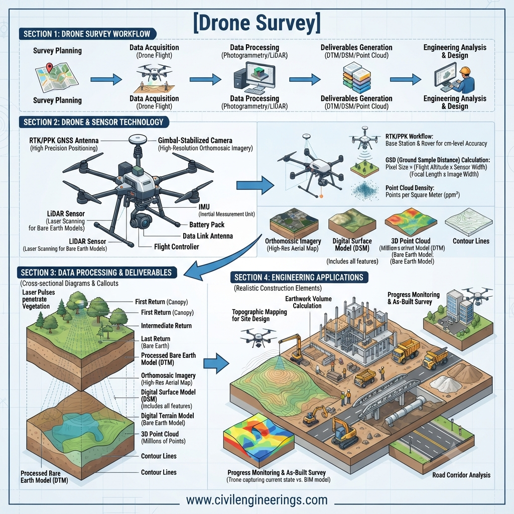
Introduction
Surveying has always been the foundation of successful civil engineering projects. Before constructing a highway, bridge, building, or dam, engineers must accurately measure the land and understand its physical characteristics. Traditionally, these tasks required extensive fieldwork, large survey teams, and considerable time. Today, technological advancements have transformed this process through Drone Survey technology.
A Drone Survey uses unmanned aerial vehicles (UAVs) equipped with high-resolution cameras, LiDAR systems, GPS receivers, and photogrammetry software to capture accurate spatial data from the air. The collected information is processed into maps, topographic models, digital terrain models (DTMs), orthomosaic images, and three-dimensional (3D) models that support planning, design, construction, and maintenance.
For road engineering projects, drone surveys significantly improve productivity by reducing field time, increasing data accuracy, and enhancing worker safety. They are now widely used during route selection, corridor mapping, earthwork estimation, construction monitoring, pavement inspections, and asset management.
Whether you are a civil engineer, contractor, surveyor, engineering student, or project manager, understanding Drone Survey techniques is essential for delivering modern infrastructure projects efficiently and accurately.
What Is a Drone Survey?
A Drone Survey is the process of collecting geographic and engineering data using an unmanned aerial vehicle (UAV) equipped with advanced sensors. The drone flies over the project site following a pre-planned route while capturing hundreds or thousands of overlapping images or laser measurements.
These data are processed using specialized software to generate highly accurate maps and models.
Unlike conventional surveying methods that rely heavily on total stations and GPS equipment, drone surveying enables engineers to cover large areas quickly while maintaining excellent accuracy.
Definition
A Drone Survey is an aerial surveying technique that uses UAVs, positioning technology, and digital imaging systems to create accurate topographic maps, terrain models, and engineering datasets for planning, design, construction, and monitoring.
Primary Objectives
- Capture accurate terrain data
- Reduce survey time
- Improve worker safety
- Produce detailed 3D models
- Support engineering decision-making
- Monitor construction progress
- Calculate earthwork volumes
Why Drone Surveying Is Transforming Civil Engineering
Infrastructure projects are becoming larger and more complex. Engineers require faster access to reliable data without compromising accuracy.
Drone surveying has emerged as one of the most valuable technologies in civil engineering because it combines speed, precision, and efficiency.
Key Advantages
- Rapid data collection
- High-resolution imagery
- Improved site safety
- Lower operational costs
- Reduced manpower requirements
- Accurate volume calculations
- Easy access to difficult terrain
For example, surveying a proposed 15-kilometre highway corridor using conventional methods may take several weeks. A drone survey can often capture the required aerial data within a few hours, depending on terrain, weather, and project complexity.
How a Drone Survey Works
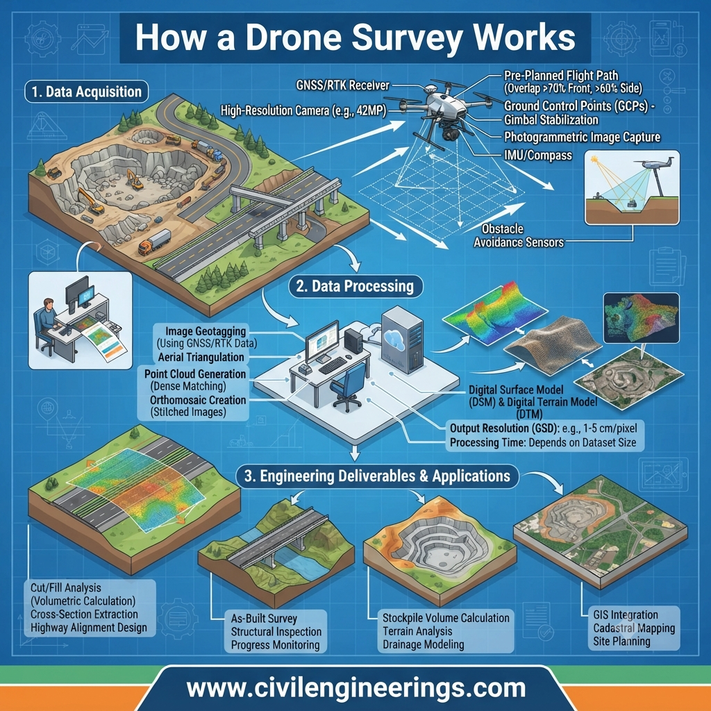
A drone survey follows a systematic workflow to ensure complete site coverage and reliable data.
The process begins by defining the survey area and planning the flight path. The drone then flies autonomously while collecting overlapping aerial photographs or LiDAR data.
Specialized software combines these datasets into accurate engineering products.
Simplified Workflow
Project Planning
        │
        ▼
Mission Planning
        │
        ▼
Ground Control Setup
        │
        ▼
Drone Flight
        │
        ▼
Image & Data Collection
        │
        ▼
Photogrammetry Processing
        │
        ▼
Maps • 3D Models • DTMs • Volume Reports
Every stage contributes to the overall quality and accuracy of the final survey deliverables.
Components of a Drone Survey System
A successful drone survey depends on several integrated components working together.
1. UAV (Drone)
The unmanned aerial vehicle is the platform that carries cameras and sensors over the project site.
Modern survey drones include:
- Multi-rotor drones
- Fixed-wing drones
- Hybrid VTOL drones
Each type is selected based on project size, terrain, and required flight duration.
2. Ground Control Station
The ground control station is where the survey operator plans the flight, monitors the drone, and manages data collection.
Typical functions include:
- Flight planning
- Live monitoring
- Battery management
- Emergency controls
- Data verification
Mission planning software allows engineers to define flight altitude, image overlap, flight speed, and camera settings before take-off.
3. Sensors and Cameras
The quality of a drone survey depends greatly on the sensor it carries.
Common sensors include:
RGB Cameras
Capture high-resolution colour photographs used for:
- Orthomosaic maps
- Site inspections
- Progress monitoring
- Surface modeling
LiDAR Sensors
LiDAR uses laser pulses to measure ground elevations accurately, even in areas with dense vegetation.
Applications include:
- Forest surveys
- Highway corridors
- Earthwork measurement
- Flood modeling
Multispectral Cameras
These cameras collect information beyond visible light and are useful for:
- Vegetation health analysis
- Environmental monitoring
- Land management
Thermal Cameras
Thermal imaging detects temperature differences and assists in:
- Infrastructure inspection
- Utility surveys
- Pavement condition assessments
- Leak detection
4. GPS/GNSS Receiver
Accurate positioning is essential for producing reliable survey data.
Modern survey drones use GPS or GNSS receivers to determine their location throughout the flight.
Many professional systems also support:
- RTK (Real-Time Kinematic)
- PPK (Post-Processed Kinematic)
These technologies significantly improve positional accuracy.
5. Photogrammetry Software
After the flight, captured images are processed using photogrammetry software.
The software automatically:
- Aligns overlapping images
- Creates point clouds
- Generates digital terrain models
- Produces orthomosaic maps
- Builds 3D surface models
- Calculates volumes
These outputs are commonly imported into CAD, GIS, and BIM platforms for engineering design.
Types of Drones Used in Surveying
Different projects require different drone platforms.
Multi-Rotor Drones
Advantages
- Excellent maneuverability
- Vertical take-off and landing
- High image quality
- Ideal for confined areas
Typical Applications
- Bridge inspections
- Building surveys
- Small construction sites
- Road intersections
Fixed-Wing Drones
Fixed-wing drones resemble small aircraft and are designed for covering large areas.
Advantages
- Long flight duration
- Greater coverage
- Higher operational efficiency
Applications
- Highway corridor surveys
- Pipeline mapping
- Transmission line inspection
- Regional topographic surveys
Hybrid VTOL Drones
Hybrid drones combine the vertical take-off capability of multi-rotor systems with the long-range efficiency of fixed-wing aircraft.
They are increasingly used for large infrastructure projects where operational flexibility is important.
Sensors Used in Drone Surveys
Selecting the appropriate sensor depends on the project’s objectives.
| Sensor Type | Primary Purpose |
|---|---|
| RGB Camera | Orthophotos and mapping |
| LiDAR | High-accuracy terrain mapping |
| Multispectral Camera | Vegetation analysis |
| Thermal Camera | Infrastructure inspection |
| Oblique Camera | 3D building modeling |
Using the correct sensor ensures that the collected data meets engineering requirements while minimizing unnecessary costs.
Applications of Drone Survey in Civil and Road Engineering
Drone surveys are now used throughout the lifecycle of infrastructure projects.
Highway Planning
- Route selection
- Corridor mapping
- Alignment studies
Construction Surveying
- Site grading
- Earthwork calculations
- Stockpile measurements
- Progress monitoring
Bridge Engineering
- Structural inspections
- Crack detection
- Clearance measurements
Pavement Engineering
- Surface condition assessment
- Rutting analysis
- Drainage evaluation
Mining and Quarrying
- Volume calculations
- Pit mapping
- Safety inspections
Urban Development
- Land development planning
- Utility mapping
- Smart city projects
Disaster Management
- Flood mapping
- Landslide assessment
- Emergency response planning
Benefits of Drone Survey
Drone surveying offers significant technical and economic advantages compared with many traditional methods.
Faster Data Collection
Large project areas can often be surveyed in a fraction of the time required by conventional ground surveys.
Improved Safety
Surveyors can collect information from hazardous locations without entering unstable slopes, busy highways, or inaccessible terrain.
High Accuracy
When combined with Ground Control Points (GCPs) or RTK/PPK positioning, drone surveys can achieve centimetre-level accuracy suitable for many engineering applications.
Cost Efficiency
Reduced field time, smaller survey teams, and faster project delivery contribute to lower overall surveying costs.
Better Visualization
Three-dimensional terrain models and orthomosaic maps provide engineers and stakeholders with a clearer understanding of site conditions.
Enhanced Decision-Making
Accurate aerial data supports informed decisions during planning, design, construction, and maintenance, helping reduce errors and improve project outcomes.
Drone Survey Process Step by Step
A successful Drone Survey requires careful planning, precise execution, and accurate data processing. Every stage contributes to the reliability of the final maps and engineering deliverables.
Step 1: Define the Survey Objectives
Every survey begins by identifying the project requirements. Engineers determine the purpose of the survey, expected accuracy, deliverables, and project timeline.
Typical objectives include:
- Topographic mapping
- Highway corridor surveys
- Earthwork volume calculations
- Construction progress monitoring
- Bridge inspections
- Digital terrain modeling (DTM)
Clearly defining the objectives helps select the appropriate drone, sensor, flight altitude, and processing workflow.
Step 2: Site Reconnaissance
Before flying the drone, the survey team visits the project site to assess existing conditions.
Important observations include:
- Terrain characteristics
- Trees and vegetation
- Buildings and structures
- Power transmission lines
- Mobile towers
- Weather conditions
- Restricted flight zones
- Safe take-off and landing locations
Proper reconnaissance minimizes operational risks and improves flight efficiency.
Step 3: Establish Ground Control Points (GCPs)
Ground Control Points (GCPs) are accurately surveyed reference markers placed across the project area. They improve the positional accuracy of aerial data and ensure reliable mapping results.
Best Practices for GCP Placement
- Distribute GCPs evenly across the survey area.
- Place markers on stable, visible surfaces.
- Survey GCP coordinates using high-precision GNSS equipment.
- Include checkpoints to verify final accuracy.
Projects requiring high engineering precision often combine GCPs with RTK or PPK technology.
Step 4: Flight Planning
Mission planning software is used to create an automated flight path before take-off.
Engineers define:
- Flight altitude
- Camera angle
- Image overlap
- Flight speed
- Survey boundaries
- Battery requirements
Proper flight planning ensures complete coverage while avoiding unnecessary image duplication.
Step 5: Data Collection
Once the mission begins, the drone follows the predefined route while capturing high-resolution images or LiDAR data.
The operator continuously monitors:
- Battery level
- Satellite connection
- Weather changes
- Image quality
- Flight stability
Consistent overlap between photographs is essential for accurate photogrammetric processing.
Step 6: Data Processing
After the flight, the collected images are imported into photogrammetry software.
The software automatically performs several tasks:
- Image alignment
- Point cloud generation
- Orthomosaic creation
- Digital Surface Model (DSM)
- Digital Terrain Model (DTM)
- Contour generation
- 3D model creation
Engineers review the outputs and correct any errors before preparing final deliverables.
Step 7: Quality Assurance and Reporting
The final stage involves verifying the survey results against project requirements.
Typical deliverables include:
- Orthomosaic maps
- Topographic maps
- Contour plans
- Digital terrain models
- Earthwork reports
- 3D surface models
- CAD-compatible files
- GIS datasets
These products support planning, design, construction, and long-term asset management.
Engineering Principles Behind Drone Survey
Drone surveying combines several engineering and scientific principles to produce accurate spatial information.
Photogrammetry
Photogrammetry uses overlapping photographs captured from different viewpoints to calculate the position and elevation of ground features.
The software identifies common points between images and reconstructs a three-dimensional representation of the terrain.
Global Navigation Satellite Systems (GNSS)
GNSS technology determines the precise position of the drone during flight.
Professional survey drones commonly support:
- GPS
- GLONASS
- Galileo
- BeiDou
Using multiple satellite constellations improves positioning reliability and accuracy.
Coordinate Systems
Survey data is referenced to established coordinate systems to ensure compatibility with engineering drawings and GIS databases.
This allows engineers to integrate drone survey results with existing project information.
Digital Terrain Modeling
Digital Terrain Models (DTMs) represent the bare-earth surface after removing vegetation and buildings from the dataset.
DTMs are widely used for:
- Road alignment design
- Drainage analysis
- Earthwork estimation
- Flood studies
Accuracy in Drone Survey
Accuracy is one of the most important considerations in engineering surveys. The final precision depends on several factors rather than the drone alone.
Factors Affecting Accuracy
- Camera resolution
- Flight altitude
- Image overlap
- GNSS quality
- Weather conditions
- Ground Control Points
- Sensor calibration
- Data processing techniques
Professional workflows are designed to minimize these sources of error and produce consistent, repeatable results.
RTK, PPK, and Ground Control Points
Modern survey systems often use advanced positioning methods to improve accuracy.
RTK (Real-Time Kinematic)
RTK provides real-time corrections during the flight, allowing the drone to record highly accurate positions immediately.
Advantages
- Faster processing
- High positional accuracy
- Reduced dependence on numerous GCPs
PPK (Post-Processed Kinematic)
PPK applies positioning corrections after the flight using recorded satellite data.
Advantages
- Reliable results in challenging signal environments
- Greater flexibility during field operations
- High accuracy for engineering projects
Ground Control Points (GCPs)
Although RTK and PPK improve positioning, Ground Control Points remain valuable for validating survey accuracy, particularly on large or high-precision projects.
Limitations of Drone Survey
Despite its many advantages, drone surveying also has certain limitations.
Weather Dependency
Strong winds, heavy rain, fog, or poor visibility can delay flights and reduce image quality.
Battery Life
Most survey drones have limited flight durations, requiring careful mission planning and battery management.
Regulatory Restrictions
Drone operations must comply with national aviation regulations, including flight permissions, altitude limits, and no-fly zones.
Dense Vegetation
Standard cameras may struggle to capture the ground beneath thick vegetation. In such conditions, LiDAR sensors are often preferred.
Data Processing Requirements
High-resolution surveys generate large datasets that require powerful computers and specialized software for efficient processing.
Best Practices for Drone Survey
Following recognized best practices helps achieve reliable, repeatable, and high-quality survey results.
- Conduct a detailed pre-flight inspection.
- Check weather forecasts before every mission.
- Calibrate cameras and sensors regularly.
- Maintain adequate image overlap.
- Use Ground Control Points for engineering-grade accuracy.
- Verify GNSS signal quality before take-off.
- Follow approved flight plans.
- Perform quality checks after data processing.
- Archive raw survey data securely.
- Comply with local aviation regulations and site safety procedures.
Practical Recommendations
Civil Engineers
- Integrate drone surveys into the planning and design phases to reduce rework.
- Compare aerial survey data with ground verification where critical measurements are required.
- Use drone-generated terrain models to improve earthwork estimation and drainage design.
Contractors
- Monitor construction progress with scheduled drone flights.
- Use orthomosaic maps to verify completed work.
- Track stockpile quantities and material movement using aerial data.
Engineering Students
- Learn the basics of photogrammetry and GIS.
- Understand flight planning principles before operating survey drones.
- Practice interpreting orthomosaic maps, contour plans, and digital terrain models.
- Stay informed about drone regulations and ethical data collection practices.
General Discussion of IRC, AASHTO, and ICE Practices
Leading engineering organizations recognize the value of accurate surveying and geospatial data in infrastructure development. While project-specific requirements differ, the following principles are widely supported:
- Use reliable survey data as the foundation for highway planning and design.
- Verify positional accuracy before construction begins.
- Employ modern surveying technologies where appropriate to improve efficiency.
- Maintain comprehensive quality assurance procedures throughout the survey process.
- Ensure proper documentation and data management for future reference.
- Integrate survey results with design, construction, and maintenance workflows.
These general practices align with the objectives commonly emphasized in IRC, AASHTO, and ICE guidance for infrastructure projects.
Future of Drone Surveying
The future of drone surveying is being shaped by rapid technological advancements.
Emerging developments include:
- Artificial intelligence for automated feature extraction
- Real-time cloud-based data processing
- Autonomous flight missions
- Improved LiDAR technology
- Digital twin integration
- Building Information Modeling (BIM) compatibility
- Machine learning for infrastructure inspections
As these technologies mature, drone surveys are expected to become even faster, more accurate, and more integrated into everyday engineering practice.
Frequently Asked Questions (FAQs)
1. What is a Drone Survey?
A Drone Survey is an aerial surveying method that uses UAVs equipped with cameras or sensors to collect spatial data for mapping, modeling, and engineering analysis.
2. How accurate is a Drone Survey?
When supported by Ground Control Points or RTK/PPK positioning, a Drone Survey can achieve centimetre-level accuracy suitable for many civil engineering applications.
3. What is the difference between drone surveying and traditional surveying?
Traditional surveying relies primarily on ground-based instruments, while drone surveying captures aerial data quickly over large areas, improving efficiency and site safety.
4. Which industries commonly use Drone Surveys?
Drone surveys are widely used in civil engineering, road construction, mining, agriculture, environmental management, utilities, urban planning, and disaster response.
5. What software is used to process drone survey data?
Photogrammetry software processes aerial images to create orthomosaics, point clouds, digital terrain models, contour maps, and 3D models. The processed outputs are often integrated into CAD, GIS, or BIM platforms.
6. Can Drone Surveys be used for highway projects?
Yes. They are commonly used for corridor mapping, route selection, topographic surveys, earthwork estimation, construction monitoring, pavement inspections, and asset management.
7. What are Ground Control Points (GCPs)?
Ground Control Points are precisely surveyed reference markers used to improve the positional accuracy of drone-generated maps and models.
8. What factors affect Drone Survey accuracy?
Key factors include flight altitude, image overlap, camera quality, GNSS positioning, Ground Control Points, weather conditions, sensor calibration, and data processing techniques.
9. Is a Drone Survey suitable for small construction sites?
Yes. Multi-rotor drones are particularly effective for surveying small and medium-sized construction sites, providing rapid data collection and detailed visual documentation.
10. What skills should future survey engineers develop?
Survey engineers should understand UAV operations, photogrammetry, GNSS principles, GIS, CAD integration, data processing, and relevant aviation regulations to remain competitive in modern infrastructure projects.
Conclusion
Drone Survey technology has revolutionized the way civil engineers, surveyors, and contractors collect and analyze spatial data. By combining unmanned aerial vehicles, advanced sensors, GNSS positioning, and photogrammetry software, it delivers fast, accurate, and cost-effective survey results for projects of all sizes. From highway corridor planning and earthwork calculations to bridge inspections and construction monitoring, drone surveys improve decision-making, enhance safety, and increase project efficiency. As infrastructure projects become more complex, the demand for reliable aerial surveying solutions will continue to grow. Engineers who understand Drone Survey principles, follow industry best practices, and adopt emerging technologies such as RTK, LiDAR, BIM integration, and AI-assisted analysis will be better equipped to deliver high-quality, sustainable infrastructure. Whether you are a practicing engineer, contractor, student, or project manager, mastering Drone Survey techniques is an investment in the future of modern civil and road engineering.

Kamran Malik is a passionate civil engineering writer and researcher who specializes in construction, transportation, structural engineering, and infrastructure topics. Through his articles on CivilEngineerings.com, he simplifies complex engineering concepts and shares practical insights, industry trends, and educational resources for students, professionals, and engineering enthusiasts.