
Introduction
Accurate surveying is the foundation of every successful civil engineering and road infrastructure project. Before engineers can design and construct highways, bridges, railways, buildings, or pipelines, they must collect precise field data that represents the actual ground conditions. Among the many surveying techniques available, the Traverse Survey is one of the most reliable methods for establishing horizontal control and determining the relative positions of points over a project site.
A traverse survey creates a connected series of survey lines by carefully measuring their lengths and directions. This method enables surveyors to map land boundaries, establish construction control points, locate engineering structures, and prepare topographic maps with a high degree of accuracy.Engineers widely use traverse surveying in highway engineering, route alignment, property surveys, utility projects, and urban development because of its flexibility and precision.
Whether you are a civil engineering student learning the fundamentals of surveying or a practicing engineer responsible for layout work, understanding the principles and procedures of Traverse Survey is essential. This guide explains the concept in a practical, engineering-focused manner while highlighting best practices used in modern surveying projects.
What Is Traverse Survey?
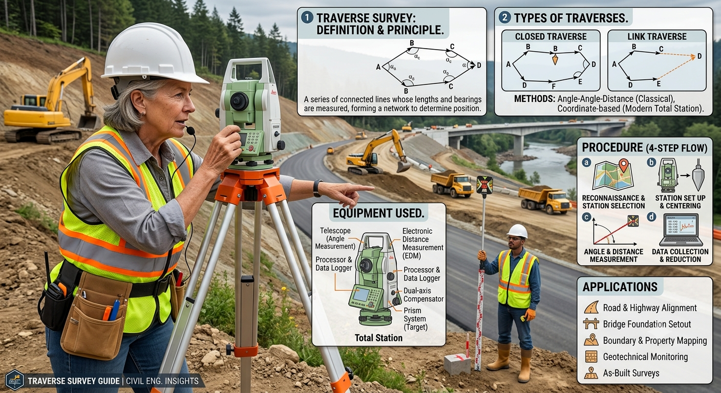
In a Traverse Survey, surveyors establish a method of horizontal surveying by measuring both the length and direction of a series of connected survey linesA Traverse Survey is a method of horizontal surveying in which surveyors establish a series of connected survey lines by measuring both the length and direction of each line. These connected lines form a traverse that allows surveyors to calculate the positions of unknown points accurately.
Each traverse consists of survey stations connected by straight lines.Surveying equipment measures the distance between stations, while surveyors determine the direction through horizontal angles or bearings. Once field observers complete their observations, they perform mathematical calculations to determine the coordinates of each station.
Unlike simple chain surveying, traverse surveying is suitable for large and irregular areas where high precision is required. It provides a strong control framework for engineering design, construction layout, and mapping projects.
Key Characteristics
- Measures both distances and horizontal angles.
- Establishes horizontal control points.
- Suitable for small and large engineering projects.
- Offers higher accuracy than basic surveying methods.
- Can be adjusted mathematically to improve precision.
Objectives of Traverse Survey
The primary purpose of a traverse survey is to establish a network of accurately positioned points that can serve as a reference for future engineering work.
Main Objectives
- Establish horizontal control for construction projects.
- Determine the coordinates of unknown locations.
- Prepare topographic and engineering maps.
- Survey property and land boundaries.
- Support highway and railway alignment.
- Locate utilities and infrastructure.
- Provide reference points for detailed surveys.
- Assist in construction setting out.
Importance in Civil Engineering
In road engineering, a traverse survey provides the control network used to fix the centerline of a proposed highway. It also helps engineers position culverts, bridges, retaining walls, and drainage structures accurately according to design drawings.
Engineering Principles of Traverse Survey
The reliability of a traverse survey depends on several fundamental surveying principles.
Measurement of Distance
Each survey line must be measured accurately using appropriate instruments such as tapes, Electronic Distance Measurement (EDM) devices, or total stations.
Measurement of Direction
The direction of each traverse line is determined by measuring horizontal angles or bearings relative to a reference direction, typically true north or magnetic north.
Coordinate Computation
Using measured distances and directions, surveyors calculate the coordinates of every station through trigonometric relationships.
Closure Check
For closed traverses, the calculated ending point should coincide with the known starting point. Any discrepancy is called the closing error, which is adjusted using accepted surveying methods.
Engineering Principle
The greater the accuracy of field measurements, the smaller the closing error and the more reliable the survey results.
Types of Traverse Survey
Traverse surveys are generally classified into two main categories depending on whether the traverse forms a closed loop.
1. Open Traverse
An Open Traverse begins at one known station and ends at another unknown station without returning to the starting point.
Characteristics
- Does not form a closed polygon.
- Closure cannot be checked directly.
- Suitable for route surveys.
- Commonly used for highways, canals, pipelines, and transmission lines.
Advantages
- Simple to perform.
- Ideal for linear infrastructure projects.
- Requires fewer observations than a closed traverse.
Limitations
- Errors accumulate along the traverse.
- Accuracy is lower because closure cannot be verified mathematically.
Open Traverse Diagram
Station A -------- Station B -------- Station C -------- Station D
This type of traverse is commonly adopted during preliminary highway alignment surveys where the route extends continuously in one direction.
2. Closed Traverse
A Closed Traverse starts and ends at the same station or connects two stations with known coordinates, forming a closed geometric figure.
Characteristics
- Forms a complete loop.
- Allows error detection.
- Enables mathematical adjustment.
- Provides higher surveying accuracy.
Advantages
- Greater reliability.
- Easy error checking.
- Suitable for property surveys.
- Preferred for construction control networks.
Closed Traverse Diagram
           A
         /   \
       B       D
         \   /
           C
Because the traverse closes on itself, surveyors can verify the measurements by comparing calculated and known coordinates.
Equipment Used in Traverse Survey
Modern traverse surveying combines traditional methods with advanced digital instruments.
Essential Equipment
Total Station
A total station measures both angles and distances electronically while storing field data digitally. It is the most widely used instrument in contemporary engineering surveys.
Theodolite
Used for precise measurement of horizontal and vertical angles. It remains valuable where electronic equipment is unavailable.
Electronic Distance Measurement (EDM)
Measures distances rapidly and accurately using electromagnetic waves.
Measuring Tape
Steel or fiberglass tapes are still used for short-distance measurements and equipment checks.
Tripod
Provides a stable platform for surveying instruments.
Prism and Prism Pole
Reflect EDM signals back to the total station for accurate distance measurement.
Survey Pegs and Ranging Rods
Used to mark survey stations and maintain alignment during fieldwork.
GPS/GNSS Receiver
Modern surveys often integrate satellite positioning systems to establish initial control points efficiently.
Step-by-Step Traverse Survey Procedure
A systematic procedure ensures that the collected field data is accurate and reliable.
Step 1: Reconnaissance
Surveyors visit the site to:
- Study terrain conditions.
- Select suitable traverse stations.
- Identify obstacles.
- Plan survey operations.
Step 2: Establish Traverse Stations
Stations are positioned where clear visibility exists between consecutive points. Proper spacing minimizes measurement errors.
Step 3: Instrument Setup
The total station or theodolite is centered and leveled accurately over the first station before observations begin.
Step 4: Measure Horizontal Angles
Horizontal angles between successive traverse lines are observed carefully. Multiple readings may be taken to improve accuracy.
Step 5: Measure Distances
Distances between stations are measured using EDM equipment or total stations.
Step 6: Record Field Observations
All observations are entered into field books or digital data collectors, including:
- Station identification
- Angles
- Distances
- Instrument heights
- Weather conditions (if required)
Step 7: Compute Coordinates
Office calculations determine the coordinates of each traverse station using measured distances and bearings.
Step 8: Check Traverse Closure
For closed traverses, surveyors calculate the closing error and apply suitable adjustment methods before preparing final plans.
Practical Example
A highway project requires establishing control points for a proposed bypass road. Engineers select a series of traverse stations along the preliminary alignment and measure the distance and bearing between each station using a total station.
The resulting coordinates become the reference framework for:
- Highway centerline layout
- Earthwork calculations
- Bridge positioning
- Culvert installation
- Utility relocation
- Drainage design
Because accurate control points are established at the beginning, all subsequent construction activities can be completed with confidence and precision.
Topic-Related Diagrams
Basic Traverse Survey Layout
A -------- B -------- C -------- D
 \                      |
  \                     |
   ---------------------E
Components of a Traverse Survey
Survey Station
      ●
      │
Distance Measured
      │
      ▼
Next Survey Station
      ●

Angle Measured at Every Station
Workflow of a Traverse Survey
Reconnaissance
      │
      ▼
Station Selection
      │
      ▼
Instrument Setup
      │
      ▼
Measure Angles
      │
      ▼
Measure Distances
      │
      ▼
Coordinate Computation
      │
      ▼
Closure Check
      │
      ▼
Final Traverse Plan
Applications of Traverse Survey in Civil and Road Engineering
The Traverse Survey is one of the most widely used surveying methods in civil engineering because it provides accurate horizontal control for projects of varying sizes. Its flexibility makes it suitable for both preliminary investigations and detailed construction activities.
1. Highway and Expressway Projects
Traverse surveys are extensively used during highway planning and construction. Engineers establish control points along the proposed alignment, which serve as reference locations for road centerlines, curves, bridges, culverts, retaining walls, and drainage structures.
Practical Example:
During the construction of a four-lane highway, surveyors establish traverse stations at regular intervals. These stations guide excavation, embankment formation, pavement construction, and utility relocation with high accuracy.
2. Railway Alignment
Railway engineers rely on traverse surveys to establish accurate track alignments, especially where long-distance routes pass through varying terrain.
3. Property and Boundary Surveys
Traverse surveying is commonly used to determine land boundaries for residential, commercial, and industrial developments. Closed traverses are particularly suitable because they allow mathematical verification of survey accuracy.
4. Urban Infrastructure Development
Municipal engineering projects frequently use traverse surveys for:
- Road widening
- Sewer networks
- Water supply pipelines
- Stormwater drainage
- Utility corridors
- Smart city infrastructure
5. Bridge and Tunnel Projects
Before bridge foundations or tunnel portals are constructed, engineers establish accurate control networks using traverse surveys to ensure proper positioning.
6. Construction Layout
Traverse stations provide reference coordinates for:
- Buildings
- Retaining walls
- Foundations
- Industrial plants
- Airport runways
- Dams
Advantages of Traverse Survey
The popularity of traverse surveying is due to its accuracy, adaptability, and suitability for engineering applications.
Major Advantages
- Provides highly accurate horizontal control.
- Suitable for both small and large projects.
- Works well on irregular terrain.
- Can be extended over long distances.
- Supports detailed mapping.
- Easily integrated with Total Station and GPS technology.
- Mathematical adjustments improve reliability.
- Requires fewer control points than grid surveys.
- Ideal for route surveys and engineering design.
Limitations of Traverse Survey
Although traverse surveying offers many benefits, engineers should also understand its limitations.
Common Limitations
- Open traverses cannot be checked for closure directly.
- Measurement errors accumulate if observations are inaccurate.
- Requires skilled surveyors for precise angle measurements.
- Dense vegetation and obstructed sightlines may reduce efficiency.
- Instrument calibration is essential for reliable results.
- Weather conditions can affect observations.
- Poor station selection increases the likelihood of errors.
Understanding these limitations helps survey teams plan field operations more effectively.
Common Errors in Traverse Survey
Even experienced surveyors encounter measurement errors. Identifying and correcting these errors is critical for maintaining survey accuracy.
Instrumental Errors
These occur because of equipment imperfections.
Examples include:
- Improper instrument calibration
- Collimation errors
- Tape length variations
- EDM calibration issues
Prevention
- Perform regular calibration.
- Inspect instruments before fieldwork.
- Follow manufacturer maintenance schedules.
Personal Errors
Human mistakes often contribute to survey inaccuracies.
Examples include:
- Incorrect readings
- Poor leveling
- Misidentification of stations
- Recording mistakes
Prevention
- Double-check all observations.
- Use experienced survey teams.
- Verify field notes before leaving the site.
Natural Errors
Environmental conditions also influence survey measurements.
Examples include:
- Temperature variations
- Wind
- Atmospheric refraction
- Magnetic disturbances
- Poor visibility
Prevention
- Schedule surveys during favorable weather.
- Apply necessary corrections where applicable.
- Avoid observations during extreme environmental conditions.
Traverse Adjustment Methods
When a closed traverse does not return exactly to its starting point, the resulting misclosure must be adjusted mathematically.
Common adjustment methods include:
Bowditch (Compass) Rule
Used when both angle and distance measurements have similar precision. Corrections are distributed proportionally according to traverse lengths.
Transit Rule
Applied when angular measurements are more accurate than linear measurements.
Least Squares Adjustment
Widely used in modern surveying software for high-precision engineering projects. This method minimizes the overall effect of random errors and provides statistically optimized coordinates.
Proper adjustment ensures that calculated coordinates satisfy geometric closure while maintaining survey integrity.
Best Practices for Traverse Survey
Following proven engineering practices improves both accuracy and efficiency.
Planning
- Conduct a thorough reconnaissance before starting.
- Select stations with clear intervisibility.
- Avoid unstable ground where possible.
Equipment
- Calibrate instruments before use.
- Use stable tripods.
- Verify prism constants and EDM settings.
Field Observations
- Measure angles more than once.
- Check distances using independent observations where practical.
- Record data immediately to avoid transcription errors.
Data Processing
- Review field notes carefully.
- Perform closure calculations promptly.
- Apply appropriate adjustment methods.
- Validate final coordinates before construction begins.
Practical Recommendations
Civil Engineers
- Establish permanent control points before detailed design.
- Integrate traverse data with GIS and CAD software.
- Verify survey results before approving construction layouts.
Contractors
- Protect survey monuments during construction.
- Re-establish damaged control points immediately.
- Coordinate closely with survey teams before earthworks begin.
Surveyors
- Follow standardized observation procedures.
- Maintain calibration records for all instruments.
- Perform independent checks whenever possible.
Engineering Students
- Practice coordinate calculations manually before relying on software.
- Understand the difference between bearings, azimuths, and interior angles.
- Gain hands-on experience with Total Stations and GNSS equipment.
- Study real engineering projects to understand how traverse surveys support construction.
General Discussion of IRC, AASHTO, and ICE Practices
Leading engineering organizations such as IRC (Indian Roads Congress), AASHTO (American Association of State Highway and Transportation Officials), and the Institution of Civil Engineers (ICE) emphasize the importance of accurate surveying during the planning and construction of transportation infrastructure.
Although their standards differ in detail, they generally recommend:
- Establishing reliable horizontal control before detailed design.
- Performing comprehensive field reconnaissance.
- Using calibrated surveying instruments.
- Verifying measurements through independent checks.
- Applying recognized adjustment methods to closed traverses.
- Maintaining complete survey documentation.
- Integrating quality assurance procedures throughout the surveying process.
- Using modern technologies such as Total Stations, GNSS, and digital data collection to improve efficiency and accuracy.
These principles help ensure that engineering projects are built on dependable spatial data and meet the required levels of safety and precision.
Frequently Asked Questions (FAQs)
1. What is a Traverse Survey?
A Traverse Survey is a horizontal surveying method in which connected survey lines are established by measuring their lengths and directions to determine the positions of control points accurately.
2. What is the difference between an open and a closed traverse?
An open traverse does not return to the starting point and is commonly used for route surveys. A closed traverse forms a complete loop or connects known control points, allowing measurement errors to be checked and adjusted.
3. Why is Traverse Survey important in road construction?
Traverse surveys establish accurate control points for highway alignments, bridges, culverts, drainage systems, and pavement layout, ensuring that construction follows the approved design.
4. Which instruments are commonly used in Traverse Survey?
Modern surveys typically use Total Stations, Electronic Distance Measurement (EDM) devices, GNSS receivers, theodolites, prisms, tripods, and ranging rods.
5. What is traverse misclosure?
Traverse misclosure is the difference between the calculated and expected ending position of a closed traverse. It results from unavoidable measurement errors and is corrected using adjustment methods.
6. Which adjustment method is most commonly used?
The Bowditch (Compass) Rule is widely used when angle and distance measurements have comparable precision. High-accuracy projects often employ Least Squares Adjustment.
7. Can GPS replace Traverse Survey?
GNSS technology enhances modern surveying, but traverse surveys remain essential for construction control, high-precision layouts, and projects where satellite signals are obstructed.
8. What factors affect the accuracy of a Traverse Survey?
Accuracy depends on instrument calibration, surveyor skill, station selection, observation techniques, environmental conditions, and proper data adjustment.
9. Why are closed traverses preferred for engineering projects?
Closed traverses allow surveyors to detect and correct measurement errors, providing greater confidence in the calculated coordinates.
10. What software is commonly used to process traverse data?
Survey professionals often use CAD software, GIS platforms, and specialized surveying applications to compute coordinates, adjust traverses, and prepare engineering drawings.
Conclusion
A Traverse Survey is one of the most dependable and widely adopted surveying techniques in civil engineering, offering the accuracy and flexibility needed for modern infrastructure projects. By measuring connected survey lines and establishing reliable control points, it supports everything from highway alignment and land development to bridge construction and utility installation. Successful traverse surveying depends on careful planning, precise field observations, proper instrument calibration, and systematic error adjustment. Advances in Total Stations, GNSS technology, and digital surveying software have further improved the speed and precision of this method, yet the core surveying principles remain unchanged. Engineers, contractors, surveyors, and students who understand Traverse Survey techniques are better equipped to produce accurate layouts, minimize construction errors, and deliver projects that meet professional engineering standards. Mastering this essential surveying method strengthens the foundation of every successful civil engineering project and contributes to safer, more efficient, and more sustainable infrastructure development.
