
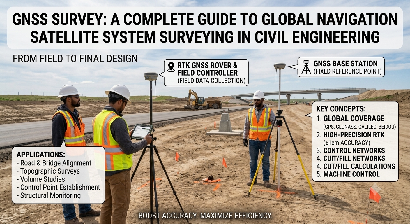
Modern infrastructure projects demand high levels of accuracy, efficiency, and reliability. Whether constructing a highway, bridge, railway, airport, or commercial building, engineers rely on precise positioning data to ensure every structure is built according to design. This is where GNSS Survey technology has transformed the surveying profession. By using satellite-based positioning systems, surveyors can determine accurate coordinates in real time, significantly reducing fieldwork while improving productivity.
Compared with conventional surveying methods, GNSS surveying provides faster data collection, greater flexibility, and improved accuracy over large project areas. It has become an essential tool for civil engineers, road engineers, land surveyors, contractors, and infrastructure consultants worldwide.
This comprehensive guide explains the fundamentals of GNSS Survey, including its working principles, system components, survey types, engineering applications, advantages, and industry best practices. Whether you are an engineering student or an experienced professional, understanding GNSS technology will help you deliver more accurate and efficient surveying results.
What is GNSS Survey?
A GNSS Survey is a positioning method that uses signals transmitted by multiple navigation satellites to determine the precise location of points on or near the Earth’s surface. GNSS stands for Global Navigation Satellite System, a collective term for satellite constellations that provide positioning, navigation, and timing services.
Unlike traditional land surveying, which often depends on intervisibility between survey stations, GNSS surveying calculates positions directly from satellites orbiting the Earth. This capability enables surveyors to work efficiently across extensive areas without establishing numerous control points.
The technology is widely used for:
- Highway alignment surveys
- Topographic mapping
- Boundary surveys
- Construction layout
- Bridge positioning
- Railway projects
- Utility mapping
- Earthwork quantity calculations
- GIS data collection
Because of its versatility and accuracy, GNSS surveying has become a standard practice in modern civil engineering projects.
Why GNSS Survey is Important
Surveying is the foundation of every engineering project. Even small positioning errors can lead to costly design modifications, construction delays, or structural problems.
GNSS technology addresses these challenges by providing:
- High positional accuracy
- Faster field data collection
- Reduced manpower requirements
- Improved productivity
- Consistent coordinate systems
- Reliable results over long distances
For highway and road engineering projects, accurate positioning is essential for establishing centerlines, setting out curves, locating drainage structures, and verifying completed work. GNSS surveying simplifies these tasks while improving overall project efficiency.
How GNSS Survey Works
GNSS surveying relies on a network of satellites that continuously transmit radio signals to receivers on the ground. By measuring the travel time of these signals, the receiver calculates its position using trilateration.
Understanding Satellite Positioning
Each satellite broadcasts information including:
- Satellite position
- Signal transmission time
- Orbital data
- System clock information
A GNSS receiver captures signals from multiple satellites simultaneously. Using distance measurements from at least four satellites, it computes its three-dimensional coordinates.
Coordinate Calculation
The receiver determines:
- Latitude
- Longitude
- Elevation
- Time
These coordinates are referenced to a global geodetic datum and can later be transformed into local coordinate systems used for engineering projects.
Data Processing
Depending on the survey method, positional data may be:
- Calculated instantly (Real-Time Kinematic)
- Processed after fieldwork (Post-Processed Kinematic)
- Combined with correction data from a reference station to improve accuracy
This flexibility allows GNSS surveying to meet the accuracy requirements of different engineering applications.
Components of a GNSS Survey System
A complete GNSS survey system consists of several interconnected components working together to produce accurate positioning data.
1. Satellites
Navigation satellites orbit the Earth and continuously transmit timing and positioning signals. Modern GNSS receivers can utilize signals from multiple constellations, improving satellite availability and measurement reliability.
2. GNSS Receiver
The receiver collects satellite signals and calculates the user’s position. Modern receivers are capable of tracking multiple frequencies and satellite systems simultaneously.
3. GNSS Antenna
The antenna receives satellite signals with minimal interference. High-quality antennas help reduce multipath effects and improve measurement precision.
4. Base Station
A base station is installed at a known coordinate and continuously transmits correction data to rover receivers. These corrections significantly improve positional accuracy.
5. Rover Receiver
The rover is the mobile receiver carried by the surveyor. It receives satellite signals along with correction data from the base station or network, enabling precise field measurements.
6. Data Collector
The data collector stores observations, displays coordinates in real time, and allows surveyors to manage survey points, coding, and field notes efficiently.
Types of GNSS Survey
Different project requirements call for different GNSS surveying techniques.
Static GNSS Survey
Static surveying involves placing receivers at fixed positions for an extended period. It provides the highest level of accuracy and is commonly used for establishing geodetic control networks.
Typical Applications
- National control points
- Large engineering projects
- Dam monitoring
- Bridge control surveys
Rapid Static Survey
Rapid static surveying reduces observation time while maintaining high accuracy. It is suitable for projects requiring multiple control points over moderate distances.
Common Uses
- Engineering control
- Property surveys
- Utility mapping
Kinematic Survey
In kinematic surveying, the receiver moves continuously while recording positions. This method is useful for mapping roads, railways, and pipelines where numerous points are required along a route.
Real-Time Kinematic (RTK) Survey
RTK surveying provides centimeter-level accuracy in real time by using correction data from a nearby base station or continuously operating reference station (CORS) network.
Advantages of RTK
- Immediate coordinate results
- High precision
- Faster construction staking
- Efficient topographic surveys
Because of its speed and accuracy, RTK has become one of the most widely used GNSS surveying methods in road and highway construction.
Post-Processed Kinematic (PPK) Survey
PPK surveying stores raw satellite observations during fieldwork. The data is processed later using specialized software to achieve highly accurate results.
This method is particularly useful where real-time correction signals are unavailable or unreliable.
Applications of GNSS Survey in Civil Engineering
GNSS surveying supports a wide range of engineering activities across different project phases.
Transportation Engineering
- Highway alignment
- Road centerline surveys
- Intersection layout
- Earthwork monitoring
Building Construction
- Building positioning
- Foundation layout
- Structural monitoring
- Site grading
Bridge Engineering
- Pier location
- Deck alignment
- Structural deformation monitoring
Railway Engineering
- Track alignment
- Corridor mapping
- Elevation control
Water Resources Engineering
- Canal surveys
- Dam monitoring
- Reservoir mapping
- Floodplain surveys
Utility Engineering
- Pipeline alignment
- Power transmission corridors
- Underground utility mapping
The ability to deliver accurate coordinates quickly makes GNSS surveying indispensable for modern infrastructure development.
Advantages of GNSS Survey
GNSS surveying offers several advantages over conventional surveying techniques.
- High positional accuracy
- Rapid data collection
- Reduced field crew size
- Long-range coverage
- Minimal requirement for intervisibility
- Increased productivity
- Digital data integration
- Easy compatibility with GIS and CAD software
- Lower long-term project costs
- Improved safety in difficult terrain
These benefits explain why GNSS technology has become the preferred surveying method for many civil engineering projects.
GNSS Survey Workflow Diagram
                GNSS Satellites
        *      *      *      *
           \     |     |    /
            \    |     |   /
             \   |     |  /
          ---------------------
          GNSS Base Station
          (Known Coordinates)
                 │
        Correction Data
                 │
         -----------------
         GNSS Rover Unit
      (Receiver + Antenna)
                 │
          Coordinate Data
                 │
         Data Collector
                 │
      CAD / GIS / BIM Software
                 │
      Engineering Design & Layout
Step-by-Step GNSS Survey Procedure
A successful GNSS Survey depends on proper planning, equipment setup, data collection, and post-processing. Although the exact workflow varies with the project and equipment, the following procedure is widely adopted in civil engineering and road construction projects.
Step 1: Define the Survey Objectives
Every survey begins with a clear understanding of the project’s requirements.
Surveyors determine:
- Purpose of the survey
- Required accuracy
- Survey area
- Coordinate system
- Deliverables
- Project timeline
For example, a highway alignment survey requires much higher positional accuracy than a general land reconnaissance survey.
Step 2: Plan the Survey
Proper planning minimizes field errors and improves efficiency.
Before visiting the site, surveyors should:
- Review project drawings
- Study satellite availability
- Check weather forecasts
- Identify potential obstructions
- Prepare control points
- Verify equipment calibration
Planning software can predict satellite geometry and identify the best observation periods.
Step 3: Establish the Base Station
For RTK or PPK surveys, the base station is positioned over a known control point.
The base station should:
- Have stable ground
- Remain undisturbed
- Maintain clear sky visibility
- Broadcast correction data continuously
Accurate base station coordinates directly influence the accuracy of rover observations.
Step 4: Configure the Rover Receiver
The rover receiver communicates with satellites while receiving correction data from the base station or a CORS network.
Before collecting data, surveyors verify:
- Antenna height
- Coordinate system
- Radio connection
- Satellite tracking
- Fixed solution status
Step 5: Collect Field Data
Surveyors move across the project site and record required points.
Typical observations include:
- Boundary points
- Road centerline
- Existing utilities
- Drainage structures
- Benchmarks
- Topographic features
Modern data collectors allow field coding, making office processing faster and more organized.
Step 6: Process and Validate Data
After fieldwork, observations are checked for accuracy.
Engineers typically:
- Remove duplicate observations
- Correct coordinate errors
- Validate elevations
- Verify point coding
- Generate survey reports
Processed data is then exported to CAD, GIS, or BIM software for design and analysis.
Factors Affecting GNSS Survey Accuracy
Although GNSS technology offers exceptional precision, several factors influence measurement quality.
Satellite Geometry
The relative position of satellites affects positional accuracy.
A well-distributed satellite configuration produces stronger geometric solutions than clustered satellites.
Atmospheric Conditions
Satellite signals pass through the ionosphere and troposphere before reaching the receiver.
These atmospheric layers may delay signals, introducing positioning errors if corrections are not applied.
Multipath Effect
Multipath occurs when satellite signals reflect from nearby buildings, vehicles, or water surfaces before reaching the antenna.
This can reduce positioning accuracy significantly.
Prevention
- Avoid reflective surfaces.
- Select open survey locations.
- Use quality antennas with multipath rejection capabilities.
Signal Obstructions
Dense trees, tunnels, bridges, and tall buildings may block satellite signals.
Reduced satellite visibility often lowers survey accuracy and increases observation time.
Receiver Quality
High-end dual-frequency or multi-frequency receivers generally produce more reliable results than entry-level equipment, particularly in challenging environments.
Base Station Distance
As the distance between the rover and base station increases, correction accuracy gradually decreases.
Using a nearby reference station or CORS network generally improves positioning quality.
Common GNSS Survey Errors and Their Solutions
| Error | Cause | Solution |
|---|---|---|
| Multipath | Signal reflection | Work in open areas and use quality antennas |
| Poor satellite geometry | Low satellite distribution | Survey during optimal satellite availability |
| Atmospheric delay | Ionosphere and troposphere | Apply differential corrections |
| Incorrect antenna height | Human error | Measure antenna height carefully |
| Weak radio communication | Distance or obstacles | Improve communication link or use network RTK |
| Coordinate mismatch | Incorrect datum selection | Confirm project coordinate system before surveying |
| Equipment calibration issues | Improper maintenance | Regularly inspect and calibrate instruments |
Understanding these common issues helps surveyors maintain consistent accuracy throughout the project.
Best Practices for GNSS Survey
Experienced surveyors follow several best practices to improve efficiency and data quality.
- Plan surveys during periods of good satellite visibility.
- Use calibrated and well-maintained equipment.
- Verify control point coordinates before starting.
- Record accurate antenna heights.
- Monitor solution quality continuously.
- Avoid surveying near reflective structures.
- Backup field data daily.
- Cross-check critical control points.
- Use standardized field coding.
- Document all survey observations clearly.
These practices reduce errors and improve confidence in the final survey results.
Practical Recommendations
Civil Engineers
- Integrate GNSS data with CAD, GIS, and BIM platforms for better project coordination.
- Verify survey control before commencing construction activities.
- Periodically validate survey accuracy throughout the project lifecycle.
Road Engineering Consultants
- Use RTK GNSS for highway centerline setting out and earthwork monitoring.
- Combine GNSS with total stations in areas where satellite visibility is restricted.
- Establish permanent control networks for large corridor projects.
Contractors
- Confirm layout coordinates before excavation.
- Protect control points from disturbance during construction.
- Perform routine equipment inspections before field operations.
Engineering Students
- Learn both conventional and satellite surveying methods.
- Understand coordinate systems and geodetic datums.
- Practice field observations under different site conditions.
- Develop proficiency with survey processing software.
General Discussion of IRC, AASHTO, and ICE Practices
Leading engineering organizations such as the Indian Roads Congress (IRC), American Association of State Highway and Transportation Officials (AASHTO), and the Institution of Civil Engineers (ICE) emphasize the importance of accurate surveying throughout infrastructure projects.
Their guidance generally encourages:
- Establishing reliable survey control before design.
- Using appropriate positioning technology based on project accuracy requirements.
- Verifying field measurements through quality assurance procedures.
- Maintaining consistent coordinate systems across all project stages.
- Documenting survey methodologies and calibration records.
- Integrating surveying with modern digital engineering workflows, including GIS and BIM.
Although project specifications vary between countries, these principles support consistent, high-quality surveying practices for highways, bridges, railways, and other civil engineering works.
Frequently Asked Questions (FAQs)
1. What does GNSS stand for?
GNSS stands for Global Navigation Satellite System, a network of satellites that provides positioning, navigation, and timing information worldwide.
2. What is the difference between GNSS and GPS?
GPS is one satellite navigation system developed by the United States, while GNSS is a broader term that includes GPS and other global satellite constellations.
3. What is RTK in GNSS surveying?
Real-Time Kinematic (RTK) is a GNSS technique that uses correction data from a base station or CORS network to provide centimeter-level positioning accuracy in real time.
4. Where is GNSS surveying commonly used?
GNSS surveying is widely used in highway construction, land development, bridge engineering, railway alignment, utility mapping, mining, agriculture, and GIS data collection.
5. What level of accuracy can a GNSS survey achieve?
Depending on the equipment and survey method, GNSS can achieve accuracies ranging from a few meters to within a few centimeters or even millimeters for specialized applications.
6. Can GNSS surveys be performed in urban areas?
Yes, but tall buildings and other obstructions may reduce signal quality. Combining GNSS with conventional surveying instruments often improves results in such environments.
7. Why is a base station required?
A base station provides correction data that improves the accuracy of rover observations, particularly for RTK and PPK surveys.
8. What software is used to process GNSS data?
Survey data is commonly processed using dedicated GNSS software and then exported to CAD, GIS, or BIM applications for design and analysis.
9. Is GNSS surveying suitable for road construction?
Yes. It is extensively used for highway alignment, centerline staking, earthwork calculations, drainage layout, and construction quality control.
10. What skills should a modern surveyor develop?
A professional surveyor should understand GNSS technology, coordinate systems, GIS, CAD software, data processing, quality assurance, and field surveying techniques.
Conclusion
The GNSS Survey has revolutionized modern surveying by delivering fast, reliable, and highly accurate positioning data for civil engineering and infrastructure projects. From highway alignment and bridge construction to land development and utility mapping, this technology has become an indispensable tool for engineers, contractors, and survey professionals. By understanding satellite positioning principles, selecting the appropriate survey method, following proven field procedures, and applying quality control measures, survey teams can achieve exceptional accuracy while reducing project time and costs. Industry-recognized practices promoted by organizations such as IRC, AASHTO, and ICE further reinforce the importance of careful planning, reliable survey control, and proper documentation. As digital construction methods continue to evolve, integrating GNSS Survey with GIS, BIM, drones, and intelligent construction systems will further improve project efficiency and precision. Mastering GNSS Survey is therefore a valuable investment for anyone involved in modern civil and road engineering.

Kamran Malik is a passionate civil engineering writer and researcher who specializes in construction, transportation, structural engineering, and infrastructure topics. Through his articles on CivilEngineerings.com, he simplifies complex engineering concepts and shares practical insights, industry trends, and educational resources for students, professionals, and engineering enthusiasts.
Expliciete video’s bekijken op veilige en betrouwbare
platforms. Vind veilige streaming hubs voor een premium ervaring.
Feel free to surf to my web-site: BUY XANAX ONLINE