
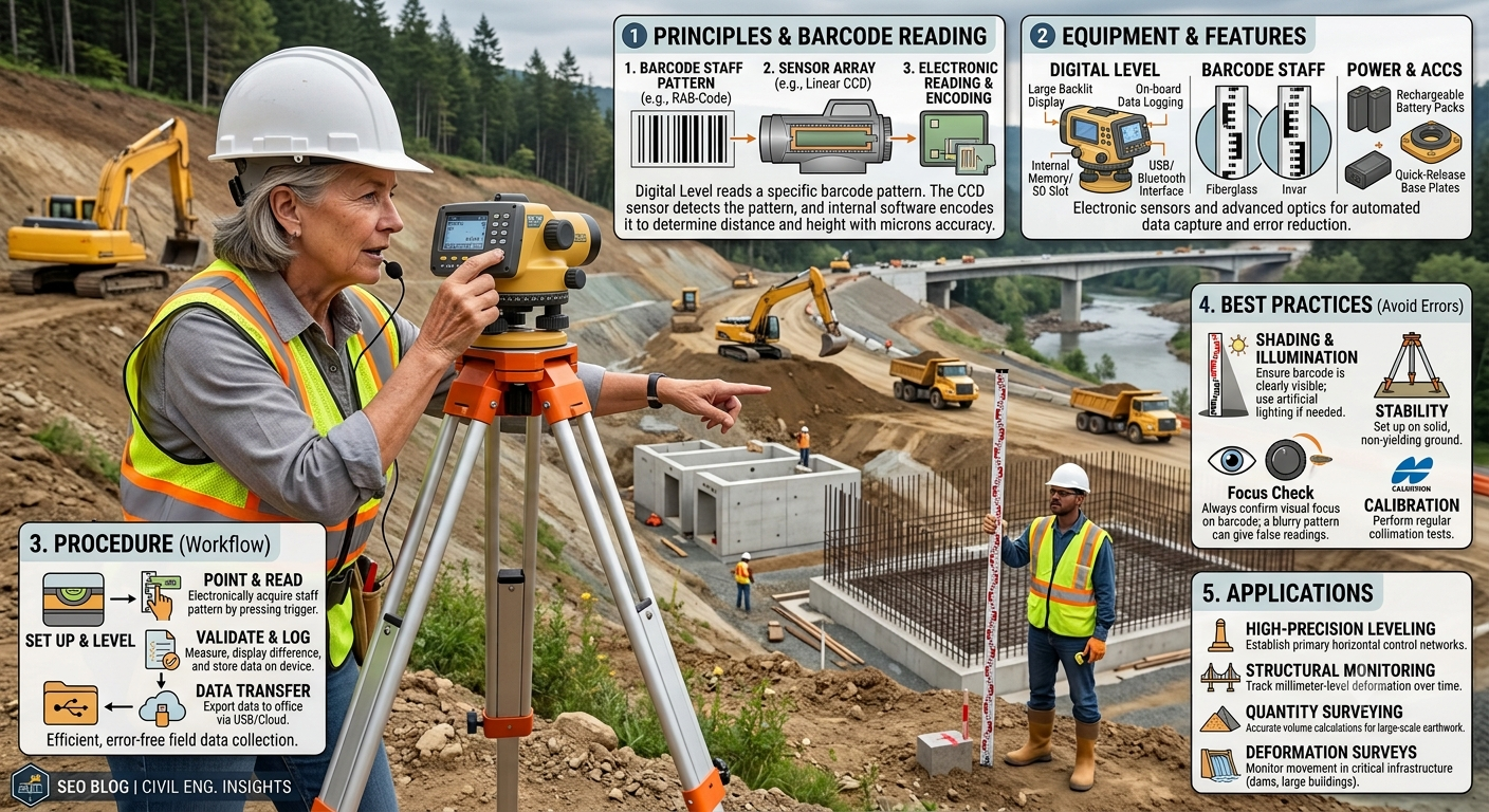
Surveying has evolved significantly with advances in digital technology. Traditional leveling methods that relied heavily on manual reading and calculations are increasingly being replaced by faster, more accurate digital instruments. Among these innovations, the Digital Level Survey has become one of the most reliable techniques for determining elevations in civil engineering, road construction, railway projects, bridge construction, and land development.
A digital level combines precision optics with electronic image processing to automatically read a specially coded staff and calculate height differences. This automation minimizes human error, speeds up fieldwork, and improves data accuracy. As a result, digital leveling is now widely adopted by engineering consultants, contractors, government agencies, and survey professionals for projects where accurate elevation measurements are critical.
Whether you are a civil engineering student learning modern surveying techniques or a site engineer responsible for construction control, understanding the principles and procedures of a Digital Level Survey is essential for producing reliable survey data and ensuring successful project execution.
What is a Digital Level Survey?
A Digital Level Survey is a modern surveying technique used to accurately determine differences in elevation between two or more points using an electronic leveling instrument and a coded leveling staff.
Unlike conventional dumpy or automatic levels, a digital level automatically captures the staff reading through an internal camera and image-processing system. The measured values are displayed instantly on the instrument screen and stored electronically, eliminating manual reading and reducing calculation errors.
This method is widely used where high precision is required, including:
- Highway construction
- Railway engineering
- Bridge projects
- Building construction
- Canal alignment
- Land development
- Dam construction
- Industrial infrastructure
Because the measurements are recorded digitally, survey results are more consistent, traceable, and easier to transfer into engineering software.
Why Digital Level Surveys Are Important
Accurate elevation data is fundamental to every construction project. Even minor errors in leveling can lead to drainage problems, uneven pavements, structural settlement, or increased construction costs.
A digital level survey offers several advantages over traditional methods by improving both accuracy and productivity.
Key Benefits
- Faster field measurements
- Reduced human error
- Automatic data recording
- High measurement precision
- Simplified data management
- Improved project efficiency
- Better quality control
These benefits make digital leveling an essential surveying technique for modern infrastructure projects.
Principle of a Digital Level Survey
The working principle of a digital level survey is based on electronic image recognition.
Instead of relying on the surveyor to manually read graduation marks on a leveling staff, the digital level uses an internal optical system and digital camera to scan a specially designed barcode staff.
The instrument processes the barcode image electronically and calculates:
- Staff reading
- Horizontal distance
- Height difference
- Reduced level (depending on the model)
The measured data is displayed immediately on the screen and stored in the instrument’s memory for later download.
Engineering Principle
The instrument establishes a horizontal line of sight after proper leveling. By comparing readings taken on the backsight and foresight positions, the elevation difference between survey points is determined accurately.
Simplified Measurement Formula
Height Difference = Backsight − Foresight
This principle is identical to conventional leveling, but the reading process is automated.
Main Components of a Digital Level
Understanding the parts of a digital level helps surveyors operate the equipment efficiently and maintain measurement accuracy.
1. Digital Level Instrument
The instrument contains:
- Telescope
- Internal digital camera
- Image processor
- Electronic compensator
- LCD display
- Keyboard
- Memory storage
- Communication ports
It automatically detects and interprets the barcode pattern on the staff.
2. Barcode Staff
A digital level uses a specially manufactured barcode staff instead of a conventional graduated leveling staff.
The barcode pattern allows the instrument to:
- Identify the staff automatically
- Read elevations precisely
- Calculate distances electronically
Using the correct staff is essential because ordinary leveling staffs are incompatible with digital levels.
3. Tripod
The tripod provides a stable platform for the instrument.
A rigid tripod minimizes vibrations caused by:
- Wind
- Passing vehicles
- Uneven ground
- Operator movement
Stable instrument setup is critical for achieving precise measurements.
4. Internal Memory and Software
Modern digital levels can store hundreds or even thousands of observations.
Stored data typically includes:
- Point numbers
- Staff readings
- Elevation differences
- Distances
- Time and date
- Survey project information
This digital storage reduces paperwork and simplifies office processing.
5. Battery System
Rechargeable batteries provide power for field operations.
Survey teams should always carry spare batteries to avoid interruptions during large projects.
Step-by-Step Digital Level Survey Procedure
Proper field procedures ensure accurate and repeatable survey results.
Step 1: Site Preparation
Before beginning the survey:
- Inspect the survey area.
- Identify benchmark locations.
- Remove visual obstructions.
- Plan instrument setups.
- Check weather conditions.
Good planning improves efficiency and reduces unnecessary instrument movement.
Step 2: Instrument Setup
Place the tripod on firm ground and mount the digital level securely.
The setup process includes:
- Extending tripod legs evenly
- Centering the instrument
- Leveling using the foot screws
- Checking the electronic bubble
Once leveled, the instrument establishes a horizontal reference line.
Step 3: Staff Positioning
Position the barcode staff vertically on the benchmark or survey point.
The staff should:
- Stand perfectly vertical
- Rest on stable ground
- Face the instrument directly
- Remain motionless during observation
Many staffs include a circular bubble level to assist in maintaining verticality.
Step 4: Automatic Reading
Aim the telescope at the barcode staff and focus clearly.
When the measurement button is pressed, the instrument:
- Captures the barcode image.
- Processes the pattern electronically.
- Calculates the staff reading.
- Measures the horizontal distance.
- Displays the results instantly.
Unlike manual leveling, no visual interpretation by the surveyor is required.
Step 5: Data Storage
Each observation is automatically stored in the instrument memory.
Typical stored information includes:
- Point ID
- Reading
- Distance
- Date
- Time
- Survey file name
Digital storage reduces transcription errors and simplifies report preparation.
Step 6: Verification
Before leaving the site, engineers should verify:
- Instrument leveling
- Benchmark readings
- Closure error
- Stored observations
- Staff condition
A final verification helps detect mistakes before demobilization.
Topic-Related Diagrams
Diagram 1: Digital Level Survey Setup
                 Line of Sight
------------------------------------------------------

          Digital Level
               ▲
               │
          ┌──────────┐
          │ Instrument│
          └──────────┘
               │
            Tripod
               │
               │
============================================== Ground

                               │
                               │
                           Barcode Staff
                               │
                               │
                           Survey Point
Diagram 2: Basic Digital Leveling Process
Benchmark (RL Known)
        │
        ▼
Backsight Reading
        │
        ▼
Digital Level
        │
        ▼
Foresight Reading
        │
        ▼
New Reduced Level
Advantages of Digital Level Survey
Compared with conventional leveling methods, digital levels offer significant technical and operational advantages.
Higher Accuracy
Electronic image recognition eliminates many manual reading errors.
Faster Measurements
Automatic staff recognition significantly reduces observation time.
Reduced Human Error
The instrument performs calculations automatically, minimizing transcription and arithmetic mistakes.
Digital Data Recording
Survey observations are stored electronically, reducing paperwork and improving traceability.
Improved Productivity
Survey teams can complete more observations in less time, especially on large infrastructure projects.
Better Quality Control
Stored data can be reviewed, verified, and transferred directly to engineering software.
Applications of Digital Level Survey
Digital leveling is widely used across multiple civil engineering disciplines.
Highway Engineering
- Longitudinal profile surveys
- Cross-section surveys
- Pavement construction
- Drainage grading
Railway Engineering
- Track alignment
- Rail level monitoring
- Ballast maintenance
Building Construction
- Foundation leveling
- Floor elevation control
- Structural monitoring
Bridge Engineering
- Pier construction
- Deck elevation checks
- Settlement monitoring
Water Resources Projects
- Canal construction
- Reservoir development
- Dam monitoring
- Irrigation systems
Land Development
- Site grading
- Earthwork quantity calculations
- Residential and industrial development
Best Practices for Digital Level Surveys
To obtain reliable and repeatable results:
- Calibrate the instrument regularly.
- Use only compatible barcode staffs.
- Keep the instrument clean and dry.
- Avoid measurements during heavy rain or excessive heat shimmer.
- Balance backsight and foresight distances whenever practical.
- Verify benchmark elevations periodically.
- Download and back up survey data daily.
- Inspect the tripod and staff before each survey.
- Train operators in both field procedures and data management.
- Follow project specifications and quality assurance protocols.
Limitations of a Digital Level Survey
Although a Digital Level Survey offers exceptional accuracy and efficiency, it is not without limitations. Understanding these constraints helps surveyors choose the appropriate equipment and adopt suitable field practices.
1. Higher Initial Cost
Digital levels are significantly more expensive than traditional dumpy and automatic levels. In addition to the instrument itself, survey teams must purchase compatible barcode staffs, software, and accessories, making the initial investment relatively high.
2. Dependence on Power Supply
Unlike conventional optical levels, digital levels rely on rechargeable batteries. If battery power is exhausted during fieldwork, measurements cannot continue until a charged battery is installed.
3. Requirement for Barcode Staff
Digital levels can only read specially designed barcode staffs. Standard leveling staffs used with optical instruments cannot be used, which limits equipment compatibility.
4. Sensitive Electronic Components
Dust, moisture, excessive vibration, and accidental impacts may affect electronic components. Proper handling, transportation, and storage are essential to maintain accuracy and extend the instrument’s service life.
5. Reduced Performance in Poor Visibility
Heavy rain, dense fog, strong heat shimmer, or low-light conditions may reduce the instrument’s ability to detect the barcode pattern accurately.
6. Training Requirements
Although digital levels automate many operations, surveyors still require proper training in instrument setup, observation techniques, data management, and error checking to obtain reliable results.
Common Errors in Digital Level Survey and How to Avoid Them
Even with advanced automation, errors can occur if proper surveying practices are not followed.
Instrument Not Properly Leveled
An incorrectly leveled instrument introduces systematic errors into elevation measurements.
Solution:
- Verify the electronic bubble before every observation.
- Re-level the instrument whenever the tripod is disturbed.
Barcode Staff Not Vertical
A leaning staff produces inaccurate readings and incorrect height differences.
Solution:
- Use the staff’s circular bubble.
- Hold the staff firmly and vertically during each observation.
Dirty Instrument Lens
Dust or moisture on the objective lens can interfere with barcode recognition.
Solution:
- Clean the lens with an approved microfiber cloth before beginning work.
- Store the instrument in its protective case when not in use.
Unequal Sight Distances
Large differences between backsight and foresight distances may increase the effect of systematic errors.
Solution:
- Keep backsight and foresight distances approximately equal whenever practical.
Low Battery Voltage
Insufficient battery power may interrupt data collection or prevent accurate measurements.
Solution:
- Charge batteries fully before fieldwork.
- Carry spare batteries for long survey sessions.
Failure to Verify Benchmark
Starting from an incorrect benchmark elevation affects all subsequent calculations.
Solution:
- Confirm benchmark values before beginning the survey.
- Perform closure checks whenever possible.
Digital Level vs Automatic Level vs Dumpy Level
Choosing the appropriate leveling instrument depends on project requirements, budget, and required accuracy.
| Feature | Digital Level | Automatic Level | Dumpy Level |
|---|---|---|---|
| Reading Method | Automatic electronic reading | Manual reading | Manual reading |
| Accuracy | Very High | High | Moderate |
| Speed | Very Fast | Moderate | Slow |
| Human Error | Minimal | Moderate | Higher |
| Data Storage | Electronic memory | Manual field book | Manual field book |
| Calculations | Automatic | Manual | Manual |
| Cost | Highest | Moderate | Lowest |
| Suitable for Large Projects | Excellent | Good | Limited |
Engineering Perspective
- Digital levels are ideal for highways, railways, bridges, dams, and precision engineering projects.
- Automatic levels are suitable for routine construction surveys where moderate accuracy is sufficient.
- Dumpy levels remain useful for educational purposes and small-scale projects but are gradually being replaced by more advanced instruments.
Practical Applications in Modern Civil Engineering
The use of digital levels extends across a wide range of infrastructure projects.
Highway Construction
Engineers use digital levels to establish formation levels, monitor pavement elevations, and verify longitudinal and cross-sectional profiles.
Railway Projects
Digital leveling ensures accurate rail alignment, ballast grading, and track elevation control, contributing to safe and efficient railway operations.
Bridge Construction
Surveyors monitor pier elevations, deck levels, bearing installations, and settlement throughout construction.
Building Projects
Digital levels help control excavation depths, foundation elevations, floor levels, and structural alignment in multi-storey buildings.
Dam and Reservoir Construction
Accurate elevation data supports embankment construction, spillway alignment, and deformation monitoring.
Industrial Facilities
Factories, warehouses, airports, and logistics hubs require precise leveling to ensure proper drainage and structural performance.
Engineering Best Practices
Experienced surveyors follow standardized procedures to maximize accuracy and reliability.
- Inspect the instrument before every survey.
- Perform regular calibration according to the manufacturer’s recommendations.
- Protect the instrument from excessive dust, rain, and direct sunlight.
- Use stable tripod setups on firm ground.
- Keep observation distances balanced.
- Record benchmark information carefully.
- Download and back up digital data at the end of each working day.
- Verify measurements by conducting independent checks.
- Maintain detailed survey documentation for future reference.
- Follow project specifications and quality assurance procedures consistently.
Practical Recommendations
Civil Engineers
- Verify benchmark elevations before beginning any leveling work.
- Review survey data regularly to identify inconsistencies.
- Integrate digital survey results with CAD, BIM, or GIS platforms for improved project coordination.
- Include periodic instrument calibration in project quality plans.
Contractors
- Train survey crews on proper digital leveling techniques.
- Maintain spare batteries and backup storage devices on site.
- Protect instruments during transportation and storage.
- Schedule routine equipment inspections to prevent unexpected failures.
Engineering Students
- Develop a strong understanding of conventional leveling principles before using digital instruments.
- Practice field observations under different site conditions.
- Learn how to download, process, and interpret digital survey data.
- Compare digital and traditional leveling methods to appreciate their respective advantages.
General Discussion of IRC, AASHTO, and ICE Practices
International engineering organizations emphasize the importance of accurate surveying for successful infrastructure projects.
In general, guidance associated with IRC (Indian Roads Congress), AASHTO (American Association of State Highway and Transportation Officials), and the Institution of Civil Engineers (ICE) highlights the following principles:
- Establish reliable control points before construction.
- Verify benchmark elevations using approved surveying methods.
- Maintain instrument calibration and periodic performance checks.
- Follow standardized field procedures for leveling operations.
- Document survey observations systematically for quality assurance.
- Incorporate accurate elevation data into pavement, drainage, bridge, and earthwork design.
- Perform independent verification surveys before critical construction activities.
Adhering to these principles improves construction accuracy, enhances safety, and reduces costly rework.
Frequently Asked Questions (FAQs)
1. What is a Digital Level Survey?
A Digital Level Survey is a modern surveying method that uses an electronic leveling instrument and a barcode staff to measure differences in elevation accurately and automatically.
2. How does a digital level differ from an automatic level?
A digital level reads a barcode staff electronically and stores measurements digitally, whereas an automatic level requires manual staff readings and handwritten calculations.
3. Where is a Digital Level Survey commonly used?
It is widely used in highway construction, railway engineering, bridge projects, building construction, land development, dam construction, and industrial infrastructure.
4. Why is a barcode staff necessary?
The instrument uses image recognition technology to interpret the barcode pattern. Conventional graduated staffs cannot provide the required electronic readings.
5. What factors affect the accuracy of digital leveling?
Instrument calibration, proper leveling, staff verticality, balanced sight distances, stable tripod setup, and favorable weather conditions all influence measurement accuracy.
6. Can digital levels work at night?
Yes, provided there is sufficient illumination for the instrument to recognize the barcode staff clearly. However, additional lighting may be necessary depending on site conditions.
7. What are the primary advantages of digital leveling?
Digital leveling offers higher accuracy, faster observations, automatic calculations, electronic data storage, reduced human error, and improved productivity.
8. How often should a digital level be calibrated?
Calibration frequency depends on manufacturer recommendations, project specifications, and usage. Instruments should also be checked after transportation, accidental impacts, or prolonged storage.
9. Is digital leveling suitable for small construction projects?
Yes. Although digital levels are commonly associated with large infrastructure works, they can also improve efficiency and accuracy on smaller projects where precise elevation control is required.
10. Can survey data from a digital level be transferred to engineering software?
Yes. Most modern digital levels support data transfer to surveying, CAD, GIS, and BIM software, making processing and documentation more efficient.
Conclusion
A Digital Level Survey has transformed modern surveying by combining precision optics, electronic image recognition, and automated data processing into a single efficient system. Compared with traditional leveling methods, it provides faster observations, higher accuracy, reliable digital records, and significantly reduces the risk of manual reading and calculation errors. These advantages make it an indispensable tool for highway projects, railways, bridges, buildings, dams, and large-scale infrastructure developments where precise elevation control is essential. However, achieving dependable results requires more than advanced equipment. Proper instrument calibration, correct field procedures, regular maintenance, and adherence to recognized engineering standards are equally important. Civil engineers, contractors, and students who understand the principles, applications, limitations, and best practices of a Digital Level Survey will be better equipped to deliver accurate survey data, improve construction quality, minimize costly rework, and contribute to safe, durable, and sustainable engineering projects.

Kamran Malik is a passionate civil engineering writer and researcher who specializes in construction, transportation, structural engineering, and infrastructure topics. Through his articles on CivilEngineerings.com, he simplifies complex engineering concepts and shares practical insights, industry trends, and educational resources for students, professionals, and engineering enthusiasts.