
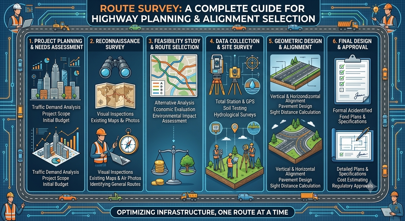
Highway construction begins long before excavation, grading, or paving work starts. One of the most critical activities during the planning phase is the Route Survey, which helps engineers identify the safest, most economical, and technically feasible alignment for a proposed road or highway. A well-executed survey minimizes construction costs, reduces environmental impacts, and improves the long-term performance of transportation infrastructure.
A Route Survey is more than simply measuring distances on the ground. It combines surveying techniques, geotechnical observations, traffic studies, topographic analysis, and engineering judgment to evaluate alternative routes before selecting the final alignment. Accurate survey data forms the foundation of highway design, ensuring that roads meet safety standards, accommodate future traffic growth, and integrate effectively with the surrounding environment.
Whether you are a civil engineer, transportation professional, contractor, or engineering student, understanding the route survey process is essential for successful highway project planning. This guide explains each stage of a route survey, its objectives, practical applications, and the engineering principles that influence route selection.
What Is a Route Survey?
A Route Survey is a systematic engineering investigation conducted to identify and evaluate the most suitable alignment for a transportation corridor such as a highway, railway, pipeline, canal, or transmission line. The survey collects accurate field data related to terrain, topography, soil conditions, drainage, existing infrastructure, and environmental constraints.
In highway engineering, the primary purpose of a route survey is to determine an alignment that satisfies technical, economic, environmental, and safety requirements while minimizing construction and maintenance costs.
Unlike ordinary land surveys, a route survey covers a continuous corridor rather than a single parcel of land. Surveyors and engineers assess multiple alignment alternatives before recommending the optimal route for detailed design and construction.
Main Objectives of a Route Survey
A properly executed route survey aims to:
- Identify the most practical highway alignment.
- Minimize earthwork and construction costs.
- Reduce environmental and social impacts.
- Ensure adequate sight distance and safe geometric design.
- Avoid unstable soil and geological hazards.
- Optimize drainage and water crossings.
- Support efficient land acquisition planning.
- Provide accurate data for detailed engineering design.
These objectives help ensure that the selected alignment performs efficiently throughout its design life.
Why Is a Route Survey Important?
The quality of a highway project depends heavily on the accuracy of its route survey. Incorrect alignment selection can increase construction costs, create maintenance challenges, and compromise road safety.
A comprehensive survey allows engineers to evaluate several route alternatives before committing to the final design. This process reduces uncertainties and improves project outcomes.
Key Benefits
- Improves alignment accuracy.
- Reduces unnecessary excavation and embankment work.
- Minimizes bridge and culvert construction where practical.
- Avoids environmentally sensitive areas.
- Enhances traffic safety through better geometric design.
- Supports accurate cost estimation.
- Simplifies future maintenance activities.
- Reduces construction delays caused by unforeseen site conditions.
Practical Example
Imagine two possible alignments connecting neighboring cities. The first passes through steep hills requiring extensive rock excavation and multiple retaining walls. The second follows gently rolling terrain with stable soil conditions and fewer stream crossings. Although the second route is slightly longer, it may prove significantly more economical over the project’s lifecycle due to lower construction and maintenance costs.
Route Survey Process
A highway route survey generally progresses through four major stages. Each stage builds upon the previous one, gradually increasing the level of detail until engineers finalize the highway alignment.
Stage 1: Map Study (Desk Study)
The map study is the first stage of route planning. Before visiting the project site, engineers analyze available maps, satellite imagery, aerial photographs, and geographic information systems (GIS) to identify potential corridors.
This preliminary evaluation helps eliminate unsuitable routes and focuses field investigations on the most promising alternatives.
Information Reviewed
Engineers examine:
- Topographic maps
- Digital elevation models (DEMs)
- Satellite imagery
- Existing road networks
- Rivers and drainage patterns
- Railways
- Urban and rural settlements
- Forests and protected areas
- Utility corridors
- Administrative boundaries
Engineering Considerations
During the desk study, engineers attempt to:
- Minimize sharp curves.
- Reduce steep gradients.
- Avoid flood-prone regions.
- Limit river crossings.
- Reduce bridge construction.
- Minimize impacts on populated areas.
- Preserve environmentally sensitive locations.
Benefits of Map Study
- Saves time during field investigations.
- Reduces survey costs.
- Improves planning efficiency.
- Identifies potential engineering challenges early.
- Supports informed decision-making.
Stage 2: Reconnaissance Survey
After completing the desk study, engineers visit the field to verify the information collected from maps and satellite images.
The reconnaissance survey provides a general understanding of actual ground conditions and identifies factors that cannot be accurately observed through remote data alone.
Objectives
The reconnaissance survey aims to:
- Confirm map information.
- Observe terrain characteristics.
- Assess accessibility.
- Identify natural obstacles.
- Locate possible river crossings.
- Evaluate existing infrastructure.
- Observe geological conditions.
Field Activities
Survey teams typically perform:
- Visual inspections
- GPS observations
- Preliminary measurements
- Photography
- Drone reconnaissance (where available)
- Discussions with local communities
Factors Observed
Engineers assess:
- Hills and valleys
- Rock outcrops
- Marshy areas
- Existing utilities
- Drainage conditions
- Vegetation
- Land use
- Soil exposure
- Construction access
Practical Example
A satellite image may indicate a flat area suitable for highway construction. However, a reconnaissance survey may reveal seasonal flooding or weak soils that make the location unsuitable. Field verification prevents costly design revisions later in the project.
Stage 3: Preliminary Survey
The preliminary survey is the first stage involving detailed engineering measurements. At this point, a limited number of alternative alignments are investigated using accurate surveying techniques.
The objective is to collect sufficient data for comparing alternative routes and selecting the most suitable alignment.
Survey Activities
Topographic Survey
Measures:
- Ground elevations
- Slopes
- Contours
- Natural drainage
- Existing structures
Longitudinal Survey
Develops the longitudinal profile along each proposed alignment.
This profile helps engineers design vertical curves and determine earthwork quantities.
Cross-Section Survey
Cross-sections are taken at regular intervals to determine:
- Existing ground shape
- Cut and fill requirements
- Side slope design
- Drainage needs
Control Survey
Establishes permanent horizontal and vertical control points used during detailed design and construction.
Data Collected
The preliminary survey typically records:
- Coordinates
- Elevations
- Distances
- Existing utilities
- Water bodies
- Buildings
- Trees
- Geological features
Engineering Analysis
Using the collected information, engineers compare each alignment based on:
- Earthwork quantities
- Construction cost
- Pavement length
- Bridge requirements
- Drainage structures
- Environmental impacts
- Safety considerations
- Future expansion opportunities
The alignment offering the best balance between technical feasibility, cost, safety, and sustainability is recommended for the final location survey.
Route Survey Workflow Diagram
Project Requirement
        │
        ▼
Map Study
        │
        ▼
Reconnaissance Survey
        │
        ▼
Preliminary Survey
        │
        ▼
Final Location Survey
        │
        ▼
Detailed Highway Design
This step-by-step approach ensures that alignment decisions are based on reliable engineering data rather than assumptions.
Stage 4: Final Location Survey
After evaluating alternative alignments during the preliminary survey, engineers select the preferred route and carry out the Final Location Survey. This stage provides the precise measurements required for detailed highway design and construction.
The final location survey establishes the exact centerline of the proposed highway and supplies all geometric, topographic, and control data needed to prepare construction drawings.
Objectives of the Final Location Survey
The primary objectives include:
- Fixing the final highway alignment.
- Establishing permanent survey control points.
- Determining exact coordinates and elevations.
- Preparing longitudinal profiles and cross-sections.
- Calculating earthwork quantities.
- Locating drainage structures.
- Supporting land acquisition and utility relocation.
Major Activities
Survey teams typically perform the following tasks:
Centerline Setting Out
The highway centerline is marked on the ground using permanent reference points to guide future construction activities.
Detailed Leveling
Accurate elevations are recorded to design gradients, vertical curves, drainage systems, and pavement levels.
Cross-Section Measurements
Cross-sections are taken at regular intervals and at locations where terrain changes significantly. These measurements help estimate excavation and embankment requirements.
Location of Existing Features
Engineers identify and map:
- Buildings
- Utility lines
- Bridges
- Culverts
- Rivers
- Trees
- Property boundaries
- Existing roads
Deliverables
A completed final location survey generally produces:
- Alignment plans
- Longitudinal profiles
- Cross-section drawings
- Survey control maps
- Earthwork calculations
- Coordinate data
- Construction reference benchmarks
The accuracy of this stage directly influences construction quality, project cost, and future maintenance.
Survey Equipment Used in Route Surveys
Modern route surveys combine traditional surveying methods with advanced digital technologies. Selecting the right equipment improves efficiency, precision, and data reliability.
Total Station
A Total Station combines an electronic theodolite with an electronic distance meter (EDM). It measures angles, distances, and coordinates with high accuracy.
Applications:
- Alignment surveys
- Cross-section surveys
- Stakeout work
- Construction layout
Global Navigation Satellite System (GNSS/GPS)
High-precision GPS receivers determine accurate geographic coordinates using satellite signals.
Applications:
- Route mapping
- Control surveys
- Boundary surveys
- Large-scale corridor surveys
Automatic Level
An automatic level is used to measure differences in elevation between points.
Applications:
- Longitudinal profiles
- Cross-sections
- Drainage design
- Pavement level checks
Unmanned Aerial Vehicles (Drones)
Drones equipped with high-resolution cameras rapidly capture aerial imagery and terrain data.
Advantages:
- Faster data collection
- Improved safety
- Reduced field time
- High-resolution mapping
- Better access to difficult terrain
LiDAR Technology
Light Detection and Ranging (LiDAR) creates highly accurate three-dimensional terrain models using laser scanning.
Benefits:
- Dense elevation data
- Accurate surface modeling
- Improved corridor mapping
- Faster processing of large project areas
Engineering Principles Behind Route Survey
Every route survey follows established engineering principles that balance technical performance, safety, environmental responsibility, and cost.
Safety
The selected alignment should provide:
- Adequate sight distance
- Safe curves
- Suitable gradients
- Stable slopes
- Clear roadside zones
Economy
Engineers aim to reduce:
- Earthwork volumes
- Bridge lengths
- Land acquisition costs
- Construction time
- Maintenance expenses
Environmental Sustainability
Responsible route selection seeks to:
- Avoid wetlands
- Protect forests
- Preserve wildlife habitats
- Minimize soil erosion
- Reduce carbon emissions during construction
Constructability
The alignment should allow efficient construction using available equipment and materials while minimizing logistical challenges.
Future Expansion
Engineers consider future traffic growth by providing space for additional lanes, service roads, utilities, and transportation improvements where feasible.
Practical Applications of Route Surveys
Route surveys are not limited to highways. They play an essential role in many infrastructure projects.
Highways and Expressways
Selecting safe and economical road alignments.
Railways
Designing railway corridors with appropriate gradients and curves.
Pipelines
Planning oil, gas, and water transmission routes.
Transmission Lines
Identifying suitable corridors for electrical power distribution.
Irrigation Canals
Determining efficient canal alignments while maintaining gravity flow.
Urban Transportation
Supporting the development of ring roads, bypasses, metro corridors, and bus rapid transit systems.
Real-World Example
Suppose a transportation authority plans a new 80-kilometer highway connecting two industrial cities.
During the desk study, engineers identify three possible corridors. Reconnaissance surveys reveal that one route crosses unstable hillsides, increasing construction complexity and maintenance risks. Another alignment passes through densely populated areas, leading to significant land acquisition costs and social impacts. The third corridor follows gently rolling terrain with stable soil conditions, fewer river crossings, and limited environmental constraints.
After completing preliminary surveys and comparing construction costs, earthwork quantities, drainage requirements, and long-term maintenance needs, the third alignment is selected. Although slightly longer than one alternative, it offers lower lifecycle costs, improved safety, and better opportunities for future expansion.
This example illustrates how a comprehensive route survey supports informed engineering decisions rather than relying solely on the shortest distance.
Common Challenges During Route Surveys
Survey teams frequently encounter obstacles that require technical expertise and careful planning.
Difficult Terrain
Mountainous regions, dense forests, and steep slopes can restrict access and increase survey time.
Solution: Use drones, GNSS equipment, and LiDAR to improve efficiency.
Adverse Weather
Heavy rainfall, flooding, and extreme temperatures may delay fieldwork.
Solution: Schedule surveys during favorable seasons and maintain flexible project timelines.
Limited Site Access
Private properties and environmentally protected areas may restrict survey operations.
Solution: Obtain necessary permissions and coordinate with relevant authorities before mobilization.
Inaccurate Existing Data
Outdated maps and incomplete records can create design errors.
Solution: Verify all information through field investigations and modern surveying techniques.
Best Practices for Route Surveys
Following recognized best practices improves survey accuracy and project success.
- Begin with a detailed desk study before field investigations.
- Verify satellite and map information through reconnaissance surveys.
- Use calibrated and well-maintained survey equipment.
- Establish permanent control points before detailed measurements.
- Record field observations systematically.
- Validate collected data through quality assurance procedures.
- Integrate GIS, GPS, drones, and LiDAR where appropriate.
- Coordinate closely with geotechnical, environmental, and design teams.
- Consider future development plans during route selection.
- Maintain comprehensive documentation throughout the survey process.
Practical Recommendations
Civil Engineers
- Compare multiple alignment alternatives before selecting the preferred route.
- Review geotechnical reports alongside survey data.
- Prioritize safety, constructability, and lifecycle costs rather than focusing only on initial construction expenses.
Contractors
- Confirm survey benchmarks before construction begins.
- Protect permanent survey markers throughout the project.
- Report any discrepancies between design drawings and field conditions immediately.
Engineering Students
- Develop proficiency with Total Stations, GNSS equipment, and leveling instruments.
- Learn to interpret contour maps, longitudinal profiles, and cross-sections.
- Participate in field surveys to understand real-world surveying procedures.
- Study both traditional surveying techniques and modern digital technologies.
General Discussion of IRC, AASHTO, and ICE Practices
Professional organizations such as the Indian Roads Congress (IRC), the American Association of State Highway and Transportation Officials (AASHTO), and the Institution of Civil Engineers (ICE) emphasize several common principles for route surveys:
- Base alignment decisions on accurate topographic and geotechnical data.
- Consider traffic demand, safety, and future expansion during route selection.
- Integrate environmental and social factors into planning.
- Follow standardized surveying procedures and quality control practices.
- Use reliable control networks and verified measurements throughout the project.
- Coordinate survey activities with highway design, drainage, and structural engineering teams.
- Maintain thorough documentation to support design, construction, and future maintenance.
Although detailed specifications vary by jurisdiction, these principles reflect internationally recognized engineering practices for highway planning.
Frequently Asked Questions (FAQs)
1. What is a route survey in highway engineering?
A route survey is the systematic process of collecting topographic, geotechnical, environmental, and alignment data to identify the most suitable route for a proposed highway.
2. Why is a route survey necessary?
It helps engineers select a safe, economical, and environmentally responsible alignment while reducing construction risks and long-term maintenance costs.
3. What are the main stages of a route survey?
The typical stages are map study, reconnaissance survey, preliminary survey, and final location survey.
4. Which instruments are commonly used in route surveys?
Common equipment includes Total Stations, GNSS/GPS receivers, automatic levels, drones, LiDAR systems, and electronic distance measurement (EDM) devices.
5. How does a route survey influence project costs?
An accurate survey minimizes unnecessary earthwork, reduces bridge and culvert requirements where feasible, avoids unstable ground, and improves overall construction efficiency.
6. What factors influence route selection?
Engineers evaluate terrain, geology, drainage, environmental impacts, land use, traffic demand, construction costs, and future expansion requirements.
7. What is the difference between a reconnaissance survey and a preliminary survey?
A reconnaissance survey provides a general field assessment, while a preliminary survey collects detailed engineering measurements for comparing alternative alignments.
8. How do modern technologies improve route surveys?
Technologies such as GNSS, drones, GIS, and LiDAR increase survey accuracy, reduce field time, improve safety, and generate highly detailed terrain models.
9. What role does geotechnical information play in a route survey?
Geotechnical data identifies soil strength, groundwater conditions, and geological hazards, allowing engineers to select stable and cost-effective alignments.
10. Can a route survey reduce environmental impacts?
Yes. By evaluating multiple alternatives, engineers can avoid environmentally sensitive areas, reduce habitat disruption, and minimize erosion and drainage problems.
Conclusion
A Route Survey is one of the most important stages in highway planning because it establishes the technical foundation for every design and construction decision that follows. From the initial desk study and reconnaissance survey to the preliminary investigation and final location survey, each step provides essential information about terrain, soil conditions, drainage, existing infrastructure, and environmental constraints. Accurate survey data enables engineers to choose alignments that improve safety, reduce construction costs, simplify maintenance, and support sustainable transportation development. Modern technologies such as GNSS, drones, LiDAR, and GIS have further enhanced the speed and precision of route surveys, allowing infrastructure projects to be planned with greater confidence. By following recognized engineering principles and the general guidance promoted by organizations such as IRC, AASHTO, and ICE, engineers, contractors, and students can ensure that every Route Survey contributes to reliable, durable, and economically efficient highway infrastructure.

Kamran Malik is a passionate civil engineering writer and researcher who specializes in construction, transportation, structural engineering, and infrastructure topics. Through his articles on CivilEngineerings.com, he simplifies complex engineering concepts and shares practical insights, industry trends, and educational resources for students, professionals, and engineering enthusiasts.