
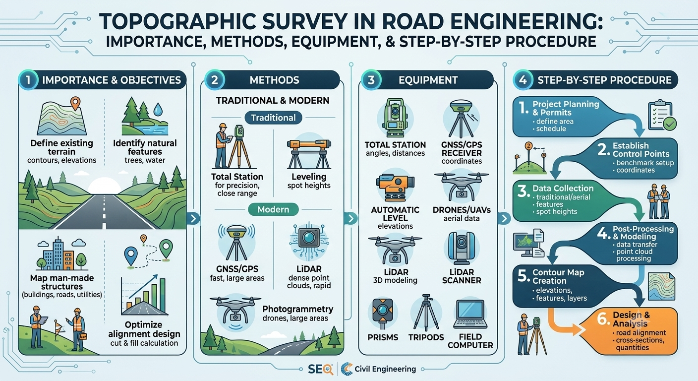
Topographic surveys are the foundation of nearly every successful civil engineering and infrastructure project. Before a highway, bridge, railway, building, or drainage system is designed, engineers need an accurate representation of the land’s physical features. A Topographic Survey provides this essential information by measuring natural features along with changes in ground elevation.
Without reliable topographic data, designers may overlook critical site conditions, resulting in costly redesigns, construction delays, drainage problems, or safety issues. For this reason, topographic surveying is considered one of the most important preliminary investigations in engineering projects.
Modern surveying combines traditional field techniques with advanced technologies such as Global Navigation Satellite Systems (GNSS), Total Stations, drones (UAVs), LiDAR, and Geographic Information Systems (GIS). These tools enable surveyors to produce highly accurate maps that support efficient planning, design, and construction.
Whether you are a civil engineering student, professional surveyor, contractor, or project manager, understanding the principles and applications of a Topographic Survey is essential for delivering safe, economical, and sustainable infrastructure.
What Is a Topographic Survey?
A Topographic Survey is a detailed measurement and mapping process that identifies the horizontal positions, elevations, and physical characteristics of a piece of land. It records both natural and artificial features, allowing engineers to understand the site’s shape and terrain before design or construction begins.
Unlike boundary surveys that define property limits, a topographic survey focuses on the land’s physical characteristics and elevation changes.
Typical features captured include:
Natural Features
- Hills
- Valleys
- Rivers
- Streams
- Lakes
- Trees
- Rock outcrops
- Slopes
Features
- Roads
- Buildings
- Bridges
- Utility poles
- Pipelines
- Drainage structures
- Fences
- Retaining walls
The collected information is presented using contour lines, spot levels, symbols, and coordinate systems to produce an accurate topographic map.
Why Is a Topographic Survey Important?
Every engineering project begins with understanding existing site conditions. A topographic survey provides the information required to make informed design decisions while reducing construction risks.
Its importance extends across planning, design, construction, and maintenance phases.
Key Benefits
- Provides accurate ground elevations.
- Helps determine suitable project layouts.
- Supports efficient drainage design.
- Reduces earthwork costs.
- Improves construction planning.
- Identifies potential site constraints.
- Enhances project safety.
- Minimizes design errors.
- Assists in environmental planning.
Without accurate terrain information, engineers may underestimate excavation quantities, overlook drainage paths, or design structures that require expensive modifications during construction.
Engineering Principles of Topographic Surveying
Topographic surveying is based on several fundamental engineering principles that ensure reliable and repeatable results.
Horizontal Positioning
Every surveyed point must have an accurate horizontal location based on a known coordinate system.
Vertical Positioning
The elevation of each point is measured relative to an established benchmark or reference datum.
Accuracy
Survey precision depends on project requirements. Highway alignments, bridge foundations, and large infrastructure projects typically require higher accuracy than preliminary land assessments.
Redundancy
Surveyors often collect overlapping measurements to verify field observations and reduce the likelihood of errors.
Data Integrity
Field observations should be properly recorded, checked, and validated before they are used for engineering design.
These principles ensure that the resulting topographic map accurately reflects the site’s physical conditions.
Equipment Used in a Topographic Survey
Advancements in surveying technology have significantly improved efficiency and accuracy. Modern projects often combine multiple instruments depending on the project size, terrain, and required precision.
Total Station
A Total Station measures:
- Horizontal angles
- Vertical angles
- Distances
- Coordinates
- Elevations
It combines an electronic theodolite with an electronic distance measurement (EDM) device, making it one of the most widely used surveying instruments.
GNSS/GPS Receiver
Global Navigation Satellite System (GNSS) receivers determine precise coordinates using satellite signals.
These receivers are especially useful for:
- Large infrastructure projects
- Highway corridors
- Pipeline alignments
- Land development
Automatic Level
An automatic level is primarily used to establish accurate elevations and determine differences in height between points.
Drone (UAV)
Unmanned Aerial Vehicles equipped with high-resolution cameras or LiDAR sensors can quickly collect terrain data over large or inaccessible areas.
LiDAR Scanner
LiDAR technology uses laser pulses to create dense three-dimensional point clouds, enabling highly detailed terrain models even in complex environments.
Types of Topographic Surveys
Different projects require different survey approaches. The choice depends on project objectives, site conditions, required accuracy, and available equipment.
Ground Survey
This traditional method uses Total Stations, levels, and GNSS equipment to collect detailed field measurements.
It offers excellent accuracy and is commonly used for buildings, roads, and bridge projects.
Aerial Survey
Aircraft or drones capture aerial imagery to generate digital terrain models and contour maps.
This method is ideal for:
- Highways
- Railways
- Large industrial sites
- Mining projects
LiDAR Survey
LiDAR surveys provide extremely accurate elevation data and are particularly effective in forested areas where conventional aerial photography may be limited.
Hydrographic Topographic Survey
Projects involving rivers, lakes, reservoirs, or coastal developments often combine topographic and hydrographic surveys to measure both land and underwater features.
Step-by-Step Topographic Survey Process
A systematic surveying process ensures complete and accurate data collection.
Step 1: Project Planning and Reconnaissance
Every survey begins with a site visit.
Surveyors inspect the project area to understand terrain conditions, identify obstacles, determine access routes, and select suitable control point locations.
During reconnaissance, the team also reviews:
- Existing maps
- Satellite imagery
- Design requirements
- Utility information
- Environmental conditions
Proper planning reduces field delays and improves overall survey efficiency.
Step 2: Establishing Survey Control
Survey control provides the reference framework for all subsequent measurements.
Control points are established using:
- Permanent benchmarks
- GNSS observations
- Traverses
- Existing survey monuments
These control stations ensure that all measured features are accurately referenced within the project coordinate system.
Reliable survey control is essential for maintaining consistency throughout design and construction.
Step 3: Field Data Collection
Once control points have been established, surveyors begin measuring terrain features and elevations.
Typical observations include:
- Spot levels
- Building corners
- Road edges
- Utility structures
- Watercourses
- Trees
- Retaining walls
- Drainage channels
- Existing pavement
- Property features
Field crews carefully verify measurements before leaving the site to avoid costly repeat visits.
Step 4: Recording Elevations and Features
Elevation data is one of the defining components of a topographic survey.
Surveyors collect sufficient points to accurately represent the terrain, particularly in areas where ground levels change rapidly.
Additional measurements are taken around:
- Embankments
- Slopes
- Channels
- Road intersections
- Building platforms
- Drainage systems
The density of survey points depends on terrain complexity and project requirements. Uneven ground generally requires a greater number of observations to produce an accurate topographic model.
Practical Engineering Example
Consider the planning of a new four-lane highway through rolling terrain. Before the alignment is finalized, a topographic survey identifies existing hills, streams, drainage channels, utility corridors, and elevation changes along the proposed route.
Using this information, engineers can optimize the highway alignment, estimate excavation and embankment quantities, design culverts and drainage structures, and minimize environmental impacts. Accurate survey data also reduces the likelihood of unexpected site conditions during construction, saving both time and project costs.
Simple Topographic Survey Diagram
                     Hill
                    /\
                   /  \
                120 m
               /      \
------------115 m-------------------
          Tree      Road
             |        ||
-------------110 m------------------
        Stream~~~~~~~~~~~~~~
-------------105 m------------------
          Building
----------------100 m---------------
Figure: Simplified representation of terrain elevations and existing features typically captured during a topographic survey.
Step 5: Data Processing and Quality Verification
After field measurements are completed, survey data is transferred to specialized software for processing. This phase transforms thousands of individual observations into accurate engineering drawings and digital terrain models.
Surveyors first review the raw data to identify missing points, duplicate observations, or measurement errors. Any inconsistencies are corrected before map preparation begins. Quality verification is essential because even a small error in elevation or coordinate values can affect the entire engineering design.
Typical processing activities include:
- Downloading field observations
- Coordinate adjustment
- Error checking
- Data filtering
- Surface modeling
- Contour generation
- Map preparation
Modern software commonly used for processing includes CAD and GIS platforms capable of creating highly detailed topographic maps and three-dimensional terrain models.
Step 6: Preparing the Topographic Map
Once the data has been verified, surveyors prepare the final topographic drawing.
A topographic map presents the physical characteristics of the site using symbols, contour lines, spot elevations, and coordinate grids. Engineers rely on these drawings throughout the planning, design, and construction phases.
A standard topographic map generally includes:
- North arrow
- Scale
- Benchmarks
- Coordinate grid
- Contour lines
- Spot levels
- Existing structures
- Roads
- Utility services
- Water bodies
- Vegetation
- Property boundaries (when required)
The completed drawing becomes an important reference document for architects, engineers, contractors, and government authorities.
Understanding Contour Lines
Contour lines are one of the most recognizable features of a topographic map. They connect points that have the same elevation above a reference datum.
The spacing between contour lines provides valuable information about the terrain.
Wide Contour Spacing
Indicates:
- Gentle slopes
- Flat terrain
- Easier construction conditions
Close Contour Spacing
Represents:
- Steep slopes
- Rapid elevation changes
- Greater excavation requirements
Closed Contours
Closed contour loops usually indicate:
- Hills
- Depressions
- Elevated landforms
Proper interpretation of contour lines helps engineers estimate earthwork quantities, identify drainage patterns, and design safe road alignments.
Digital Terrain Models (DTM)
Modern engineering projects frequently use Digital Terrain Models instead of relying solely on printed maps.
A Digital Terrain Model is a computer-generated three-dimensional representation of the ground surface created from surveyed elevation points.
Advantages of DTM
- Accurate earthwork calculations
- Better visualization
- Faster design revisions
- Improved drainage analysis
- Enhanced road alignment studies
- Integration with Building Information Modeling (BIM)
Digital terrain models are widely used in highway engineering, railway design, mining, and urban planning.
Applications of Topographic Survey
A Topographic Survey supports nearly every stage of civil engineering and infrastructure development.
Highway Engineering
Highway engineers use topographic surveys to:
- Select suitable alignments
- Design horizontal and vertical curves
- Calculate cut and fill quantities
- Plan drainage systems
- Locate bridges and culverts
- Improve road safety
Bridge Engineering
Bridge designers require accurate terrain information to:
- Select bridge locations
- Design foundations
- Determine approach road levels
- Analyze river crossings
Railway Projects
Railway engineers depend on topographic surveys for:
- Route selection
- Gradient control
- Earthwork estimation
- Tunnel planning
- Station design
Building Construction
Architects and structural engineers use survey information to:
- Position buildings
- Design foundations
- Plan site grading
- Develop drainage systems
Urban Development
Municipal planners utilize topographic surveys for:
- Residential layouts
- Commercial developments
- Utility planning
- Stormwater management
- Road network expansion
Water Resources Engineering
Topographic surveys assist in designing:
- Canals
- Dams
- Reservoirs
- Irrigation systems
- Flood protection structures
Common Errors in Topographic Surveys
Although modern equipment provides excellent accuracy, mistakes can still occur if proper procedures are not followed.
Common surveying errors include:
- Incorrect instrument setup
- Poor benchmark selection
- Inadequate survey control
- Human recording mistakes
- GNSS signal interference
- Failure to calibrate equipment
- Insufficient survey points
- Adverse weather conditions
- Data processing errors
Identifying and correcting these issues early improves the reliability of the final survey.
Best Practices for Topographic Surveying
Following recognized surveying practices helps ensure accurate and dependable results.
- Conduct a thorough reconnaissance before fieldwork.
- Establish stable and clearly marked control points.
- Use calibrated surveying instruments.
- Verify field measurements regularly.
- Record complete field notes and observations.
- Collect sufficient spot elevations in complex terrain.
- Cross-check critical measurements before leaving the site.
- Process survey data using reliable software.
- Maintain proper documentation for future reference.
- Follow project specifications and quality assurance procedures.
These practices reduce rework, improve efficiency, and increase confidence in engineering decisions.
Practical Recommendations
Civil Engineers
- Review topographic maps carefully before beginning design.
- Verify survey control points during construction.
- Use digital terrain models for earthwork optimization.
- Coordinate with surveyors whenever design changes occur.
Contractors
- Confirm site conditions before excavation begins.
- Protect survey benchmarks throughout construction.
- Request updated surveys if significant ground changes occur.
- Compare field conditions with approved drawings regularly.
Engineering Students
- Learn to interpret contour maps accurately.
- Understand the operation of Total Stations and GNSS receivers.
- Practice preparing simple topographic drawings.
- Gain experience with surveying software whenever possible.
General Discussion of IRC, AASHTO, and ICE Practices
Leading engineering organizations recognize the importance of accurate topographic information during infrastructure development.
In general, guidance from IRC, AASHTO, and ICE emphasizes:
- Completing detailed topographic surveys before design work begins.
- Establishing reliable horizontal and vertical control networks.
- Using appropriate surveying methods according to project requirements.
- Performing regular quality checks throughout data collection.
- Maintaining accurate documentation and survey records.
- Integrating topographic information into roadway, bridge, drainage, and utility designs.
- Applying modern surveying technologies to improve efficiency and accuracy.
Although project requirements vary, these principles support safe, economical, and durable infrastructure.
Frequently Asked Questions (FAQs)
1. What is a topographic survey?
2. Why is a topographic survey important before construction?
It provides accurate terrain information, helping engineers design safe, efficient, and cost-effective infrastructure while reducing construction risks.
3. Which equipment is commonly used in topographic surveying?
Surveyors typically use Total Stations, GNSS receivers, automatic levels, drones, LiDAR scanners, and digital data collectors.
4. What are contour lines?
Contour lines connect points with equal elevation and illustrate the shape and slope of the land surface.
5. How accurate is a modern topographic survey?
Accuracy depends on project requirements, survey methods, equipment, and quality control procedures. Modern instruments can achieve very high levels of precision when used correctly.
6. What is the difference between a boundary survey and a topographic survey?
A boundary survey identifies legal property limits, while a topographic survey maps terrain elevations and physical site features.
7. Can drones replace traditional surveying methods?
Drones greatly improve efficiency for large areas, but ground surveys are still required for establishing control points, validating data, and achieving high precision in many engineering projects.
8. How does a topographic survey support highway design?
It helps engineers determine road alignment, calculate earthwork volumes, design drainage systems, and identify obstacles before construction begins.
9. What industries use topographic surveys?
Topographic surveys are widely used in transportation, construction, mining, agriculture, water resources, urban planning, and environmental engineering.
10. How often should a topographic survey be updated?
A new survey is recommended whenever significant changes occur on the site or before major design revisions and construction activities.
Conclusion
A Topographic Survey is far more than a map of the land—it is a fundamental engineering process that provides the accurate terrain data needed to plan, design, and construct safe, efficient, and durable infrastructure. From highways and bridges to buildings and water resource projects, reliable survey information reduces uncertainty, supports informed decision-making, and minimizes costly errors during construction. Modern technologies such as Total Stations, GNSS receivers, drones, LiDAR, and Digital Terrain Models have significantly improved the speed and precision of surveying while maintaining high engineering standards.
By following established surveying procedures, implementing strict quality control, and applying recognized best practices, engineers and surveyors can produce dependable data that forms the basis of successful projects. Whether you are a student beginning your surveying journey, a contractor preparing for construction, or an experienced engineer managing large infrastructure developments, understanding the importance of a Topographic Survey will help you deliver projects that are safer, more economical, and built on a solid foundation of accurate information.

Kamran Malik is a passionate civil engineering writer and researcher who specializes in construction, transportation, structural engineering, and infrastructure topics. Through his articles on CivilEngineerings.com, he simplifies complex engineering concepts and shares practical insights, industry trends, and educational resources for students, professionals, and engineering enthusiasts.