
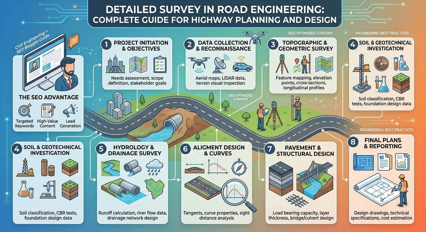
Road projects demand careful planning long before construction begins. One of the most important activities during the planning phase is the detailed survey, which provides engineers with accurate field data for designing safe, economical, and durable roads. Without reliable survey information, even the most advanced engineering design can result in costly errors, construction delays, or premature pavement failure.
In Road Engineering, a detailed survey transforms a preliminary road alignment into a precise engineering layout. It supplies measurements related to topography, soil conditions, drainage, utilities, existing infrastructure, and land features. These observations become the foundation for geometric design, earthwork calculations, pavement design, drainage planning, and cost estimation.
Whether the project involves a rural road, an urban street, or a national highway, conducting a detailed survey ensures that engineers make informed decisions throughout the project lifecycle. This guide explains the objectives, methodology, equipment, engineering principles, and practical applications of detailed surveys while highlighting industry best practices.
What Is a Detailed Survey in Road Engineering?
A detailed survey is a comprehensive field investigation conducted after the preliminary alignment has been selected. Its purpose is to gather precise horizontal and vertical measurements that engineers use to prepare final design drawings and construction documents.
Unlike a reconnaissance survey, which provides a general understanding of the project area, a detailed survey focuses on accuracy. Every feature that could influence the road design is carefully measured and recorded.
Typical information collected includes:
- Ground elevations
- Existing roads
- Rivers and streams
- Buildings
- Utility lines
- Trees and vegetation
- Drainage channels
- Property boundaries
- Bridges and culverts
- Soil conditions
These measurements allow engineers to optimize the road alignment while minimizing construction costs and environmental impacts.
Objectives of a Detailed Survey
A detailed survey serves several important engineering objectives that directly influence the success of a road project.
Develop Accurate Design Data
Engineers require reliable field measurements to prepare horizontal alignment, vertical alignment, and cross-sectional drawings.
Estimate Earthwork Quantities
Accurate elevation data helps calculate excavation and embankment volumes, enabling better project budgeting.
Support Pavement and Drainage Design
Surface levels and drainage patterns assist engineers in designing effective stormwater systems and selecting appropriate pavement structures.
Improve Construction Planning
Detailed survey data helps contractors estimate equipment requirements, construction sequences, and material quantities.
Why a Detailed Survey Is Essential
High-quality survey data forms the backbone of successful highway projects. Small measurement errors can result in significant construction problems, including incorrect earthwork volumes, poor drainage performance, and alignment deviations.
Some key benefits include:
- Improved geometric design accuracy
- Better drainage planning
- Reduced construction risks
- Lower project costs
- Faster construction progress
- Increased roadway safety
- Accurate quantity estimation
- Better coordination between engineering disciplines
Engineers often describe survey data as the “language” through which the existing ground communicates with the design team.
Types of Information Collected During a Detailed Survey
A detailed survey gathers far more than simple distance measurements. Engineers collect various categories of information to create a complete representation of the project corridor.
Topographical Data
Topographic information includes:
- Ground elevations
- Hills and valleys
- Natural slopes
- Water bodies
- Existing vegetation
- Rock outcrops
This information is essential for designing road gradients and determining earthwork requirements.
Existing Infrastructure
Surveyors record all structures that may influence the project, including:
- Roads
- Bridges
- Culverts
- Railways
- Utility poles
- Pipelines
- Transmission lines
- Buildings
Recording existing infrastructure reduces conflicts during construction.
Drainage Features
Drainage mapping identifies:
- Streams
- Rivers
- Natural watercourses
- Flood-prone areas
- Existing drainage channels
- Low-lying terrain
Understanding water movement allows engineers to design efficient drainage systems.
Property Information
Land ownership information assists in:
- Right-of-way planning
- Land acquisition
- Utility relocation
- Legal documentation
Geotechnical Observations
Although detailed soil investigations are performed separately, survey teams often identify:
- Soft ground
- Rock exposures
- Marshy areas
- Existing erosion
- Landslide-prone slopes
These observations guide future geotechnical investigations.
Equipment Used in Detailed Surveys
Modern road engineering combines traditional surveying methods with advanced digital technology to achieve exceptional accuracy.
Total Station
A Total Station measures horizontal angles, vertical angles, and distances while automatically recording field coordinates.
Applications include:
- Alignment surveys
- Setting out
- Topographic mapping
- Construction control
GPS and GNSS Receivers
Global Navigation Satellite Systems provide highly accurate positioning over large project areas.
Advantages include:
- Rapid data collection
- High positional accuracy
- Efficient corridor mapping
- Reduced field time
Digital Level
Digital levels determine precise elevations for:
- Benchmarks
- Road profiles
- Cross sections
- Drainage design
Unmanned Aerial Vehicles (Drones)
Drones are increasingly used to:
- Capture aerial imagery
- Produce orthophotos
- Generate digital terrain models
- Monitor project progress
They significantly reduce survey time on large highway projects.
Measuring Accessories
Additional equipment includes:
- Survey prisms
- Tripods
- Measuring tapes
- Range poles
- Reflectors
- Field data collectors
- Safety equipment
Proper calibration of all instruments is essential to maintain measurement accuracy.
Detailed Survey Procedure
A detailed survey follows a systematic workflow that ensures complete and reliable field data collection.
Step 1: Planning and Preparation
Before entering the field, engineers review:
- Preliminary alignment
- Existing maps
- Satellite imagery
- Design requirements
- Survey specifications
- Safety procedures
The survey team prepares equipment, establishes schedules, and identifies access routes.
Good preparation reduces field delays and improves productivity.
Step 2: Establishing Survey Control Points
Control points provide fixed reference locations for all subsequent measurements.
These points are established using precise GPS observations or existing national survey benchmarks.
Control networks ensure:
- Consistent measurements
- Accurate coordinate systems
- Reliable future construction layout
- Repeatable survey results
Permanent control markers are often protected throughout the project lifecycle.
Step 3: Topographic Survey
The topographic survey records natural and artificial features across the proposed road corridor.
Surveyors measure:
- Ground elevations
- Buildings
- Roads
- Trees
- Drainage channels
- Utility structures
- Fences
- Property boundaries
The collected data is later converted into contour maps and digital terrain models used during highway design.
Step 4: Longitudinal Profile Survey
The longitudinal profile represents ground elevations along the centerline of the proposed road.
This profile helps engineers determine:
- Road gradients
- Vertical curves
- Cut-and-fill quantities
- Drainage requirements
- Sight distances
A carefully prepared longitudinal profile contributes to a safe and economical road design.
Step 5: Cross-Section Survey
Cross sections are measured at regular intervals perpendicular to the centerline.
These measurements provide information about the terrain on both sides of the alignment.
Cross-section data is used to:
- Calculate earthwork volumes
- Design embankments
- Determine pavement widths
- Plan side slopes
- Design drainage systems
Additional cross sections may be surveyed in areas with rapidly changing terrain to improve design accuracy.
Simple Detailed Survey Workflow Diagram
Project Planning
        │
        ▼
Control Points Established
        │
        ▼
Topographic Survey
        │
        ▼
Longitudinal Profile Survey
        │
        ▼
Cross-Section Survey
        │
        ▼
Engineering Design
This structured sequence ensures that each stage builds upon reliable and accurately measured field data.
Step 6: Location of Structures and Utilities
Once the terrain has been surveyed, engineers identify all existing structures and utility services within or near the proposed road corridor. This information helps prevent conflicts during construction and supports accurate design modifications.
Typical features recorded include:
- Residential and commercial buildings
- Bridges and culverts
- Electric poles and transmission lines
- Water supply pipelines
- Sewer lines
- Gas pipelines
- Telecommunication cables
- Irrigation canals
Accurate mapping of these facilities reduces the risk of service interruptions and minimizes costly relocation work during construction.
Step 7: Drainage Survey
Water is one of the greatest threats to pavement performance. For this reason, a dedicated drainage survey is conducted to understand how surface and subsurface water moves across the project area.
Survey teams identify:
- Rivers and streams
- Natural drains
- Existing culverts
- Flood-prone locations
- Low-lying areas
- Water channels
- Seasonal watercourses
The collected information allows engineers to design side drains, culverts, bridges, and stormwater systems that effectively protect the roadway from water damage.
Step 8: Verification of Survey Data
Before design work begins, engineers carefully verify the accuracy of all collected field measurements.
This stage includes:
- Rechecking control points
- Confirming elevations
- Comparing field notes with digital data
- Identifying missing measurements
- Correcting errors
- Performing quality assurance checks
Verification reduces the possibility of costly design mistakes caused by inaccurate survey information.
Step 9: Data Processing and Digital Mapping
Modern road projects rely heavily on computer software to process survey information.
After fieldwork is completed, engineers import survey data into specialized software to prepare digital maps and engineering drawings.
Common outputs include:
- Contour maps
- Digital Terrain Models (DTM)
- Digital Elevation Models (DEM)
- Road centerline drawings
- Cross sections
- Longitudinal profiles
- Utility maps
These drawings become the foundation for highway geometric design and quantity estimation.
Step 10: Preparation of Survey Report
The final stage involves preparing a comprehensive survey report.
This document summarizes all field observations and provides the engineering team with the information needed for detailed design.
A typical report includes:
- Survey objectives
- Project location
- Survey methodology
- Equipment used
- Control point information
- Topographic maps
- Profiles and cross sections
- Utility mapping
- Drainage observations
- Recommendations for design
A well-prepared report improves communication between surveyors, designers, contractors, and project owners.
Practical Applications of Detailed Surveys
Detailed surveys play an essential role throughout the lifecycle of a road project. The collected information supports planning, design, construction, and future maintenance activities.
Highway Geometric Design
Survey data enables engineers to design safe horizontal curves, vertical curves, gradients, and intersections that meet speed and safety requirements.
Earthwork Estimation
Cross sections and ground profiles help estimate excavation and embankment quantities with greater accuracy, reducing cost overruns and material wastage.
Pavement Design
Subgrade levels and terrain information assist pavement engineers in determining suitable pavement thicknesses and material requirements.
Drainage Design
Accurate elevation data supports the design of side drains, culverts, stormwater channels, and bridge openings, reducing the risk of flooding and erosion.
Construction Layout
Survey control points are used during construction to position road centerlines, structures, and pavement edges accurately.
Asset Management
Survey records remain valuable after construction by providing reference data for maintenance, widening projects, and utility upgrades.
Engineering Principles Behind Detailed Surveys
Several engineering principles guide the execution of a detailed survey.
Accuracy
Survey measurements must meet the precision required for highway design. Even minor errors can affect alignment, earthwork calculations, and structural positioning.
Consistency
All measurements should reference the same coordinate system and benchmark elevations to ensure uniformity across the project.
Completeness
Every feature that could influence design or construction should be recorded. Missing information may result in redesigns or construction delays.
Safety
Survey operations must prioritize the safety of personnel, particularly when working near traffic, steep slopes, or waterways. Appropriate personal protective equipment (PPE), traffic control measures, and communication protocols should always be used.
Efficiency
Modern surveying techniques should balance accuracy with productivity, allowing projects to progress without compromising data quality.
Common Challenges During Detailed Surveys
Despite advances in technology, survey teams often encounter practical difficulties in the field.
Difficult Terrain
Mountainous regions, dense forests, and marshy ground can limit accessibility and increase survey time.
Adverse Weather
Heavy rainfall, fog, and extreme temperatures may reduce visibility, affect equipment performance, and delay fieldwork.
Utility Congestion
Urban areas often contain numerous underground and overhead utilities that require careful identification and coordination.
Restricted Access
Private properties, protected areas, or military zones may require special permissions before surveys can begin.
Instrument Errors
Poor calibration, equipment damage, or operator mistakes can introduce measurement inaccuracies if not identified promptly.
Proper planning and regular equipment checks help minimize these challenges.
Best Practices for Conducting Detailed Surveys
Successful survey projects follow established engineering practices to ensure reliable results.
- Review project requirements before entering the field.
- Calibrate survey instruments regularly.
- Establish stable and protected control points.
- Verify critical measurements through repeat observations.
- Maintain accurate field notes and digital backups.
- Use drones and GNSS technology where appropriate.
- Coordinate survey activities with utility agencies and local authorities.
- Follow safety procedures at all times.
- Process data promptly to identify missing information.
- Conduct independent quality checks before issuing the final survey report.
Practical Recommendations
Civil Engineers
- Validate survey data before starting geometric or pavement design.
- Coordinate with geotechnical and drainage specialists to ensure complete site information.
- Review contour maps carefully to optimize alignment and reduce earthwork.
Contractors
- Confirm survey control points before commencing construction.
- Protect established benchmarks from damage during site activities.
- Use updated survey information for setting out and quality control.
Engineering Students
- Develop proficiency in Total Station, GNSS, and digital level operations.
- Learn how to interpret contour maps, profiles, and cross sections.
- Gain practical field experience through internships or educational site visits.
- Understand how survey accuracy influences every stage of road engineering.
General Discussion of IRC, AASHTO, and ICE Practices
International highway engineering organizations emphasize the importance of accurate surveys as the foundation of successful infrastructure projects.
In general:
- IRC (Indian Roads Congress) recommends comprehensive topographic, traffic, drainage, and geotechnical data collection before preparing detailed highway designs.
- AASHTO (American Association of State Highway and Transportation Officials) promotes precise survey control, reliable terrain mapping, and integration of survey information into geometric and pavement design.
- ICE (Institution of Civil Engineers) encourages rigorous surveying standards, quality assurance, and the adoption of modern technologies to improve project efficiency and long-term infrastructure performance.
Although project specifications vary by country, these organizations share the common objective of improving safety, durability, sustainability, and cost-effectiveness through accurate engineering surveys.
Frequently Asked Questions (FAQs)
1. What is a detailed survey in road engineering?
A detailed survey is a comprehensive field investigation that collects precise topographic, geometric, utility, and drainage data required for the final design and construction of roads.
2. Why is a detailed survey important before road construction?
It provides accurate information for geometric design, earthwork calculations, drainage planning, pavement design, and construction layout while reducing errors and project risks.
3. Which instruments are commonly used for detailed surveys?
Common equipment includes Total Stations, GNSS receivers, digital levels, drones, measuring tapes, prisms, and data collectors.
4. What is the difference between a preliminary survey and a detailed survey?
A preliminary survey identifies possible alignments and assesses project feasibility, whereas a detailed survey gathers precise measurements needed for final engineering design.
5. How does a detailed survey improve construction quality?
Accurate survey data ensures correct alignment, proper elevations, reliable quantity estimates, and precise positioning of structures during construction.
6. What information is included in a survey report?
A survey report typically contains project details, methodology, control points, topographic maps, profiles, cross sections, utility information, drainage observations, and engineering recommendations.
7. Why are control points established during a detailed survey?
Control points provide fixed reference locations that ensure consistent and accurate measurements throughout the project lifecycle.
8. Can drones replace traditional surveying methods?
Drones significantly improve efficiency and aerial mapping capabilities, but they complement rather than completely replace ground surveys, especially where high-precision measurements are required.
9. What are the biggest challenges during detailed surveys?
Common challenges include difficult terrain, adverse weather, restricted site access, dense utilities, and maintaining instrument accuracy.
10. How does a detailed survey support long-term road maintenance?
Survey records provide baseline data that can be used for future widening, rehabilitation, maintenance planning, utility upgrades, and monitoring changes in roadway conditions.
Conclusion
A detailed survey is one of the most critical stages in Road Engineering, providing the accurate field information required to transform a proposed alignment into a safe, efficient, and constructible roadway. From establishing control points and mapping topography to identifying utilities, analyzing drainage, and preparing digital terrain models, every activity contributes to informed engineering decisions. Reliable survey data improves geometric design, reduces construction risks, enhances quantity estimation, and supports effective project management throughout the infrastructure lifecycle.
Modern technologies such as GNSS, Total Stations, drones, and digital mapping software have significantly increased survey accuracy and efficiency, but experienced engineering judgment remains equally important. By following recognized industry practices and maintaining strict quality control, engineers and contractors can minimize costly errors and deliver sustainable transportation infrastructure. For students, mastering detailed survey techniques provides a strong foundation for understanding the broader principles of Road Engineering and developing successful careers in highway planning, design, and construction.

Kamran Malik is a passionate civil engineering writer and researcher who specializes in construction, transportation, structural engineering, and infrastructure topics. Through his articles on CivilEngineerings.com, he simplifies complex engineering concepts and shares practical insights, industry trends, and educational resources for students, professionals, and engineering enthusiasts.