
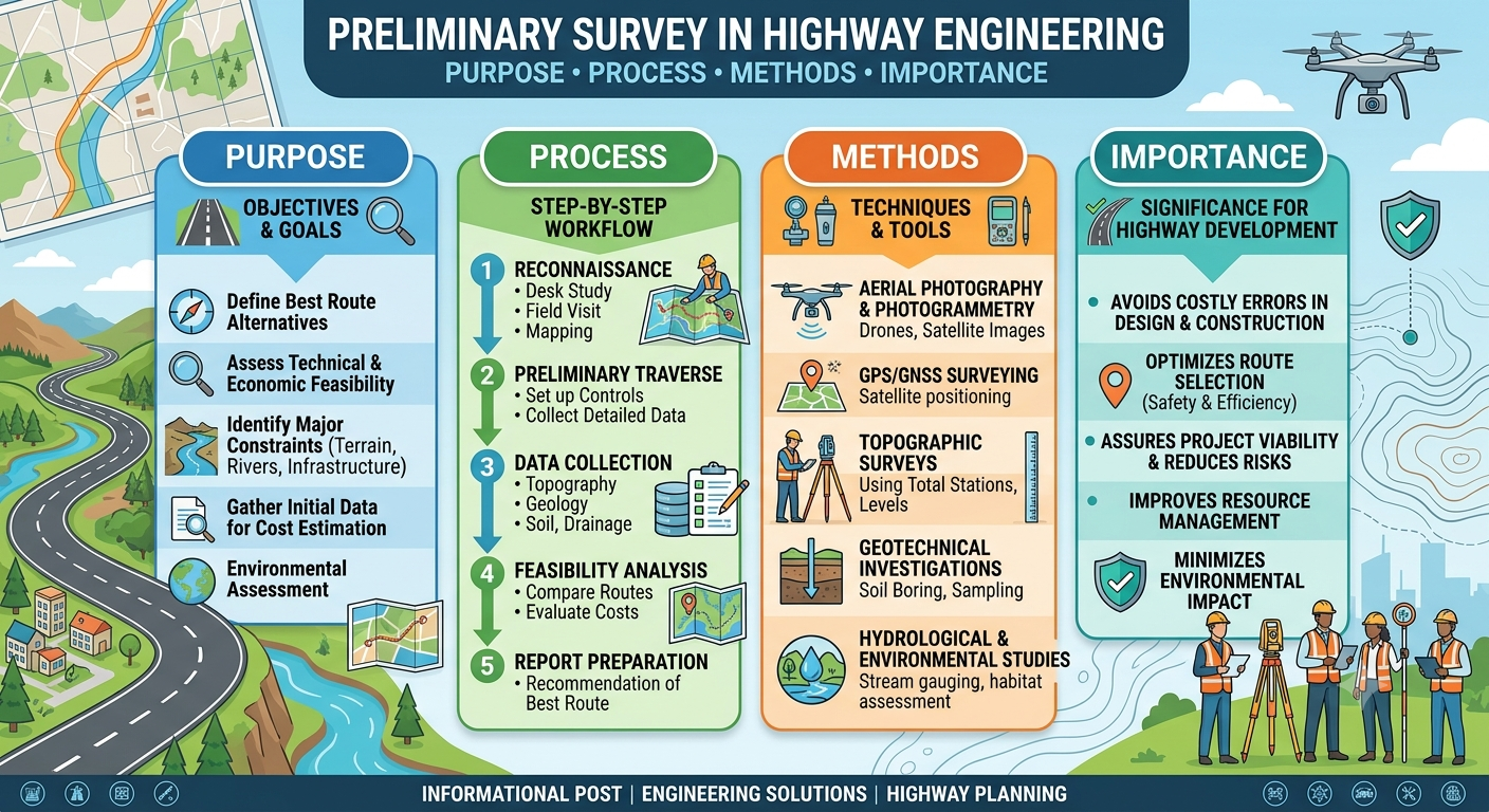
Highway projects do not begin with excavation, paving, or bridge construction. Long before heavy machinery reaches the site, engineers conduct a series of investigations to determine whether a proposed route is technically feasible, economically viable, environmentally responsible, and safe for future traffic. Among these investigations, the Preliminary Survey is one of the most important phases of highway planning.
A preliminary survey provides engineers with the information needed to compare alternative alignments, estimate construction costs, identify engineering challenges, and prepare a suitable design for the proposed highway. It bridges the gap between the reconnaissance survey and the final location survey, allowing informed decisions before significant investments are made.
Whether you are a civil engineering student, transportation engineer, highway consultant, or contractor, understanding the Preliminary Survey process is essential for successful road infrastructure development. This guide explains its objectives, procedures, engineering principles, field activities, equipment, and practical applications using industry best practices.
What Is a Preliminary Survey?
A Preliminary Survey is a detailed engineering investigation carried out after the reconnaissance survey and before the final location survey. Its purpose is to collect accurate technical data for evaluating possible highway alignments and selecting the most suitable route.
Unlike a reconnaissance survey, which mainly involves visual inspections and broad observations, a preliminary survey includes detailed measurements, mapping, soil investigations, hydrological assessments, and traffic studies. The information gathered enables engineers to prepare preliminary designs, estimate project costs, and compare multiple route alternatives.
The survey serves as the technical foundation for future design work and significantly reduces the likelihood of costly modifications during construction.
Definition of Preliminary Survey
In highway engineering, a preliminary survey is the systematic collection of topographic, geotechnical, environmental, hydrological, and traffic information to assess the feasibility of one or more proposed highway alignments.
Role in Highway Project Development
The preliminary survey supports several important decisions, including:
- Selecting the safest and most economical route.
- Identifying engineering constraints.
- Estimating earthwork quantities.
- Evaluating bridge and culvert requirements.
- Preparing preliminary construction estimates.
- Assessing environmental and social impacts.
Objectives of a Preliminary Survey
Every preliminary survey has clearly defined objectives that guide the planning and design process.
The primary objectives include:
- Collecting accurate engineering data.
- Evaluating alternative highway routes.
- Determining ground elevations.
- Investigating soil conditions.
- Assessing drainage requirements.
- Estimating construction costs.
- Supporting preliminary geometric design.
- Providing reliable information for project approval.
A carefully executed survey allows engineers to minimize technical risks while optimizing project performance and cost.
Importance of a Preliminary Survey
The success of a highway project depends heavily on the quality of information collected during the planning stage. Decisions made using inaccurate or incomplete data often result in expensive redesigns, construction delays, or operational problems after completion.
A well-executed preliminary survey provides several important benefits:
- Improves route selection.
- Reduces construction uncertainties.
- Supports accurate quantity estimation.
- Minimizes environmental impacts.
- Enhances road safety.
- Reduces overall project costs.
- Improves design accuracy.
- Facilitates better resource planning.
Practical Example
Suppose engineers are planning a new highway connecting two industrial cities. Three possible routes are available.
- Route A passes through mountainous terrain.
- Route B crosses agricultural land with several rivers.
- Route C follows relatively flat ground but requires additional land acquisition.
By conducting a preliminary survey for each alternative, engineers can compare construction costs, earthwork quantities, environmental impacts, drainage requirements, and long-term maintenance needs before selecting the most practical alignment.
Stages of a Preliminary Survey
A preliminary survey is completed in several organized stages to ensure that all relevant engineering information is collected systematically.
Review of Reconnaissance Findings
The process begins by reviewing observations made during the reconnaissance survey.
Engineers study:
- Preliminary route sketches.
- Satellite imagery.
- Existing road networks.
- Geological maps.
- Topographic maps.
- Land-use information.
This review helps identify areas requiring detailed investigation.
Detailed Field Investigation
Field teams visit each proposed alignment to collect accurate measurements.
Activities commonly include:
- Measuring ground levels.
- Recording natural features.
- Locating rivers and streams.
- Identifying existing utilities.
- Mapping buildings and structures.
- Recording vegetation and land cover.
Modern surveying technologies improve both accuracy and efficiency during this stage.
Route Comparison
After collecting field data, engineers compare the proposed routes based on several technical and economic factors.
Evaluation criteria typically include:
- Alignment length.
- Earthwork quantities.
- Number of bridges.
- Drainage requirements.
- Soil conditions.
- Construction cost.
- Environmental impacts.
- Future expansion potential.
Selecting the best route requires balancing engineering performance with economic feasibility.
Preliminary Design Preparation
Once the preferred alignment is selected, engineers prepare a preliminary design that includes:
- Horizontal alignment.
- Vertical profile.
- Typical cross-sections.
- Preliminary pavement design.
- Drainage concepts.
- Initial cost estimates.
This design forms the basis for further detailed engineering.
Activities Performed During a Preliminary Survey
Several specialized investigations are conducted during a preliminary survey.
Topographic Survey
Topographic surveying determines the physical characteristics of the land.
Engineers collect information on:
- Ground elevations.
- Slopes.
- Hills and valleys.
- Rivers.
- Existing roads.
- Buildings.
- Utility corridors.
The resulting contour maps help engineers design safe and economical highway alignments.
Geotechnical Investigation
Understanding subsurface conditions is essential for designing stable pavements and structures.
Typical investigations include:
- Borehole drilling.
- Trial pits.
- Soil sampling.
- Laboratory testing.
- Groundwater observations.
Common laboratory tests include:
- Grain Size Analysis.
- Atterberg Limits.
- California Bearing Ratio (CBR).
- Proctor Compaction Test.
- Shear Strength Tests.
The findings influence pavement thickness, embankment design, and foundation selection.
Hydrological Study
Drainage is a key consideration during highway planning.
Hydrological investigations identify:
- Rivers.
- Streams.
- Flood-prone areas.
- Watersheds.
- Surface runoff patterns.
- Groundwater conditions.
The collected data assists in designing:
- Culverts.
- Bridges.
- Side drains.
- Stormwater channels.
Proper drainage design reduces erosion and extends pavement life.
Traffic Data Collection
Traffic surveys help engineers determine future transportation requirements.
Information collected may include:
- Average Daily Traffic (ADT).
- Vehicle classification.
- Peak-hour traffic.
- Heavy vehicle percentage.
- Travel speed.
- Accident history.
Traffic forecasts support decisions regarding lane requirements, pavement design, and intersection layouts.
Environmental Assessment
Although a comprehensive Environmental Impact Assessment may occur later, preliminary surveys include an initial environmental review.
Engineers identify:
- Forest areas.
- Wetlands.
- Wildlife habitats.
- Agricultural land.
- Historical sites.
- Residential communities.
Early identification of sensitive areas helps reduce environmental impacts and avoid future project delays.
Survey Equipment Used
Modern preliminary surveys rely on advanced equipment that improves measurement accuracy and project efficiency.
Common instruments include:
- Total Station
- Global Navigation Satellite System (GNSS) Receiver
- GPS Survey Equipment
- Digital Level
- Drone (UAV)
- Laser Scanner (LiDAR)
- Soil Sampling Equipment
- Measuring Wheel
- Range Finder
- Compass
Each instrument serves a specific purpose and contributes to producing accurate engineering data.
Engineering Principles Behind a Preliminary Survey
A preliminary survey applies several fundamental engineering principles to ensure that the proposed highway is safe, economical, and sustainable.
Key principles include:
- Accuracy in data collection.
- Optimization of route alignment.
- Efficient earthwork balancing.
- Adequate drainage planning.
- Geometric design consistency.
- Environmental stewardship.
- Cost-effectiveness.
- Long-term serviceability.
These principles guide engineers in selecting alignments that provide the best balance between construction costs, operational efficiency, and user safety.
Diagram: Preliminary Survey Workflow
Project Approval
        │
        ▼
Reconnaissance Survey
        │
        ▼
Preliminary Survey
        │
 ┌──────┼──────┐
 │      │      │
 ▼      ▼      ▼
Topographic  Geotechnical  Traffic
Survey       Investigation  Studies
        │
        ▼
Hydrological &
Environmental Review
        │
        ▼
Route Comparison
        │
        ▼
Preliminary Design
        │
        ▼
Final Location Survey
Data Analysis and Route Comparison
Once field investigations are complete, engineers organize and evaluate the collected information to identify the most suitable highway alignment. This stage transforms raw survey data into practical engineering decisions that influence project cost, safety, and long-term performance.
Rather than selecting the shortest route, engineers compare several alternatives using technical, environmental, and economic criteria.
Key Factors Considered During Route Comparison
1. Terrain and Topography
The natural landscape directly affects construction complexity. Routes across flat terrain generally require less excavation and embankment work than mountainous areas, making them more economical.
2. Soil and Geological Conditions
Geotechnical findings help engineers identify weak soils, expansive clay, rock formations, or landslide-prone areas. Alignments passing through stable ground usually reduce foundation costs and future maintenance requirements.
3. Hydrological Conditions
The number of rivers, streams, floodplains, and drainage crossings along each route significantly influences project cost. Alignments requiring fewer bridges and culverts are often preferred, provided other engineering requirements are satisfied.
4. Environmental Impact
Survey data helps determine whether a route passes through forests, wetlands, wildlife habitats, agricultural land, or environmentally sensitive zones. Engineers strive to minimize ecological disturbance while meeting transportation objectives.
5. Economic Considerations
Construction cost estimates include:
- Earthwork quantities
- Bridge construction
- Pavement materials
- Utility relocation
- Land acquisition
- Drainage structures
Although a shorter alignment may appear attractive, additional engineering challenges can increase the overall project cost.
6. Future Expansion Potential
A well-planned route should accommodate future traffic growth, additional lanes, service roads, or utility corridors without major reconstruction.
Practical Applications of a Preliminary Survey
The information collected during a preliminary survey is used throughout the project lifecycle. It supports decision-making long before construction begins and continues to guide engineers during design and execution.
Highway Planning
Survey data enables transportation agencies to determine the most practical corridor while balancing engineering performance, environmental protection, and project costs.
Pavement Design
Subgrade strength, groundwater conditions, and traffic forecasts obtained during the survey assist pavement engineers in selecting appropriate pavement types and layer thicknesses.
Bridge and Culvert Design
Hydrological investigations identify drainage requirements, allowing structural engineers to determine suitable bridge locations and culvert sizes.
Earthwork Planning
Topographic surveys help estimate excavation and embankment quantities, enabling contractors to plan equipment, materials, and construction schedules more efficiently.
Cost Estimation
Reliable survey information improves the accuracy of Bills of Quantities (BOQs), reducing the likelihood of budget overruns during construction.
Common Challenges During a Preliminary Survey
Even with modern technology, engineers encounter several challenges while conducting preliminary surveys.
Difficult Terrain
Mountainous regions, dense forests, marshlands, and remote areas can make surveying difficult and time-consuming.
Solution: Use drones, satellite imagery, GNSS receivers, and LiDAR technology to improve accessibility and data accuracy.
Inaccurate Existing Maps
Older topographic maps may no longer reflect current land use, infrastructure, or natural features.
Solution: Verify existing information through detailed field surveys and updated aerial imagery.
Adverse Weather Conditions
Heavy rainfall, flooding, or extreme temperatures can delay survey operations and affect measurement accuracy.
Solution: Schedule critical fieldwork during favorable weather conditions and maintain flexible project timelines.
Utility Conflicts
Underground pipelines, power lines, communication cables, and water supply networks may interfere with the proposed alignment.
Solution: Coordinate with utility authorities early in the planning process to identify and resolve potential conflicts.
Environmental Restrictions
Protected forests, wildlife habitats, archaeological sites, and wetlands often limit alignment options.
Solution: Integrate environmental specialists into the survey team and evaluate environmentally responsible alternatives.
Best Practices for Conducting a Preliminary Survey
Applying proven engineering practices improves both the quality of survey data and the overall success of highway projects.
- Begin with a thorough review of reconnaissance survey findings.
- Use calibrated surveying instruments to ensure measurement accuracy.
- Collect sufficient soil samples at representative locations.
- Verify field observations using multiple data sources.
- Document all survey activities with photographs and field notes.
- Consider long-term traffic growth rather than current demand alone.
- Evaluate multiple route alternatives before selecting the preferred alignment.
- Coordinate survey activities with geotechnical, environmental, and structural specialists.
- Maintain accurate digital records for future reference.
- Conduct regular quality assurance checks throughout the survey process.
Practical Recommendations
Civil Engineers
- Validate survey data before beginning highway design.
- Integrate geotechnical, hydrological, and traffic information into alignment selection.
- Use modern survey software to improve data processing and visualization.
- Review alternative routes objectively using technical and economic criteria.
Contractors
- Study survey reports carefully before preparing construction plans.
- Confirm site conditions during mobilization to identify any changes since the survey.
- Coordinate with survey teams to minimize construction errors.
- Protect survey control points throughout construction activities.
Engineering Students
- Develop a strong understanding of surveying fundamentals and highway planning principles.
- Gain practical experience with Total Stations, GNSS equipment, and digital levels.
- Learn to interpret contour maps, longitudinal profiles, and cross-sections.
- Participate in field visits to understand how survey data influences engineering decisions.
General Discussion of IRC, AASHTO, and ICE Practices
Recognized highway engineering organizations such as IRC (Indian Roads Congress), AASHTO (American Association of State Highway and Transportation Officials), and ICE (Institution of Civil Engineers) emphasize the importance of reliable survey data during transportation planning.
Although their detailed standards differ, they share several common principles:
- Carry out comprehensive topographic and geotechnical investigations before detailed design.
- Base alignment decisions on technical, economic, environmental, and safety considerations.
- Use accurate surveying methods and modern measurement technologies.
- Integrate drainage planning during the early stages of highway development.
- Consider future traffic demand when evaluating route alternatives.
- Maintain proper documentation and quality assurance throughout the survey process.
- Encourage multidisciplinary collaboration among surveyors, transportation engineers, geotechnical specialists, and environmental professionals.
These widely accepted engineering practices contribute to safer, more durable, and cost-effective highway infrastructure.
Frequently Asked Questions (FAQs)
1. What is a preliminary survey in highway engineering?
A preliminary survey is a detailed investigation conducted after the reconnaissance survey to collect technical data required for evaluating alternative highway alignments and preparing preliminary designs.
2. Why is a preliminary survey important?
It provides accurate information for route selection, cost estimation, pavement design, drainage planning, and environmental assessment while reducing construction risks.
3. What is the difference between a reconnaissance survey and a preliminary survey?
A reconnaissance survey involves general observations to identify possible routes, whereas a preliminary survey collects detailed engineering data through measurements, investigations, and technical analysis.
4. Which surveys are conducted during a preliminary survey?
Typical investigations include topographic surveys, geotechnical investigations, hydrological studies, traffic surveys, and preliminary environmental assessments.
5. Which equipment is commonly used?
Engineers frequently use Total Stations, GNSS receivers, GPS equipment, digital levels, drones, LiDAR systems, soil sampling tools, and measuring instruments.
6. How does a preliminary survey improve highway safety?
Accurate survey data helps engineers design appropriate curves, gradients, drainage systems, and pavement structures, reducing the likelihood of operational and structural problems.
7. Who performs a preliminary survey?
The work is typically carried out by multidisciplinary teams that include surveyors, civil engineers, transportation engineers, geotechnical engineers, environmental specialists, and GIS professionals.
8. What happens after the preliminary survey?
Once the preferred alignment is selected, engineers proceed with the final location survey, detailed engineering design, land acquisition, and construction planning.
9. Can modern technology replace traditional surveying methods?
Modern tools such as drones, GNSS, and LiDAR significantly improve efficiency and accuracy, but field verification remains essential to confirm site conditions and engineering assumptions.
10. How does a preliminary survey reduce project costs?
Accurate data minimizes design revisions, improves quantity estimates, identifies potential risks early, and helps engineers choose the most economical and technically feasible alignment.
Conclusion
A Preliminary Survey is one of the most important stages in highway planning because it provides the detailed engineering information required to transform an initial concept into a practical infrastructure project. By collecting accurate topographic, geotechnical, hydrological, environmental, and traffic data, engineers can evaluate alternative routes, estimate construction costs, and identify technical challenges before detailed design begins. This systematic approach minimizes uncertainty, improves decision-making, and reduces the likelihood of expensive modifications during construction. Modern surveying technologies have greatly enhanced the speed and accuracy of data collection, yet engineering judgment remains essential when interpreting results and selecting the most suitable alignment. Whether you are a civil engineer, transportation consultant, contractor, or engineering student, understanding the Preliminary Survey process will strengthen your ability to plan safer, more economical, and sustainable highway projects that meet present transportation needs while supporting future development.

Kamran Malik is a passionate civil engineering writer and researcher who specializes in construction, transportation, structural engineering, and infrastructure topics. Through his articles on CivilEngineerings.com, he simplifies complex engineering concepts and shares practical insights, industry trends, and educational resources for students, professionals, and engineering enthusiasts.