
Introduction
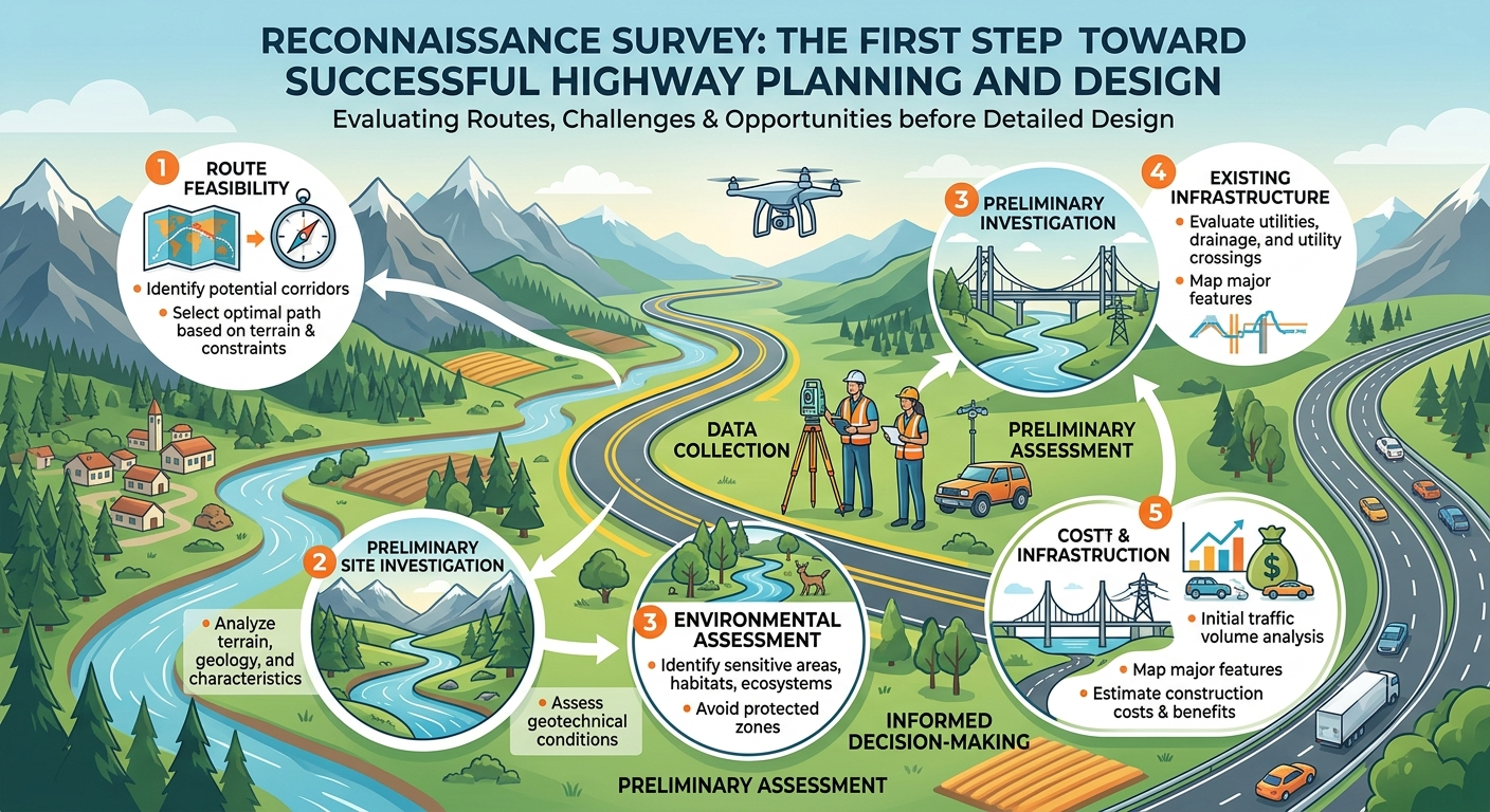
Every successful highway, expressway, railway, or major infrastructure project begins with careful planning, and one of the earliest activities in this process is the Reconnaissance Survey. Before engineers perform detailed surveys or prepare engineering drawings, they must understand the physical characteristics of the proposed project area. A reconnaissance survey provides this initial understanding by identifying feasible routes, evaluating terrain conditions, and highlighting potential engineering challenges.
In highway engineering, decisions made during the preliminary planning stage have a significant impact on construction costs, environmental sustainability, project safety, and long-term performance. Conducting a well-planned reconnaissance survey helps engineers compare multiple route alternatives, reduce project risks, and optimize resource utilization before investing in detailed investigations.
Whether you are a civil engineer, transportation engineer, contractor, or engineering student, understanding the purpose and methodology of a reconnaissance survey is essential. This guide explains its objectives, methods, engineering principles, equipment, and practical applications while incorporating industry best practices and recognized concepts commonly followed in modern highway engineering.
What Is a Reconnaissance Survey?
A Reconnaissance Survey is a preliminary engineering survey conducted to obtain general information about a proposed project area before detailed investigations begin. Its primary purpose is to identify suitable route alternatives, understand site conditions, and determine whether a project is technically, economically, and environmentally feasible.
Unlike detailed surveys, which involve precise measurements and engineering calculations, a reconnaissance survey focuses on collecting broad information through field observations, existing maps, satellite imagery, and preliminary investigations.
This survey acts as the foundation for subsequent stages such as preliminary surveys, detailed design, and construction planning.
Definition
A reconnaissance survey is the systematic inspection of a proposed project corridor to evaluate terrain, topography, geology, drainage, land use, environmental constraints, and existing infrastructure before selecting the most suitable alignment.
Key Characteristics
- Conducted during the earliest planning stage.
- Covers a relatively large project area.
- Uses approximate measurements rather than precise data.
- Identifies multiple feasible route options.
- Minimizes future design changes.
- Supports informed engineering decisions.
Why Is a Reconnaissance Survey Important?
Selecting an unsuitable route can significantly increase construction costs, create environmental issues, and shorten the service life of a highway. A reconnaissance survey helps engineers avoid these problems by identifying potential constraints before detailed design begins.
Proper reconnaissance reduces uncertainty and improves project planning.
Benefits for Highway Projects
- Identifies technically feasible alignments.
- Reduces unnecessary earthwork.
- Minimizes bridge and culvert requirements.
- Helps avoid unstable soil conditions.
- Protects environmentally sensitive areas.
- Reduces project costs.
- Improves construction efficiency.
- Supports safer highway design.
Impact on Cost and Safety
For example, selecting a route that crosses multiple rivers may require several expensive bridges. During reconnaissance, engineers may identify an alternative alignment with fewer crossings, resulting in substantial savings while simplifying construction and future maintenance.
Similarly, avoiding landslide-prone slopes or flood-prone areas enhances long-term safety and reduces maintenance requirements.
When Is a Reconnaissance Survey Conducted?
A reconnaissance survey is generally performed immediately after identifying the need for a new transportation project and before conducting detailed topographic or geotechnical surveys.
Typical projects requiring reconnaissance surveys include:
- National highways
- Expressways
- Rural roads
- Urban bypasses
- Railway corridors
- Airport access roads
- Industrial roads
- Canal alignments
Conducting reconnaissance early allows project teams to eliminate unsuitable alternatives before investing significant time and financial resources.
Objectives of a Reconnaissance Survey
The primary objective is to gather sufficient information for selecting the most appropriate project corridor.
Specific objectives include:
- Identify possible route alternatives.
- Evaluate terrain characteristics.
- Assess topographic conditions.
- Observe drainage patterns.
- Locate rivers, streams, and water bodies.
- Identify existing roads and infrastructure.
- Examine geological conditions.
- Detect environmental constraints.
- Estimate construction difficulties.
- Identify locations requiring bridges or retaining structures.
- Provide input for feasibility studies.
- Support preliminary cost estimation.
These objectives enable engineers to compare different route options based on technical, environmental, and economic considerations.
Step-by-Step Reconnaissance Survey Process
A systematic approach ensures that all relevant information is collected efficiently.
Step 1: Collect Existing Information
Before visiting the site, engineers gather available information from various sources, including:
- Topographic maps
- Satellite imagery
- Aerial photographs
- GIS databases
- Geological maps
- Hydrological records
- Existing road network plans
Studying existing data helps engineers understand the general characteristics of the area and identify locations requiring special attention during field inspections.
Step 2: Site Visit and Visual Inspection
Field visits provide valuable information that may not appear on maps or satellite images.
During the inspection, engineers observe:
- Hills and valleys
- Rivers and streams
- Existing roads
- Buildings
- Agricultural land
- Forests
- Rock outcrops
- Utilities
- Potential construction obstacles
Photographs and field notes are recorded for later evaluation.
Step 3: Identify Alternative Routes
Instead of selecting the first available route, engineers compare several alternatives.
Each alignment is evaluated based on:
- Length
- Construction cost
- Earthwork requirements
- Bridge requirements
- Environmental impacts
- Land acquisition
- Future expansion opportunities
Comparing alternatives helps identify the most balanced solution.
Step 4: Record Field Observations
All observations should be documented carefully.
Typical records include:
- GPS coordinates
- Terrain descriptions
- Soil observations
- Existing drainage
- Vegetation
- Nearby settlements
- Utility crossings
- Photographs
- Sketches
Accurate documentation improves communication among designers, planners, and project stakeholders.
Methods of Reconnaissance Survey
Engineers use several methods depending on project size, terrain, and available technology.
Ground Reconnaissance
The traditional approach involves walking or driving along the proposed corridor while recording observations.
Advantages:
- Direct visual inspection.
- Immediate identification of obstacles.
- Better understanding of terrain.
Aerial Reconnaissance
Drones, helicopters, or aircraft capture aerial imagery over large areas.
Benefits include:
- Faster coverage.
- Better visualization of terrain.
- Access to difficult locations.
- High-resolution imagery.
Satellite Image Analysis
Modern GIS software and satellite imagery help engineers identify:
- Land use
- Water bodies
- Forests
- Urban development
- Terrain features
This method is especially useful during the initial planning phase.
Equipment Used During a Reconnaissance Survey
Although detailed survey equipment is not always required, engineers commonly use:
- GPS receiver
- Drone (UAV)
- Digital camera
- Measuring tape
- Compass
- Hand level
- Clinometer
- Binoculars
- Field notebook
- Mobile GIS applications
- Tablet or laptop
- Topographic maps
Modern technologies such as drones and GIS software have significantly improved the speed and accuracy of reconnaissance surveys.
Engineering Principles Behind Reconnaissance Surveys
Several engineering principles guide the selection of a suitable highway corridor.
Economy
The preferred alignment should minimize construction, maintenance, and operating costs while meeting project objectives.
Safety
Routes should provide adequate sight distance, gentle curves, and stable terrain to reduce accident risks.
Constructability
Engineers evaluate whether the proposed route can be constructed efficiently using available equipment, materials, and labor.
Sustainability
Environmental impacts should be minimized by avoiding protected ecosystems, wetlands, and densely populated areas whenever practical.
Future Expansion
The selected corridor should accommodate anticipated traffic growth and future widening if necessary.
Practical Example
Suppose a transportation agency plans a new four-lane highway connecting two growing cities.
During the reconnaissance survey, engineers examine three possible alignments:
- Route A passes through steep hills, requiring extensive excavation and several retaining walls.
- Route B crosses fertile agricultural land with relatively flat terrain but involves significant land acquisition.
- Route C follows gently rolling terrain, avoids major rivers, minimizes environmental impacts, and connects existing transportation corridors.
Although Route C is slightly longer, it offers lower construction costs, fewer environmental concerns, and simpler maintenance requirements. Based on the reconnaissance findings, engineers recommend Route C for further investigation.
Simple Route Selection Diagram
Project Start
      │
      ▼
Collect Existing Maps & Data
      │
      ▼
Field Reconnaissance
      │
      ▼
Identify Alternative Routes
      │
      ▼
Evaluate Engineering Constraints
      │
      ▼
Select Preferred Corridor
      │
      ▼
Proceed to Preliminary Survey
Factors Considered During a Reconnaissance Survey
Selecting the most suitable route requires engineers to evaluate numerous technical, environmental, and economic factors. Rather than focusing on a single criterion, they assess the project corridor from multiple perspectives to ensure the chosen alignment delivers long-term value.
Terrain and Topography
Terrain has a direct influence on highway design and construction costs. Engineers study the natural landscape to identify:
- Hills and ridges
- Valleys and low-lying areas
- Natural slopes
- Elevation changes
- Rocky outcrops
A route with gentle gradients generally requires less excavation and filling, making construction more economical.
Geological Conditions
Understanding the geological characteristics of the project area helps engineers anticipate construction challenges.
Important observations include:
- Soil types
- Rock formations
- Fault zones
- Landslide-prone areas
- Expansive clay deposits
- Weak foundation soils
Avoiding unstable ground reduces future maintenance costs and improves pavement performance.
Drainage and Hydrology
Water is one of the leading causes of pavement deterioration. During reconnaissance, engineers identify:
- Rivers
- Streams
- Seasonal watercourses
- Flood-prone regions
- Wetlands
- Existing drainage channels
These observations help determine suitable locations for culverts, bridges, and stormwater drainage systems.
Existing Infrastructure
A highway should integrate efficiently with the surrounding transportation network.
Engineers identify:
- Existing highways
- Railways
- Utility lines
- Pipelines
- Bridges
- Airports
- Industrial zones
Connecting with existing infrastructure improves accessibility while reducing unnecessary construction.
Environmental Considerations
Modern highway planning places strong emphasis on environmental protection.
During reconnaissance, engineers assess:
- Forest areas
- Wildlife habitats
- Protected parks
- Wetlands
- Agricultural land
- Historical and archaeological sites
Early identification of environmentally sensitive areas allows planners to modify alignments before detailed design begins.
Social and Economic Factors
Infrastructure projects directly affect nearby communities.
Engineers evaluate:
- Population density
- Residential developments
- Commercial centers
- Schools and hospitals
- Future urban expansion
- Local economic activities
Selecting a route with minimal social disruption often improves project acceptance and reduces land acquisition challenges.
Advantages of a Reconnaissance Survey
A well-executed reconnaissance survey offers numerous engineering and economic benefits.
Improved Route Selection
Comparing multiple alternatives enables engineers to identify the most practical and economical alignment.
Reduced Construction Costs
Early identification of engineering constraints helps avoid expensive modifications during construction.
Better Risk Management
Potential hazards such as unstable slopes, weak soils, flooding, or utility conflicts can be recognized before detailed design.
Faster Project Planning
Reliable preliminary information accelerates decision-making and streamlines subsequent survey stages.
Enhanced Environmental Protection
Sensitive ecological areas can be avoided, reducing environmental impacts and facilitating regulatory approvals.
Improved Stakeholder Communication
Reconnaissance findings provide valuable information for discussions with government agencies, landowners, consultants, and contractors.
Limitations of a Reconnaissance Survey
Although reconnaissance surveys provide valuable preliminary information, they also have certain limitations.
- Measurements are approximate rather than highly accurate.
- Underground conditions cannot be fully evaluated without geotechnical investigations.
- Seasonal weather conditions may influence field observations.
- Hidden utilities or subsurface obstacles may remain undetected.
- Detailed design cannot be prepared using reconnaissance data alone.
For these reasons, reconnaissance surveys should always be followed by preliminary and detailed engineering surveys.
Common Mistakes to Avoid
Even experienced engineering teams can encounter problems if reconnaissance activities are not performed systematically.
Some common mistakes include:
- Relying solely on satellite imagery without conducting field visits.
- Ignoring local drainage patterns.
- Underestimating future traffic growth.
- Overlooking environmental constraints.
- Failing to compare multiple route alternatives.
- Inadequate documentation of field observations.
- Neglecting discussions with local communities.
- Assuming existing maps are completely up to date.
Avoiding these errors improves project quality and minimizes redesign during later stages.
Best Practices for Conducting a Reconnaissance Survey
Professional engineering organizations encourage a structured and evidence-based approach to reconnaissance.
Recommended best practices include:
- Review all available maps and historical records before fieldwork.
- Visit the site during different weather conditions whenever practical.
- Use drones and GIS software to complement ground inspections.
- Record GPS coordinates for key observations.
- Capture photographs from multiple viewpoints.
- Document all engineering constraints systematically.
- Evaluate several alignment alternatives instead of focusing on one route.
- Coordinate with geotechnical, environmental, and transportation specialists.
- Maintain detailed field notes for future reference.
- Consider long-term maintenance requirements during route selection.
Following these practices improves the quality of engineering decisions and reduces uncertainty during project development.
Practical Recommendations
Civil Engineers
- Combine field observations with digital mapping technologies.
- Prioritize safety, constructability, and lifecycle costs during alignment selection.
- Verify reconnaissance findings during subsequent surveys.
- Collaborate with multidisciplinary teams to identify potential risks early.
Contractors
- Review reconnaissance reports carefully before preparing construction plans.
- Identify potential equipment access challenges during site visits.
- Assess the availability of nearby construction materials and borrow areas.
- Plan temporary access roads where necessary.
Engineering Students
- Learn how reconnaissance surveys fit within the complete highway planning process.
- Develop skills in reading topographic maps and satellite imagery.
- Gain practical experience using GPS devices and GIS software.
- Study completed highway projects to understand how early planning influences final outcomes.
General Discussion of IRC, AASHTO, and ICE Practices
Internationally recognized engineering organizations emphasize the importance of thorough reconnaissance during transportation planning.
IRC (Indian Roads Congress)
IRC guidance encourages engineers to conduct comprehensive field inspections before finalizing highway alignments. General recommendations include evaluating terrain, drainage, traffic demand, environmental constraints, and future development while comparing multiple route alternatives.
AASHTO (American Association of State Highway and Transportation Officials)
AASHTO promotes a planning process that integrates transportation needs, safety, environmental stewardship, and cost-effectiveness. Early corridor evaluation and reliable field information contribute to more sustainable and efficient highway designs.
ICE (Institution of Civil Engineers)
ICE highlights the value of multidisciplinary collaboration during the planning phase. Engineers are encouraged to balance technical feasibility, public interests, environmental protection, and long-term infrastructure resilience when selecting project corridors.
Although design standards vary between countries, these organizations share common principles: informed decision-making, thorough site evaluation, and responsible engineering practices.
Frequently Asked Questions (FAQs)
1. What is a reconnaissance survey in highway engineering?
A reconnaissance survey is a preliminary investigation conducted to identify feasible highway routes by evaluating terrain, drainage, geology, environmental conditions, and existing infrastructure before detailed surveys begin.
2. Why is a reconnaissance survey important?
It helps engineers compare alternative alignments, reduce project risks, lower construction costs, and identify potential engineering challenges at an early stage.
3. What information is collected during a reconnaissance survey?
Engineers gather information about topography, soil conditions, drainage, land use, vegetation, existing roads, utilities, environmental features, and potential construction obstacles.
4. What equipment is commonly used during a reconnaissance survey?
Typical equipment includes GPS receivers, drones, digital cameras, compasses, clinometers, measuring tapes, field notebooks, tablets, and GIS applications.
5. What is the difference between a reconnaissance survey and a preliminary survey?
A reconnaissance survey collects general information to identify suitable route alternatives, whereas a preliminary survey gathers more accurate measurements for engineering design and cost estimation.
6. How does a reconnaissance survey reduce project costs?
By identifying unsuitable routes early, engineers can avoid expensive earthworks, bridge construction, environmental conflicts, and redesign during later project stages.
7. Can modern technology replace field reconnaissance?
No. Technologies such as drones, satellite imagery, and GIS significantly improve efficiency, but they complement rather than replace on-site inspections and professional engineering judgment.
8. Which projects require a reconnaissance survey?
Reconnaissance surveys are commonly conducted for highways, expressways, railways, airports, canals, transmission lines, pipelines, and other large infrastructure projects.
9. Who performs a reconnaissance survey?
Reconnaissance surveys are typically carried out by civil engineers, transportation engineers, surveyors, geotechnical engineers, environmental specialists, and project planners working together.
10. What happens after a reconnaissance survey?
The selected alignment proceeds to preliminary surveys, detailed topographic surveys, geotechnical investigations, environmental studies, engineering design, and eventually construction planning.
Conclusion
A Reconnaissance Survey is the cornerstone of every successful highway and transportation project because it provides the first comprehensive understanding of the proposed project area. Through systematic field inspections, map analysis, satellite imagery, and engineering judgment, professionals identify the most suitable route while considering terrain, geology, drainage, environmental constraints, existing infrastructure, and future development needs.
Investing time in a thorough reconnaissance survey minimizes construction risks, controls project costs, improves safety, and supports sustainable infrastructure development. It also creates a reliable foundation for preliminary surveys, detailed design, and construction planning. Whether you are an experienced highway engineer, a contractor preparing for site operations, or a civil engineering student learning transportation planning, mastering the principles of a Reconnaissance Survey is essential for making informed engineering decisions. Applying recognized practices and combining traditional fieldwork with modern technologies enables project teams to develop efficient, durable, and environmentally responsible transportation corridors that serve communities for generations.

Kamran Malik is a passionate civil engineering writer and researcher who specializes in construction, transportation, structural engineering, and infrastructure topics. Through his articles on CivilEngineerings.com, he simplifies complex engineering concepts and shares practical insights, industry trends, and educational resources for students, professionals, and engineering enthusiasts.