
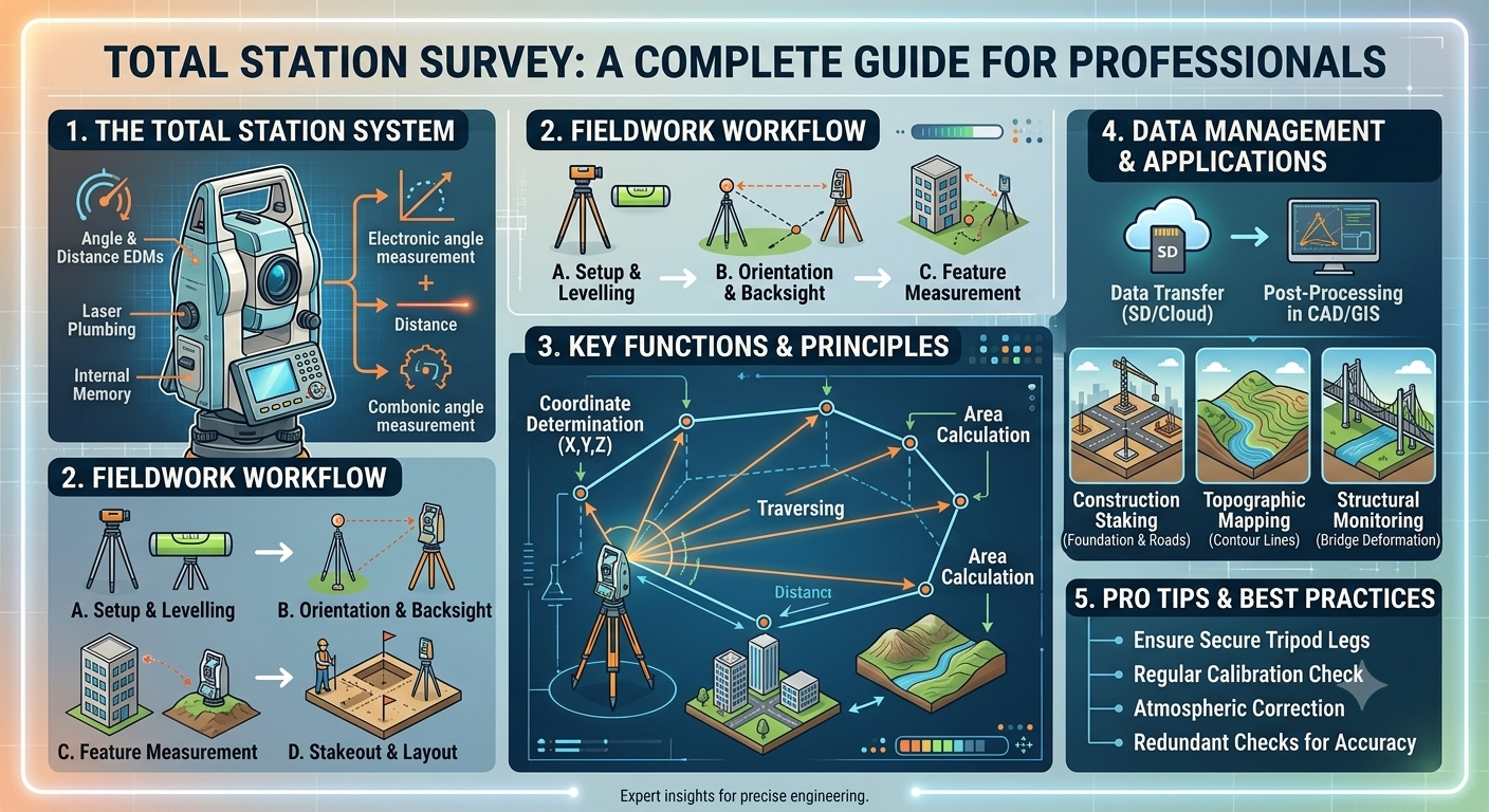
Accurate surveying is the foundation of every successful civil engineering project. Whether constructing a highway, bridge, residential building, or railway corridor, engineers depend on precise measurements to ensure that structures are built in the correct location and at the required elevation. Modern surveying technology has significantly improved accuracy and efficiency, and one of the most valuable innovations in this field is the Total Station Survey.
A total station combines electronic distance measurement, angle measurement, and digital data recording into a single instrument. This integration allows surveyors to collect highly accurate field data while reducing manual calculations and minimizing human error. Compared with conventional surveying methods, total stations increase productivity, improve precision, and simplify data transfer to design software.
This comprehensive guide explains the principles, components, working procedure, advantages, and practical applications of a Total Station Survey. Whether you are a civil engineering student, a site engineer, a contractor, or a professional surveyor, understanding this technology will help you execute projects more efficiently and accurately.
What Is a Total Station Survey?
A Total Station Survey is a modern surveying method that uses an electronic instrument known as a total station to measure horizontal angles, vertical angles, distances, and coordinates with exceptional accuracy. The collected information is stored digitally and can be transferred directly to computer-aided design (CAD), Building Information Modeling (BIM), or Geographic Information System (GIS) software for further processing.
Unlike traditional surveying methods that require separate instruments for angle and distance measurement, a total station integrates these functions into one device. This reduces fieldwork time, improves measurement consistency, and minimizes calculation errors.
Modern total stations are widely used in:
- Highway engineering
- Railway projects
- Bridge construction
- Building layout
- Topographic surveys
- Land development
- Mining operations
- Tunnel construction
- Utility mapping
Definition of a Total Station Survey
A Total Station Survey is the process of determining the position, elevation, and coordinates of points on the Earth’s surface using an electronic surveying instrument that combines angle measurement, electronic distance measurement, onboard computing, and digital data recording.
Why Total Station Surveys Are Important
Every construction project relies on accurate survey data. Even a minor measurement error can lead to costly rework, alignment issues, or structural problems.
A total station helps engineers achieve:
- High measurement precision
- Faster data collection
- Reduced human error
- Efficient project planning
- Accurate construction layout
- Better quality control
For example, when setting out bridge piers, engineers must position each foundation precisely according to the approved drawings. A total station enables this level of accuracy within millimeters, ensuring the bridge components align correctly during construction.
Components of a Total Station
A total station consists of several integrated components that work together to collect and process survey data.
Electronic Theodolite
The electronic theodolite measures horizontal and vertical angles with high precision. Digital sensors replace traditional vernier scales, allowing angles to be displayed instantly on the screen.
Primary Functions:
- Horizontal angle measurement
- Vertical angle measurement
- Alignment verification
- Direction control
Electronic Distance Measurement (EDM)
The EDM unit measures distances by transmitting electromagnetic waves or laser beams toward a prism or target. The instrument calculates the distance by analyzing the reflected signal.
Advantages of EDM:
- Rapid distance measurement
- High accuracy
- Long measurement range
- Minimal manual calculations
Modern reflectorless total stations can measure distances without a prism for many applications, making surveys more efficient in inaccessible areas.
Microprocessor
The built-in microprocessor performs real-time calculations using measured angles and distances.
It automatically computes:
- Coordinates
- Elevations
- Horizontal distances
- Vertical distances
- Area calculations
- Stakeout information
This eliminates the need for lengthy manual computations in the field.
Data Storage System
Survey data is stored electronically in the instrument’s memory.
Typical information includes:
- Point numbers
- Coordinates
- Elevations
- Feature codes
- Observation records
Digital storage simplifies data transfer to engineering software and reduces the risk of transcription errors.
Display and Keyboard
The digital display provides immediate access to survey measurements, menus, and project information. The keypad allows surveyors to input project details, select survey functions, and review collected data.
Modern touch-screen interfaces further improve usability and field efficiency.
Battery and Tripod
Rechargeable batteries provide power for extended field operations, while a sturdy tripod ensures instrument stability during observations.
A stable setup is essential for maintaining measurement accuracy, particularly during long-distance observations.
Working Principle of a Total Station Survey
A total station operates by combining angle measurements with electronic distance measurements to determine the exact coordinates of surveyed points.
The basic process includes:
- Setting up the instrument over a known control point.
- Leveling and centering the instrument.
- Orienting the instrument using a known reference point.
- Measuring horizontal and vertical angles.
- Measuring the distance to the target.
- Calculating coordinates automatically using onboard software.
- Recording the data digitally for later processing.
The resulting coordinate data can be imported directly into design and mapping software, reducing office processing time and improving project accuracy.
Types of Total Stations
Different surveying projects require different types of total stations. The selection depends on project size, required accuracy, terrain, and budget.
Manual Total Station
A manual total station requires the operator to manually aim the telescope at the survey prism.
Suitable for:
- Small construction projects
- Educational purposes
- Routine engineering surveys
Robotic Total Station
Robotic total stations automatically track the prism, allowing a single operator to perform surveys efficiently.
Advantages:
- Increased productivity
- Reduced labor requirements
- Improved measurement consistency
- Faster field operations
These instruments are widely used in large infrastructure and highway projects.
Reflectorless Total Station
Reflectorless models measure distances without using a prism.
They are particularly useful for surveying:
- Building facades
- Cliffs
- Power lines
- Dangerous slopes
- Restricted-access areas
This capability enhances safety while reducing survey time.
Advantages of a Total Station Survey
The widespread adoption of total stations is due to the significant benefits they provide over conventional surveying equipment.
Key advantages include:
- Exceptional measurement accuracy
- Faster fieldwork
- Digital data recording
- Reduced manual calculations
- Improved construction layout
- Integration with CAD and GIS software
- Efficient topographic mapping
- Simplified stakeout procedures
- Better quality control
- Lower long-term surveying costs
These advantages make total stations indispensable for modern civil engineering projects.
Step-by-Step Total Station Survey Procedure
Following a systematic workflow ensures reliable and repeatable survey results.
Step 1: Reconnaissance
Before starting fieldwork, surveyors inspect the site to identify control points, obstacles, visibility conditions, and potential hazards.
Proper planning reduces delays during data collection.
Step 2: Instrument Setup
The tripod is positioned over the selected control point, and the total station is securely mounted.
The tripod legs should be firmly embedded in the ground to prevent movement.
Step 3: Leveling and Centering
Using the optical or laser plummet, the instrument is centered precisely over the control point.
Electronic or circular bubble levels are then used to achieve perfect leveling.
Accurate centering is essential because even small setup errors can affect the entire survey.
Step 4: Orientation
The instrument is oriented by sighting a known reference point or backsight.
This establishes the survey’s coordinate system and ensures that subsequent measurements are correctly aligned.
Step 5: Data Collection
Surveyors measure each required point by aiming the telescope at the prism or target.
The instrument automatically records:
- Horizontal angle
- Vertical angle
- Slope distance
- Coordinates
- Elevation
- Feature code
Step 6: Data Verification
Before leaving the site, surveyors review the collected data to identify missing observations, incorrect point codes, or measurement inconsistencies.
Verifying data in the field helps avoid costly repeat surveys.
Practical Engineering Example
Imagine a contractor preparing to construct a four-lane highway. Before excavation begins, engineers use a total station to establish the road centerline, locate culverts, mark bridge foundations, and set pavement edges according to the approved design drawings.
The collected coordinates are transferred directly to CAD software, where engineers verify the layout and make any necessary adjustments before construction starts. This process minimizes alignment errors, improves construction accuracy, and saves both time and resources.
Simple Survey Diagram
                Prism
                  ▲
                  │
                  │
         Measured Distance
                  │
                  │
       -------------------------
             Total Station
                  ▲
                  │
          Known Control Point
The total station measures the horizontal angle, vertical angle, and slope distance to the prism. Its onboard computer then calculates the precise coordinates and elevation of the surveyed point.
Applications of Total Station Survey
A Total Station Survey is one of the most versatile surveying techniques used in civil engineering and infrastructure development. Its ability to measure angles, distances, and coordinates with exceptional precision makes it suitable for projects of every scale, from small residential buildings to large transportation networks.
Highway Engineering
Highway engineers use total stations throughout the project lifecycle. During the planning stage, they establish control points and prepare topographic maps. During construction, the instrument is used to stake out road centerlines, pavement edges, culverts, retaining walls, and bridge approaches.
Building Construction
Construction teams rely on total stations to transfer architectural drawings accurately onto the ground. Building corners, column locations, foundation lines, and floor elevations are set out with high precision, ensuring that the completed structure matches the approved design.
Bridge Construction
Bridge projects demand extremely accurate positioning because even minor alignment errors can affect structural performance. Engineers use total stations to establish pier locations, abutments, bearings, deck alignment, and expansion joints.
Railway Projects
Railway engineers employ total stations to determine track centerlines, station layouts, platform elevations, and turnout positions. Accurate surveying contributes to smoother rail operations and improved passenger safety.
Topographic Surveying
Topographic surveys provide detailed information about ground elevations and natural or man made features. The collected data is used to create contour maps and digital terrain models that support planning and design activities.
Land Development
Developers use total station surveys for property subdivision, road layouts, utility planning, drainage systems, and site grading before construction begins.
Mining and Quarrying
Mining companies depend on total stations for pit mapping, stockpile volume calculations, excavation monitoring, and equipment positioning.
Utility Mapping
Surveyors accurately locate underground pipelines, water supply networks, electrical installations, telecommunications infrastructure, and sewer systems to support maintenance and future development.
Total Station vs. Other Surveying Instruments
Choosing the right surveying instrument depends on project requirements, required accuracy, terrain, and budget.
| Feature | Total Station | Theodolite | Automatic Level | GPS/GNSS Receiver |
|---|---|---|---|---|
| Measures Angles | Yes | Yes | No | Limited |
| Measures Distance | Yes | No | No | Yes |
| Measures Elevation | Yes | Limited | Yes | Yes |
| Digital Data Storage | Yes | No | No | Yes |
| Construction Layout | Excellent | Moderate | Limited | Good |
| Accuracy | Very High | High | High (Leveling Only) | Moderate to High |
| Productivity | High | Moderate | Moderate | High |
Although GNSS technology is becoming increasingly popular, total stations remain the preferred choice whenever millimeter-level accuracy and precise construction layout are required.
Factors Affecting the Accuracy of a Total Station Survey
The quality of survey results depends not only on the instrument but also on field conditions and surveying techniques.
Instrument Calibration
A poorly calibrated instrument may produce systematic errors. Regular calibration ensures that measured angles and distances remain within the manufacturer’s specified accuracy.
Weather Conditions
Environmental conditions can influence measurement quality.
Factors include:
- High temperatures
- Heavy rainfall
- Fog
- Dust
- Strong winds
- Atmospheric pressure variations
These conditions may affect visibility and electronic distance measurements.
Instrument Setup
Improper centering or leveling introduces errors that increase with longer observation distances. Surveyors should verify the setup before recording measurements.
Prism Alignment
When using a reflector prism, incorrect positioning can result in inaccurate coordinate calculations. The prism should remain vertical and directly face the instrument.
Human Factors
Operator experience significantly affects survey quality. Incorrect point coding, targeting mistakes, or recording errors may lead to inaccurate project data.
Line of Sight
Trees, buildings, moving vehicles, and construction equipment can obstruct observations. Survey stations should provide clear visibility between the instrument and the target.
Common Errors in Total Station Surveys
Even advanced surveying equipment cannot eliminate all sources of error. Understanding these issues helps surveyors improve accuracy.
Instrument Errors
These include:
- Collimation error
- Horizontal axis error
- Vertical circle error
- Electronic calibration issues
Routine maintenance and calibration reduce these problems.
Personal Errors
Examples include:
- Poor leveling
- Incorrect prism height
- Misidentification of survey points
- Data entry mistakes
- Inadequate instrument orientation
Careful field procedures and experienced personnel help minimize these errors.
Natural Errors
Environmental influences include:
- Heat shimmer
- Atmospheric refraction
- Earth curvature over long distances
- Wind-induced instrument movement
Survey planning should account for these conditions whenever possible.
Best Practices for Conducting a Total Station Survey
Following standardized procedures improves efficiency, safety, and data quality.
- Inspect the instrument before every survey.
- Verify calibration certificates periodically.
- Establish reliable control points.
- Level and center the instrument carefully.
- Confirm prism height before measurements.
- Double-check critical observations.
- Maintain clear field notes and digital backups.
- Protect equipment from dust, moisture, and extreme temperatures.
- Transfer field data to office software promptly.
- Validate coordinates before construction staking.
Consistent adherence to these practices reduces rework and enhances project reliability.
Practical Recommendations
Civil Engineers
- Review survey control before beginning design or construction.
- Coordinate survey activities with design teams to avoid alignment conflicts.
- Verify critical dimensions before approving construction work.
- Use total station data to monitor project progress and quality.
Contractors
- Employ trained survey personnel for layout operations.
- Protect survey control points throughout construction.
- Check instrument calibration regularly.
- Reconfirm building lines and road alignments before excavation or concrete placement.
Engineering Students
- Develop a strong understanding of coordinate systems and surveying principles.
- Practice instrument setup and leveling in the field.
- Learn how to download and process survey data using CAD or GIS software.
- Study real construction projects to understand practical surveying applications.
General Discussion of IRC, AASHTO, and ICE Practices
Professional engineering organizations emphasize accurate surveying as the foundation of successful infrastructure projects.
General guidance commonly reflected in IRC, AASHTO, and ICE publications includes:
- Establish permanent survey control before construction.
- Verify horizontal and vertical control points using recognized surveying procedures.
- Perform regular instrument calibration and maintenance.
- Maintain documented quality assurance throughout survey operations.
- Confirm critical construction layouts before structural work begins.
- Use qualified survey personnel and standardized field procedures.
- Preserve survey records for future maintenance and project verification.
These practices help improve construction accuracy, reduce disputes, and support long-term infrastructure performance.
Frequently Asked Questions (FAQs)
1. What is a Total Station Survey?
A Total Station Survey is a modern surveying method that uses an electronic instrument to measure angles, distances, elevations, and coordinates with high precision while storing data digitally.
2. What are the main components of a total station?
The primary components include an electronic theodolite, electronic distance measurement (EDM) unit, onboard microprocessor, display, keyboard, data storage system, rechargeable battery, and tripod.
3. What is the difference between a total station and a theodolite?
A theodolite measures angles only, whereas a total station measures both angles and distances, automatically calculates coordinates, and stores digital survey data.
4. Where is a Total Station Survey commonly used?
It is widely used in highway construction, bridge engineering, building layout, railway projects, land development, mining, utility mapping, and topographic surveys.
5. Can a total station work without a prism?
Yes. Reflectorless total stations can measure distances to many surfaces without requiring a prism, making them useful for inaccessible or hazardous locations.
6. How accurate is a total station?
Most modern total stations provide angular accuracy of a few seconds and distance measurement accuracy within a few millimeters, depending on the instrument model and field conditions.
7. Why is instrument calibration important?
Calibration ensures that measurements remain accurate and minimizes systematic errors that could affect construction quality and project costs.
8. What software is commonly used with total station data?
Survey data is commonly transferred to CAD, GIS, BIM, and other engineering software for mapping, design, analysis, and construction layout.
9. What are the biggest challenges during a Total Station Survey?
Common challenges include poor weather, obstructed lines of sight, improper instrument setup, unstable control points, and operator errors.
10. Is a total station better than GPS?
For high-precision construction layout and engineering surveys, a total station generally provides greater accuracy. GPS or GNSS systems are often preferred for large-area surveys and establishing broad control networks, and many projects use both technologies together.
Conclusion
A Total Station Survey has become an indispensable part of modern civil engineering because it combines speed, precision, and digital data management in a single instrument. From highway construction and bridge alignment to building layout and topographic mapping, this technology supports accurate decision-making throughout every stage of a project. By understanding the instrument’s components, working principles, survey procedures, accuracy factors, and best practices, engineers and surveyors can significantly reduce measurement errors while improving construction quality and project efficiency. Regular calibration, proper instrument setup, careful field verification, and adherence to recognized engineering standards contribute to reliable survey results. Whether you are an experienced professional, a contractor responsible for site execution, or a civil engineering student developing practical skills, mastering the Total Station Survey process is an investment that enhances technical competence and ensures the successful delivery of safe, durable, and accurately constructed infrastructure.

Kamran Malik is a passionate civil engineering writer and researcher who specializes in construction, transportation, structural engineering, and infrastructure topics. Through his articles on CivilEngineerings.com, he simplifies complex engineering concepts and shares practical insights, industry trends, and educational resources for students, professionals, and engineering enthusiasts.