
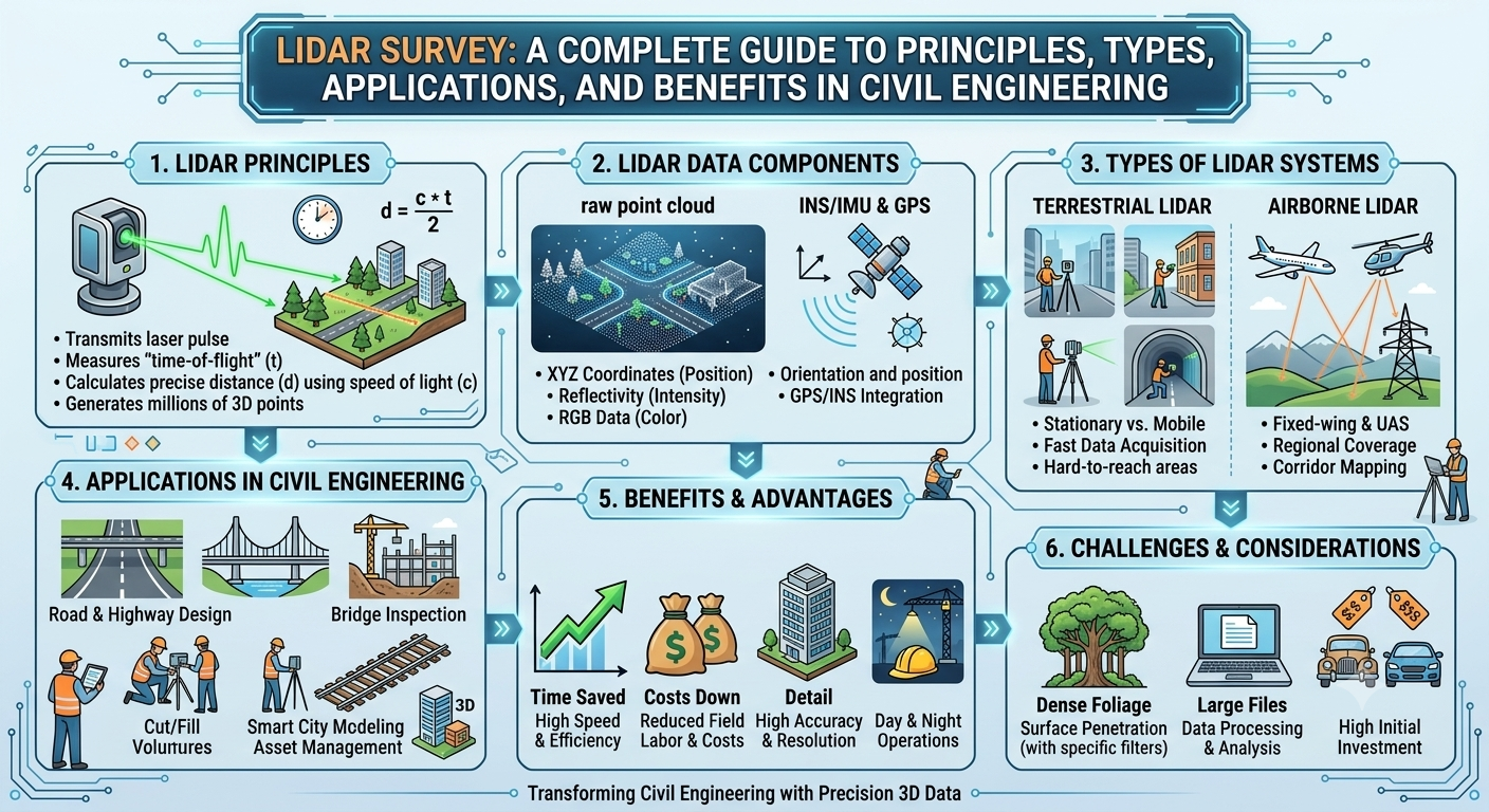
Modern civil engineering relies heavily on accurate spatial data to design safe, efficient, and sustainable infrastructure. Traditional surveying methods have served the industry for decades, but they often require significant field time and may struggle to capture complex terrain quickly. Today, LiDAR Survey technology has transformed the way engineers, surveyors, and contractors collect topographic information by providing highly detailed three-dimensional data with remarkable speed and precision.
From highway corridor planning and bridge design to flood mapping and urban development, LiDAR has become an indispensable surveying tool. By using laser pulses to measure distances between a sensor and the Earth’s surface, engineers can generate highly accurate digital terrain models, contour maps, and point clouds that support informed engineering decisions.
Whether you are a civil engineering student, surveyor, road engineer, GIS professional, or contractor, understanding the principles and applications of a LiDAR Survey is essential in today’s infrastructure industry. This guide explains how LiDAR works, explores its major types, highlights its engineering advantages, and discusses its practical applications in road and highway projects.
What Is a LiDAR Survey?
A LiDAR Survey (Light Detection and Ranging Survey) is an advanced remote sensing technique that uses laser light to measure distances between a sensor and surrounding objects. By emitting thousands—or even millions—of laser pulses every second and recording the time each pulse takes to return, the system generates an accurate three-dimensional representation of the surveyed area.
Unlike conventional surveying methods that rely on manual measurements at selected points, LiDAR captures millions of data points across the landscape. These points form a point cloud, which can be processed into digital elevation models (DEMs), digital terrain models (DTMs), contour maps, and 3D surface models.
Because of its speed and precision, LiDAR is widely used in civil engineering, transportation planning, construction, mining, forestry, disaster management, and environmental monitoring.
Key Characteristics of LiDAR Survey
- High measurement accuracy
- Rapid data acquisition
- Three-dimensional mapping
- Dense point cloud generation
- Ability to survey large areas efficiently
- Integration with GIS and CAD software
Why LiDAR Survey Is Important in Civil Engineering
Infrastructure projects demand reliable spatial information from the earliest planning stages through construction and maintenance. A LiDAR Survey provides engineers with detailed terrain data that supports better decision-making and reduces the likelihood of costly design errors.
Benefits for Civil Engineering Projects
- Improves topographic mapping accuracy
- Reduces field survey time
- Enhances design precision
- Supports corridor and route planning
- Identifies terrain irregularities
- Simplifies earthwork calculations
- Assists in drainage analysis
- Enables digital terrain modeling
For road and highway projects, LiDAR data helps engineers optimize alignments, estimate cut-and-fill volumes, identify drainage paths, and design safer transportation corridors.
How a LiDAR Survey Works
Although LiDAR systems are technologically advanced, their operating principle is straightforward. The system measures distance by calculating how long a laser pulse takes to travel to an object and return to the sensor.
1. Laser Pulse Emission
The LiDAR sensor emits rapid laser pulses toward the ground or surrounding objects. Modern systems can transmit hundreds of thousands to several million pulses every second, allowing extensive areas to be scanned efficiently.
2. Distance Measurement
When a laser pulse strikes a surface, part of the energy reflects back to the sensor. The system records the travel time and calculates the distance using the speed of light.
The basic principle is:
Distance = (Speed of Light × Travel Time) ÷ 2
Dividing by two accounts for the pulse traveling to the target and returning to the sensor.
3. Positioning and Navigation
To determine the exact location of each measurement, LiDAR systems integrate:
- Global Navigation Satellite System (GNSS)
- Inertial Measurement Unit (IMU)
- Onboard positioning software
This combination ensures that every recorded point has accurate coordinates and elevation.
4. Data Processing
After field data collection, specialized software processes the point cloud by:
- Removing noise
- Classifying ground and non-ground points
- Creating terrain models
- Generating contour maps
- Producing 3D visualizations
- Exporting data for CAD and GIS applications
The processed information becomes a valuable resource for planning, design, and construction.
Main Components of a LiDAR Survey System
A complete LiDAR system consists of several integrated components working together to capture and process spatial data.
1. Laser Scanner
The laser scanner emits pulses and records reflected signals from surrounding surfaces.
2. GNSS Receiver
The GNSS receiver determines the precise position of the survey platform during data collection.
3. Inertial Measurement Unit (IMU)
The IMU measures the orientation and movement of the platform, helping maintain positional accuracy even when the vehicle or aircraft changes direction.
4. Data Recorder
This unit stores laser returns, positional information, timestamps, and sensor data for later processing.
5. Processing Software
Specialized software converts raw measurements into engineering deliverables such as:
- Digital Terrain Models (DTMs)
- Digital Elevation Models (DEMs)
- Point clouds
- Contour maps
- Cross-sections
- 3D models
Types of LiDAR Survey
Different project requirements call for different LiDAR platforms. The choice depends on survey area, accessibility, required accuracy, and project budget.
Airborne LiDAR Survey
Airborne LiDAR systems are mounted on helicopters or fixed-wing aircraft to survey large regions quickly.
Typical Applications
- Highway corridor planning
- Floodplain mapping
- Watershed analysis
- Forest inventory
- Regional topographic surveys
Advantages
- Covers extensive areas rapidly
- Suitable for inaccessible terrain
- Efficient for regional mapping
- Produces consistent elevation data
Terrestrial LiDAR Survey
Terrestrial LiDAR systems are installed on tripods and used from fixed ground locations.
Common Uses
- Bridge inspections
- Tunnel surveys
- Building documentation
- Rock slope analysis
- Structural deformation monitoring
Advantages
- Very high accuracy
- Dense point cloud generation
- Excellent detail for engineering structures
Mobile LiDAR Survey
Mobile LiDAR systems are mounted on moving vehicles, enabling rapid data collection along transportation corridors.
Common Applications
- Highway inventory
- Road asset management
- Pavement condition surveys
- Utility mapping
- Railway corridor surveys
Advantages
- Minimal traffic disruption
- Fast corridor mapping
- High productivity
- Accurate roadside feature capture
Drone LiDAR Survey
Unmanned Aerial Vehicles (UAVs) equipped with LiDAR sensors have become increasingly popular for medium-sized projects.
Applications
- Construction monitoring
- Quarry surveys
- Earthwork measurements
- Transmission line inspections
- Small highway projects
Advantages
- Flexible deployment
- Lower operational cost
- Access to difficult terrain
- Frequent progress monitoring
Engineering Diagram: LiDAR Data Collection Process
                 GNSS Satellite
                       │
                       ▼
              +----------------+
              | GNSS Receiver  |
              +----------------+
                       │
                       ▼
            +---------------------+
            | LiDAR Sensor & IMU  |
            +---------------------+
                       │
          Laser Pulses ▼▼▼▼▼▼▼▼▼
        ───────────────────────────
             Ground / Road Surface
        ▲ ▲ ▲ ▲ ▲ ▲ ▲ ▲ ▲ ▲ ▲ ▲
        Reflected Laser Pulses
                       │
                       ▼
              Point Cloud Data
                       │
                       ▼
      Digital Terrain Model (DTM)
                       │
                       ▼
     CAD, GIS & Highway Design
This workflow illustrates how positional data, laser measurements, and processing software combine to create accurate digital terrain information for engineering projects.
Advantages of LiDAR Survey
Compared with conventional surveying methods, LiDAR offers significant technical and operational advantages.
Major Benefits
- Rapid data acquisition over large areas
- High positional accuracy
- Detailed three-dimensional mapping
- Reduced fieldwork duration
- Improved worker safety in hazardous environments
- Efficient earthwork volume calculations
- Reliable data for BIM, GIS, and CAD integration
- Ability to survey densely vegetated or inaccessible areas
- Enhanced project planning and design quality
- Reduced overall project costs through improved decision-making
These advantages make LiDAR one of the most effective technologies for modern infrastructure development.
Applications of LiDAR Survey in Road Engineering
LiDAR has become a standard tool in transportation engineering because it provides detailed terrain information with exceptional efficiency.
Highway Planning
Engineers use LiDAR to identify suitable corridors, analyze terrain, and evaluate alternative alignments before detailed design begins.
Topographic Mapping
Accurate topographic maps generated from LiDAR support geometric design, drainage planning, and earthwork estimation.
Earthwork Calculations
Point cloud data allows engineers to estimate cut-and-fill volumes with greater accuracy, improving cost estimates and construction planning.
Bridge and Culvert Design
LiDAR data helps define existing ground conditions, watercourses, and structural locations for bridge and culvert projects.
Construction Monitoring
Periodic LiDAR surveys enable project teams to compare actual site progress with design models, ensuring quality and schedule compliance.
Asset Management
Transportation agencies use mobile LiDAR to inventory road signs, guardrails, lighting poles, barriers, and pavement markings, creating comprehensive digital asset databases.
Key Takeaways
A LiDAR Survey has transformed modern civil and road engineering by providing fast, highly accurate, and detailed three-dimensional spatial data. Through laser scanning, GNSS positioning, and advanced processing software, LiDAR enables engineers to develop reliable terrain models that support highway planning, construction, and infrastructure management. Understanding the different types of LiDAR systems and their practical applications allows engineers, contractors, and students to select the most suitable technology for each project, ultimately improving efficiency, safety, and design accuracy.
LiDAR Survey Workflow: Step-by-Step Process
A successful LiDAR Survey follows a structured workflow that ensures the collected data is accurate, reliable, and suitable for engineering design. Although the procedure may vary depending on the project size and survey platform, the fundamental stages remain the same.
Step 1: Project Planning
Every LiDAR project begins with defining clear objectives. Engineers determine the required survey accuracy, project boundaries, terrain conditions, deliverables, and the most suitable LiDAR platform.
During this phase, the survey team also reviews:
- Existing maps and drawings
- Satellite imagery
- Airspace restrictions (for UAV or airborne surveys)
- Weather forecasts
- Site accessibility
- Safety requirements
Proper planning minimizes field delays and ensures efficient data collection.
Step 2: Ground Control Survey
Ground Control Points (GCPs) are established using high-precision GNSS or total stations. These reference points improve positional accuracy and validate the final LiDAR dataset.
Well-distributed control points help reduce systematic errors and increase confidence in engineering measurements.
Step 3: Data Acquisition
The LiDAR sensor is mounted on an aircraft, drone, vehicle, or tripod, depending on project requirements.
During operation, the system continuously records:
- Laser returns
- GPS coordinates
- IMU data
- Time stamps
- Sensor orientation
Modern LiDAR systems can capture millions of measurements within a short period, making them highly efficient for large-scale infrastructure projects.
Step 4: Point Cloud Processing
Raw point cloud data contains millions of points that require processing before engineering use.
Specialized software performs tasks such as:
- Noise removal
- Point classification
- Coordinate correction
- Ground surface extraction
- Vegetation filtering
- Building identification
The processed dataset forms the foundation for digital terrain modeling.
Step 5: Model Generation
After classification, engineers create project deliverables such as:
- Digital Terrain Models (DTMs)
- Digital Elevation Models (DEMs)
- Contour maps
- Cross-sections
- Longitudinal profiles
- Three-dimensional surface models
These outputs support planning, design, construction, and maintenance activities.
Step 6: Quality Assurance
Before final delivery, engineers verify:
- Horizontal accuracy
- Vertical accuracy
- Point density
- Coverage completeness
- Coordinate consistency
- Data classification
Independent quality checks ensure the survey meets project specifications.
LiDAR Survey Workflow Diagram
Project Planning
        │
        ▼
Ground Control Survey
        │
        ▼
LiDAR Data Collection
        │
        ▼
Point Cloud Processing
        │
        ▼
Terrain & Surface Models
        │
        ▼
Quality Verification
        │
        ▼
Engineering Design & GIS Applications
Engineering Principles Behind LiDAR Survey
LiDAR technology is based on well-established engineering and scientific principles that enable highly accurate spatial measurements.
Time of Flight Principle
The system calculates the distance between the sensor and an object by measuring the travel time of each laser pulse.
Since the speed of light is constant, very small time differences can be converted into precise distance measurements.
Multiple Return Principle
A single laser pulse may strike several surfaces before reaching the ground.
For example:
- First Return → Tree canopy
- Second Return → Branches
- Final Return → Ground surface
This capability allows engineers to generate terrain models even in densely vegetated areas.
Point Cloud Generation
Each reflected pulse becomes an individual point with:
- X coordinate
- Y coordinate
- Elevation (Z)
- Reflection intensity
Millions of these points create an accurate three-dimensional representation of the surveyed area.
Integration with GNSS and IMU
LiDAR alone measures distance.
Accurate positioning is achieved by combining:
- Global Navigation Satellite Systems (GNSS)
- Inertial Measurement Units (IMU)
This integration enables the precise georeferencing required for engineering applications.
Factors Affecting LiDAR Survey Accuracy
Although LiDAR provides exceptional precision, several factors influence the quality of the collected data.
Sensor Quality
High-performance sensors generally produce denser point clouds and improved measurement accuracy.
Flight or Vehicle Speed
Excessive speed can reduce point density, affecting the level of detail in the final dataset.
Flying Height
Higher flight altitudes increase coverage but may reduce point density and vertical accuracy.
Weather Conditions
Rain, heavy fog, dust, and snow can interfere with laser pulses and degrade data quality.
Calm, dry weather generally provides the best survey conditions.
Vegetation Density
Dense forests reduce the number of laser pulses reaching the ground.
However, modern LiDAR systems often capture multiple returns, allowing many ground points to be extracted even beneath vegetation.
Ground Control Quality
Accurate Ground Control Points are essential for validating and improving positional accuracy.
Poorly distributed control points may introduce systematic errors into the final model.
Limitations of LiDAR Survey
Despite its many advantages, LiDAR is not suitable for every situation.
Some limitations include:
- Higher initial equipment costs
- Large data storage requirements
- Specialized processing software
- Skilled personnel required
- Reduced performance during adverse weather
- Limited penetration through water surfaces
- Complex point cloud processing
Understanding these limitations helps engineers select the most appropriate surveying method for each project.
Best Practices for LiDAR Survey
The following practices improve data quality and project efficiency.
- Clearly define project objectives before fieldwork.
- Select the appropriate LiDAR platform for the site.
- Establish accurate Ground Control Points.
- Perform regular equipment calibration.
- Schedule surveys during favorable weather.
- Validate data through independent quality checks.
- Use experienced personnel for processing and interpretation.
- Maintain consistent coordinate systems across all datasets.
- Archive raw and processed data securely.
- Integrate LiDAR outputs with GIS, BIM, and CAD workflows.
Practical Recommendations
Civil Engineers
- Use LiDAR during the preliminary planning stage to reduce design uncertainties.
- Verify LiDAR outputs with selective field surveys for critical structures.
- Combine LiDAR data with geotechnical investigations for comprehensive site analysis.
- Incorporate LiDAR-derived terrain models into drainage and earthwork design.
Contractors
- Employ drone LiDAR for monitoring construction progress.
- Compare field conditions with design models regularly.
- Use LiDAR for calculating excavation and embankment volumes.
- Maintain accurate digital records for project documentation.
Engineering Students
- Learn the fundamentals of point cloud processing.
- Develop proficiency in GIS and CAD software.
- Understand GNSS and IMU integration.
- Explore LiDAR applications in transportation, structural, and environmental engineering.
General Discussion of IRC, AASHTO, and ICE Practices
Leading engineering organizations recognize the growing role of advanced surveying technologies in infrastructure projects.
General guidance commonly emphasizes:
- Collecting accurate topographic information before detailed design.
- Integrating geospatial data into highway planning.
- Performing quality assurance throughout the survey process.
- Maintaining consistent coordinate reference systems.
- Combining remote sensing with conventional field verification where necessary.
- Using reliable terrain information for pavement, drainage, and structural design.
- Following documented survey procedures and quality management practices.
Although project-specific requirements differ, these principles support safe, efficient, and high-quality infrastructure development.
Frequently Asked Questions (FAQs)
1. What does LiDAR stand for?
LiDAR stands for Light Detection and Ranging, a remote sensing technology that measures distances using laser pulses.
2. How accurate is a LiDAR Survey?
Depending on the equipment, survey method, and project conditions, LiDAR surveys can achieve centimeter-level horizontal and vertical accuracy.
3. Is LiDAR better than traditional surveying?
LiDAR is faster and captures significantly more data than conventional methods, making it ideal for large or complex projects. Traditional surveys may still be required for specific control points and detailed engineering verification.
4. Where is LiDAR commonly used?
LiDAR is widely applied in highway engineering, railway projects, bridge design, mining, forestry, flood mapping, utility management, and urban planning.
5. Can LiDAR work at night?
Yes. Because LiDAR uses its own laser source rather than sunlight, it can operate effectively during both day and night.
6. Does LiDAR penetrate vegetation?
Many LiDAR systems record multiple returns, enabling engineers to identify ground surfaces beneath vegetation and create accurate terrain models.
7. What software is used to process LiDAR data?
Point cloud processing and analysis are commonly performed using specialized geospatial and CAD software capable of generating terrain models, contours, and engineering drawings.
8. Is LiDAR suitable for road construction projects?
Yes. LiDAR is extensively used for route selection, topographic mapping, earthwork estimation, drainage analysis, construction monitoring, and infrastructure asset management.
9. What is a point cloud?
A point cloud is a collection of millions of georeferenced points representing the three-dimensional shape and surface characteristics of the surveyed area.
10. Can LiDAR replace conventional surveying completely?
No. While LiDAR significantly improves efficiency and coverage, conventional surveying remains important for establishing control points, validating data, and performing high-precision engineering measurements.
Conclusion
A LiDAR Survey has revolutionized modern civil and road engineering by delivering fast, accurate, and highly detailed three-dimensional spatial data. Unlike traditional surveying methods, LiDAR can efficiently capture millions of measurements across large and complex terrains, enabling engineers to make informed decisions during planning, design, construction, and maintenance. From highway corridor selection and topographic mapping to earthwork estimation and digital asset management, its applications continue to expand as infrastructure projects become more sophisticated. By following proven survey workflows, maintaining rigorous quality assurance procedures, and integrating LiDAR data with GNSS, GIS, BIM, and CAD technologies, project teams can improve accuracy, reduce costs, and enhance project outcomes. Although field verification and conventional surveying remain important for certain tasks, LiDAR Survey technology has become an indispensable tool for engineers, contractors, and students seeking efficient, reliable, and future-ready surveying solutions that support safer and more sustainable infrastructure development.

Kamran Malik is a passionate civil engineering writer and researcher who specializes in construction, transportation, structural engineering, and infrastructure topics. Through his articles on CivilEngineerings.com, he simplifies complex engineering concepts and shares practical insights, industry trends, and educational resources for students, professionals, and engineering enthusiasts.