
Introduction
Accurate measurements form the backbone of every successful civil engineering project. Engineers rely on precise surveying techniques before they design roads, highways, bridges, railways, tunnels, dams, and buildings. Among the many surveying methods, Theodolite Survey remains one of the most reliable techniques for measuring horizontal and vertical angles with exceptional accuracy.
A theodolite allows surveyors to establish control points, determine alignments, measure elevations, and set out engineering works with confidence. Although modern total stations have become increasingly popular, theodolites continue to play an essential role in engineering education, construction projects, and precision surveys. Every civil engineer should understand how this instrument works because its operating principles form the foundation of advanced surveying technologies.
This guide explains Theodolite Survey in detail, covering its definition, history, engineering principles, components, types, and field procedures. Practical examples, engineering diagrams, and industry best practices make this guide valuable for students, surveyors, site engineers, contractors, and highway professionals.
What Is Theodolite Survey?
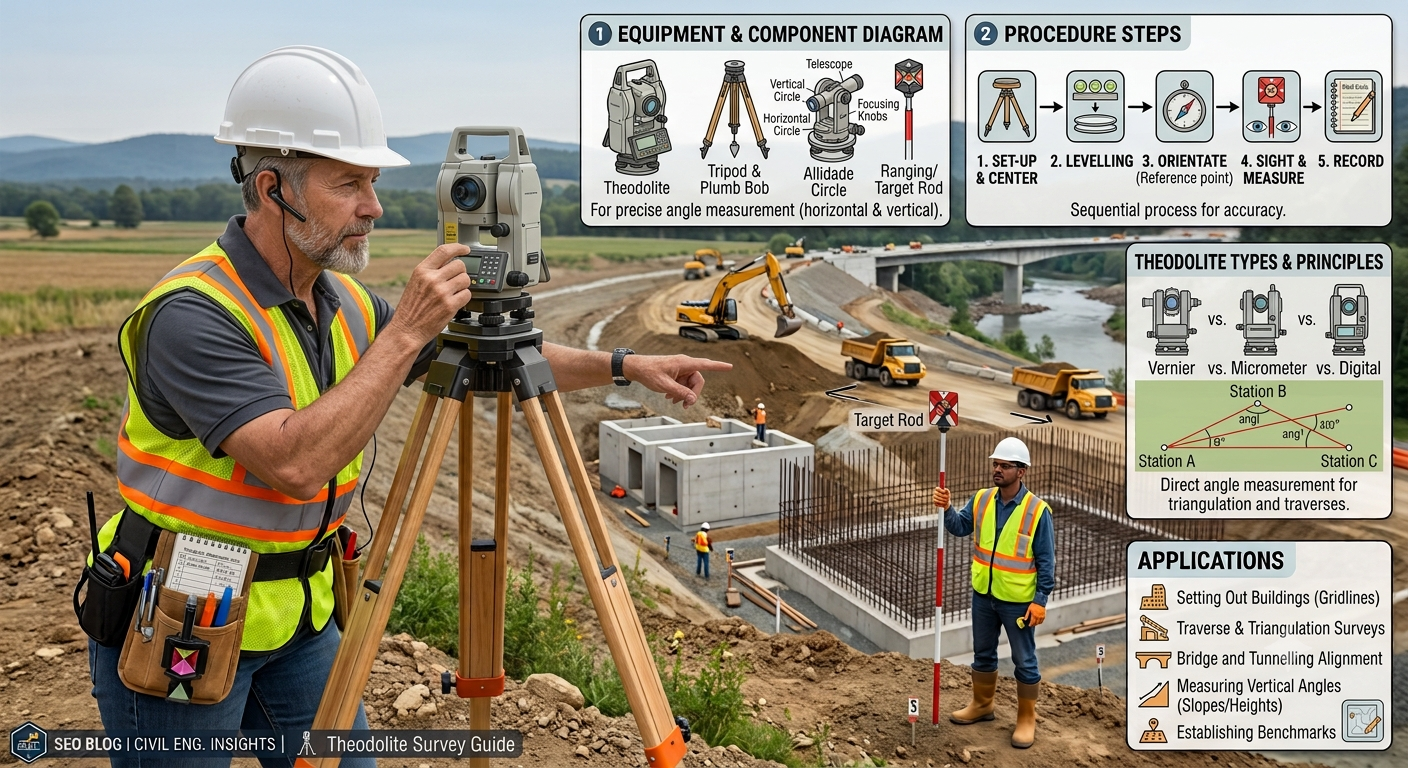
Theodolite Survey is a surveying method that uses a precision optical instrument called a theodolite to measure horizontal and vertical angles accurately. Engineers use these angle measurements to establish control points, determine alignments, locate structures, and prepare detailed maps.
Unlike simple chain surveying, theodolite surveying provides much higher precision. It allows surveyors to work on large infrastructure projects where small measurement errors can create significant construction problems.
Primary Objectives of Theodolite Survey
- Measure horizontal angles accurately.
- Measure vertical angles precisely.
- Establish survey control points.
- Set out construction layouts.
- Determine alignments.
- Calculate elevations and coordinates.
- Support topographic mapping.
History of Theodolite Surveying
Surveying instruments have evolved over centuries. Early surveyors relied on simple compasses and sighting devices, but growing engineering demands required greater accuracy.
The invention of the theodolite marked a significant advancement in land surveying. Mechanical theodolites became widely used during the eighteenth and nineteenth centuries for railway construction, canal development, military mapping, and highway projects.
Modern electronic and digital theodolites now provide faster readings, improved precision, and digital data storage. Despite these technological improvements, the fundamental principles of Theodolite Survey remain unchanged.
Importance of Theodolite Survey
Civil engineering projects demand accurate measurements before construction begins. Even a small angular error can affect road alignment, bridge positioning, or building layout.
Why Theodolite Survey Is Important
- Ensures accurate road alignments.
- Improves construction precision.
- Reduces layout errors.
- Supports large-scale infrastructure projects.
- Produces reliable topographic maps.
- Improves quality control during construction.
- Minimizes costly rework.
Highway Engineering Applications
Highway engineers frequently use theodolites for:
- Route alignment
- Horizontal curve setting
- Vertical curve layout
- Bridge positioning
- Culvert alignment
- Road centerline establishment
- Cross-section surveys
Basic Principles of Theodolite Survey
Theodolite surveying follows several fundamental engineering principles that ensure accurate and repeatable measurements.
1. Accurate Centering
The instrument must stand exactly above the survey station. Proper centering eliminates positional errors.
2. Precise Leveling
The surveyor levels the instrument so that the vertical axis remains perfectly upright. Accurate leveling ensures reliable angle measurements.
3. Clear Line of Sight
The telescope must focus sharply on the target. A clear sightline reduces observational errors.
4. Stable Instrument Setup
A firmly planted tripod prevents movement during observations. Even slight vibrations can affect measurement accuracy.
5. Repeated Observations
Surveyors often repeat measurements from different positions to verify results and improve precision.
Main Components of a Theodolite
Understanding each component helps engineers operate the instrument correctly and maintain measurement accuracy.
Telescope
The telescope allows the surveyor to observe distant targets accurately. It rotates in both horizontal and vertical planes.
Vertical Circle
The vertical circle measures vertical angles above or below the horizontal plane.
Horizontal Circle
The horizontal circle measures horizontal angles between survey lines.
Level Tubes
Bubble levels help the surveyor level the instrument before taking measurements.
Tripod
The tripod provides a stable platform for the theodolite.
Foot Screws
Surveyors use the foot screws to level the instrument precisely.
Clamp and Tangent Screws
These screws allow coarse and fine adjustments while pointing at targets.
Types of Theodolites
Different surveying projects require different types of instruments.
1. Transit Theodolite
The telescope rotates through 180 degrees in the vertical plane.
Features
- Most commonly used
- High accuracy
- Suitable for engineering surveys
- Easy to operate
2. Non-Transit Theodolite
The telescope cannot complete a full vertical rotation.
Applications
- Older surveying systems
- Limited engineering work
3. Optical Theodolite
This traditional instrument uses graduated circles viewed through optical microscopes.
Advantages
- Durable
- Reliable
- No batteries required
4. Digital Theodolite
A digital display shows measured angles directly, reducing reading errors and improving efficiency.
Advantages
- Faster measurements
- Better accuracy
- Easy data reading
- Reduced human error
5. Electronic Theodolite
Electronic sensors automatically measure angles and often integrate with surveying software.
Benefits
- High precision
- Digital storage
- Improved productivity
- Suitable for modern infrastructure projects
Theodolite Survey Procedure Step by Step
Step 1: Reconnaissance
The survey team first visits the site to understand the terrain, identify control points, and select suitable instrument stations.
Objectives
- Study site conditions.
- Locate reference points.
- Plan survey operations.
- Identify possible obstacles.
Step 2: Instrument Setup
The surveyor places the tripod over the selected station and mounts the theodolite securely.
Best Practices
- Spread tripod legs evenly.
- Keep the tripod stable.
- Position the instrument at a comfortable height.
Step 3: Centering
Centering places the vertical axis of the theodolite exactly above the survey station.
Surveyors usually perform centering with:
- Plumb bob
- Optical plummet
- Laser plummet
Accurate centering directly improves survey precision.
Step 4: Leveling
The surveyor adjusts the foot screws until the bubble remains centered in every direction.
Proper leveling ensures that both horizontal and vertical angle measurements remain accurate.
Step 5: Focusing
The telescope receives careful focusing in two stages.
Eyepiece Adjustment
The surveyor sharpens the crosshairs.
Objective Lens Adjustment
The surveyor focuses on the target until the image appears clear and free from parallax.
Step 6: Measuring Horizontal Angles
The surveyor sights the first target and records the initial reading. The telescope then rotates toward the second target, and the difference between the two readings provides the horizontal angle.
Practical Applications
- Road centerline layout
- Property boundary surveys
- Building setting out
- Bridge alignment
Step 7: Measuring Vertical Angles
The telescope rotates vertically to measure the angle above or below the horizontal plane.
Engineers use these measurements for:
- Slope calculations
- Height determination
- Earthwork estimation
- Gradient design
- Highway profile surveys
Practical Engineering Example
A highway engineer needs to establish the centerline for a new bypass road. After installing the theodolite at a control point, the surveyor measures horizontal angles to several reference stations. The recorded angles help define the exact alignment of the proposed highway. Vertical angle observations then determine ground slopes, allowing designers to develop safe gradients and minimize earthwork costs. This systematic process ensures that the final alignment satisfies both engineering standards and site conditions.
Field Diagram of a Theodolite Survey
Basic Instrument Setup
                 Target B
                    ●
                   /
                  /
                 /
                /
      Telescope
          │
     ┌─────────┐
     │Theodolite│
     └─────────┘
          │
       Tripod
      /   │   \
     /    │    \
    /     │     \
 Survey Station
Measuring Horizontal Angle
          Target A
              ●
               \
                \
                 \
                  O  Instrument Station
                 /
                /
               /
              ●
         Target B

Horizontal Angle = ∠AOB
Measuring Vertical Angle
          Target
             ●
            /
           /
          /
         /
        O──────────── Horizontal Line
         \
          \
           Ground
Sources of Errors in Theodolite Survey
Even the most advanced surveying instruments can produce inaccurate results if surveyors ignore proper field procedures. A successful Theodolite Survey depends on careful instrument handling, favorable site conditions, and consistent observation techniques.
Understanding common errors helps engineers improve accuracy and reduce costly mistakes during construction.
1. Instrumental Errors
Instrumental errors arise from defects or improper adjustments within the theodolite itself.
Common causes include:
- Misaligned telescope
- Worn clamp screws
- Improperly calibrated circles
- Damaged bubble tubes
- Loose tripod connections
Prevention
- Calibrate the instrument regularly.
- Inspect components before every survey.
- Replace worn or damaged parts promptly.
2. Personal Errors
Personal errors result from mistakes made by the surveyor during observations.
Examples include:
- Improper centering
- Incorrect leveling
- Poor focusing
- Misreading angle scales
- Recording incorrect values
Prevention
- Follow a consistent surveying procedure.
- Repeat observations.
- Verify field notes before leaving the site.
3. Natural Errors
Environmental conditions can also influence measurement accuracy.
Typical natural factors
- Strong winds
- Temperature variations
- Heat waves
- Poor visibility
- Atmospheric refraction
Prevention
- Conduct surveys during stable weather.
- Avoid observations during extreme heat.
- Maintain a clear line of sight.
Methods to Minimize Survey Errors
Professional surveyors rely on proven techniques to improve precision and consistency.
Best Practices
- Center the instrument accurately over the survey station.
- Level the theodolite carefully before every observation.
- Check bubble levels frequently.
- Focus the telescope to eliminate parallax.
- Observe each angle at least twice.
- Compare readings from different faces of the instrument.
- Keep the tripod firmly anchored.
- Protect the instrument from unnecessary vibration.
Following these practices significantly improves the quality of survey results.
Applications of Theodolite Survey in Civil Engineering
The versatility of Theodolite Survey makes it valuable across many civil engineering disciplines.
Highway Engineering
Highway engineers frequently use theodolites for:
- Route alignment
- Horizontal curve setting
- Vertical curve layout
- Road centerline establishment
- Cross-section surveys
- Earthwork calculations
- Bridge approach alignment
Accurate angular measurements ensure safe road geometry and smooth traffic flow.
Railway Engineering
Surveyors establish railway centerlines, curves, gradients, and station locations with high precision.
Bridge Construction
Bridge engineers use theodolites to:
- Align bridge piers
- Position abutments
- Check structural alignment
- Monitor construction accuracy
Building Construction
Building projects require theodolites for:
- Foundation layout
- Column positioning
- Wall alignment
- Verticality checks
- Structural control
Tunnel Engineering
Surveyors maintain precise tunnel alignment from both ends to ensure successful breakthrough during excavation.
Dam Construction
Theodolites assist engineers in:
- Dam axis layout
- Spillway alignment
- Monitoring structural movement
- Construction control surveys
Mining Projects
Mining engineers use theodolites to establish excavation lines, underground alignments, and exploration boundaries.
Advantages of Theodolite Survey
Theodolite surveying remains an essential technique because it offers numerous engineering benefits.
Major Advantages
- High measurement accuracy
- Reliable horizontal angle measurement
- Precise vertical angle determination
- Suitable for large infrastructure projects
- Durable field equipment
- Supports topographic mapping
- Improves construction quality
- Reduces layout errors
- Compatible with modern surveying methods
- Provides dependable control for engineering works
Limitations of Theodolite Survey
Although highly accurate, theodolite surveying has certain limitations.
Common Limitations
- Requires skilled operators.
- Field setup consumes time.
- Poor weather affects observations.
- Dense vegetation blocks sight lines.
- Manual observations increase human error.
- Large projects often benefit from total stations or GNSS technology.
Despite these limitations, theodolites remain valuable for precision engineering and educational training.
Engineering Best Practices
Experienced surveyors consistently apply practical field techniques to improve accuracy and efficiency.
Planning
- Review project drawings before fieldwork.
- Identify permanent control points.
- Plan observation sequences.
Instrument Care
- Store the instrument in a protective case.
- Clean lenses regularly.
- Avoid sudden impacts.
- Check calibration before important surveys.
Field Operations
- Use stable tripod placement.
- Record observations immediately.
- Verify measurements with repeat observations.
- Maintain clear communication among the survey team.
Documentation
- Keep organized field notes.
- Record weather conditions.
- Document control station coordinates.
- Archive survey data securely.
Practical Recommendations
Civil Engineers
- Verify survey control before beginning construction.
- Coordinate surveying activities with the design team.
- Confirm alignment before earthwork starts.
- Review survey reports regularly.
Contractors
- Protect established control points throughout construction.
- Avoid disturbing survey markers with heavy equipment.
- Schedule periodic layout verification.
- Train field crews in basic survey procedures.
Engineering Students
- Practice instrument setup repeatedly.
- Learn both optical and digital theodolites.
- Understand common survey errors.
- Participate in field exercises whenever possible.
- Study surveying standards used in highway engineering.
General Discussion of IRC, AASHTO, and ICE Practices
International highway engineering organizations emphasize accurate surveying as the foundation of successful infrastructure projects.
General engineering guidance commonly recommends:
- Establish reliable survey control networks before design.
- Perform repeated observations to verify measurements.
- Maintain instrument calibration throughout the project.
- Document survey data systematically.
- Integrate surveying with geotechnical investigations and highway design.
- Verify construction layouts before major earthwork operations.
- Follow approved quality assurance procedures during all surveying activities.
These principles contribute to safer, more accurate, and more durable transportation infrastructure.
Frequently Asked Questions (FAQs)
1. What is a Theodolite Survey?
A Theodolite Survey is a surveying method that uses a theodolite to measure horizontal and vertical angles accurately for engineering, mapping, and construction projects.
2. Why is a theodolite important in highway engineering?
It helps establish road alignments, set out horizontal and vertical curves, determine centerlines, and improve construction accuracy.
3. What is the difference between a theodolite and a total station?
A theodolite measures angles only, while a total station measures angles, distances, and coordinates electronically with built-in data storage.
4. Which projects commonly use Theodolite Survey?
Roads, highways, railways, bridges, tunnels, dams, buildings, pipelines, airports, and mining projects commonly use this surveying technique.
5. How can surveyors reduce errors during a Theodolite Survey?
Proper centering, careful leveling, repeated observations, instrument calibration, accurate note-taking, and favorable weather conditions help reduce errors.
6. What skills should a surveyor develop before using a theodolite?
A surveyor should understand instrument setup, leveling, centering, focusing, angle measurement, field calculations, and survey documentation.
7. Is Theodolite Survey still relevant today?
Yes. Although total stations and GNSS equipment dominate modern surveying, theodolites remain essential for engineering education, construction layout, and precision angle measurement.
8. Which type of theodolite is best for modern projects?
Digital and electronic theodolites provide faster observations, improved accuracy, and easier data recording, making them suitable for most modern engineering projects.
9. What factors affect the accuracy of a Theodolite Survey?
Instrument calibration, operator skill, weather conditions, tripod stability, proper centering, leveling, and clear visibility all influence survey accuracy.
10. Can students learn surveying with a traditional optical theodolite?
Yes. Learning with an optical theodolite builds a strong understanding of surveying principles before progressing to digital theodolites and total stations.
Conclusion
Theodolite Survey remains one of the most reliable and precise surveying methods in civil and highway engineering. Its ability to measure horizontal and vertical angles accurately makes it indispensable for road alignment, bridge construction, railway projects, building layout, tunnel excavation, and topographic mapping. Although modern technologies such as total stations and GNSS receivers have expanded surveying capabilities, theodolites continue to provide the fundamental principles behind accurate field measurements. Engineers, contractors, and students who master instrument setup, centering, leveling, observation techniques, and error control can produce dependable survey data that supports safe and efficient infrastructure development. By following recognized engineering practices, maintaining properly calibrated equipment, and applying disciplined field procedures, professionals can maximize the accuracy and reliability of every Theodolite Survey, contributing to successful project planning, design, and construction.

Kamran Malik is a passionate civil engineering writer and researcher who specializes in construction, transportation, structural engineering, and infrastructure topics. Through his articles on CivilEngineerings.com, he simplifies complex engineering concepts and shares practical insights, industry trends, and educational resources for students, professionals, and engineering enthusiasts.