
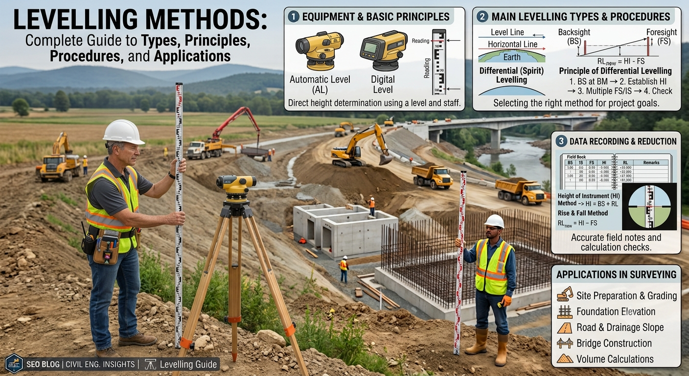
Introduction
Accurate elevation measurement forms the foundation of every successful civil engineering and road construction project. Before engineers design a highway, railway, bridge, canal, building, or drainage system, they must determine the relative heights of different points on the ground. This critical surveying activity is known as levelling, and the techniques used to perform it are called Levelling Methods.
Every road alignment, pavement profile, embankment, excavation, and drainage network depends on precise levelling data. Even a small error in elevation measurement can lead to poor drainage, uneven pavement, structural instability, or increased construction costs. For this reason, surveyors follow established levelling procedures and use calibrated instruments to achieve reliable results.
Modern surveying combines traditional spirit levelling with advanced technologies such as digital levels, laser levels, and GNSS equipment. However, the engineering principles remain the same: determine the difference in elevation accurately and efficiently.
This guide explains the most important Levelling Methods, their working principles, field procedures, engineering applications, advantages, limitations, and best practices for engineers, contractors, and students.
What Is Levelling?
Levelling is the process of determining the difference in elevation between two or more points on the Earth’s surface. Surveyors use this information to establish reference levels, prepare contour maps, design road gradients, calculate earthwork quantities, and ensure proper drainage.
In civil engineering, levelling provides the vertical control required for construction projects. Unlike horizontal surveying, which measures distances and directions, levelling focuses on height differences.
Objectives of Levelling
- Determine ground elevations.
- Establish benchmark levels.
- Design road gradients.
- Control construction levels.
- Calculate cut-and-fill quantities.
- Ensure proper drainage.
- Set foundation levels.
- Monitor settlement of structures.
Why Levelling Is Important in Civil Engineering
Levelling supports almost every stage of infrastructure development. Engineers rely on accurate elevation data to design safe, durable, and cost-effective projects.
Major Applications
Highway Engineering
Engineers use levelling to:
- Design longitudinal gradients.
- Establish road formation levels.
- Calculate embankment heights.
- Control pavement thickness.
- Plan drainage systems.
Railway Engineering
Levelling helps maintain smooth track alignment and safe operating gradients.
Building Construction
Surveyors establish foundation levels, floor elevations, and plinth heights using precise levelling techniques.
Irrigation Projects
Canals require controlled water flow. Accurate levelling ensures water reaches its destination efficiently.
Bridge Construction
Bridge abutments, piers, and deck levels depend on reliable elevation measurements.
Land Development
Developers use levelling to prepare construction sites, control earthworks, and improve surface drainage.
Basic Principles of Levelling
Every levelling method follows a simple engineering principle.
A horizontal line of sight created by a levelling instrument serves as the reference plane. Surveyors measure vertical distances from this line to determine elevation differences.
Key Terms
Benchmark (BM)
A benchmark is a permanent reference point with a known elevation.
Back Sight (BS)
The first staff reading taken after setting up the level.
Intermediate Sight (IS)
A reading taken on any point between the back sight and the fore sight.
Fore Sight (FS)
The final staff reading before shifting the instrument.
Reduced Level (RL)
The elevation of a point relative to a chosen datum.
Height of Instrument (HI)
The elevation of the line of sight above the reference datum.
Simple Levelling Diagram
                 Line of Sight
------------------------------------------------

        Level Instrument
             ▲
             │
      ───────────────

Staff A                     Staff B
  │                            │
  │                            │
  │                            │
Ground A ---------------------- Ground B
The level instrument establishes a horizontal line of sight. Staff readings at different points allow surveyors to calculate the difference in elevation.
Classification of Levelling Methods
Surveyors generally classify Levelling Methods into two major categories:
1. Direct (Spirit) Levelling
This method uses a levelling instrument and a levelling staff. It delivers high accuracy and remains the preferred technique for most engineering projects.
2. Indirect Levelling
Indirect methods determine elevation differences using angles, atmospheric pressure, electronic measurements, or satellite positioning. These techniques are suitable for specific field conditions and large-scale surveys.
Direct (Spirit) Levelling Methods
1. Simple Levelling
Simple levelling measures the elevation difference between two nearby points using a single instrument setup.
Procedure
- Set up the level instrument midway between the two points.
- Level the instrument carefully.
- Take a back sight reading on the first point.
- Take a fore sight reading on the second point.
- Calculate the difference in elevation.
Practical Example
A contractor needs to determine whether a concrete slab has the correct slope for drainage. Since both ends of the slab are visible from one instrument position, simple levelling provides a quick and accurate solution.
Advantages
- Fast procedure
- High accuracy
- Minimal calculations
- Suitable for short distances
Limitations
- Works only when both points remain visible from one setup.
- Not suitable for long routes.
2. Differential Levelling
Differential levelling measures elevation differences between points that lie far apart or cannot be observed from a single instrument position.
Surveyors move the instrument several times while maintaining continuous elevation calculations.
Procedure
- Take a back sight.
- Record intermediate readings.
- Take a fore sight.
- Shift the instrument.
- Repeat the process until reaching the final point.
Applications
- Highway projects
- Railway construction
- Canal surveys
- Pipeline alignment
- Long-distance infrastructure projects
Engineering Importance
Differential levelling enables surveyors to transfer benchmark elevations over long distances while maintaining acceptable accuracy.
3. Fly Levelling
Fly levelling transfers the reduced level from one benchmark to another rapidly.
Unlike detailed surveys, fly levelling focuses on speed rather than collecting intermediate ground information.
Uses
- Establish temporary benchmarks
- Connect permanent benchmarks
- Begin new surveying projects
- Verify existing benchmark elevations
Advantages
- Saves time
- Requires fewer observations
- Efficient over long distances
4. Check Levelling
Surveyors perform check levelling to verify the accuracy of previous levelling work.
This method helps identify errors before construction begins.
Common Applications
- Road projects
- Bridge construction
- Building foundations
- Quality assurance surveys
Benefits
- Detects mistakes early
- Improves survey reliability
- Increases construction accuracy
5. Profile (Longitudinal) Levelling
Profile levelling determines ground elevations along the centerline of a proposed road, railway, canal, or pipeline.
Surveyors take readings at regular intervals to develop a longitudinal profile.
Applications
- Highway alignment
- Railway design
- Sewer systems
- Pipeline routes
Longitudinal Profile Diagram
Ground Surface
          /\        /\__
         /  \______/    \____

------------------------------ Design Grade

Stations
0   20   40   60   80   100 m
Engineers compare the natural ground profile with the proposed design grade to calculate excavation and embankment quantities.
6. Cross-Section Levelling
Cross-section levelling measures elevations at right angles to the centerline.
Surveyors collect these measurements to determine the shape of the ground across the proposed alignment.
Applications
- Earthwork estimation
- Highway widening
- Drainage design
- Canal construction
Cross-Section Diagram
Natural Ground

        /\____
______/      \______

      │
      │
Center Line
Cross-sectional data allows engineers to calculate cut-and-fill volumes accurately and design stable side slopes.
Engineering Best Practices for Direct Levelling
To achieve reliable results, survey teams should follow these best practices:
- Check instrument calibration before fieldwork.
- Place the instrument on stable ground.
- Keep the levelling staff vertical.
- Balance back sight and fore sight distances whenever possible.
- Protect equipment from vibration and strong winds.
- Record observations immediately in the field book.
- Verify calculations before leaving the site.
- Repeat critical measurements for important projects.
Indirect Levelling Methods
Indirect levelling determines elevation differences without using a horizontal line of sight throughout the survey. These methods rely on angular observations, atmospheric pressure, or satellite positioning. Engineers select them when terrain, distance, or project conditions make direct levelling difficult.
7. Reciprocal Levelling
Reciprocal levelling determines the difference in elevation between two points separated by obstacles such as rivers, valleys, lakes, or deep excavations.
Surveyors set up the level instrument near each observation point and take staff readings in both directions. This approach minimizes errors caused by instrument adjustment, earth curvature, and atmospheric refraction.
Procedure
- Set the instrument near Point A.
- Take staff readings on Points A and B.
- Move the instrument near Point B.
- Repeat the observations.
- Compute the corrected difference in elevation.
Engineering Applications
- Bridge construction
- River crossings
- Valley surveys
- Reservoir projects
- Highway bridge approaches
Advantages
- Produces highly reliable results across obstacles.
- Reduces systematic errors.
- Improves elevation accuracy.
Reciprocal Levelling Diagram
      Point A                      River                      Point B

       Staff                                                Staff
         │                                                    │
         │                                                    │
     [Level]  ---------------- Line of Sight ----------------
            (1st Setup)

     ---------------- Move Instrument ----------------

         │                                                    │
         │                                                    │
       Staff                                              [Level]
            (2nd Setup)
8. Precise Levelling
Precise levelling delivers the highest level of accuracy in surveying. Engineers use this method for national benchmarks, large infrastructure projects, dams, tunnels, airports, and high-speed railway construction.
Surveyors employ high-precision digital or optical levels, calibrated staffs, and strict observation procedures.
Characteristics
- Balanced sight distances
- Multiple observations
- Temperature corrections
- Instrument calibration
- Double-run levelling
Applications
- National control networks
- Highway benchmark establishment
- Dam monitoring
- Settlement monitoring
- Airport runway construction
Advantages
- Exceptional accuracy
- Minimal cumulative error
- Reliable long-distance elevation transfer
9. Trigonometric Levelling
Trigonometric levelling calculates elevation differences by measuring horizontal distance and vertical angle.
Engineers commonly use total stations or theodolites for this method.
Formula
Difference in elevation = Horizontal Distance × tan (Vertical Angle)
Applications
- Mountain roads
- Transmission towers
- High-rise buildings
- Remote terrain surveys
Advantages
- Covers long distances efficiently.
- Works well in hilly terrain.
- Requires fewer instrument setups.
Limitations
- Accuracy depends on angle measurement.
- Atmospheric conditions may influence results.
10. Barometric Levelling
Barometric levelling estimates elevation based on atmospheric pressure differences.
Air pressure decreases as elevation increases. Surveyors use calibrated barometers to estimate height differences.
Applications
- Preliminary reconnaissance surveys
- Large regional studies
- Remote mountainous areas
Advantages
- Fast data collection
- Suitable for inaccessible locations
Limitations
- Lower accuracy than spirit levelling
- Weather changes affect readings
11. Stadia (Tacheometric) Levelling
Stadia levelling combines distance measurement and elevation determination in a single operation.
Surveyors use a tacheometer or total station equipped with stadia hairs to calculate horizontal distance and height differences.
Engineering Applications
- Topographic mapping
- Highway corridor surveys
- Canal alignment
- Large construction sites
Advantages
- Saves time
- Collects multiple measurements simultaneously
- Reduces fieldwork
12. GNSS/GPS Levelling
Modern surveying increasingly relies on Global Navigation Satellite Systems (GNSS) and Global Positioning System (GPS) technology.
Receivers determine precise coordinates and elevations using satellite signals.
Equipment
- GNSS receiver
- GPS receiver
- Base station
- Rover unit
- Data collector
Applications
- Highway alignment surveys
- Smart transportation projects
- GIS mapping
- Large infrastructure developments
Advantages
- Rapid surveying
- Large area coverage
- High productivity
- Digital data collection
Limitations
- Signal obstruction near dense forests or tall buildings
- Higher equipment cost
- Requires satellite visibility
Comparison of Levelling Methods
| Levelling Method | Accuracy | Speed | Typical Application |
|---|---|---|---|
| Simple Levelling | High | Fast | Short-distance surveys |
| Differential Levelling | High | Moderate | Roads, railways, canals |
| Fly Levelling | Moderate | Very Fast | Benchmark transfer |
| Check Levelling | High | Moderate | Quality verification |
| Profile Levelling | High | Moderate | Highway and railway profiles |
| Cross-Section Levelling | High | Moderate | Earthwork calculations |
| Reciprocal Levelling | Very High | Moderate | Rivers and valleys |
| Precise Levelling | Extremely High | Slow | National benchmarks |
| Trigonometric Levelling | Moderate | Fast | Mountainous terrain |
| Barometric Levelling | Low | Very Fast | Reconnaissance surveys |
| Stadia Levelling | Moderate | Fast | Topographic mapping |
| GNSS/GPS Levelling | High | Very Fast | Large-scale infrastructure |
Practical Applications of Levelling Methods
Levelling supports nearly every civil engineering project.
Highway Engineering
- Road profile design
- Pavement level control
- Earthwork calculations
- Drainage design
- Bridge approaches
Railway Engineering
- Track gradient design
- Formation level control
- Ballast thickness verification
Building Construction
- Foundation setting-out
- Floor level checks
- Roof elevation control
Water Resources Engineering
- Canal design
- Irrigation systems
- Dam construction
- Reservoir development
Urban Development
- Stormwater drainage
- Site grading
- Utility installation
- Land development
Best Practices for Accurate Levelling
- Calibrate instruments before fieldwork.
- Verify benchmark elevations before starting.
- Maintain balanced back sight and fore sight distances.
- Hold the levelling staff vertically.
- Avoid observations during excessive heat shimmer.
- Record readings immediately.
- Double-check field calculations.
- Protect equipment from vibration.
- Perform closing checks on every survey.
- Store instruments in protective cases after use.
Practical Recommendations
Civil Engineers
- Select the levelling method according to project requirements.
- Verify benchmark accuracy before construction.
- Review survey data before approving designs.
- Integrate digital surveying technologies where appropriate.
Contractors
- Train survey teams regularly.
- Inspect instruments before every project.
- Maintain proper documentation of field observations.
- Repeat critical measurements before major construction activities.
Engineering Students
- Practice both manual and digital levelling techniques.
- Learn the significance of reduced levels and benchmarks.
- Understand the strengths and limitations of each levelling method.
- Participate in field surveys to build practical experience.
General Discussion of IRC, AASHTO, and ICE Practices
Professional organizations such as the Indian Roads Congress (IRC), the American Association of State Highway and Transportation Officials (AASHTO), and the Institution of Civil Engineers (ICE) emphasize the importance of accurate surveying during infrastructure development.
Their guidance generally supports:
- Establishing permanent benchmarks before construction.
- Conducting detailed levelling surveys during planning and design.
- Maintaining calibrated surveying instruments.
- Following standardized field procedures.
- Verifying survey accuracy through independent checks.
- Recording survey observations systematically.
- Applying rigorous quality control throughout construction.
Following these recognized engineering principles improves project accuracy, construction efficiency, and long-term infrastructure performance.
Frequently Asked Questions (FAQs)
1. What are levelling methods in surveying?
Levelling methods are surveying techniques used to determine the difference in elevation between two or more points on the ground.
2. Which levelling method provides the highest accuracy?
Precise levelling delivers the highest accuracy and is commonly used for national benchmarks, dams, airports, and major infrastructure projects.
3. What is the difference between direct and indirect levelling?
Direct levelling uses a level instrument and staff to measure elevations directly, whereas indirect levelling determines elevations through angles, atmospheric pressure, or satellite observations.
4. Why do engineers perform profile levelling?
Profile levelling provides elevation data along the centerline of roads, railways, canals, and pipelines, enabling engineers to design gradients and estimate earthwork.
5. When should reciprocal levelling be used?
Engineers use reciprocal levelling when obstacles such as rivers, lakes, or valleys prevent a normal spirit levelling setup.
6. Is GPS levelling replacing traditional spirit levelling?
GNSS and GPS have improved survey efficiency, but spirit levelling remains the preferred method when projects require the highest vertical accuracy.
7. What is a benchmark in levelling?
A benchmark is a fixed reference point with a known elevation that surveyors use as the starting point for levelling operations.
8. Which levelling method works best for highway projects?
Differential levelling and profile levelling are widely used for highway alignment, longitudinal sections, pavement design, and earthwork calculations.
9. Why is accurate levelling important in road construction?
Accurate levelling ensures proper road gradients, effective drainage, stable pavement layers, and precise earthwork quantities, reducing maintenance costs and improving safety.
10. What equipment do surveyors use for levelling?
Common equipment includes dumpy levels, automatic levels, digital levels, laser levels, levelling staffs, total stations, and GNSS receivers.
Conclusion
Accurate elevation measurement remains one of the most important tasks in civil engineering, and selecting the appropriate Levelling Methods directly influences the quality and success of every construction project. From simple levelling for small sites to precise levelling for national control networks and GNSS technology for large infrastructure developments, each method offers distinct advantages for specific field conditions. Engineers, contractors, and surveyors should evaluate project requirements, terrain, accuracy standards, available equipment, and construction objectives before selecting a technique. Consistent field procedures, calibrated instruments, reliable benchmarks, and regular quality checks help minimize surveying errors and improve construction outcomes. By understanding the principles, applications, and limitations of different Levelling Methods, professionals can design safer highways, stronger foundations, efficient drainage systems, and durable infrastructure that meets modern engineering standards while supporting long-term performance and sustainability.
