
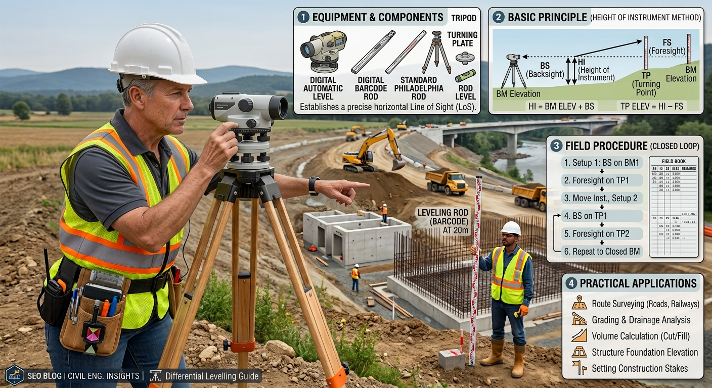
Introduction
Differential Levelling forms the foundation of modern surveying and civil engineering projects. Engineers rely on this surveying technique whenever two points lie far apart or sit at different elevations where direct levelling becomes impractical. Whether constructing highways, bridges, railways, buildings, canals, or pipelines, surveyors use differential levelling to determine accurate elevation differences and establish reliable benchmarks.
Every successful infrastructure project begins with precise vertical measurements. Even a small error in elevation can create drainage problems, uneven pavement surfaces, unstable foundations, or excessive construction costs. Differential levelling helps engineers maintain design accuracy from project planning to final construction.
This comprehensive guide explains Differential Levelling in simple yet professional language. It covers its definition, engineering principles, equipment, field procedure, practical examples, and best practices. The article also provides topic-related diagrams and practical insights for engineers, contractors, and civil engineering students.
What is Differential Levelling?
Differential Levelling is a surveying method used to determine the difference in elevation between two or more points that are separated by a considerable distance or where a single instrument setup cannot observe both points.
Instead of measuring all points from one position, the surveyor moves the level instrument several times. At every new setup, a backsight and a foresight reading establish the height relationship between successive points.
This method allows surveyors to transfer elevations accurately over long distances while maintaining high precision.
Definition
Differential levelling is the process of determining the reduced levels (RLs) of multiple points by taking a series of backsight (BS), intermediate sight (IS), and foresight (FS) readings from different instrument positions.
Main Objective
The primary objective of differential levelling is to establish accurate elevations that support engineering design, construction, and quality control.
Why Differential Levelling is Important
Almost every civil engineering project requires accurate elevation data. Designers cannot prepare safe and economical structures without reliable level information.
Differential levelling supports:
- Highway alignment design
- Bridge construction
- Railway projects
- Building foundations
- Canal construction
- Sewer networks
- Water supply systems
- Land development
- Airport construction
- Dam engineering
Engineering Importance
Accurate levelling helps engineers:
- Design efficient drainage systems.
- Calculate earthwork quantities.
- Establish construction benchmarks.
- Control pavement levels.
- Maintain design gradients.
- Prevent water accumulation.
- Improve construction accuracy.
Without proper levelling, even the most advanced design can fail during construction.
Principles of Differential Levelling
Differential levelling operates on a simple geometric principle.
When the levelling instrument is correctly adjusted, the line of sight remains perfectly horizontal. The difference between staff readings taken from this horizontal line determines the difference in elevation between points.
Basic Principle
- A smaller staff reading indicates a higher ground point.
- A larger staff reading indicates a lower ground point.
The surveyor repeatedly transfers the instrument while maintaining this principle throughout the survey.
Fundamental Terms
Benchmark (BM)
A benchmark is a permanent reference point with a known reduced level.
Backsight (BS)
The first reading taken on a benchmark or known point after setting up the instrument.
Intermediate Sight (IS)
Any reading taken between the backsight and foresight from the same instrument position.
Foresight (FS)
The final reading before shifting the instrument to a new location.
Change Point (CP)
A stable point used to transfer the level from one instrument setup to the next.
Reduced Level (RL)
The elevation of a point relative to an adopted datum, such as mean sea level.
Equipment Used in Differential Levelling
Accurate equipment ensures reliable survey results.
1. Levelling Instrument
The levelling instrument creates a precise horizontal line of sight.
Common types include:
- Dumpy Level
- Automatic Level
- Digital Level
- Tilting Level
Modern highway projects commonly use automatic and digital levels because they improve efficiency and accuracy.
2. Levelling Staff
The levelling staff is a graduated rod used to measure vertical distances from the line of sight.
Common materials include:
- Aluminum
- Fiberglass
- Wood
Typical staff lengths range from 3 m to 5 m.
3. Tripod Stand
The tripod provides a stable platform for the levelling instrument.
A firm setup minimizes vibrations and improves measurement accuracy.
4. Staff Bubble
A staff bubble helps keep the levelling staff perfectly vertical during observations.
Even slight tilting can introduce significant errors.
5. Measuring Tape
Surveyors use measuring tapes to locate stations and record distances where required.
6. Field Book
The field book records:
- Backsight readings
- Intermediate sights
- Foresight readings
- Reduced levels
- Remarks
- Station names
Accurate field notes reduce calculation errors and simplify project documentation.
Types of Differential Levelling
Different projects require different levelling methods.
Simple Differential Levelling
Engineers use this method when two points require multiple instrument setups because of distance or obstructions.
Fly Levelling
Fly levelling transfers benchmark elevations rapidly from one location to another with minimal intermediate observations.
Applications include:
- Establishing temporary benchmarks
- Beginning construction projects
- Closing survey loops
Check Levelling
Surveyors perform check levelling to verify previous observations and detect errors.
This method improves confidence in survey accuracy.
Profile Levelling
Profile levelling determines elevations along the centerline of roads, railways, canals, and pipelines.
Highway engineers frequently use this method during route design.
Cross-Section Levelling
Cross-section levelling measures elevations perpendicular to the project centerline.
Engineers use these measurements to calculate:
- Earthwork quantities
- Cut and fill volumes
- Side slopes
Reciprocal Levelling
Surveyors apply reciprocal levelling when obstacles such as rivers, valleys, or deep excavations prevent placing the instrument midway.
This method minimizes errors caused by curvature, refraction, and collimation.
Differential Levelling Procedure Step by Step
Accurate fieldwork depends on following a systematic procedure.
Step 1 – Select a Benchmark
Choose a benchmark with a known reduced level.
This serves as the starting reference.
Step 2 – Set Up the Instrument
Position the level securely on the tripod.
Adjust the leveling screws until the instrument is perfectly level.
Step 3 – Take the Backsight Reading
Hold the staff vertically on the benchmark.
Record the backsight reading.
Step 4 – Observe Intermediate Points
Take intermediate sight readings wherever elevation data is required.
Record every observation carefully.
Step 5 – Take the Foresight Reading
Record the foresight on a stable change point before moving the instrument.
Step 6 – Shift the Instrument
Move the level to a new location.
Repeat the backsight and foresight process until reaching the final point.
Step 7 – Compute Reduced Levels
Calculate elevations using either:
- Height of Instrument (HI) Method
- Rise and Fall Method
These calculation methods will be explained in Part 2.
Practical Field Example
Suppose engineers need to determine the elevation difference between two proposed bridge abutments separated by 600 meters.
A single instrument setup cannot cover the entire distance.
The survey team therefore:
- Starts from a benchmark with a known reduced level.
- Takes a backsight reading.
- Establishes several change points.
- Moves the instrument multiple times.
- Records foresight and backsight readings at each setup.
- Calculates the reduced level of the second abutment.
The resulting elevation data supports bridge foundation design, deck alignment, and drainage planning.
Topic-Related Diagram
Differential Levelling Setup
        Levelling Staff
             │
             │
          (BM)●
             │ BS
             │
        -------------------------
        |       LEVEL           |
        |     Instrument        |
        -------------------------
              ▲
            Tripod
              │
              │
       FS     │
             (CP)●
               │
        Shift Instrument
               │
               ▼
        -------------------------
        |       LEVEL           |
        |     Instrument        |
        -------------------------
              ▲
             BS
              │
             (CP)●
              │
             FS
              │
           Final Point ●
Differential Levelling Workflow
Known Benchmark
       │
       ▼
Instrument Setup
       │
       ▼
Backsight Reading
       │
       ▼
Intermediate Readings
       │
       ▼
Foresight Reading
       │
       ▼
Change Point
       │
       ▼
Shift Instrument
       │
       ▼
Repeat Process
       │
       ▼
Calculate Reduced Levels
Height of Instrument (HI) Method
The Height of Instrument (HI) Method is one of the most widely used techniques for calculating reduced levels during differential levelling. Engineers prefer this method because it offers a straightforward calculation process and suits large surveying projects.
The method first determines the height of the instrument above the chosen datum. Surveyors then calculate the reduced level of each observed point by subtracting the staff reading from the instrument height.
Formula
Height of Instrument (HI) = Reduced Level of Benchmark + Backsight
Reduced Level (RL) = Height of Instrument − Staff Reading
Example
Assume:
- Benchmark RL = 100.000 m
- Backsight = 1.250 m
Height of Instrument
HI = 100.000 + 1.250
HI = 101.250 m
If an intermediate staff reading equals 0.850 m, then:
RL = 101.250 − 0.850
RL = 100.400 m
This method allows engineers to calculate multiple reduced levels quickly from one instrument setup.
Advantages
- Simple calculation procedure.
- Faster field computations.
- Suitable for long projects.
- Easy to understand for beginners.
Limitation
The HI Method identifies calculation mistakes less effectively than the Rise and Fall Method because it does not verify every elevation change individually.
Rise and Fall Method
The Rise and Fall Method calculates elevation changes by comparing consecutive staff readings.
Instead of using instrument height, this method determines whether the ground rises or falls between two points.
Formula
- If the next staff reading is smaller, the ground rises.
- If the next staff reading is larger, the ground falls.
Reduced Level
New RL = Previous RL + Rise
New RL = Previous RL − Fall
Advantages
- Provides excellent accuracy.
- Detects calculation errors efficiently.
- Preferred for important engineering works.
- Suitable for precise leveling projects.
Limitation
The method requires more calculations than the Height of Instrument Method.
Sample Differential Levelling Field Book
| Station | BS (m) | IS (m) | FS (m) | HI (m) | RL (m) | Remarks |
|---|---|---|---|---|---|---|
| BM | 1.250 | — | — | 101.250 | 100.000 | Benchmark |
| A | — | 0.850 | — | 101.250 | 100.400 | Intermediate |
| B | — | 1.150 | — | 101.250 | 100.100 | Intermediate |
| CP1 | — | — | 1.900 | 101.250 | 99.350 | Change Point |
Maintaining an organized field book reduces mistakes and simplifies office calculations.
Arithmetic Check
Surveyors perform an arithmetic check after completing calculations.
The following relationship should remain true:
ΣBS − ΣFS = Last RL − First RL
Matching values indicate that the calculations are internally consistent. Any mismatch requires a review of field notes and computations.
Common Errors in Differential Levelling
Even experienced surveyors can encounter errors during fieldwork. Understanding these errors helps improve measurement accuracy.
Instrumental Errors
Examples include:
- Improper instrument adjustment.
- Bubble out of level.
- Collimation error.
- Damaged levelling staff.
Prevention
- Calibrate instruments regularly.
- Perform temporary adjustments before every survey.
- Inspect equipment before use.
Personal Errors
Surveyors sometimes introduce errors through incorrect observations.
Examples include:
- Misreading the staff.
- Incorrect field booking.
- Poor staff positioning.
- Recording values in the wrong column.
Prevention
- Double-check every reading.
- Keep the staff perfectly vertical.
- Review field notes before leaving the site.
Natural Errors
Environmental conditions can also affect measurements.
Examples include:
- Earth curvature.
- Atmospheric refraction.
- Wind vibration.
- Heat shimmer.
- Poor visibility.
Prevention
- Balance backsight and foresight distances.
- Avoid observations during extreme heat.
- Use reciprocal levelling across obstacles.
- Schedule surveys during stable weather conditions.
Practical Applications of Differential Levelling
Differential levelling supports numerous civil engineering and infrastructure projects.
Highway Engineering
Highway engineers use differential levelling to:
- Establish road centerline levels.
- Design longitudinal gradients.
- Determine cross slopes.
- Calculate cut-and-fill quantities.
- Set formation levels.
- Verify pavement elevations.
Railway Construction
Surveyors establish rail gradients and control track elevations to ensure safe and smooth train operations.
Building Construction
Contractors use differential levelling to:
- Set foundation levels.
- Transfer floor elevations.
- Verify plinth levels.
- Check slab heights.
Bridge Engineering
Bridge engineers rely on accurate elevation data for:
- Abutments.
- Piers.
- Deck levels.
- Approach roads.
Canal and Irrigation Projects
Levelling ensures the correct flow of water by maintaining the required longitudinal slope.
Pipeline Construction
Engineers establish proper invert levels for water supply, sewer, and drainage pipelines.
Best Practices for Differential Levelling
Professional surveyors follow proven practices to achieve reliable results.
- Inspect all equipment before fieldwork.
- Calibrate the levelling instrument regularly.
- Balance backsight and foresight distances.
- Use firm and stable change points.
- Keep the levelling staff vertical.
- Record observations immediately.
- Protect field books from damage.
- Repeat doubtful observations.
- Perform arithmetic checks before leaving the site.
- Verify benchmarks whenever possible.
These practices improve both accuracy and efficiency.
Practical Recommendations
Civil Engineers
- Verify benchmark elevations before beginning construction.
- Select the appropriate calculation method for the project.
- Review survey data before approving designs.
- Integrate levelling results with digital surveying software when available.
Contractors
- Protect established benchmarks throughout construction.
- Avoid disturbing change points.
- Coordinate survey activities with construction schedules.
- Confirm formation levels before placing pavement layers or concrete.
Engineering Students
- Practice both HI and Rise & Fall methods until calculations become familiar.
- Learn to maintain accurate field books.
- Participate in practical surveying exercises.
- Understand how levelling influences road design, drainage, and earthwork calculations.
General Discussion of IRC, AASHTO, and ICE Practices
Recognized engineering organizations such as IRC, AASHTO, and ICE emphasize the importance of accurate levelling during infrastructure development.
Their general recommendations include:
- Establish permanent benchmarks before construction.
- Use calibrated surveying instruments.
- Follow standardized field procedures.
- Verify elevations through independent checks.
- Maintain complete survey records.
- Integrate levelling with geotechnical and design data.
- Apply quality assurance throughout the project lifecycle.
Following these widely accepted principles helps engineers achieve safe, durable, and reliable infrastructure.
Frequently Asked Questions (FAQs)
1. What is Differential Levelling?
Differential Levelling is a surveying method used to determine the difference in elevation between distant points by taking observations from multiple instrument setups.
2. Why do engineers use Differential Levelling?
Engineers use it to establish accurate elevations for roads, bridges, buildings, railways, canals, pipelines, and other civil engineering projects.
3. What is the difference between Differential Levelling and Simple Levelling?
Simple levelling determines the elevation difference between two visible points from a single instrument setup, whereas differential levelling requires multiple setups when the points are too far apart or obstructed.
4. What is a Change Point?
A Change Point is a stable point used to transfer elevation from one instrument setup to the next during differential levelling.
5. Which calculation method is more accurate?
The Rise and Fall Method provides stronger arithmetic checks, while the Height of Instrument Method offers faster calculations for routine surveys.
6. What causes errors in Differential Levelling?
Instrument defects, observer mistakes, incorrect staff positioning, poor field recording, atmospheric refraction, and earth curvature can all introduce errors.
7. Why is a Benchmark important?
A Benchmark provides a known reference elevation that allows surveyors to calculate reduced levels accurately throughout the project.
8. Where is Differential Levelling commonly used?
It is widely used in highway engineering, railway construction, building projects, bridge works, irrigation canals, dams, airports, and utility infrastructure.
9. What equipment is required for Differential Levelling?
Typical equipment includes a levelling instrument, levelling staff, tripod, staff bubble, measuring tape, and field book.
10. How does Differential Levelling improve construction quality?
It ensures accurate elevations, proper drainage, correct structural levels, efficient earthwork calculations, and compliance with design specifications.
Conclusion
Differential Levelling remains one of the most essential surveying techniques in civil engineering because it delivers accurate elevation data for planning, design, and construction. From highways and bridges to buildings, canals, and utility networks, this method supports safe and efficient infrastructure development. Engineers achieve dependable results by understanding the principles of differential levelling, selecting the appropriate calculation method, maintaining calibrated equipment, and following systematic field procedures. Accurate observations, careful record-keeping, and routine arithmetic checks reduce errors and improve project quality. Adhering to the general guidance promoted by professional engineering organizations such as IRC, AASHTO, and ICE further strengthens reliability and consistency. Whether you are a student learning surveying fundamentals, a contractor executing site work, or an experienced engineer managing complex infrastructure projects, mastering Differential Levelling builds the confidence and technical foundation needed to produce precise elevations and successful construction outcomes.
