
Introduction
Modern highways, urban developments, industrial parks, and smart cities depend on more than roads and buildings. Hidden beneath and alongside every successful infrastructure project lies a carefully planned network of water pipelines, sewer systems, electrical cables, gas mains, fiber optic ducts, drainage structures, and communication lines. Without proper planning, these essential services can interfere with each other, increase construction costs, delay projects, and create long-term maintenance challenges.
This is where Utility Corridor Design becomes a critical part of civil and transportation engineering. A well-designed utility corridor ensures that multiple underground and above-ground services coexist safely while remaining accessible for future maintenance and expansion. It also minimizes conflicts with road structures, improves public safety, and reduces life-cycle costs.
This comprehensive guide explains every important aspect of Utility Corridor Design, including planning principles, design standards, engineering considerations, construction methods, common challenges, best practices, and recommendations followed by transportation agencies worldwide. Whether you are a civil engineering student, highway engineer, contractor, consultant, researcher, or infrastructure professional, this article will help you understand how effective utility corridor planning contributes to sustainable infrastructure development.
What is Utility Corridor Design?
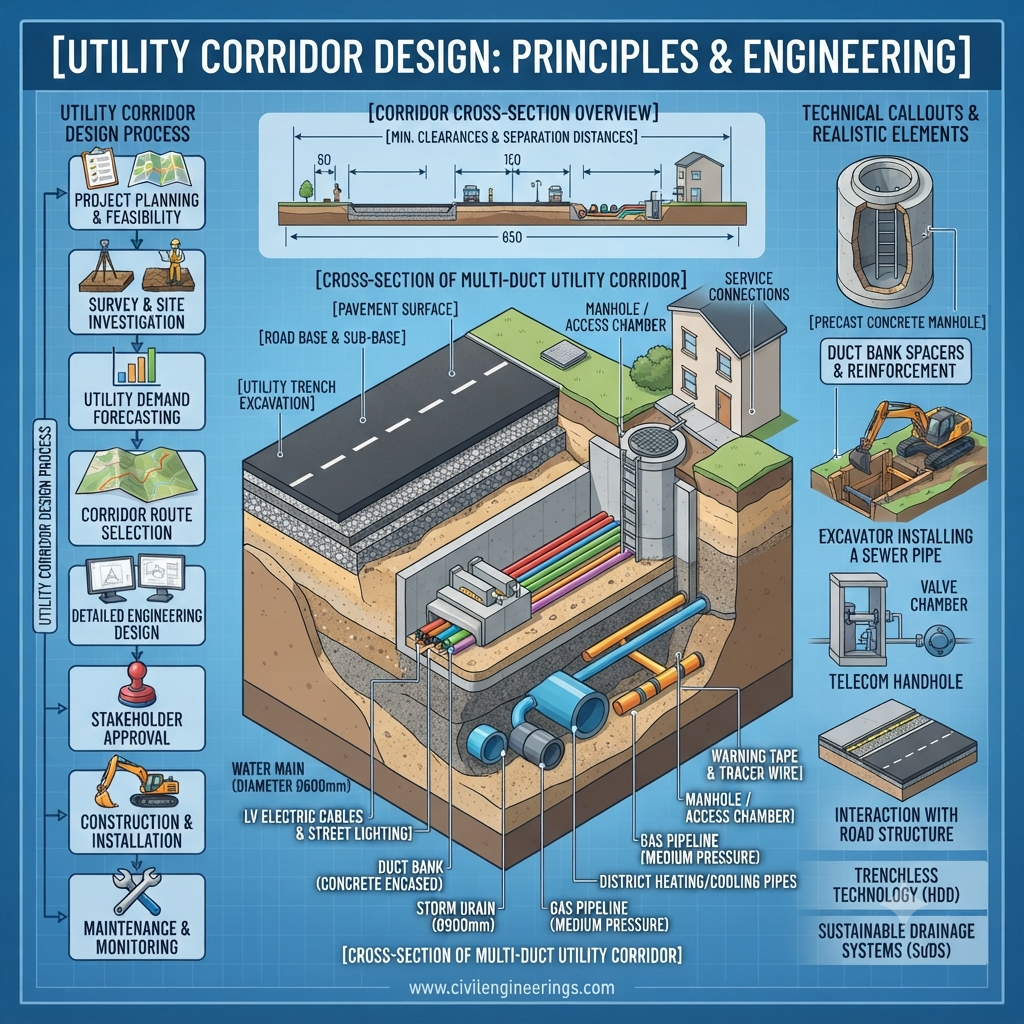
Utility Corridor Design is the engineering process of planning, locating, and organizing underground or above-ground utility systems within a designated corridor to ensure efficient installation, operation, maintenance, and future expansion.
A utility corridor provides dedicated space for multiple infrastructure services while minimizing interference between utilities and transportation facilities.
Typical utilities include:
- Water supply pipelines
- Sewer lines
- Stormwater drains
- Electrical transmission cables
- Gas pipelines
- Fiber optic cables
- Communication ducts
- District heating systems
The primary goal is to maximize functionality while reducing conflicts and maintenance costs.
Importance of Utility Corridor Design
Modern infrastructure cannot function without integrated utility networks. Poor planning often results in repeated road excavation, service interruptions, utility damage, and increased construction expenses.
Proper utility corridor planning provides numerous benefits:
- Reduces utility conflicts
- Improves construction efficiency
- Enhances public safety
- Supports future urban expansion
- Simplifies maintenance activities
- Protects transportation infrastructure
- Lowers lifecycle costs
- Improves project coordination
For highway projects, utility corridors preserve pavement integrity by reducing unnecessary trenching after road construction.
Objectives of Utility Corridor Planning
A successful utility corridor should achieve several engineering objectives:
- Maintain adequate separation between utilities.
- Provide easy maintenance access.
- Protect critical infrastructure.
- Ensure worker safety.
- Minimize relocation during future projects.
- Improve construction sequencing.
- Reduce environmental impacts.
- Support long-term infrastructure growth.
- Optimize land utilization.
- Improve service reliability.
Components of a Utility Corridor
Water Supply Networks
Water mains transport potable water to residential, commercial, and industrial areas. Designers must consider pressure zones, pipe materials, future demand, and accessibility for repairs.
Common pipe materials include:
- Ductile iron
- PVC
- HDPE
- Steel
- Concrete pressure pipes
Sewer Systems
Sanitary sewer lines require gravity flow wherever possible.
Design considerations include:
- Minimum slope
- Manhole spacing
- Invert levels
- Pipe capacity
- Maintenance access
Gravity systems reduce operational costs compared to pumped systems.
Stormwater Drainage
Drainage infrastructure removes runoff efficiently and protects highways against flooding.
Typical elements include:
- Culverts
- Catch basins
- Side drains
- Box culverts
- Retention systems
Drainage facilities often require larger corridor space than communication utilities.
Electrical Utilities
Electrical infrastructure may include:
- Underground power cables
- Distribution transformers
- Transmission ducts
- Junction boxes
Proper clearance from water and gas utilities is essential to minimize safety risks.
Gas Distribution Lines
Gas pipelines require strict safety measures due to explosion hazards.
Important considerations include:
- Minimum separation distances
- Corrosion protection
- Leak detection
- Emergency access
- Protective coatings
Telecommunication Infrastructure
Communication utilities continue expanding with smart city development.
Typical facilities include:
- Fiber optic ducts
- Internet cables
- Telephone lines
- Smart traffic communication systems
- Intelligent transportation system (ITS) cables
These systems require future spare conduits for expansion.
Types of Utility Corridors
Utility corridors can be classified according to location and construction method.
Underground Utility Corridors
Most urban projects use underground corridors to improve aesthetics and protect infrastructure.
Above-Ground Utility Corridors
Common in industrial facilities where maintenance accessibility is important.
Common Utility Ducts
Several utilities share one protected concrete duct system.
Multi-Utility Tunnels
Large cities increasingly use accessible underground tunnels housing multiple utility services.
Engineering Principles of Utility Corridor Design
Several engineering principles govern successful utility corridor planning.
Adequate Separation
Utilities require horizontal and vertical clearances to prevent interference and simplify maintenance.
Accessibility
Maintenance crews should access utilities without disturbing neighboring infrastructure.
Safety
Hazardous utilities should remain isolated from electrical and communication systems.
Future Expansion
Engineers should reserve additional corridor space for future development.
Constructability
Designs should allow practical installation using available construction equipment.
Lifecycle Cost Optimization
The initial construction cost should be balanced with long-term maintenance expenses.
Site Investigation and Data Collection
Accurate field information significantly improves utility corridor planning.
Essential investigations include:
- Topographic surveys
- Existing utility mapping
- Ground Penetrating Radar (GPR)
- Soil investigation
- Geological studies
- Groundwater assessment
- Environmental impact studies
- Traffic surveys
Utility detection technologies reduce the likelihood of accidental damage during excavation.
Utility Corridor Planning Process
A systematic planning process improves project success.
Step 1: Collect Existing Utility Records
Gather utility maps from local agencies and service providers.
Step 2: Conduct Field Verification
Verify utility locations using survey equipment and utility detection methods.
Step 3: Develop Corridor Layout
Prepare preliminary utility alignment drawings.
Step 4: Identify Utility Conflicts
Detect crossing points and incompatible utility locations.
Step 5: Optimize Alignment
Adjust utility locations while maintaining engineering requirements.
Step 6: Coordinate with Stakeholders
Consult utility companies, government agencies, and contractors.
Step 7: Prepare Final Design
Produce construction drawings, profiles, cross-sections, and specifications.
Design Standards and Guidelines
Although standards vary by country, several organizations provide widely accepted guidance.
IRC (Indian Roads Congress)
IRC guidelines discuss utility accommodation along highways, right-of-way management, drainage coordination, and road safety.
AASHTO
The American Association of State Highway and Transportation Officials provides guidance for utility accommodation, highway geometric design, and transportation infrastructure planning.
ICE
The Institution of Civil Engineers promotes sustainable infrastructure design, asset management, construction quality, and lifecycle engineering practices.
Engineers should always comply with local utility authorities and national regulations.
Utility Placement in Highway Projects
Utility placement must avoid compromising pavement performance.
Common placement practices include:
- Outside pavement edges whenever feasible
- Within designated right-of-way
- Behind sidewalks
- Beneath service roads
- Along green utility strips
Crossings should minimize disruption to traffic and pavement.
Horizontal directional drilling (HDD) is increasingly used beneath highways to reduce excavation.
Utility Conflict Management
Utility conflicts frequently delay infrastructure projects.
Common conflicts include:
- Water crossing gas pipelines
- Electrical cables near drainage systems
- Sewer interfering with bridge foundations
- Fiber optic ducts conflicting with retaining walls
Conflict resolution methods include:
- Alignment modification
- Vertical separation
- Utility relocation
- Protective casing
- Shared utility structures
Early coordination significantly reduces redesign costs.
Safety Considerations
Safety remains the highest priority throughout planning and construction.
Important safety measures include:
- Utility identification before excavation
- Emergency shutdown procedures
- Protective barriers
- Warning tapes
- Utility markers
- Safe trench excavation
- Confined space procedures
- Electrical isolation
Worker training further reduces accidents.
Sustainable Utility Corridor Design
Sustainability has become an essential design objective.
Modern utility corridors support sustainable development by:
- Reducing repeated excavation
- Lowering carbon emissions
- Conserving materials
- Improving maintenance efficiency
- Supporting smart infrastructure
- Facilitating renewable energy systems
- Protecting groundwater
- Reducing construction waste
Digital asset management also improves long-term sustainability.
Common Design Challenges
Engineers frequently encounter several practical difficulties.
These include:
- Congested urban environments
- Limited right-of-way
- Inaccurate utility records
- Unknown underground utilities
- Environmental restrictions
- Traffic management
- High groundwater levels
- Utility relocation costs
Comprehensive planning helps minimize these issues.
Best Practices
Successful projects consistently follow several proven practices.
- Perform detailed utility surveys.
- Coordinate with all stakeholders early.
- Use Building Information Modeling (BIM).
- Adopt Geographic Information Systems (GIS).
- Reserve future utility space.
- Maintain standard clearances.
- Document utility locations accurately.
- Implement quality assurance inspections.
- Review constructability before approval.
- Prepare emergency response plans.
Practical Recommendations for
Engineers
- Design with future expansion in mind.
- Use clash detection software.
- Review utility authority requirements carefully.
- Prioritize maintainability over short-term savings.
Contractors
- Verify utilities before excavation.
- Maintain accurate as-built drawings.
- Follow approved construction sequences.
- Protect existing infrastructure during installation.
Students
- Study utility coordination principles alongside highway design.
- Learn GIS and BIM applications.
- Understand underground utility mapping techniques.
- Familiarize yourself with international design standards.
Frequently Asked Questions (FAQs)
1. What is Utility Corridor Design?
Utility Corridor Design is the engineering process of organizing multiple utility systems within a dedicated corridor for safe installation, maintenance, and future expansion.
2. Why are utility corridors important?
They reduce utility conflicts, improve maintenance access, increase public safety, and lower infrastructure lifecycle costs.
3. Which utilities are normally included?
Water supply, sewer, stormwater drainage, gas pipelines, electrical cables, telecommunications, and fiber optic networks.
4. What software is commonly used for utility corridor design?
AutoCAD Civil 3D, Bentley OpenRoads, MicroStation, ArcGIS, BIM platforms, and utility management software are widely used.
5. What is utility conflict management?
It involves identifying and resolving conflicts between existing and proposed utilities before construction begins.
6. How does GIS improve utility planning?
GIS stores spatial utility data, improves mapping accuracy, supports maintenance planning, and assists future infrastructure development.
7. Why are separation distances important?
Proper clearances prevent interference, improve safety, and allow maintenance without damaging adjacent utilities.
8. What standards guide utility corridor design?
General guidance is commonly drawn from IRC, AASHTO, ICE publications, and local utility authority requirements.
9. How do utility corridors support smart cities?
They provide organized pathways for communication networks, intelligent transportation systems, renewable energy infrastructure, and future digital services.
10. What is the biggest challenge in utility corridor projects?
The greatest challenge is coordinating numerous utilities within limited space while maintaining safety, accessibility, and future flexibility.
Conclusion
Utility Corridor Design plays a fundamental role in developing reliable, efficient, and sustainable infrastructure. Effective planning allows water, sewer, drainage, electrical, gas, and communication systems to function together without unnecessary conflicts or costly relocations. By following sound engineering principles, conducting thorough site investigations, coordinating with stakeholders, and applying recognized guidance such as IRC, AASHTO, and ICE recommendations, engineers can create corridors that serve communities for decades.
Advances in GIS, BIM, utility detection technologies, and digital asset management continue to improve the way utility corridors are planned and maintained. These tools help reduce risks, optimize construction, and support smarter infrastructure networks. For civil engineering students, highway engineers, contractors, consultants, and government agencies, mastering Utility Corridor Design is essential for delivering resilient transportation projects, protecting public investment, and ensuring infrastructure remains adaptable to future growth. Well-designed utility corridors are not merely support systems—they are the backbone of modern infrastructure development.
