
Introduction
Every successful highway begins with a strong foundation, but even the strongest pavement can fail if water is not managed properly. Rainwater, groundwater, and runoff constantly threaten the structural integrity of roads. Without a well-designed drainage system, highways develop potholes, pavement cracks, erosion, slope failures, and reduced service life. This is why Highway Drainage Layout is considered one of the most important aspects of modern highway engineering.
A properly planned highway drainage layout safely collects, conveys, and disposes of surface and subsurface water before it damages the pavement or surrounding infrastructure. It improves road safety, reduces maintenance costs, increases pavement durability, and minimizes environmental impacts. Whether you are designing a new highway or upgrading an existing transportation corridor, an efficient drainage layout plays a vital role in the long-term performance of the project.
This comprehensive guide explains the principles, components, planning process, engineering considerations, and best practices involved in designing an effective Highway Drainage Layout. Civil engineering students, highway engineers, contractors, consultants, researchers, and government agencies will gain practical insights into developing reliable drainage systems that comply with modern engineering standards and industry practices.
What is Highway Drainage Layout?
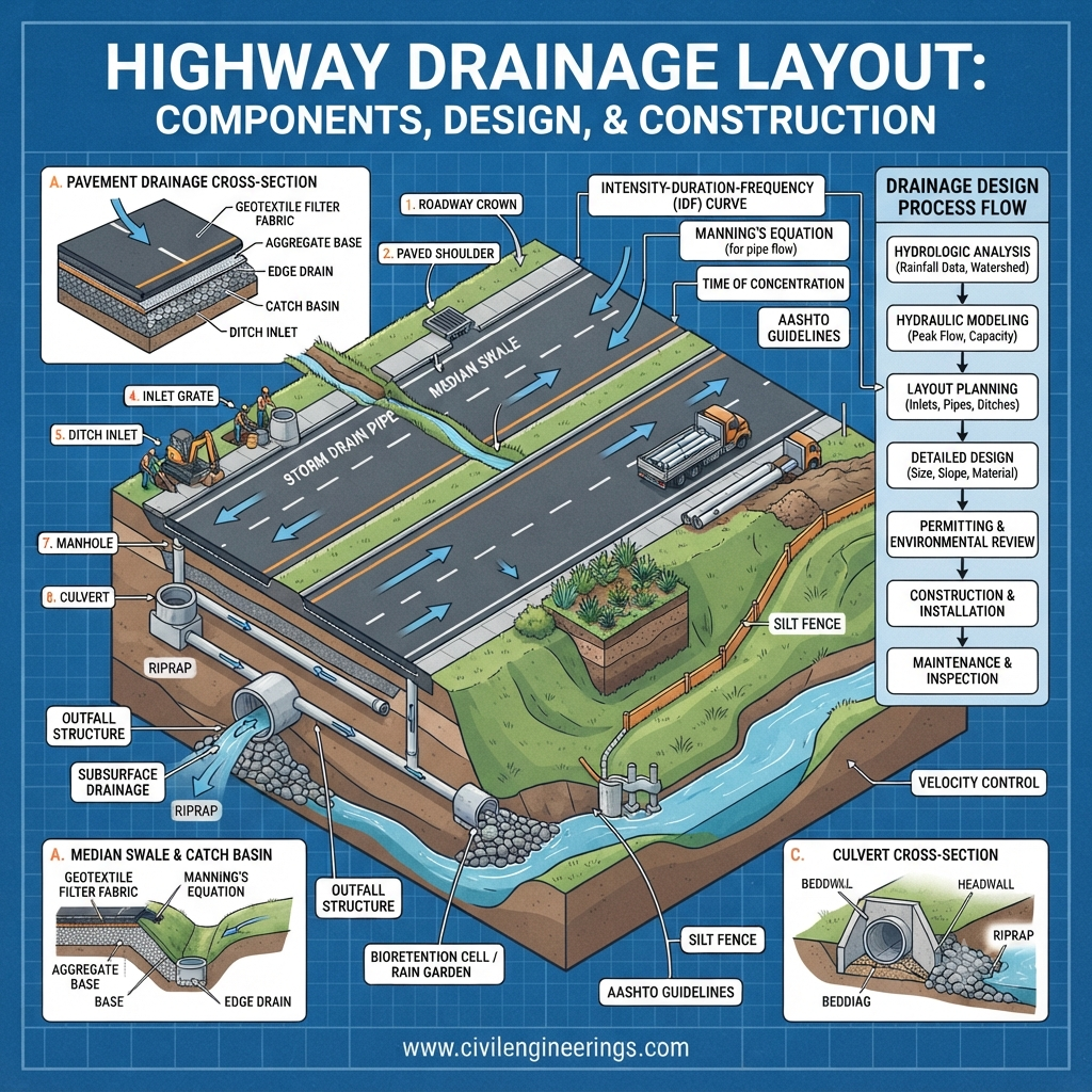
A Highway Drainage Layout is the systematic arrangement of drainage facilities designed to collect, control, convey, and safely discharge water from a highway corridor. The layout includes all surface and underground drainage elements that protect the pavement structure, embankments, slopes, and adjacent properties from water-related damage.
The drainage layout is prepared during the highway design stage after evaluating site conditions, rainfall patterns, topography, soil characteristics, groundwater levels, traffic requirements, and environmental constraints.
Its primary objective is to ensure that water never remains on or beneath the pavement for an extended period. Efficient drainage significantly enhances the service life of highways while reducing repair and maintenance costs.
A complete highway drainage layout generally consists of:
- Roadside drains
- Side ditches
- Catch basins
- Stormwater inlets
- Culverts
- Cross drains
- Median drains
- Longitudinal drains
- Subsurface drainage pipes
- Outfall structures
- Energy dissipation structures
Together, these elements create an integrated drainage network that efficiently manages stormwater throughout the highway corridor.
Importance of Highway Drainage Layout
Many highway failures are not caused by poor pavement materials or inadequate construction techniques. Instead, improper water management is often the underlying reason for premature deterioration. Even high-quality pavements lose strength when water infiltrates the pavement layers or saturates the subgrade.
An effective Highway Drainage Layout protects the investment made in highway infrastructure by ensuring that water is removed quickly and safely.
1. Increases Pavement Life
Water weakens the subgrade and reduces the bearing capacity of pavement layers. Continuous moisture accelerates pavement distress, including rutting, cracking, and pothole formation.
A properly designed drainage layout keeps pavement layers dry, significantly extending their service life.
2. Improves Road Safety
Standing water creates hazardous driving conditions. Hydroplaning, reduced tire grip, splash, and poor visibility increase the likelihood of traffic accidents.
Proper drainage removes water rapidly, allowing vehicles to maintain better traction during rainfall.
3. Prevents Soil Erosion
Highway embankments are particularly vulnerable to erosion when runoff flows unchecked down slopes. Erosion can undermine pavement edges, destabilize embankments, and expose structural layers.
Drainage channels and protective structures safely direct runoff while preserving slope stability.
4. Protects Highway Structures
Bridges, retaining walls, culverts, tunnels, and other highway structures are susceptible to water damage.
Efficient drainage minimizes corrosion, seepage, foundation weakening, and structural deterioration.
5. Reduces Maintenance Costs
Repairing drainage-related pavement failures often costs several times more than implementing proper drainage during construction.
Good drainage lowers maintenance frequency and reduces long-term operational expenses.
6. Supports Environmental Protection
Modern drainage systems help control sediment transport, reduce flooding, improve water quality, and minimize impacts on nearby ecosystems.
Environmental sustainability has become a key consideration in highway drainage planning.
Objectives of Highway Drainage Layout
Every drainage system is designed with specific engineering objectives that contribute to the overall performance and safety of the highway.
The primary objectives include:
- Remove stormwater quickly from the roadway surface.
- Prevent water infiltration into pavement layers.
- Protect the subgrade from saturation.
- Minimize erosion along embankments and cut slopes.
- Safely convey runoff to natural drainage channels.
- Reduce flooding risks along transportation corridors.
- Preserve pavement strength and structural capacity.
- Improve vehicle safety during adverse weather.
- Reduce long-term maintenance requirements.
- Comply with environmental regulations and engineering standards.
Achieving these objectives requires careful planning, hydraulic analysis, and proper integration of all drainage components.
Basic Engineering Principles of Highway Drainage Design
A successful Highway Drainage Layout is based on sound hydraulic and geotechnical engineering principles. Engineers must understand how water behaves under different site conditions and design the drainage system accordingly.
Rapid Removal of Surface Water
Water should never remain on the pavement for extended periods. Cross slopes, longitudinal grades, gutters, and roadside drains must work together to direct runoff toward designated drainage channels.
Quick removal reduces infiltration and enhances driving safety.
Gravity Flow
Most highway drainage systems operate using gravity. Water naturally flows from higher elevations to lower elevations without requiring mechanical pumping.
Proper grading ensures continuous flow and prevents water from accumulating in low areas.
Hydraulic Capacity
Each drainage component must be capable of conveying the expected design discharge generated during rainfall events.
Hydraulic calculations consider factors such as:
- Rainfall intensity
- Drainage area
- Runoff coefficient
- Flow velocity
- Channel roughness
- Pipe diameter
- Culvert capacity
Adequate hydraulic capacity prevents overtopping and localized flooding.
Prevention of Water Infiltration
Surface water should not enter pavement layers or the underlying subgrade. Dense pavement surfaces, sealed joints, edge drains, and proper shoulder design help limit water penetration.
Reducing infiltration preserves pavement strength and extends service life.
Safe Water Disposal
Collecting runoff is only part of the solution. The drainage layout must also provide safe outlets where water can be discharged without causing erosion or flooding.
Engineers often use:
- Natural streams
- Rivers
- Retention ponds
- Detention basins
- Stormwater channels
Energy dissipation structures may be installed at discharge points to reduce flow velocity and protect downstream areas.
Environmental Compatibility
Modern drainage systems are designed with environmental stewardship in mind. Sustainable practices aim to reduce erosion, control sediment, improve water quality, and maintain natural hydrological patterns.
Features such as vegetated swales, sediment traps, infiltration trenches, and bio-retention areas are increasingly incorporated into highway projects to manage runoff responsibly and support ecological balance.
Major Components of Highway Drainage Layout
A highway drainage layout combines several interconnected components, each serving a specific purpose in managing water efficiently. Understanding these elements is essential for designing a durable and safe transportation corridor.
Surface Drainage System
The surface drainage system is the first line of defense against rainfall. It is designed to remove water directly from the pavement surface before it can infiltrate the road structure.
Common components include:
- Pavement cross slopes (camber or superelevation)
- Roadside drains
- Side ditches
- Gutters
- Kerb channels
- Catch basins
- Stormwater inlets
These features guide runoff toward collection points and ensure rapid drainage during and after precipitation.
Subsurface Drainage System
Not all water remains on the surface. Groundwater and infiltrated moisture can accumulate beneath the pavement, reducing the strength of the base and subgrade layers.
Subsurface drainage systems remove this hidden moisture through:
- Perforated drainage pipes
- Edge drains
- Underdrains
- Filter layers
- Geotextile-wrapped drains
- Drainage blankets
By maintaining a dry pavement foundation, these systems help prevent pumping, frost damage, and long-term structural deterioration.
Cross Drainage Structures
Cross drainage structures carry water from one side of the highway to the other without interrupting natural watercourses.
Typical examples include:
- Pipe culverts
- Box culverts
- Arch culverts
- Small bridges
- Causeways
Their design depends on catchment area, peak discharge, hydraulic performance, and site conditions.
Longitudinal Drainage System
Longitudinal drainage channels run parallel to the roadway and transport collected runoff along the highway corridor toward designated outlets.
These systems commonly consist of:
- Side drains
- Median drains
- Open channels
- Closed stormwater pipes
Proper longitudinal drainage prevents water accumulation along road edges and supports continuous flow.
Outlet and Disposal System
Every drainage network must terminate at a safe discharge location. Outlet structures convey collected water into natural or engineered receiving systems while minimizing erosion and environmental impact.
Common outlet facilities include:
- Natural streams
- Rivers
- Retention ponds
- Detention basins
- Stormwater channels
- Energy dissipation structures
Careful outlet design ensures that runoff is released safely, protecting downstream properties and ecosystems.
Surface Drainage System Design
Surface drainage is the first and most visible component of a Highway Drainage Layout. Its purpose is to collect and remove rainwater from the pavement before it penetrates the road structure. Effective surface drainage prevents hydroplaning, minimizes pavement deterioration, and improves driving safety during adverse weather.
A well-designed surface drainage system should quickly intercept runoff, convey it through designated channels, and discharge it safely into natural or engineered drainage outlets.
1. Pavement Cross Slope (Camber)
The pavement cross slope, commonly known as camber, directs water from the center of the roadway toward the shoulders or side drains.
The cross slope must be steep enough to prevent water accumulation but not so steep that it affects vehicle stability or ride comfort.
Typical cross slopes include:
| Pavement Type | Typical Cross Slope |
|---|---|
| Asphalt Pavement | 2–2.5% |
| Cement Concrete Pavement | 1.5–2% |
| Gravel Roads | 3–5% |
Regular maintenance is essential to preserve the intended cross slope, as rutting and settlement can create depressions where water collects.
2. Longitudinal Gradient
A roadway also requires an adequate longitudinal slope to allow water to flow continuously toward drainage outlets.
If the longitudinal grade is too flat, runoff may stagnate even when the cross slope is correctly designed.
Engineers typically avoid long stretches with very low gradients unless supplemental drainage measures, such as additional inlets or stormwater pipes, are provided.
3. Roadside Drains
Roadside drains, also called side ditches, collect runoff from the carriageway, shoulders, and embankment slopes.
These drains may be:
- Trapezoidal drains
- Triangular drains
- Rectangular drains
- V-shaped drains
The choice depends on hydraulic capacity, available land, maintenance requirements, and soil conditions.
Proper lining with concrete, stone pitching, or vegetation reduces erosion and improves durability.
4. Gutters and Kerb Channels
Urban highways often use gutters and kerb channels to direct stormwater toward catch basins.
These facilities provide several advantages:
- Faster removal of runoff
- Protection of pedestrian walkways
- Reduced shoulder erosion
- Better traffic safety
Routine cleaning prevents debris accumulation that could obstruct flow.
5. Catch Basins and Stormwater Inlets
Catch basins collect runoff before it enters underground stormwater pipes.
Proper spacing depends on:
- Rainfall intensity
- Road gradient
- Drainage area
- Inlet capacity
- Traffic conditions
Placing inlets at low points, intersections, sag curves, and median openings helps prevent localized flooding.
Subsurface Drainage System Design
Surface drainage alone cannot protect a highway. Water may infiltrate through pavement joints, cracks, shoulders, or from groundwater beneath the roadway.
Subsurface drainage removes this hidden moisture before it weakens the pavement foundation.
Why Subsurface Drainage Matters
Excess moisture beneath the pavement can lead to:
- Reduced subgrade strength
- Pumping of fine particles
- Frost heave in cold climates
- Differential settlement
- Loss of bearing capacity
- Premature pavement failure
Keeping pavement layers dry significantly improves structural performance and service life.
Main Components
Edge Drains
Edge drains remove water entering through pavement edges and shoulders.
They usually consist of perforated pipes surrounded by filter aggregate and wrapped with geotextile fabric.
Underdrains
Underdrains intercept groundwater before it reaches the pavement structure.
They are especially useful in:
- Low-lying areas
- High groundwater zones
- Clay soils
- Flood-prone regions
Drainage Blanket
A drainage blanket is a permeable aggregate layer placed beneath the pavement.
Its functions include:
- Rapid drainage
- Pressure relief
- Moisture control
- Increased pavement durability
Geotextile Filters
Geotextiles prevent fine soil particles from entering drainage pipes while allowing water to pass freely.
This significantly reduces clogging and extends the operational life of the drainage system.
Highway Drainage Layout Planning Process
Developing an effective Highway Drainage Layout requires systematic planning and multidisciplinary coordination. Engineers must consider hydrology, hydraulics, geotechnics, environmental impacts, and future maintenance needs.
Step 1 – Site Investigation
Every drainage design begins with a detailed field investigation.
Engineers collect information on:
- Existing topography
- Natural drainage paths
- Soil characteristics
- Geological conditions
- Groundwater levels
- Existing utilities
- Nearby water bodies
Accurate site data reduces design errors and construction challenges.
Step 2 – Hydrological Analysis
Hydrological analysis estimates the quantity of runoff generated during rainfall events.
Key parameters include:
- Catchment area
- Rainfall intensity
- Rainfall duration
- Frequency of storms
- Runoff coefficient
- Land use
- Surface permeability
The Rational Method is commonly used for smaller highway drainage catchments:
Q = C × I × A
Where:
- Q = Peak runoff
- C = Runoff coefficient
- I = Rainfall intensity
- A = Catchment area
For larger watersheds, more advanced hydrological models may be adopted.
Step 3 – Hydraulic Design
Hydraulic design determines the size and capacity of drainage facilities.
Engineers calculate:
- Flow velocity
- Water depth
- Pipe diameter
- Culvert size
- Channel dimensions
- Head losses
The objective is to safely convey design flows without overtopping or excessive erosion.
Step 4 – Layout Development
Once hydraulic calculations are complete, engineers prepare the drainage layout.
The layout identifies the locations of:
- Side drains
- Catch basins
- Culverts
- Stormwater pipes
- Cross drains
- Outfalls
- Energy dissipation structures
Coordination with roadway geometry ensures efficient water movement throughout the corridor.
Step 5 – Environmental Assessment
Modern highway projects require careful evaluation of environmental impacts.
Drainage systems should:
- Reduce erosion
- Protect wetlands
- Maintain natural drainage patterns
- Improve water quality
- Minimize downstream flooding
Environmental considerations are now an integral part of sustainable highway engineering.
Hydraulic Design Considerations
Hydraulic performance determines whether a drainage system will function effectively under both normal and extreme storm conditions.
Engineers evaluate several critical factors.
Rainfall Intensity
Historical rainfall records are analyzed to determine the design storm.
Urban expressways often require larger design storms than rural highways because runoff accumulates rapidly over impervious surfaces.
Flow Velocity
Water should move fast enough to prevent sediment deposition but not so fast that it causes erosion.
Very high velocities can damage channels, embankments, and outlet structures.
Manning’s Equation
Open-channel flow is commonly analyzed using Manning’s Equation:
V = (1/n) × R^(2/3) × S^(1/2)
Where:
- V = Velocity
- n = Manning’s roughness coefficient
- R = Hydraulic radius
- S = Channel slope
This equation helps determine the appropriate dimensions for roadside drains and open channels.
Culvert Capacity
Culverts must safely convey peak flood flows without causing upstream ponding or downstream erosion.
Design factors include:
- Pipe diameter
- Barrel length
- Entrance conditions
- Outlet conditions
- Tailwater depth
- Debris potential
Key Engineering Factors Affecting Highway Drainage Layout
Several engineering variables influence the final drainage design.
Topography
Terrain controls runoff direction, drainage patterns, and outlet locations.
Mountainous regions require different drainage strategies than flat plains.
Soil Type
Different soils have different infiltration capacities.
Examples include:
- Sand → High permeability
- Gravel → Excellent drainage
- Clay → Poor drainage
- Silt → Moderate drainage
Understanding soil behavior helps determine whether infiltration or rapid conveyance is the preferred design approach.
Climate
Climate influences rainfall frequency, storm intensity, and seasonal groundwater levels.
Regions with heavy monsoon rainfall require larger drainage capacities than arid areas.
Traffic Loading
High-volume highways demand stronger drainage protection because pavement failures disrupt traffic and increase maintenance costs.
Heavy truck traffic also accelerates deterioration if moisture weakens the pavement structure.
Future Expansion
Drainage systems should accommodate future road widening whenever practical.
Oversized culverts and strategically placed stormwater infrastructure can reduce future reconstruction costs.
General Guidance from IRC, AASHTO, and ICE
Although design requirements vary by country and project, respected engineering organizations provide valuable guidance for highway drainage planning.
IRC (Indian Roads Congress)
IRC publications emphasize:
- Efficient surface drainage
- Adequate shoulder protection
- Proper culvert spacing
- Embankment stability
- Erosion control
- Maintenance accessibility
AASHTO (American Association of State Highway and Transportation Officials)
AASHTO recommends:
- Hydrology-based drainage design
- Risk-based storm selection
- Pavement moisture protection
- Safe hydraulic performance
- Long-term durability
- Integration of drainage with geometric design
ICE (Institution of Civil Engineers)
ICE promotes sustainable drainage principles, including:
- Environmental protection
- Resilient infrastructure
- Climate adaptation
- Whole-life asset management
- Low-maintenance drainage systems
These organizations collectively reinforce the importance of designing drainage systems that are technically sound, economically efficient, environmentally responsible, and easy to maintain.
Practical Recommendations for
Highway Engineers
- Begin drainage planning during the preliminary design stage rather than after geometric design is complete.
- Validate hydrological assumptions using reliable rainfall and catchment data.
- Coordinate drainage layouts with utilities, structures, and roadway alignment to avoid construction conflicts.
Site Engineers
- Verify field elevations before excavation to ensure the designed drainage gradients are achieved.
- Inspect drainage pipes, culverts, and joints before backfilling to prevent hidden defects.
- Maintain proper compaction around drainage structures to minimize settlement.
Contractors
- Keep drainage channels free from construction debris throughout the project.
- Protect completed drains from damage caused by heavy equipment and temporary access roads.
- Follow approved specifications for filter materials, geotextiles, and pipe installation.
Civil Engineering Students
- Build a strong understanding of hydrology, hydraulics, soil mechanics, and pavement engineering, as these disciplines are closely linked in drainage design.
- Practice preparing drainage layouts using CAD and civil design software while learning how engineering calculations support each design decision.
Best Practices for Highway Drainage Layout
An efficient Highway Drainage Layout goes beyond meeting minimum design standards. It should provide reliable performance throughout the highway’s design life while remaining economical to construct and maintain. Applying proven engineering practices helps reduce maintenance costs, improve road safety, and increase pavement longevity.
1. Begin Drainage Planning Early
Drainage should be integrated into the preliminary highway design rather than treated as a separate activity after the road alignment is finalized. Early planning allows engineers to optimize roadway geometry, drainage structures, and earthworks together, reducing costly redesigns during construction.
2. Use Accurate Hydrological Data
Reliable rainfall records, watershed characteristics, and runoff estimates are essential for selecting appropriate drainage capacities. Using outdated or incomplete data may result in undersized or oversized drainage structures.
Whenever possible, engineers should utilize long-term rainfall data and approved hydrological models for design.
3. Maintain Continuous Water Flow
Every drainage component should maintain uninterrupted flow from collection to discharge.
Avoid:
- Dead-end drains
- Flat channel sections
- Reverse slopes
- Sudden changes in alignment
- Inadequate outlet capacity
Continuous flow reduces sediment deposition and minimizes maintenance requirements.
4. Protect Against Erosion
Fast-moving runoff can damage embankments, roadside slopes, and drainage channels.
Common erosion protection measures include:
- Riprap
- Concrete lining
- Stone pitching
- Turfing
- Gabions
- Energy dissipation basins
- Check dams
Selecting suitable erosion control measures depends on flow velocity, soil type, and environmental conditions.
5. Design for Easy Maintenance
Even the best drainage system requires routine inspection and maintenance.
Engineers should ensure that:
- Culverts remain accessible.
- Catch basins can be cleaned efficiently.
- Inspection chambers are properly located.
- Drainage channels allow safe access for maintenance crews.
Accessibility reduces maintenance costs and extends the service life of drainage infrastructure.
6. Consider Climate Change
Many regions now experience more intense and frequent rainfall than historical records indicate.
Modern drainage design should account for:
- Extreme storm events
- Increased runoff
- Flash flooding
- Future climate uncertainty
Where appropriate, additional freeboard and reserve hydraulic capacity can improve long-term resilience.
7. Incorporate Sustainable Drainage Solutions
Sustainable Drainage Systems (SuDS) help reduce runoff while improving water quality and environmental performance.
Examples include:
- Vegetated swales
- Bio-retention cells
- Infiltration trenches
- Rain gardens
- Detention basins
- Retention ponds
- Permeable shoulders
These features support groundwater recharge, reduce downstream flooding, and promote sustainable highway infrastructure.
Common Highway Drainage Design Mistakes
Even experienced engineers can encounter drainage-related issues if important design considerations are overlooked. Recognizing common mistakes helps improve project quality and reduce future maintenance.
Undersized Culverts
Culverts that cannot convey the design flood often cause upstream flooding, roadway overtopping, and embankment damage.
Hydraulic capacity should always be verified for the selected return period.
Poor Cross Slope
Insufficient pavement cross slope allows water to pond on the road surface, increasing the risk of hydroplaning and pavement deterioration.
Proper construction control is essential to achieve the specified camber.
Ignoring Groundwater
Some projects focus only on surface runoff while neglecting groundwater conditions.
High groundwater levels can weaken the pavement foundation and shorten pavement life if underdrain systems are not provided where required.
Inadequate Drainage Maintenance
Blocked drains, sediment-filled ditches, and clogged culverts reduce drainage efficiency.
Without routine cleaning, even a well-designed system may fail during heavy rainfall.
Improper Outlet Design
Discharging runoff directly onto unprotected slopes or channels can trigger severe erosion.
Outfalls should include suitable energy dissipation and erosion protection measures.
Lack of Coordination
Drainage layouts should be coordinated with:
- Utility corridors
- Bridge structures
- Retaining walls
- Traffic safety features
- Landscaping
- Environmental mitigation measures
Good coordination prevents construction conflicts and costly modifications.
Inspection and Maintenance of Highway Drainage Systems
Routine maintenance is essential to preserve the performance of a Highway Drainage Layout throughout its service life.
Routine Inspection
Regular inspections should identify:
- Sediment accumulation
- Blocked culverts
- Damaged pipes
- Cracked drainage channels
- Vegetation growth
- Erosion
- Settlement
- Water ponding
Inspection frequency should increase before and during the rainy season.
Preventive Maintenance
Preventive maintenance is more cost-effective than emergency repairs.
Typical maintenance activities include:
- Removing debris from inlets
- Cleaning culverts
- Flushing stormwater pipes
- Repairing damaged channel linings
- Restoring embankment protection
- Controlling vegetation
A preventive maintenance program helps maintain hydraulic capacity and reduces the likelihood of unexpected failures.
Post-Storm Inspection
After major storm events, engineers should inspect:
- Culvert inlets and outlets
- Side drains
- Pavement shoulders
- Embankment slopes
- Bridge approaches
- Drainage outfalls
Early identification of damage prevents small defects from developing into major structural problems.
Future Trends in Highway Drainage Engineering
Highway drainage is evolving alongside advancements in digital technology and sustainable infrastructure.
Smart Drainage Monitoring
Sensors and Internet of Things (IoT) devices can monitor water levels, flow rates, and blockage conditions in real time. These systems enable faster maintenance responses and improve asset management.
GIS and BIM Integration
Geographic Information Systems (GIS) and Building Information Modeling (BIM) allow engineers to integrate terrain data, drainage networks, utilities, and structures into a single digital model. This improves design coordination and lifecycle management.
Nature-Based Solutions
Increasingly, highway projects incorporate green infrastructure such as constructed wetlands, vegetated channels, and infiltration systems to manage stormwater while enhancing biodiversity and water quality.
Resilient Infrastructure
Future drainage designs are expected to place greater emphasis on resilience, ensuring that highways continue to function safely during extreme weather events caused by climate change.
Frequently Asked Questions (FAQs)
1. What is a Highway Drainage Layout?
A Highway Drainage Layout is the planned arrangement of surface and subsurface drainage facilities that collect, convey, and safely discharge water from a highway to protect the pavement, embankments, and surrounding infrastructure.
2. Why is highway drainage important?
Proper drainage prevents water accumulation, protects pavement layers, reduces erosion, improves road safety, extends pavement life, and lowers maintenance costs.
3. What are the main components of a highway drainage system?
The primary components include pavement cross slopes, roadside drains, gutters, catch basins, stormwater pipes, culverts, underdrains, edge drains, median drains, and outlet structures.
4. What is the difference between surface drainage and subsurface drainage?
Surface drainage removes water from the roadway surface, while subsurface drainage removes infiltrated water and groundwater from beneath the pavement structure.
5. How is the design discharge for highway drainage determined?
Engineers estimate design discharge using hydrological methods such as the Rational Method or other approved runoff models, considering rainfall intensity, catchment area, runoff coefficient, and local design standards.
6. Which standards are commonly referred to for highway drainage design?
Engineers commonly consult guidance published by the Indian Roads Congress (IRC), the American Association of State Highway and Transportation Officials (AASHTO), and the Institution of Civil Engineers (ICE), along with national highway agency specifications.
7. What problems occur if highway drainage is poorly designed?
Poor drainage can cause pavement cracking, rutting, potholes, subgrade weakening, embankment erosion, flooding, slope instability, and increased maintenance costs.
8. How often should highway drainage systems be inspected?
Routine inspections are recommended throughout the year, with additional inspections before the rainy season and immediately after major storm events.
9. How do sustainable drainage systems improve highway performance?
Sustainable drainage systems reduce runoff, improve water quality, limit downstream flooding, support groundwater recharge, and enhance environmental sustainability.
10. What software is commonly used for highway drainage design?
Engineers often use software such as AutoCAD Civil 3D, OpenRoads Designer, HEC-HMS, HEC-RAS, EPA SWMM, and MicroDrainage (or equivalent drainage design tools) for planning, hydraulic analysis, and drainage network design.
Conclusion
An efficient Highway Drainage Layout is one of the most critical elements of successful highway engineering. While pavement materials, geometric design, and construction quality all contribute to road performance, none can achieve their full potential without effective water management. A well-planned drainage layout protects the pavement structure, preserves the strength of the subgrade, reduces erosion, minimizes flood risks, and enhances road safety for all users.
Designing a reliable drainage system requires a balanced understanding of hydrology, hydraulics, geotechnical engineering, environmental considerations, and long-term maintenance. By integrating surface drainage, subsurface drainage, cross-drainage structures, and sustainable stormwater management practices, engineers can create resilient highway infrastructure that performs efficiently for decades. Following established guidance from organizations such as IRC, AASHTO, and ICE, together with regular inspection and maintenance, ensures that the Highway Drainage Layout continues to deliver safe, durable, and cost-effective performance throughout the highway’s service life.
