
Introduction
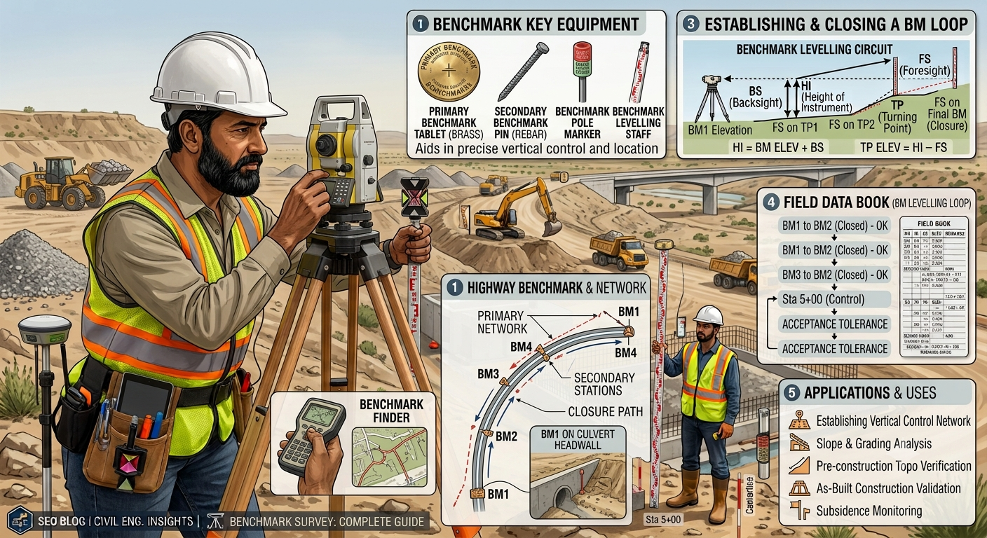
A Benchmark Survey forms the foundation of every successful civil engineering and road construction project. Before engineers design highways, bridges, buildings, or drainage systems, they must establish a reliable reference point for measuring elevations. Accurate benchmark data ensures that every structure follows the approved design levels and remains safe throughout its service life.
Survey engineers use benchmarks to transfer elevations from one location to another with precision. These permanent or temporary reference points eliminate measurement errors, improve construction quality, and support effective project management. Whether constructing a national highway, a railway corridor, or a commercial building, engineers depend on benchmark surveys to maintain consistency from project planning to final completion.
Understanding the principles, types, equipment, and procedures of a Benchmark Survey helps engineers, contractors, and students improve surveying accuracy while reducing costly construction mistakes. This guide explains the complete benchmark survey process using practical engineering concepts, field examples, and industry best practices.
What is a Benchmark Survey?
A Benchmark Survey is a surveying process that establishes a fixed reference point with a known elevation. Surveyors use this reference to determine the heights of other points on a construction site.
A benchmark provides a permanent vertical control point. Every elevation measurement during planning, design, construction, and maintenance refers back to this point.
Unlike horizontal control surveys, benchmark surveys focus on vertical measurements. Engineers use leveling instruments to transfer elevations accurately across the project area.
Simple Definition
A benchmark is a fixed point whose elevation is known relative to a recognized datum, such as mean sea level or a project-specific reference level.
Why is a Benchmark Survey Important?
Every construction project depends on accurate elevation data. A small error during leveling can affect drainage, pavement thickness, bridge deck levels, and foundation depths.
A benchmark survey helps engineers:
- Maintain accurate design levels.
- Control excavation and filling operations.
- Ensure proper drainage slopes.
- Improve construction quality.
- Reduce surveying errors.
- Support quality control during construction.
- Simplify future maintenance work.
Without reliable benchmark data, construction teams may face costly corrections, delays, and safety concerns.
Types of Benchmarks
Survey engineers establish different types of benchmarks depending on project requirements.
1. GTS Benchmark (Great Trigonometrical Survey)
A GTS Benchmark is the highest level of surveying reference. National surveying organizations establish these benchmarks using highly accurate geodetic observations.
Characteristics
- Fixed permanently.
- Connected to national leveling networks.
- Elevation referenced to Mean Sea Level (MSL).
- Used for major infrastructure projects.
Applications
- National highways
- Railways
- Airports
- Large dams
- Metro projects
2. Permanent Benchmark
Government departments, municipalities, or highway authorities establish permanent benchmarks for long-term engineering projects.
These benchmarks remain available for future surveys and maintenance work.
Common Locations
- Bridge abutments
- Concrete monuments
- Government buildings
- Retaining walls
- Culvert headwalls
Advantages
- High reliability
- Easy relocation
- Long service life
- Suitable for repeated surveys
3. Temporary Benchmark (TBM)
Engineers create temporary benchmarks during active construction when permanent benchmarks are not nearby.
The construction team uses these points until project completion.
Typical Locations
- Concrete blocks
- Steel pegs
- Stable rocks
- Utility poles
- Permanent fence posts
Applications
- Road construction
- Building projects
- Canal construction
- Utility installation
4. Arbitrary Benchmark
An arbitrary benchmark uses an assumed elevation instead of a nationally recognized datum.
Engineers generally assign a convenient value, such as 100.000 m, to simplify calculations.
When It Is Used
- Small construction projects
- Short-duration surveys
- Internal site leveling
- Preliminary investigations
Although arbitrary benchmarks provide convenience, engineers should avoid them for large public infrastructure projects that require integration with national survey networks.
Engineering Principles of Benchmark Survey
A benchmark survey follows several fundamental engineering principles that ensure consistent and accurate elevation measurements.
1. Fixed Reference Point
The benchmark must remain stable throughout the project. Any movement of the benchmark affects every subsequent measurement.
2. Accurate Leveling
Surveyors establish elevations using precise leveling techniques. They keep the instrument properly calibrated and verify readings regularly.
3. Error Control
Engineers perform back-sight and fore-sight observations to detect measurement errors. Closing the leveling loop helps verify survey accuracy.
4. Consistent Datum
Every elevation within the project must reference the same datum. Mixing different reference levels creates confusion and construction errors.
5. Proper Documentation
Survey teams record benchmark descriptions, coordinates, elevations, sketches, and photographs. Good documentation allows future surveyors to locate the benchmark easily.
Equipment Used in Benchmark Survey
Modern surveying combines traditional instruments with advanced digital technology.
Automatic Level
The automatic level remains the most common instrument for benchmark surveys. It provides accurate horizontal sight lines with minimal adjustment.
Digital Level
Digital levels improve accuracy by automatically reading bar-coded leveling staffs and reducing human error.
Dumpy Level
Many educational institutions still use dumpy levels to teach leveling principles and basic surveying techniques.
Leveling Staff
A leveling staff is a graduated scale that surveyors hold vertically on the point being measured.
Tripod Stand
A stable tripod supports the leveling instrument and minimizes movement during observations.
Measuring Tape
Surveyors use measuring tapes to locate benchmark positions and verify field dimensions.
GPS/GNSS Equipment
Modern highway projects often integrate Global Navigation Satellite System (GNSS) receivers to establish control points before detailed leveling begins.
Step-by-Step Benchmark Survey Procedure
A systematic procedure improves survey accuracy and reduces field errors.
Step 1: Select a Stable Benchmark Location
Choose a permanent, accessible location that will remain undisturbed throughout the project.
Examples include:
- Concrete monuments
- Bridge structures
- Large stable rocks
- Reinforced concrete pillars
Step 2: Set Up the Level Instrument
Place the tripod on firm ground and mount the level securely.
Check that:
- The tripod remains stable.
- The instrument is level.
- The telescope focuses clearly.
- Bubble adjustments are correct.
Step 3: Take the Back Sight (BS)
Place the leveling staff on the benchmark and record the first reading.
This reading establishes the Height of Instrument (HI).
Step 4: Observe Intermediate and Fore Sight Readings
Move the leveling staff to each required survey point.
Record:
- Intermediate Sight (IS)
- Fore Sight (FS)
Calculate elevations using standard leveling methods.
Step 5: Establish Temporary Benchmarks
Large highway projects require several temporary benchmarks across the construction corridor.
These additional reference points reduce survey distances and improve efficiency.
Step 6: Verify Survey Accuracy
Surveyors perform closing checks by returning to the original benchmark or another known benchmark.
Any difference beyond acceptable tolerance requires investigation and correction.
Practical Field Example
Consider a highway widening project that extends for 15 kilometers.
The survey team begins by locating a government permanent benchmark near the project site. Using an automatic level, they transfer elevations along the proposed alignment and establish temporary benchmarks every 500 meters. These reference points guide excavation, embankment construction, culvert installation, and pavement leveling throughout the project.
Because every contractor uses the same benchmark network, construction levels remain consistent from start to finish.
Benchmark Survey Diagram
Relationship Between Benchmark and Construction Points
                  Benchmark (RL = 100.000 m)
                           ●
                           │
                 Back Sight (BS)
                           │
                  Automatic Level
                    ───────────
                           │
          ┌────────────────┼────────────────┐
          │                │                │
      Point A          Point B         Point C
    (Excavation)     (Road Center)   (Culvert)

Known RL → Height of Instrument → New Reduced Levels
Basic Leveling Process
Known Benchmark
      │
      ▼
Back Sight Reading
      │
      ▼
Height of Instrument
      │
      ▼
Intermediate Readings
      │
      ▼
Fore Sight Reading
      │
      ▼
Reduced Levels of New Points
Benchmark Survey in Highway Projects
A Benchmark Survey plays a vital role in every stage of highway development. Engineers rely on accurate elevation data to construct roads that meet design specifications, provide efficient drainage, and deliver long-term performance. Every vertical measurement on a highway project begins from an established benchmark.
During highway construction, survey teams establish permanent and temporary benchmarks along the project corridor. These reference points help maintain consistent elevations from the start of earthwork to the final pavement layer.
Major Applications in Highway Engineering
1. Route Planning
Surveyors determine ground elevations before selecting the final highway alignment. Accurate benchmark data helps engineers compare alternative routes and estimate earthwork quantities.
2. Earthwork Operations
Construction teams use benchmarks to control excavation and embankment levels. Correct elevations reduce unnecessary cutting and filling while improving project efficiency.
3. Pavement Construction
Every pavement layer requires precise thickness. Benchmarks guide surveyors in maintaining the required formation level, subgrade elevation, sub-base thickness, base course level, and finished road surface.
4. Bridge Construction
Bridge engineers transfer benchmark elevations to foundations, piers, abutments, bearings, and bridge decks. Accurate leveling prevents structural alignment problems.
5. Drainage System Installation
Proper drainage depends on accurate gradients. Benchmarks help engineers establish correct invert levels for culverts, side drains, stormwater channels, and cross-drainage structures.
6. Utility Installation
Water pipelines, sewer lines, communication ducts, and electrical conduits require precise elevation control. Benchmark surveys ensure these utilities maintain the correct slopes and depths.
Practical Applications of Benchmark Survey
Benchmark surveys support a wide range of civil engineering projects beyond highways.
Road Construction
Survey teams maintain consistent pavement elevations throughout construction.
Railway Projects
Engineers establish rail track levels to achieve smooth train operations and safe track geometry.
Airport Runways
Runway construction requires highly accurate elevations to provide proper drainage and safe aircraft movement.
Dam Construction
Benchmark surveys control foundation excavation, spillway elevations, and reservoir structures.
Building Construction
Builders use benchmarks to establish foundation levels, floor elevations, and roof heights.
Canal and Irrigation Projects
Surveyors maintain the required channel gradients to ensure efficient water flow.
Common Benchmark Survey Errors
Even experienced surveyors can encounter errors if they fail to follow proper field procedures. Identifying these issues early helps maintain survey accuracy.
Instrument Setup Errors
Poor tripod stability or improper leveling affects every observation.
Solution
- Set up the instrument on firm ground.
- Check the bubble level before taking readings.
- Reconfirm instrument stability after moving the tripod.
Staff Position Errors
A tilted leveling staff produces incorrect readings.
Solution
- Hold the staff perfectly vertical.
- Use a staff bubble where available.
- Train assistants to maintain proper positioning.
Reading Errors
Incorrect recording or misreading the staff creates inaccurate reduced levels.
Solution
- Read measurements carefully.
- Record values immediately.
- Cross-check calculations before leaving the site.
Benchmark Disturbance
Heavy equipment or construction activities may damage temporary benchmarks.
Solution
- Protect benchmark locations.
- Install warning markers.
- Inspect benchmarks regularly.
- Replace damaged benchmarks immediately.
Calculation Errors
Incorrect addition or subtraction affects all subsequent elevations.
Solution
- Verify calculations twice.
- Use digital data collectors when possible.
- Perform closing checks after each leveling loop.
Best Practices for Benchmark Survey
Professional survey teams follow standardized procedures to improve accuracy and reliability.
- Establish benchmarks on stable and permanent structures.
- Use calibrated surveying instruments.
- Check instrument adjustments before fieldwork.
- Maintain balanced back-sight and fore-sight distances.
- Protect benchmark locations from disturbance.
- Record benchmark descriptions with sketches and photographs.
- Perform independent checks on leveling calculations.
- Verify elevations using closing surveys.
- Maintain complete field records for future reference.
- Train survey personnel in proper leveling techniques.
These practices improve data quality and reduce construction errors.
Practical Recommendations
Civil Engineers
- Verify benchmark elevations before approving construction activities.
- Coordinate survey work with design and construction teams.
- Maintain updated benchmark registers throughout the project.
- Review leveling reports before issuing site instructions.
Contractors
- Protect established benchmarks during construction.
- Inform survey teams before disturbing nearby structures.
- Schedule regular benchmark verification during major earthworks.
- Use qualified surveyors for critical leveling operations.
Engineering Students
- Practice differential leveling during field training.
- Learn both manual and digital surveying techniques.
- Understand the relationship between benchmarks and reduced levels.
- Develop strong field recording habits.
- Study real construction projects to observe benchmark applications.
General Discussion of IRC, AASHTO, and ICE Practices
Leading engineering organizations emphasize the importance of accurate vertical control in infrastructure projects.
IRC (Indian Roads Congress)
IRC guidance highlights reliable surveying, accurate leveling, proper documentation, and consistent elevation control throughout highway construction.
AASHTO
AASHTO recommends detailed survey control before design and construction. Engineers should verify benchmark accuracy, maintain quality assurance, and support pavement design with dependable elevation data.
ICE (Institution of Civil Engineers)
ICE promotes systematic surveying practices, professional competence, effective documentation, and continuous quality management throughout the project lifecycle.
Although project specifications vary by country, these organizations share common engineering principles that focus on precision, consistency, and quality.
Field Checklist for Benchmark Survey
Before starting the survey:
Verify benchmark location.
Inspect the leveling instrument.
Check tripod stability.
Confirm staff condition.
Prepare field book.
Review survey drawings.
During the survey:
Balance sight distances.
Record observations immediately.
Protect benchmark locations.
Verify calculations.
After completing the survey:
Perform closing checks.
Compare calculated elevations.
Prepare survey reports.
Update benchmark records.
Frequently Asked Questions (FAQs)
1. What is a benchmark survey in civil engineering?
A benchmark survey establishes a fixed reference point with a known elevation. Engineers use this point to determine the elevations of other locations during planning, design, and construction.
2. Why is a benchmark important in road construction?
A benchmark ensures consistent elevation control for excavation, embankments, pavement layers, drainage systems, bridges, and utility installations.
3. What is the difference between a benchmark and a temporary benchmark?
A permanent benchmark remains available for long-term use, while a temporary benchmark serves only during an active construction project.
4. Which instrument is commonly used for benchmark surveys?
Surveyors commonly use automatic levels, digital levels, dumpy levels, leveling staffs, and GNSS equipment depending on project requirements.
5. What is Reduced Level (RL)?
Reduced Level represents the elevation of a point relative to a selected datum such as Mean Sea Level or an approved project benchmark.
6. How often should benchmarks be verified?
Survey teams should verify benchmarks before major construction activities, after heavy earthworks, and whenever there is a possibility of disturbance.
7. Can GPS replace benchmark surveys?
GNSS technology improves survey efficiency, but engineers still perform precise leveling to achieve the accuracy required for many highway and structural projects.
8. What causes errors during benchmark surveys?
Common causes include unstable instruments, tilted staffs, poor calculations, disturbed benchmarks, incorrect observations, and inadequate documentation.
9. Why do highway engineers establish temporary benchmarks?
Temporary benchmarks reduce survey distances, improve field efficiency, and maintain consistent elevation control across long construction corridors.
10. What qualities define a good benchmark?
A good benchmark remains stable, accessible, clearly identified, well documented, protected from damage, and suitable for repeated use throughout the project.
Conclusion
A Benchmark Survey forms the backbone of accurate elevation control in civil engineering and highway construction. Every successful project depends on reliable reference points that guide excavation, embankment construction, pavement placement, drainage installation, and structural works. Engineers achieve consistent results by selecting stable benchmark locations, using calibrated surveying equipment, following systematic leveling procedures, and verifying measurements through regular quality checks. Contractors benefit from fewer construction errors, improved productivity, and reduced rework when benchmark data remains accurate and well protected. Students who understand benchmark surveying develop stronger field skills and gain a solid foundation for advanced surveying and highway engineering. By applying recognized engineering practices and maintaining precise documentation, project teams can deliver safe, durable, and high-quality infrastructure. Mastering the Benchmark Survey process not only improves construction accuracy but also supports efficient project execution, long-term maintenance, and sustainable infrastructure development.
