
Introduction
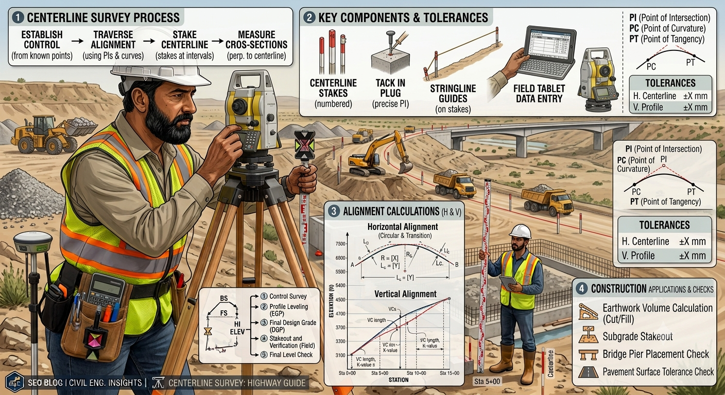
A Centerline Survey forms the backbone of every successful road and highway project. Engineers use this survey to establish the exact position of the proposed road alignment before design and construction begin. Every pavement layer, bridge, culvert, drainage structure, and safety feature depends on the accuracy of the centerline. Even a small surveying error can increase construction costs, create land acquisition issues, or reduce road safety.
Modern road projects rely on precise surveying methods combined with advanced equipment such as Total Stations, GNSS receivers, digital levels, and drones. These technologies help engineers achieve accurate horizontal and vertical alignment while reducing field errors and improving project efficiency.
Whether you are a civil engineer, surveyor, contractor, or engineering student, understanding the Centerline Survey process will strengthen your knowledge of highway planning and geometric design. This guide explains the purpose, principles, equipment, procedures, practical applications, and best practices used during a centerline survey in modern road engineering.
What Is a Centerline Survey?
A Centerline Survey is the process of locating and marking the exact horizontal and vertical alignment of a proposed road, highway, railway, canal, or pipeline. The centerline represents the reference line from which engineers measure every structural element during design and construction.
In highway engineering, the centerline serves as the primary control line for:
- Road alignment
- Earthwork calculations
- Pavement layout
- Drainage design
- Bridge positioning
- Utility relocation
- Right-of-way limits
- Construction staking
Without an accurately established centerline, construction teams cannot maintain the required geometry or meet design specifications.
Why Is a Centerline Survey Important?
Every highway begins with an accurate alignment. The centerline survey ensures that the proposed route follows the approved design while minimizing construction challenges.
Key Benefits
- Improves construction accuracy.
- Reduces costly rework.
- Supports proper geometric design.
- Helps calculate earthwork quantities.
- Simplifies construction staking.
- Improves road safety.
- Ensures consistent pavement width.
- Assists land acquisition planning.
- Supports drainage design.
- Enhances project efficiency.
Practical Importance
Imagine a four-lane highway passing through rolling terrain. If surveyors place the centerline incorrectly, engineers may need additional excavation, larger retaining walls, or redesigned drainage structures. Accurate surveying during the planning stage prevents these issues and saves significant time and money.
Objectives of a Centerline Survey
A centerline survey achieves several important engineering objectives.
Primary Objectives
- Establish the exact road alignment.
- Define horizontal and vertical control.
- Locate important natural and man made features.
- Provide reference points for design.
- Support earthwork calculations.
- Guide construction staking.
- Improve project accuracy.
- Reduce alignment conflicts.
- Maintain design consistency.
Every subsequent design activity relies on the data collected during this survey.
Engineering Principles Behind a Centerline Survey
A successful centerline survey follows established surveying and highway engineering principles to ensure accuracy and consistency.
Horizontal Alignment
Horizontal alignment defines the path of the road when viewed from above. Engineers use tangents and curves to create a smooth route that meets the required design speed and safety standards.
Key Elements
- Tangents
- Circular curves
- Transition curves
- Deflection angles
- Intersection points (PI)
A well-designed horizontal alignment improves driver comfort and reduces accident risks.
Vertical Alignment
Vertical alignment represents the road profile along its length. Engineers design gradients and vertical curves to provide smooth elevation changes while maintaining visibility and drainage.
Important components include:
- Longitudinal gradients
- Crest curves
- Sag curves
- Formation levels
Survey Control
Survey control provides the reference framework for all field measurements.
Control points should remain:
- Stable
- Easily identifiable
- Protected from disturbance
- Precisely coordinated
Permanent benchmarks improve accuracy throughout the project lifecycle.
Equipment Used for a Centerline Survey
Modern highway surveys use advanced instruments that deliver high accuracy and improve productivity.
Total Station
A Total Station measures horizontal angles, vertical angles, and distances with exceptional precision. It combines electronic distance measurement with digital angle measurement, making it one of the most widely used instruments in highway surveying.
GNSS/GPS Receiver
Global Navigation Satellite System (GNSS) receivers determine precise geographic coordinates. Engineers use them for establishing control points, mapping corridors, and integrating survey data with GIS software.
Digital Level
A digital level measures elevation differences quickly and accurately. It simplifies profile leveling and benchmark verification.
Automatic Level
Engineers often use an automatic level for routine leveling operations and construction staking.
Survey Prism
A survey prism reflects the Total Station’s signal, enabling accurate distance measurements.
Measuring Tape and Survey Chain
These tools remain useful for short-distance measurements and field checks.
Survey Pegs and Stakes
Surveyors place wooden or metal stakes to mark the proposed centerline, control points, and station locations.
Drone Survey (UAV)
Many modern projects use drones to capture aerial imagery, create digital terrain models, and improve route planning.
Centerline Survey Procedure Step by Step
Step 1: Review Project Data
Before entering the field, engineers examine all available project information.
They review:
- Topographic maps
- Preliminary alignment
- Design drawings
- Satellite imagery
- Existing utilities
- Previous survey records
This preparation helps identify potential challenges and improves field efficiency.
Step 2: Establish Survey Control Points
The survey team establishes permanent horizontal and vertical control points across the project area.
These points serve as the foundation for every subsequent measurement.
Activities
- Install benchmarks.
- Record coordinates.
- Verify elevations.
- Protect control monuments.
- Document control descriptions.
Accurate control points reduce cumulative measurement errors.
Step 3: Conduct the Preliminary Reconnaissance
The reconnaissance survey allows engineers to inspect the proposed corridor before detailed measurements begin.
During this visit, the team identifies:
- Existing roads
- Rivers
- Buildings
- Utility lines
- Bridges
- Hills
- Valleys
- Vegetation
- Access routes
The observations help engineers confirm or refine the proposed alignment.
Step 4: Mark the Proposed Centerline
After completing reconnaissance, surveyors stake the proposed centerline in the field.
The staking process includes:
- Setting centerline pegs at regular intervals.
- Marking curve points.
- Identifying tangent sections.
- Numbering survey stations.
- Recording coordinates.
Each stake represents a reference point that guides future construction activities.
Step 5: Measure Horizontal Alignment
Surveyors then measure the horizontal geometry of the alignment using Total Stations or GNSS equipment.
Measurements include:
- Bearings
- Deflection angles
- Curve lengths
- Radius of curvature
- Tangent lengths
- Station coordinates
Engineers compare these measurements with design requirements and make adjustments where necessary.
Accurate horizontal alignment ensures smooth vehicle movement, consistent lane geometry, and safe operating speeds.
Practical Example
A transportation agency plans a new 25-kilometer bypass around a growing city. The survey team begins by establishing permanent control points using GNSS receivers. They then carry out a reconnaissance survey to identify rivers, existing roads, and utility corridors. After reviewing the terrain, the team stakes the proposed centerline at 20-meter intervals and measures the horizontal alignment with a Total Station. The collected data enables designers to prepare precise geometric layouts, estimate earthwork quantities, and optimize drainage structures before construction starts.
Centerline Survey Workflow Diagram
Project Planning
        │
        ▼
Review Existing Maps & Drawings
        │
        ▼
Establish Survey Control Points
        │
        ▼
Reconnaissance Survey
        │
        ▼
Stake Proposed Centerline
        │
        ▼
Measure Horizontal Alignment
        │
        ▼
Profile & Cross-Section Survey
        │
        ▼
Prepare Survey Data & Drawings
        │
        ▼
Engineering Design
Step 6: Measure Vertical Alignment
After completing the horizontal alignment, the survey team measures the vertical profile of the proposed road. This stage determines the elevation of the centerline at regular intervals and creates the foundation for designing gradients and vertical curves.
A well-planned vertical alignment improves driving comfort, supports proper drainage, and reduces unnecessary earthwork.
Main Activities
- Establish benchmark elevations.
- Carry out profile leveling.
- Measure ground levels at each survey station.
- Record changes in terrain elevation.
- Identify high and low points.
Engineering Importance
Accurate elevation data allows engineers to:
- Design safe road gradients.
- Balance cut and fill quantities.
- Improve surface drainage.
- Reduce construction costs.
- Increase driver visibility.
Step 7: Record Cross Sections
Cross-section surveying measures the ground profile perpendicular to the centerline. These measurements help engineers understand the terrain on both sides of the proposed road.
Cross sections play an essential role in geometric design and quantity estimation.
Information Collected
- Existing ground levels
- Side slopes
- Ditches
- Embankments
- Natural drains
- Utility locations
- Property boundaries
Applications
Cross-section data supports:
- Earthwork calculations
- Slope design
- Retaining wall design
- Drainage planning
- Pavement width determination
Practical Example
If the survey identifies a steep natural slope on one side of the alignment, the design team may include retaining walls or modify the side slope to improve stability and reduce excavation.
Step 8: Verify Alignment Accuracy
Before finalizing survey data, engineers verify every measurement to eliminate errors.
Survey verification improves accuracy and prevents costly corrections during construction.
Verification Activities
- Recheck control points.
- Confirm station coordinates.
- Verify elevations.
- Compare field notes with digital data.
- Check curve calculations.
- Inspect benchmark stability.
Common Verification Methods
- Closed traverse checks
- Independent observations
- GPS coordinate comparison
- Total Station remeasurement
- Digital data validation
Quality verification strengthens confidence in the final survey results.
Step 9: Prepare Survey Drawings
Once fieldwork is complete, engineers process the collected data and prepare detailed survey drawings.
These drawings become the foundation for highway design and construction.
Drawings Typically Include
- Centerline plan
- Longitudinal profile
- Cross sections
- Contour maps
- Control point layout
- Existing utilities
- Drainage features
- Property boundaries
Software Commonly Used
- AutoCAD Civil 3D
- Bentley OpenRoads
- Trimble Business Center
- GIS software
- Survey data processing tools
Digital drawings improve coordination between surveyors, designers, and contractors.
Step 10: Final Review and Approval
The final stage includes reviewing all survey information before design begins.
Senior engineers verify that the survey satisfies project requirements and applicable standards.
Final Checklist
- Control points verified
- Horizontal alignment approved
- Vertical profile completed
- Cross sections reviewed
- Field notes checked
- Digital drawings finalized
- Coordinate system confirmed
- Data backed up
After approval, the survey data moves to the highway design team.
Common Errors in Centerline Surveys
Even experienced survey teams can face challenges. Recognizing common mistakes helps maintain survey quality.
Frequent Errors
- Incorrect instrument calibration
- Poor benchmark protection
- Inaccurate control points
- Recording mistakes
- Wrong coordinate system
- Insufficient field checks
- Ignoring terrain obstacles
- Improper stake placement
- Failure to verify measurements
How to Prevent These Errors
- Calibrate equipment regularly.
- Protect all survey monuments.
- Use standardized field procedures.
- Perform independent accuracy checks.
- Train survey personnel continuously.
- Review field data daily.
- Maintain detailed survey records.
Best Practices for a Centerline Survey
Following proven engineering practices improves accuracy and project efficiency.
Recommended Practices
- Review project documents before fieldwork.
- Establish reliable horizontal and vertical control.
- Use modern surveying equipment.
- Perform routine instrument calibration.
- Verify measurements through independent observations.
- Record field data clearly and consistently.
- Protect survey benchmarks throughout construction.
- Store digital survey files securely.
- Coordinate closely with design engineers.
- Conduct final quality assurance before issuing survey reports.
Practical Recommendations
Civil Engineers
- Review survey data before preparing geometric designs.
- Confirm coordinate systems and benchmark elevations.
- Coordinate survey activities with geotechnical investigations.
- Evaluate terrain conditions during alignment selection.
Contractors
- Verify construction staking before excavation.
- Protect survey control points from equipment damage.
- Report discrepancies immediately.
- Follow approved survey drawings during construction.
Engineering Students
- Learn both traditional and modern surveying techniques.
- Practice Total Station and GNSS operations.
- Understand profile leveling and cross-section surveys.
- Develop strong field note and data processing skills.
General Discussion of IRC, AASHTO, and ICE Practices
Leading road engineering organizations promote accurate surveying as the foundation of successful highway projects.
General recommendations include:
- Establish stable survey control before detailed fieldwork.
- Use precise instruments for horizontal and vertical measurements.
- Verify survey data through independent checks.
- Integrate geotechnical, environmental, and topographic information into alignment decisions.
- Maintain comprehensive documentation throughout the project lifecycle.
- Apply quality assurance procedures at every stage of the survey.
Following these principles improves design accuracy, construction quality, and long-term roadway performance.
Practical Applications of Centerline Survey
A Centerline Survey supports a wide range of infrastructure projects, including:
- National highways
- Expressways
- Rural roads
- Urban streets
- Railway corridors
- Airport runways
- Canal systems
- Pipeline routes
- Transmission line corridors
- Industrial access roads
Its versatility makes it one of the most important surveying activities in civil engineering.
Centerline Survey Process Diagram
Project Planning
        │
        ▼
Control Points Established
        │
        ▼
Centerline Staking
        │
        ▼
Horizontal Survey
        │
        ▼
Vertical Profile Survey
        │
        ▼
Cross-Section Survey
        │
        ▼
Data Verification
        │
        ▼
Survey Drawings
        │
        ▼
Engineering Design
Frequently Asked Questions (FAQs)
1. What is a centerline survey in road construction?
A centerline survey establishes the exact reference line for a proposed road or highway. Engineers use this line to guide alignment, design, earthwork calculations, and construction activities.
2. Why is a centerline survey important?
It ensures accurate road alignment, minimizes construction errors, improves geometric design, and supports efficient project execution.
3. Which equipment is commonly used for a centerline survey?
Survey teams commonly use Total Stations, GNSS receivers, digital levels, automatic levels, drones, prisms, measuring tapes, and survey stakes.
4. What is the difference between a centerline survey and a topographic survey?
A centerline survey focuses on the proposed alignment, while a topographic survey maps the existing terrain, natural features, and man made structures over a wider area.
5. How often are survey stations placed along the centerline?
Station spacing depends on project requirements. Engineers often place stations at regular intervals, such as every 20 or 25 meters, with additional points on curves and significant terrain changes.
6. What role does a centerline survey play in earthwork calculations?
The survey provides profile and cross-section data that engineers use to estimate cut and fill quantities accurately.
7. How does GNSS improve centerline surveys?
GNSS delivers highly accurate coordinate data, reduces field time, and simplifies integration with GIS and design software.
8. Why are cross sections important?
Cross sections reveal terrain variations, assist with slope design, and support drainage planning and quantity estimation.
9. How do engineers verify survey accuracy?
They remeasure control points, perform closed traverse checks, compare digital records with field notes, and validate coordinates using independent observations.
10. Can drones replace traditional surveying equipment?
Drones enhance data collection and terrain mapping, but engineers still rely on Total Stations, GNSS receivers, and leveling instruments for precise control and construction staking.
Conclusion
A Centerline Survey provides the framework for every successful highway and road construction project. From establishing control points and measuring horizontal and vertical alignment to recording cross sections and preparing detailed survey drawings, each step contributes to accurate engineering design and efficient construction. Reliable survey data reduces costly errors, improves safety, optimizes earthwork, and supports long-term pavement performance. Modern technologies such as GNSS, Total Stations, and drones have increased survey accuracy and productivity, yet careful planning, skilled fieldwork, and thorough verification remain equally important. Engineers, contractors, and students who understand the complete Centerline Survey process can make better technical decisions, improve project coordination, and deliver infrastructure that meets modern engineering standards. By combining proven surveying principles with quality assurance and industry best practices, organizations can achieve durable, safe, and cost-effective transportation projects that serve communities for decades.
