
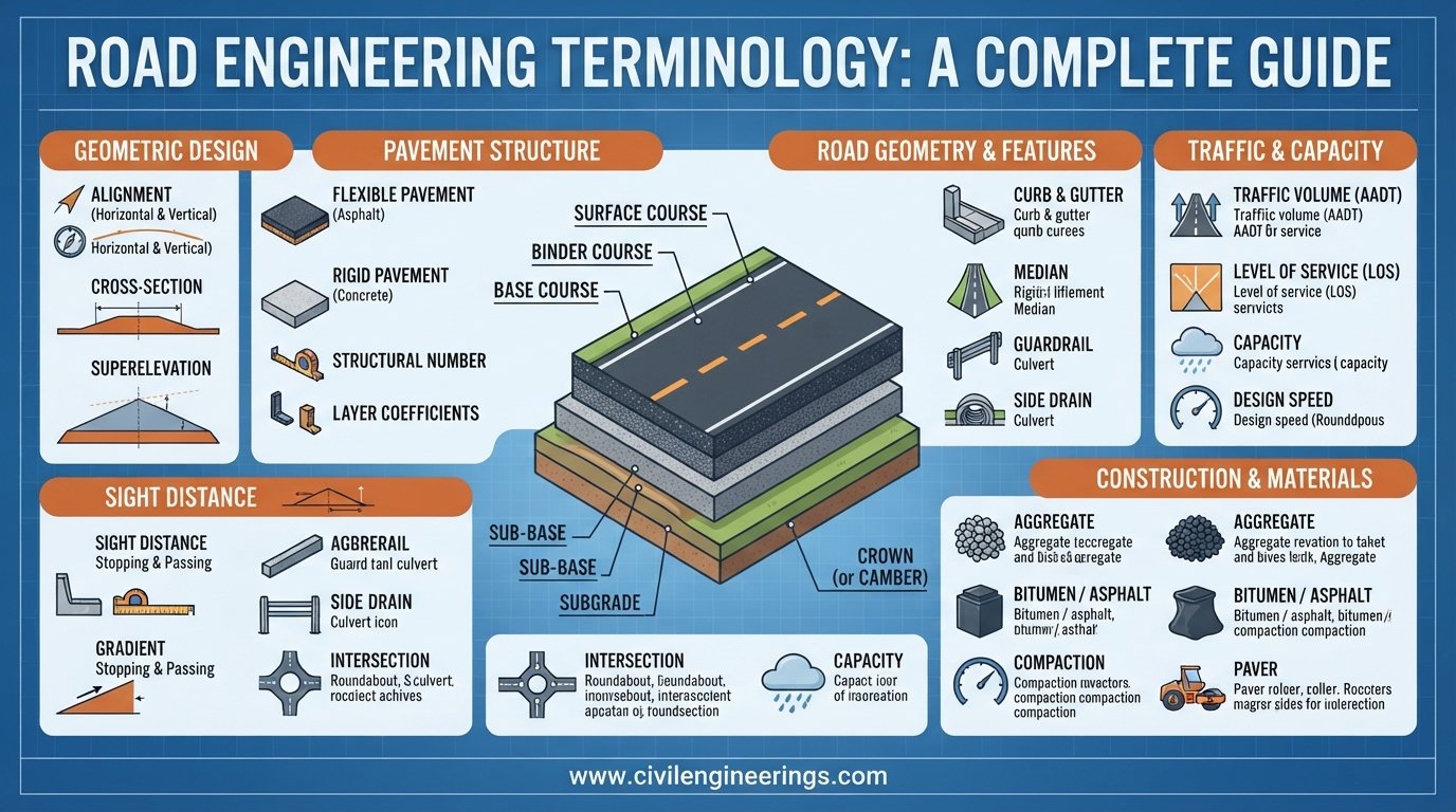
Every engineering discipline has its own technical language, and road construction is no exception. On a highway project, a single term can describe a geometric feature, pavement layer, construction activity, material property, traffic condition, or quality-control requirement. Understanding these terms helps engineers communicate accurately and make better decisions in the field.
Road Engineering Terminology forms the foundation of highway planning, geometric design, pavement engineering, construction supervision, surveying, maintenance, and road safety. A student may encounter terms such as camber, gradient, sight distance, formation level, subgrade, and right of way in textbooks, while a site engineer deals with the same concepts during setting out, earthwork, pavement construction, and inspection.
This guide explains the most important road engineering terms in practical language. It covers road alignment, geometric design, pavement layers, materials, earthwork, drainage, traffic engineering, construction, surveying, safety, and maintenance. General principles used by organizations and references such as IRC, AASHTO, and ICE are also discussed where relevant.
Whether you are a civil engineering student, highway engineer, contractor, consultant, or infrastructure professional, this terminology guide can serve as a practical reference for understanding the language used throughout a road project’s life cycle.
Road Alignment and Geometric Design Terminology
Road alignment describes the position and direction of a road on the ground. Engineers develop alignment in both the horizontal and vertical planes while considering terrain, traffic, safety, drainage, environmental constraints, land acquisition, and construction cost.
Alignment
Alignment is the planned position of a road centerline relative to the surrounding terrain. It has two principal components:
- Horizontal alignment
- Vertical alignment
A good alignment provides safe vehicle operation, reasonable construction cost, adequate sight distance, and comfortable driving conditions.
Horizontal Alignment
Horizontal alignment represents the road layout when viewed from above. It normally consists of straight sections called tangents and curves used to change direction.
Common horizontal curve types include:
- Simple circular curve
- Compound curve
- Reverse curve
- Transition curve
Horizontal Curve
A horizontal curve allows a vehicle to change direction gradually rather than making a sudden turn.
For a simple circular curve, the relationship between radius and degree of curvature depends on the adopted definition. In basic geometric work, the larger the radius, the flatter the curve and the more comfortable the movement.
Transition Curve
A transition curve connects a tangent and a circular curve. Its curvature changes progressively from zero at the tangent to the required curvature of the circular curve.
Transition curves help:
- Improve riding comfort
- Introduce centrifugal effects gradually
- Provide space for developing superelevation
- Improve vehicle control
- Reduce sudden steering changes
Vertical Alignment
Vertical alignment defines the road profile along its longitudinal direction. It consists mainly of grades connected by vertical curves.
The design must consider terrain, drainage, sight distance, vehicle performance, earthwork quantities, and required clearances.
Vertical Curve
A vertical curve provides a smooth change between two different grades.
Two common types are:
- Summit or crest curve: convex upward
- Sag curve: concave upward
Vertical curves are particularly important for maintaining adequate sight distance and smooth vehicle operation.
Gradient
Gradient is the rate at which road elevation changes with horizontal distance.
The basic formula is:
Gradient (%) = (Vertical Rise or Fall / Horizontal Distance) × 100
For example, if a road rises 2 m over a horizontal distance of 100 m:
Gradient = (2 / 100) × 100 = 2%
A steep gradient may increase fuel consumption and reduce the performance of heavy vehicles. Excessively flat grades can also create drainage problems where longitudinal drainage is inadequate.
Camber or Crossfall
Camber, also called crossfall, is the transverse slope provided on the road surface to drain rainwater toward the edge.
Adequate crossfall reduces water infiltration into pavement layers and improves skid resistance by preventing excessive surface water.
The appropriate value depends on pavement type, rainfall, material, road standards, and construction requirements.
Superelevation
Superelevation is the transverse slope provided on a horizontal curve by raising the outer edge of the pavement relative to the inner edge.
It helps counteract the lateral effects experienced by vehicles negotiating a curve.
A simplified relationship used in highway design is:
e + f = V² / (127R)
Where:
- e = superelevation rate
- f = side-friction factor
- V = speed in km/h
- R = curve radius in metres
The exact design procedure and limiting values should follow the governing road authority’s standards.
Sight Distance
Sight distance is the length of roadway visible to a driver under specified conditions.
Important categories include:
- Stopping Sight Distance (SSD)
- Overtaking Sight Distance (OSD)
- Intermediate Sight Distance (ISD)
- Intersection Sight Distance
Stopping sight distance is particularly important because a driver needs sufficient distance to perceive an obstruction, react, and stop safely.
Right of Way
Right of Way (ROW) is the land corridor legally acquired or reserved for the road and associated infrastructure.
It may accommodate:
- Carriageway
- Shoulders
- Drainage
- Slopes
- Utilities
- Median
- Future widening
- Roadside facilities
A technically excellent design can still face serious delays if ROW acquisition is not properly planned.
Formation Level
The formation level is the designed elevation of the road formation or prepared platform on which pavement layers are constructed.
It provides the reference level for earthwork and pavement construction.
Carriageway
The carriageway is the portion of the road intended primarily for vehicular movement. Depending on the road type, it may contain one or several traffic lanes.
Lane
A lane is a longitudinal strip of the carriageway intended for one line of moving traffic.
Lane width varies according to road classification, traffic conditions, vehicle types, design standards, and urban or rural context.
Shoulder
A shoulder is the strip provided adjacent to the carriageway.
It may serve several purposes:
- Emergency stopping
- Lateral support
- Pavement edge protection
- Pedestrian or cyclist accommodation where applicable
- Maintenance operations
Shoulders can be paved, partially paved, or unpaved depending on project requirements.
Pavement Engineering Terminology
This is the engineered structure constructed above the prepared subgrade to distribute traffic loads safely and provide a durable riding surface.
Pavement
A pavement is a system of engineered layers designed to distribute wheel loads and provide a safe, durable, and comfortable surface for traffic.
Major pavement categories include:
- Flexible pavement
- Rigid pavement
- Composite pavement
Flexible Pavement
Flexible pavement generally uses bituminous materials as the principal surfacing and structural materials.
Traffic loads are distributed progressively through several layers.
Typical layers include:
- Wearing course
- Binder course
- Base course
- Sub-base
- Compacted subgrade
Rigid Pavement
Rigid pavement normally uses a cement concrete slab as its primary structural layer.
Its design behavior differs from flexible pavement because the concrete slab distributes wheel loads over a relatively large area.
Important terms include:
- Cement concrete pavement
- Jointed plain concrete pavement
- Jointed reinforced concrete pavement
- Continuously reinforced concrete pavement
- Dowel bars
- Tie bars
Subgrade
The subgrade is the prepared soil foundation supporting the pavement structure.
Subgrade quality strongly influences pavement performance. Engineers commonly evaluate properties such as:
- California Bearing Ratio (CBR)
- Moisture content
- Compaction
- Density
- Plasticity
- Strength
- Swell characteristics
Sub-base
The sub-base is a layer placed above the subgrade and below the base course.
It can:
- Improve load distribution
- Provide drainage
- Reduce pumping
- Protect the subgrade
- Improve construction access
Base Course
The base course is a major structural pavement layer placed above the sub-base or subgrade, depending on the pavement structure.
Common materials include:
- Crushed aggregate
- Granular material
- Wet Mix Macadam
- Cement-treated materials
- Bituminous materials
Binder Course
The binder course lies between the base and wearing course in many flexible pavement structures.
It contributes structural capacity and provides a suitable foundation for the surface course.
Wearing Course
The wearing course, or surface course, is the uppermost pavement layer directly exposed to traffic and weather.
It should provide:
- Skid resistance
- Smoothness
- Waterproofing
- Durability
- Resistance to deformation and wear
Prime Coat
A prime coat is applied to a prepared granular base before placing a bituminous layer when specified by the pavement system.
Its purpose can include sealing the surface, binding loose particles, and promoting bonding with the subsequent bituminous layer.
Tack Coat
A tack coat is a thin application of bituminous material used to promote adhesion between existing and new bituminous layers.
Insufficient tack coat can contribute to slippage or layer separation.
Flexible and Rigid Pavement
The main difference lies in structural behavior.
Flexible pavement distributes loads through layered granular and bituminous materials, while rigid pavement relies heavily on the stiffness of the concrete slab.
The choice depends on traffic, climate, soil, material availability, construction conditions, life-cycle cost, and maintenance strategy.
Road Materials Terminology
Road construction depends heavily on the engineering properties of its materials.
Aggregate
Aggregate consists of mineral particles used in pavement layers, asphalt mixtures, concrete, and drainage systems.
Common aggregate sources include:
- Crushed rock
- Gravel
- Manufactured aggregate
- Recycled aggregate where permitted
Important aggregate properties include gradation, strength, toughness, durability, cleanliness, shape, and abrasion resistance.
Gradation
Gradation describes the distribution of particle sizes within an aggregate sample.
A well-designed gradation can improve packing, stability, workability, and void structure.
Gradation is commonly determined through sieve analysis.
Los Angeles Abrasion Value
The Los Angeles Abrasion test evaluates aggregate resistance to abrasion and impact.
Lower abrasion loss generally indicates better resistance to mechanical wear, subject to the applicable specification.
Aggregate Crushing Value
Aggregate Crushing Value (ACV) provides an indication of aggregate resistance to crushing under gradually applied compressive load.
It is useful when assessing aggregate suitability for structural pavement applications.
Bitumen
Bitumen is a viscous hydrocarbon binder widely used in asphalt pavement construction.
Its properties influence:
- Flexibility
- Adhesion
- Temperature susceptibility
- Durability
- Rutting resistance
- Cracking performance
Asphalt Concrete
Asphalt concrete is a mixture of mineral aggregate, filler, and bituminous binder designed and produced to meet specified performance requirements.
Marshall Stability
This represents the maximum load carried by a compacted asphalt specimen under the specified test conditions.
Marshall testing has historically been widely used for asphalt mix design, although modern agencies may also use performance-oriented approaches.
Earthwork and Construction Terminology
Road construction begins well before asphalt or concrete reaches the site. Earthwork establishes the platform that supports the entire pavement system.
Clearing and Grubbing
Clearing removes vegetation, debris, structures, and unwanted surface material from the construction corridor.
Grubbing removes roots, stumps, and other buried organic material where required.
Excavation
Excavation involves removing soil, rock, or unsuitable material to achieve the required road profile.
It may be classified as:
- Earth excavation
- Rock excavation
- Unsuitable material excavation
Embankment
An embankment is a raised earth structure constructed to bring the road to the required elevation.
Engineers control:
- Material selection
- Layer thickness
- Moisture
- Compaction
- Side slopes
- Settlement
Borrow Material
Borrow material is soil or other approved material obtained from an external source and transported to the project for embankment or other construction purposes.
Compaction
Compaction increases soil density by reducing air voids through mechanical effort.
Common equipment includes:
- Smooth-wheel rollers
- Vibratory rollers
- Pneumatic rollers
- Sheep-foot rollers
- Plate compactors
The objective is to achieve the specified field density at an appropriate moisture condition.
Optimum Moisture Content
Optimum Moisture Content (OMC) is the moisture content at which a particular soil can achieve its maximum dry density under a specified compactive effort.
The relationship between moisture and dry density is commonly established through a Proctor compaction test.
Maximum Dry Density
Maximum Dry Density (MDD) is the highest dry density achieved during a specified laboratory compaction test.
Field compaction is often evaluated by comparing measured field density with laboratory MDD.
Degree of Compaction (%) = Field Dry Density / MDD × 100
The required percentage depends on the specification and construction layer.
Drainage and Hydraulic Terminology
Water is one of the major causes of pavement deterioration. Effective drainage protects the pavement structure and surrounding earthwork.
Road Drainage
Road drainage is the system used to collect, convey, and safely discharge surface and subsurface water.
It may include:
- Side drains
- Catch drains
- Median drains
- Culverts
- Cross-drainage structures
- Subsurface drainage
- Kerb and gutter systems
Culvert
A culvert is a structure that allows water to pass beneath a road embankment.
Culverts may be:
- Pipe culverts
- Box culverts
- Slab culverts
- Arch-type structures
Catch Drain
A catch drain intercepts runoff before it reaches the road embankment or cut slope.
It is particularly useful in hilly terrain.
Side Drain
A side drain collects and conveys runoff along the roadside.
Its size, slope, lining, and outlet arrangement depend on the catchment, rainfall, terrain, flow velocity, and erosion risk.
Subsurface Drainage
Subsurface drainage removes water from within or beneath pavement and soil layers.
It can be important where groundwater or infiltrated water threatens pavement strength.
Traffic Engineering Terminology
Road geometry must work together with traffic operations and safety.
Traffic Volume
Traffic volume is the number of vehicles passing a specific point during a defined period.
Common measurements include:
- Hourly traffic volume
- Daily traffic volume
- Average Annual Daily Traffic (AADT)
- Peak-hour volume
Design Traffic
Design traffic represents the traffic level or cumulative loading considered when designing a pavement or highway facility.
For pavement design, heavy commercial vehicles and axle loading are particularly important.
Equivalent Standard Axle
Traffic loading can be converted into an equivalent standard axle representation for pavement analysis.
The exact conversion method depends on the adopted pavement design methodology.
Traffic Capacity
Capacity is the maximum sustainable flow rate that a road facility can accommodate under specified operating conditions.
Capacity depends on factors such as:
- Lane width
- Number of lanes
- Traffic composition
- Road geometry
- Access control
- Driver behavior
- Side friction
- Terrain
Level of Service
Level of Service (LOS) describes operating conditions experienced by road users.
It considers factors such as speed, density, delay, freedom to maneuver, and traffic interactions. Specific LOS methodology varies by adopted traffic analysis framework.
Road Safety Terminology
Safety should influence road design from the earliest planning stage rather than being treated as a final inspection item.
Road Safety Audit
A Road Safety Audit (RSA) is a formal examination of a road project from a safety perspective.
Audits may occur during:
- Planning
- Preliminary design
- Detailed design
- Construction
- Pre-opening
- Existing-road assessment
Crash Barrier
A crash barrier is a roadside safety device designed to reduce the severity of vehicle departures from the roadway where hazards cannot reasonably be eliminated.
Guardrail
A guardrail is a flexible roadside safety barrier commonly installed along embankments, bridge approaches, curves, and other hazardous locations.
Its placement must follow the relevant safety standard and account for clear zones, deflection, terminals, transitions, and roadside hazards.
Road Delineator
A delineator is a roadside device that helps drivers identify road alignment, particularly during darkness or poor visibility.
Surveying and Setting-Out Terminology
Surveying provides the geometric control required to construct the design correctly.
Benchmark
A benchmark is a reference point with a known elevation.
It provides vertical control for construction activities.
Centerline
The centerline represents the designed longitudinal reference line of the road.
Surveyors use it to establish horizontal geometry and set out pavement, drainage, structures, and other features.
Chainage or Stationing
Chainage identifies the longitudinal position along a road alignment.
For example, a location designated as 12+500 typically represents a point 12.5 km from the project reference origin, depending on the project’s stationing convention.
Offset
An offset is a horizontal distance measured from a reference line, such as the road centerline.
Offsets are commonly used to set out:
- Drainage
- Pavement edges
- Utility lines
- Structures
- Roadside features
Reduced Level
Reduced Level (RL) is the elevation of a point relative to an adopted datum.
RL values are essential for controlling formation levels, drainage gradients, structures, and finished road elevations.
Road Construction Quality-Control Terminology
Quality control ensures that completed work meets the project’s drawings, specifications, and performance requirements.
Q. Assurance
Quality assurance refers to the planned systems and procedures used to ensure that construction processes consistently achieve the required quality.
Q. Control
Quality control involves inspections, testing, measurements, and corrective actions used to verify compliance.
Field Density Test
A field density test measures the in-place density of compacted soil or granular material.
Depending on project requirements, methods may include:
- Sand replacement
- Nuclear density gauge
- Other approved density techniques
Slump Test
The slump test measures the consistency or workability of fresh concrete.
It is commonly used as a field quality-control test before concrete placement.
Core Test
Core sampling can be used to evaluate pavement thickness, density, composition, and other properties depending on the test program.
Road Maintenance Terminology
Road engineering does not end when construction is completed. Maintenance preserves the asset and delays costly rehabilitation.
Routine Maintenance
Routine maintenance includes recurring activities such as:
- Drain cleaning
- Shoulder maintenance
- Vegetation control
- Minor patching
- Sign maintenance
Preventive Maintenance
Preventive maintenance aims to slow deterioration before major structural problems develop.
Examples include:
- Crack sealing
- Surface treatments
- Preventive overlays
- Drainage improvements
Rehabilitation
Rehabilitation restores pavement performance when routine maintenance is no longer sufficient.
It may include milling, overlays, partial-depth repairs, full-depth repairs, or structural strengthening.
Resurfacing
Resurfacing generally involves placing a new surface layer over an existing pavement after appropriate preparation.
Rutting
Rutting is a longitudinal depression that develops in wheel paths.
It can result from:
- Asphalt deformation
- Weak base or subgrade
- Poor compaction
- Excessive loading
- Inadequate pavement structure
Fatigue Cracking
Fatigue cracking, often called alligator cracking in flexible pavements, develops under repeated traffic loading when pavement structural capacity becomes inadequate.
Pothole
A pothole is a localized pavement failure involving loss of material and formation of a cavity.
Water infiltration, cracking, traffic loading, poor drainage, and weakened pavement layers can contribute to pothole development.
Important Road Engineering Standards and References
Road engineering terminology should always be interpreted in the context of the applicable project specification.
The Indian Roads Congress (IRC) publishes numerous guidelines and standards covering highway geometric design, pavement materials, construction, traffic engineering, bridges, and road safety. Projects in India and some South Asian contexts frequently refer to relevant IRC documents.
The American Association of State Highway and Transportation Officials (AASHTO) provides widely used guidance for geometric design, pavement engineering, materials, transportation planning, and testing. AASHTO methodologies are also referenced internationally.
The Institution of Civil Engineers (ICE) provides professional knowledge, technical guidance, and engineering resources relevant to infrastructure and transportation engineering.
However, engineers should never apply a familiar value simply because it appears in a textbook. The governing contract specification, national standard, road authority manual, project design criteria, and approved drawings should control the final decision.
Practical Recommendations for Students, Engineers, and Contractors
For Civil Engineering Students
Students should learn terminology together with engineering concepts.
Instead of memorizing that a camber drains water, understand how crossfall affects pavement drainage. When studying superelevation, connect the formula with vehicle dynamics. When learning pavement layers, understand how each layer contributes to load distribution.
A useful approach is to create a personal road engineering glossary containing:
- Term
- Definition
- Formula
- Sketch
- Field application
- Relevant test or standard
This method makes technical concepts easier to remember.
For Highway and Site Engineers
Engineers should maintain consistency between drawings, specifications, survey data, and field terminology.
Before starting major construction activities:
- Review approved drawings.
- Confirm benchmarks and control points.
- Verify centerline and chainage.
- Check formation levels.
- Confirm material sources.
- Review inspection and testing requirements.
- Establish hold points for critical work.
- Document deviations and corrective actions.
Good communication is especially important when several consultants, contractors, subcontractors, and government agencies are involved.
For Contractors
Contractors should not treat terminology as paperwork alone. Every technical term can affect construction decisions.
For example, confusing formation level with finished pavement level can produce incorrect earthwork quantities. Misunderstanding prime coat and tack coat can affect pavement bonding. Ignoring the difference between subgrade and sub-base can lead to incorrect testing and inspection.
Site teams should therefore use the terminology adopted in the contract documents and ensure supervisors understand the relevant definitions before construction begins.
Frequently Asked Questions About Road Engineering Terminology
What is road engineering terminology?
Road engineering terminology is the collection of technical terms used to describe road planning, geometric design, pavement, materials, earthwork, drainage, traffic, safety, construction, surveying, and maintenance.
Why is road engineering terminology important?
It provides a common technical language for engineers, contractors, consultants, surveyors, inspectors, and government agencies. Correct terminology reduces misunderstandings and improves project coordination.
What are the most important road engineering terms for beginners?
Beginners should first understand alignment, carriageway, lane, shoulder, camber, gradient, superelevation, sight distance, formation level, subgrade, sub-base, base course, wearing course, embankment, chainage, and right of way.
What is the difference between camber and superelevation?
Camber is the transverse slope normally provided to drain water from the road surface. Superelevation is the transverse slope provided on horizontal curves to improve vehicle stability and reduce the effects of lateral acceleration.
What is the difference between subgrade and sub-base?
The subgrade is the prepared soil foundation beneath the pavement structure. The sub-base is an engineered layer placed above the subgrade when required by the pavement design.
What does ROW mean in highway engineering?
ROW means Right of Way. It refers to the land corridor acquired or reserved for the road and associated facilities, including potential widening, drainage, utilities, and roadside infrastructure.
What is chainage in road construction?
Chainage is a system for identifying positions along the road alignment. It allows engineers and contractors to accurately locate construction activities, structures, drainage works, and other features.
What is formation level?
Formation level is the designed elevation of the prepared road platform on which pavement construction proceeds. It serves as a critical reference for earthwork and pavement layers.
Which standards should road engineers follow?
The applicable standards depend on the project’s location and contract requirements. Commonly referenced sources include IRC in India, AASHTO in the United States and internationally, and various national highway authority specifications. ICE also provides professional engineering resources.
How can I learn road engineering terminology effectively?
Combine textbook study with drawings, site observations, pavement cross-sections, survey exercises, laboratory testing, and real project specifications. Understanding how a term is used in practice is more valuable than memorizing definitions alone.
Conclusion
A strong understanding of Road Engineering Terminology gives civil engineering professionals a practical foundation for almost every stage of highway development. Terms such as alignment, gradient, superelevation, sight distance, carriageway, subgrade, base course, compaction, chainage, drainage, pavement distress, and road safety describe the technical decisions that shape a road’s performance.
For students, mastering these terms makes highway engineering subjects easier to understand. For engineers and consultants, accurate terminology improves design reviews, site communication, documentation, and quality control. Contractors benefit because clear technical language reduces construction errors and helps site teams interpret specifications correctly.
The most important lesson is to connect every term with its engineering purpose. A pavement layer is not simply a layer; it has a structural function. A drain is not merely a channel; it protects the road from water. A curve is not only geometry; it influences safety, comfort, visibility, and vehicle dynamics.
Use this terminology as a working reference, but always verify design values, test requirements, and acceptance criteria against the project’s governing standards and approved documents.
