
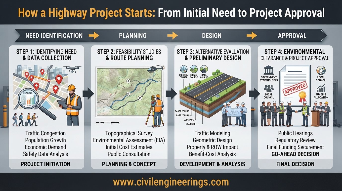
A highway does not begin with an excavator, asphalt plant, or pile of construction drawings. Long before construction equipment reaches the site, engineers, planners, government agencies, consultants, and communities must answer a much more fundamental question: Why is this highway needed, and what is the best way to develop it?
Understanding How a Highway Project Starts is essential for anyone involved in transportation infrastructure. A successful highway is the result of structured planning, feasibility studies, traffic analysis, route selection, surveys, environmental assessment, preliminary engineering, cost estimation, funding decisions, and approvals.
For civil engineering students, this process explains how classroom concepts become real infrastructure. For highway engineers and contractors, it shows where technical decisions originate and how early choices affect construction cost, schedule, safety, and long-term performance.
This guide follows a practical highway project development sequence—from identifying the transportation problem to defining the project, evaluating alternatives, selecting a corridor, conducting investigations, preparing preliminary designs, and obtaining approval for detailed design and construction.


The starting point of a highway project is usually a transportation need rather than a construction activity.
A road authority may discover that an existing route has severe congestion, poor safety performance, inadequate capacity, deteriorating pavement, unreliable travel times, or insufficient connectivity. A new industrial zone, housing development, port, airport, border crossing, or economic corridor may also create demand for a new highway.
In professional highway development, early planning normally identifies the problem, establishes the purpose and need, considers possible solutions, and defines the project scope. FHWA guidance similarly describes planning and scoping as early project-development activities involving needs, alternatives, impacts, and project scope. (Highways)
Typical Reasons for Starting a Highway Project
A highway project may originate because of:
- Increasing traffic congestion
- Rapid population growth
- Industrial or commercial development
- Poor road safety
- Insufficient highway capacity
- Deteriorated pavement
- Frequent flooding or drainage failures
- Missing links in the transportation network
- Development of a new economic corridor
- Rural areas requiring better accessibility
- Urban expansion
- Strategic or national connectivity requirements
- Disaster resilience requirements
- Need for bypasses around congested towns
The initial problem should be clearly defined before engineers start developing a preferred alignment.
The Difference Between a Need and a Project
A transportation need describes the problem.
A project describes a potential intervention.
For example:
Existing Highway A experiences severe congestion during peak hours because traffic demand has exceeded its practical capacity.
That is a problem statement.
Possible solutions might include:
- Improving intersections
- Adding lanes
- Constructing a bypass
- Upgrading public transportation
- Building a new parallel highway
- Improving traffic management
This distinction is important because the first solution considered is not necessarily the best solution.
Step 1: Identify the Transportation Problem
The first technical stage involves understanding what is actually happening within the transportation network.
Engineers and planners collect existing information about traffic, road conditions, accidents, land use, population, development patterns, and transportation demand.
Traffic and Capacity Assessment
Traffic studies help determine whether an existing route can accommodate present and future demand.
Important data may include:
- Average Annual Daily Traffic (AADT)
- Peak-hour traffic
- Directional distribution
- Vehicle classification
- Heavy commercial vehicles
- Origin-destination patterns
- Travel speed
- Travel time
- Intersection performance
- Queue lengths
- Crash history
A basic traffic-growth relationship can be expressed as:
Where:
- = traffic after years
- = current traffic
- = annual traffic growth rate
- = design period in years
For example, if current traffic is 20,000 vehicles/day, the assumed annual growth is 5%, and the planning horizon is 15 years:
The resulting forecast helps engineers understand whether existing infrastructure will remain adequate.
Safety Analysis
A project may start because a road has an unacceptable crash pattern.
Engineers review:
- Crash frequency
- Crash severity
- Black spots
- Junction conflicts
- Pedestrian incidents
- Road geometry
- Sight distance
- Speed characteristics
- Roadside hazards
Safety should not be treated as an issue that appears only during final design. It influences project justification and alternative evaluation from the beginning.
Step 2: Establish the Project Purpose and Need
Once the transportation problem is understood, the project team develops a clear purpose and need statement.
This becomes one of the most important foundations of the project.
What Is a Purpose and Need Statement?
The purpose explains what the project is intended to accomplish.
The need provides evidence showing why intervention is required.
For example:
Need: Traffic volumes between City A and City B have increased substantially, producing congestion, unreliable travel times, and increased crash exposure.
Purpose: Improve capacity, safety, travel reliability, and regional connectivity between the two cities.
A well-defined purpose prevents the project from drifting away from its original objectives.
Why Purpose and Need Matters
It helps engineers and decision-makers:
- Compare alternatives
- Establish project limits
- Define design objectives
- Evaluate environmental impacts
- Estimate benefits
- Prioritize funding
- Communicate with stakeholders
- Support approvals
FHWA describes project purpose and need as a key part of early project planning and scoping. (Highways)
Step 3: Conduct Preliminary Feasibility Studies
After establishing the need, the project team asks a practical question:
Can the proposed highway actually be built, and does it make economic and technical sense?
A feasibility study provides an early answer.
ICE describes feasibility work as involving both desktop investigation and site visits, with attention to access, constraints, existing infrastructure, and traffic-generating potential. (Institution of Civil Engineers (ICE))
Major Components of a Highway Feasibility Study
A highway feasibility study can examine:
- Traffic demand
- Route alternatives
- Terrain
- Geology
- Soil conditions
- Hydrology
- Drainage
- Existing utilities
- Land acquisition
- Environmental constraints
- Social impacts
- Construction requirements
- Bridge requirements
- Interchanges
- Pavement options
- Preliminary project cost
- Economic benefits
- Funding possibilities
- Construction risks
Preliminary Cost Estimate
At this stage, the estimate does not need the precision of a final engineer’s estimate.
A conceptual estimate might consider:
For major projects, risk allowances and escalation may also be considered.
The purpose is to determine whether the project is financially realistic and to compare alternatives on a common basis.
Step 4: Study the Corridor and Possible Highway Routes
Once the project appears feasible, engineers begin investigating where the highway should go.
This is one of the most influential decisions in highway engineering.


A highway alignment cannot simply connect two points using the shortest possible line. The selected corridor must respond to terrain, environmental conditions, settlements, existing infrastructure, drainage, soil, construction cost, safety, and future development.
Desktop Study
The first route investigation is often performed using available information such as:
- Topographic maps
- Satellite imagery
- Aerial photography
- Existing GIS data
- Geological maps
- Soil maps
- Flood maps
- Land-use information
- Existing transportation networks
- Utility records
- Property information
- Environmental databases
This process helps identify obvious constraints before expensive field investigations begin.
Reconnaissance Survey
Engineers then visit the potential corridor.
During reconnaissance, the team investigates:
- Mountainous areas
- Valleys
- Rivers
- Existing roads
- Railways
- Settlements
- Agricultural land
- Forests
- Flood-prone areas
- Utility corridors
- Potential bridge locations
- Construction access
- Borrow and disposal areas
The objective is to narrow a large study area into practical route alternatives.
Route Selection Principles
A good highway alignment should generally provide:
- Safe geometric characteristics
- Reasonable gradients
- Appropriate horizontal curves
- Suitable sight distance
- Economical earthwork
- Effective drainage
- Stable ground conditions
- Acceptable environmental impact
- Reasonable right-of-way requirements
- Good connectivity
- Appropriate access control
The cheapest initial construction option is not automatically the best alternative. Engineers should consider whole-life cost, including maintenance, user costs, safety, and operational performance.
Step 5: Perform Preliminary Surveys and Investigations
After promising corridors have been identified, engineering information becomes more detailed.
Topographic Survey
Survey teams collect ground elevations and physical features.
Modern highway surveys may use:
- Total stations
- GNSS/GPS
- Digital levels
- Drones
- LiDAR
- Photogrammetry
- GIS
- Digital terrain models
Survey information supports the development of:
- Existing-ground profiles
- Contour maps
- Cross-sections
- Drainage studies
- Preliminary horizontal alignment
- Preliminary vertical alignment
- Earthwork calculations
Geotechnical Investigation
A highway cannot be designed properly without understanding the ground beneath it.
Geotechnical investigations may include:
- Boreholes
- Trial pits
- Soil sampling
- Laboratory testing
- California Bearing Ratio (CBR)
- Grain-size analysis
- Atterberg limits
- Compaction testing
- Shear strength testing
- Groundwater investigation
The results influence pavement design, embankment stability, slope treatment, bridge foundations, retaining structures, and construction methods.
Hydrology and Drainage Investigation
Water is one of the major causes of highway deterioration.
Engineers investigate:
- Catchment areas
- Existing streams
- Flood levels
- Culvert locations
- Bridge crossings
- Surface runoff
- Groundwater
- Drainage outfalls
A simplified runoff relationship sometimes used during preliminary assessment is:
Where:
- = peak runoff
- = runoff coefficient
- = rainfall intensity
- = drainage area
The actual design method depends on the project, catchment size, local hydrology, applicable standards, and required level of analysis.
Step 6: Develop Alternative Highway Concepts
At this stage, engineers transform survey and planning information into possible engineering solutions.
Alternatives could involve differences in:
- Highway alignment
- Number of lanes
- Median configuration
- Interchange locations
- Bridge locations
- Pavement type
- Access-control strategy
- Service roads
- Grade-separated intersections
- Construction staging
The team then compares alternatives.
Multi-Criteria Alternative Evaluation
A practical evaluation matrix may consider:
| Criterion | Example Consideration |
|---|---|
| Traffic | Capacity and travel time |
| Safety | Crash risk and geometric quality |
| Cost | Construction and maintenance |
| Environment | Ecosystems, water, air and noise |
| ROW | Land acquisition requirements |
| Geotechnical | Ground and slope conditions |
| Drainage | Flood and water-management risks |
| Social | Community displacement and access |
| Construction | Complexity and duration |
| Future | Expansion and development potential |
This is where engineering judgment becomes extremely important.
FHWA’s alternatives-analysis guidance places alternative selection after the transportation need has been identified and before a final solution is established. (Highways)
Step 7: Select the Preferred Alternative
After technical studies, stakeholder input, environmental considerations, and economic evaluation, the project team identifies a preferred alternative.
The preferred route should provide a reasonable balance among:
Performance + Safety + Cost + Environment + Constructability + Community Impact
It is common for the preferred alternative to differ from the cheapest alternative.
For example, Route A may be 5 km shorter but require a major bridge and deep cuttings. Route B could be slightly longer but avoid difficult geology and reduce construction risk.
The correct engineering decision considers the complete project lifecycle rather than simply minimizing initial quantities.
Step 8: Environmental and Social Assessment
Highway projects can affect communities and natural systems.
Environmental investigations may consider:
- Wildlife
- Wetlands
- Water resources
- Vegetation
- Air quality
- Noise
- Cultural or archaeological resources
- Agricultural land
- Communities
- Resettlement
- Construction impacts
The specific legal process differs by country and funding source. In the United States, for example, environmental review under NEPA forms a significant part of project development. FHWA explains that environmental studies and documentation can occur during project scoping or preliminary design depending on the project and agency process. (Federal Highway Administration)
In Pakistan and other countries, engineers must follow the applicable national, provincial, environmental, land-acquisition, and highway-authority requirements.
Step 9: Define Right-of-Way and Utility Requirements
A technically excellent alignment can still face serious delays if land and utilities are not addressed early.
Right-of-Way Planning
The project team identifies:
- Required highway corridor
- Existing property boundaries
- Public land
- Private land
- Commercial properties
- Residential properties
- Agricultural areas
- Access requirements
Right-of-way requirements can significantly affect project cost.
Utility Coordination
Engineers identify existing:
- Water pipelines
- Gas pipelines
- Sewer networks
- Electricity transmission lines
- Distribution systems
- Fiber-optic cables
- Telecommunications infrastructure
Utility relocation should be investigated before finalizing construction plans.
FHWA identifies environmental, utility, and right-of-way coordination as important preliminary-engineering considerations. (FHWA Operations)
Step 10: Prepare the Preliminary Highway Design
Now the highway begins to take recognizable engineering form.
Preliminary design establishes the general geometry and major components.
Horizontal Alignment
Engineers determine:
- Tangent sections
- Circular curves
- Transition curves
- Curve radii
- Superelevation
- Sight distance
- Intersection locations
Vertical Alignment
The profile design includes:
- Gradients
- Vertical curves
- Crest curves
- Sag curves
- Elevation control
- Drainage considerations
Typical Cross-Section
A highway cross-section may include:
- Traffic lanes
- Median
- Shoulders
- Side slopes
- Drainage channels
- Kerbs
- Footpaths
- Cycle facilities
- Barriers
- Roadside safety zones
Design parameters depend on road classification, traffic, terrain, design speed, vehicle characteristics, and governing standards.
ICE notes that preliminary design helps determine where a road should be located within the preferred route envelope and includes topographical, environmental, and geographical surveys. (Institution of Civil Engineers (ICE))
Step 11: Estimate Quantities, Cost, and Project Schedule
Once the preliminary design becomes sufficiently developed, the project team can improve its cost estimate.
Typical quantities include:
- Clearing and grubbing
- Excavation
- Embankment
- Subgrade preparation
- Subbase
- Base course
- Asphalt or concrete pavement
- Drainage structures
- Culverts
- Bridges
- Retaining walls
- Guardrails
- Road signs
- Pavement markings
- Lighting
- Landscaping
A basic earthwork balance can be represented conceptually as:
The actual calculation requires cross-sectional areas, station intervals, material shrinkage/swell factors, haul distances, and suitability of excavated material.
For major projects, cost and schedule risk deserve early attention. FHWA’s major-project process specifically emphasizes accurate cost estimation, risk management, funding strategies, and defined project responsibilities. (Federal Highway Administration)
Step 12: Apply Highway Engineering Standards
A highway project should not be designed solely from personal engineering preference.
The project team should identify the applicable standards and design manuals at the beginning of the design process.
Depending on jurisdiction and contract requirements, references may include:
- AASHTO guidance
- IRC standards and guidelines
- ICE highway engineering guidance
- National highway authority manuals
- Local geometric design standards
- Pavement design procedures
- Bridge design codes
- Drainage standards
- Road safety standards
- Environmental regulations
AASHTO and IRC should be treated as technical references appropriate to the project’s jurisdiction and contractual requirements, rather than automatically applying one standard to every country.
ICE emphasizes that effective highway design depends on engineering principles, material properties, design loading, validated methods, and consideration of interaction between the road, ground, and environment. (Institution of Civil Engineers (ICE))
Step 13: Obtain Approvals and Secure Funding
Even an excellent engineering proposal cannot move to construction without the necessary approvals and financial arrangements.
Depending on the project, approvals may involve:
- Highway authority
- Planning authority
- Environmental authority
- Land-acquisition agency
- Utility agencies
- Local government
- Finance department
- Funding organization
- Public consultation bodies
Funding may come from:
- Government budgets
- Development programs
- Multilateral development banks
- Public-private partnerships
- Toll revenue
- Special infrastructure funds
- Provincial or local programs
The project may also need formal prioritization within a broader transportation program.
Step 14: Move From Preliminary Engineering to Detailed Design
After the project receives the necessary decisions and approvals, engineers progressively develop the preferred concept into construction-ready information.
Detailed design may include:
- Final horizontal alignment
- Final vertical profile
- Pavement design
- Drainage design
- Bridge design
- Culvert design
- Retaining structures
- Interchanges
- Traffic signs
- Pavement markings
- Roadside safety
- Lighting
- Utilities
- Traffic management
- Construction staging
- Bill of quantities
- Technical specifications
- Construction drawings
FHWA defines preliminary engineering broadly as location, design, and related work that prepares a project for physical construction. (Federal Highway Administration)
Step 15: Prepare Tender and Construction Documents
The final engineering package allows the owner to procure construction services.
Typical tender documentation includes:
- Drawings
- Specifications
- Bill of quantities
- Engineer’s estimate
- Contract conditions
- Technical requirements
- Construction schedule requirements
- Quality-control requirements
- Health and safety requirements
- Environmental requirements
ICE describes a broader road-development sequence as planning, design, tender, construction, maintenance, and operation, with design commonly divided into concept, preliminary, and detailed stages. (Institution of Civil Engineers (ICE))
Only after these stages are sufficiently advanced does the project transition into physical construction.
A Simple Highway Project Start-to-Construction Flow
The complete process can be simplified as:
Transportation Problem
↓
Needs Assessment
↓
Purpose and Need
↓
Feasibility Study
↓
Corridor Investigation
↓
Reconnaissance Survey
↓
Alternative Routes
↓
Traffic, Environmental & Geotechnical Studies
↓
Alternative Evaluation
↓
Preferred Route
↓
Preliminary Engineering
↓
ROW & Utility Planning
↓
Cost & Economic Evaluation
↓
Environmental and Regulatory Approval
↓
Funding & Project Authorization
↓
Detailed Design
↓
Tender/Procurement
↓
Construction
This sequence is a generalized framework. Actual project-development procedures vary by country, funding mechanism, highway authority, project size, procurement method, and environmental regulations.
Practical Recommendations for Civil Engineering Students
Students often think highway engineering begins with pavement thickness or alignment calculations. In professional practice, the process starts much earlier.
Focus on understanding the relationship between:
- Transportation planning
- Traffic engineering
- Highway classification
- Route location
- Surveying
- Geotechnical engineering
- Hydrology
- Pavement engineering
- Environmental assessment
- Cost estimation
- Construction management
When studying a highway project, ask:
What problem is this road solving?
That single question helps connect almost every later engineering decision.
Practical Recommendations for Highway Engineers
Experienced engineers should pay particular attention to early-stage risk.
Before committing to an alignment, verify:
- Traffic assumptions
- Survey control
- Terrain data
- Geotechnical conditions
- Hydrology
- Utility conflicts
- ROW constraints
- Environmental limitations
- Constructability
- Whole-life cost
Early investigation is generally cheaper than correcting an alignment, bridge location, drainage strategy, or land-acquisition problem after detailed design.
Preliminary engineering should therefore be treated as a decision-making stage—not merely as a preliminary drawing exercise.
Practical Recommendations for Contractors
Contractors may enter the project after many planning decisions have already been made, but understanding the project’s origin remains valuable.
During tender review, investigate:
- Existing ground conditions
- Earthwork quantities
- Borrow sources
- Disposal areas
- Material availability
- Traffic management requirements
- Utility relocation
- Access constraints
- Environmental restrictions
- Bridge and culvert construction
- Seasonal weather
- Construction sequence
A contractor who understands the original project constraints can often identify constructability risks that are not immediately obvious from drawings alone.
Common Mistakes When Starting a Highway Project
Several early mistakes can create expensive problems later.
Starting Design Before Defining the Problem
A technically impressive design can still be the wrong solution if the underlying transportation need is poorly understood.
Selecting the Shortest Route Automatically
The shortest alignment may involve difficult terrain, environmental damage, expensive structures, or excessive earthwork.
Underestimating Future Traffic
A highway designed around current traffic alone may become congested before its intended service life ends.
Ignoring Drainage During Route Selection
Drainage problems can influence construction cost, pavement durability, slope stability, and maintenance requirements.
Delaying Utility Investigation
Late utility conflicts can produce redesign, claims, construction delays, and additional costs.
Treating Cost as the Only Selection Criterion
A lower initial construction price does not necessarily mean lower lifecycle cost.
Inadequate Stakeholder Consultation
Communities, landowners, utility providers, environmental agencies, and road users can provide information that significantly affects project feasibility.
FAQs About How a Highway Project Starts
1. What is the first step in a highway project?
The first step is normally identifying and documenting a transportation need or problem. This may involve congestion, safety problems, inadequate capacity, poor connectivity, economic development, or deteriorated infrastructure.
2. Who decides whether a highway project should start?
Usually, the responsible transportation authority or project sponsor makes the decision, supported by planners, engineers, financial specialists, environmental professionals, and other stakeholders.
3. What is a highway feasibility study?
A feasibility study determines whether a proposed highway solution is technically, economically, environmentally, socially, and financially practical.
4. Why is route selection important in highway engineering?
Route selection affects construction quantities, land acquisition, bridges, drainage, environmental impacts, travel time, safety, maintenance, and total project cost. A poor alignment can create problems throughout the project’s life.
5. What surveys are required before highway construction?
Depending on project requirements, engineers may conduct topographic, traffic, geotechnical, geological, hydrological, environmental, utility, land, and route-location surveys.
6. What is the difference between preliminary and detailed highway design?
Preliminary design establishes the general route, geometry, major structures, and engineering concept. Detailed design develops the dimensions, drawings, specifications, quantities, and technical information required for construction.
7. When does pavement design begin?
Pavement design can begin during preliminary engineering when traffic loading, subgrade characteristics, climate, materials, and design requirements become sufficiently defined. It is then refined as investigation and design information improves.
8. Why is environmental assessment performed before highway construction?
Environmental assessment identifies potential effects on natural resources, communities, water, wildlife, cultural resources, air quality, noise, and land use so that impacts can be avoided, minimized, or mitigated.
9. What role does surveying play at the beginning of a highway project?
Surveying establishes accurate information about terrain, existing features, elevations, boundaries, and physical constraints. This information forms the basis for alignment, profile, drainage, earthwork, and design decisions.
10. Does every highway project follow exactly the same process?
No. The general sequence is similar, but actual procedures depend on the country’s regulations, highway authority, project size, funding source, procurement method, environmental requirements, and project complexity.
Conclusion: How a Highway Project Starts
Understanding How a Highway Project Starts reveals why highway construction is much more than placing pavement on prepared ground. The physical road is actually the final result of a long chain of planning and engineering decisions.
A project typically begins with a transportation problem or development need. Engineers and planners then establish the purpose and need, investigate feasibility, study potential corridors, perform traffic and field surveys, evaluate environmental and geotechnical constraints, compare alternative alignments, and select a preferred solution. Preliminary engineering follows, supported by cost estimation, right-of-way planning, utility coordination, environmental approvals, funding, and risk assessment.
Only after these decisions mature does the project move toward detailed design, tendering, and construction.
For students, the key lesson is to understand the complete project lifecycle. Engineers and consultants, careful early investigation is one of the best ways to control cost and risk. For contractors, understanding the decisions behind the design helps reveal constructability challenges before they become claims or delays.
A well-built highway starts with a well-defined problem, reliable data, sound engineering judgment, and disciplined project planning.
