
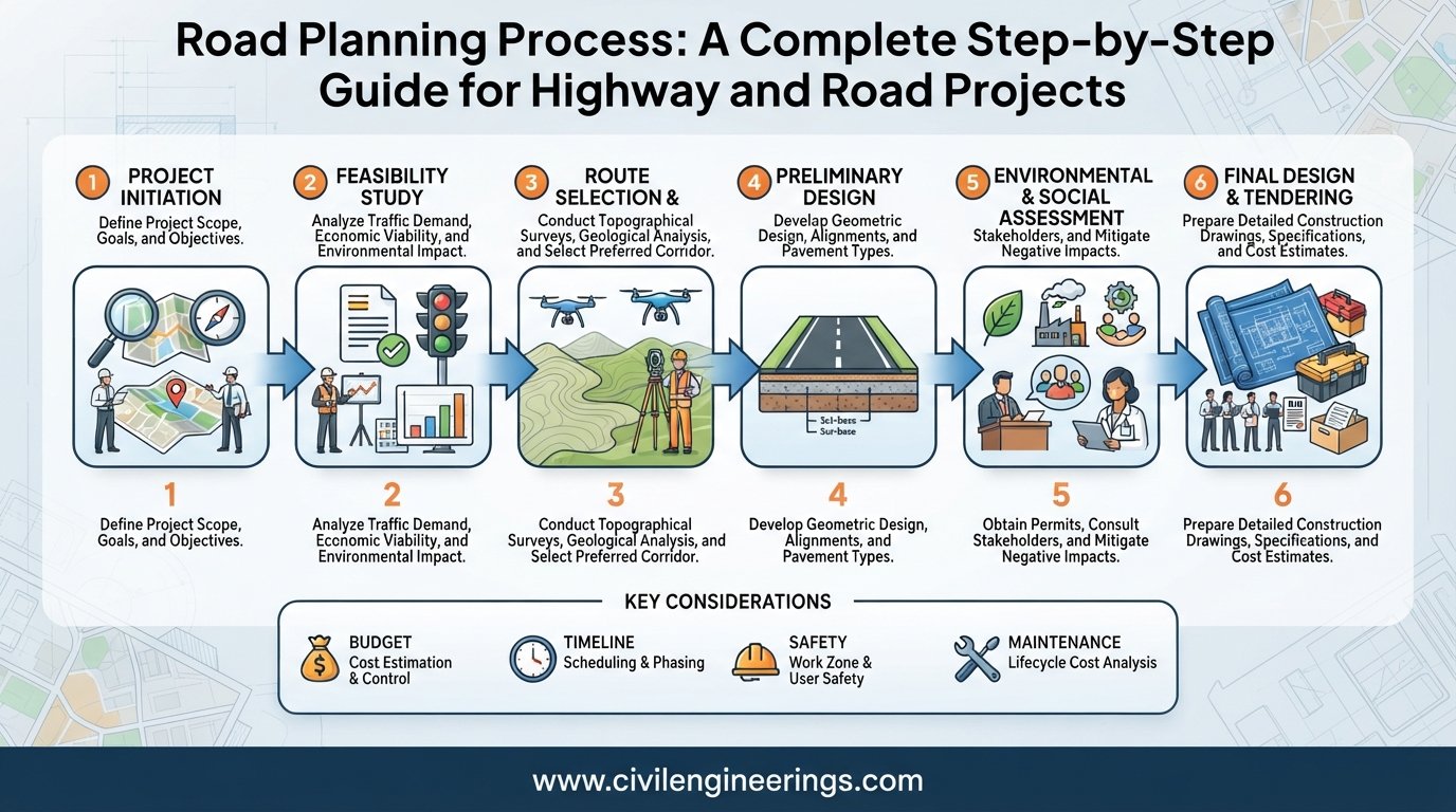
Roads do not become successful infrastructure projects simply because a pavement is designed and constructed correctly. The real success begins much earlier, with a systematic Road Planning Process that identifies the need, evaluates alternatives, considers traffic and terrain, controls costs, protects communities and the environment, and establishes a practical construction strategy.
Poor planning can lead to unnecessary land acquisition, excessive construction costs, traffic congestion, drainage failures, safety problems, and expensive redesigns. Good planning, on the other hand, creates a clear connection between transportation demand, engineering design, available funding, environmental requirements, and long-term maintenance.
For civil engineering students and practicing highway professionals, understanding road planning means looking beyond pavement layers. It involves route selection, traffic forecasting, surveys, feasibility studies, geometric considerations, right-of-way planning, economic evaluation, environmental assessment, and project documentation.
This guide explains the Road Planning Process from the initial identification of a transportation need through feasibility, route selection, preliminary design, approvals, detailed planning, and preparation for construction. It also covers engineering principles, practical examples, standards, common mistakes, and recommendations for students, engineers, and contractors.
What Is the Road Planning Process?
The Road Planning Process is the systematic sequence of technical, economic, environmental, social, and administrative activities used to determine whether a road should be built, where it should be located, what standards it should follow, and how it should be developed.
A road planner does not begin by drawing an alignment on a map. The process normally starts with a transportation problem or development requirement.
For example, a growing industrial area may require a new access highway. An existing urban corridor may need widening because traffic demand has exceeded its capacity. A rural community may require an all-weather road to connect agricultural production with markets.
The planning process converts that need into an implementable infrastructure project.
A typical sequence is:
Need Identification → Data Collection → Traffic Study → Feasibility Study → Route Selection → Preliminary Engineering → Environmental and Social Assessment → Economic Evaluation → Right-of-Way Planning → Detailed Design → Approvals → Construction Planning
The exact sequence varies according to project size, funding arrangements, terrain, jurisdiction, and applicable standards.
Why Road Planning Is Important
Road planning determines many decisions that later become difficult or expensive to change.
A pavement thickness can sometimes be redesigned. Changing the fundamental highway corridor after land acquisition or construction has started can be extremely costly.
Effective planning helps achieve several objectives:
- Improve transportation connectivity
- Reduce travel time and vehicle operating costs
- Select an economical route
- Improve road safety
- Minimize environmental impacts
- Coordinate utilities and drainage
- Estimate realistic project costs
- Protect the required right of way
- Establish appropriate design standards
- Plan future traffic capacity
- Reduce construction and maintenance risks
Road planning also supports regional development. A well-selected highway can improve access to employment, education, healthcare, markets, ports, airports, and industrial zones.
For government agencies and infrastructure developers, planning provides the technical justification needed for investment decisions.
Major Stages of the Road Planning Process
1. Identify the Transportation Need
Every road project begins with a clearly defined transportation problem or development objective.
The need may arise from:
- Increasing traffic congestion
- Population growth
- New housing developments
- Industrial expansion
- Agricultural development
- Poor existing road conditions
- Missing links in the transportation network
- Safety deficiencies
- Disaster resilience requirements
- Strategic or regional connectivity
At this stage, planners should define the problem rather than immediately assume the solution.
For example, severe congestion does not automatically mean that a new highway is required. Widening, intersection improvement, public transportation, traffic management, or bypass construction may provide better solutions.
2. Collect Existing Data
Reliable planning depends on reliable information.
Engineers collect available data related to the proposed corridor and surrounding area. Important sources include existing maps, satellite imagery, traffic records, census information, land-use plans, geological information, hydrological records, and previous feasibility studies.
Field investigations may include:
- Existing road inventory
- Traffic counts
- Origin-destination surveys
- Topographic surveys
- Soil investigations
- Drainage observations
- Utility mapping
- Property information
- Accident records
- Environmental observations
Data should be checked for accuracy and consistency before engineers use it in design decisions.
3. Conduct Traffic Studies
Traffic demand is one of the most important inputs in highway planning.
Engineers determine existing traffic volume and estimate future demand. Traffic studies commonly examine passenger cars, buses, trucks, motorcycles, and other vehicle classes.
Important traffic parameters include:
- Average Daily Traffic (ADT)
- Annual Average Daily Traffic (AADT)
- Peak-hour traffic
- Directional distribution
- Vehicle classification
- Traffic growth rate
- Origin-destination patterns
- Axle loading
- Future development traffic
A basic future traffic estimate can be expressed as:
Future Traffic = Present Traffic × (1 + g)ⁿ
Where:
- g = annual traffic growth rate
- n = number of years in the design period
For example, if current traffic is 10,000 vehicles/day, annual growth is 5%, and the planning horizon is 10 years:
Future Traffic = 10,000 × (1.05)¹⁰
This produces approximately 16,289 vehicles/day.
In professional projects, traffic forecasting can involve much more sophisticated transportation models, especially for major urban highways.
4. Develop Planning Alternatives
Good road planning rarely depends on one proposed solution.
Engineers develop several alternatives and compare them technically and economically.
Possible alternatives may include:
- New road construction
- Existing road widening
- Bypass construction
- Realignment
- Intersection improvement
- Service roads
- Grade-separated intersections
- Bridge or tunnel options
- Traffic management improvements
Each alternative should be evaluated using consistent criteria.
Typical evaluation factors include:
| Factor | Planning Consideration |
|---|---|
| Traffic | Capacity and future demand |
| Terrain | Mountains, valleys, rivers and slopes |
| Cost | Construction and land costs |
| Safety | Crash risk and geometric suitability |
| Environment | Sensitive areas and natural resources |
| Land | Right-of-way and property impacts |
| Utilities | Relocation requirements |
| Drainage | Flooding and water crossings |
| Development | Existing and future land use |
| Maintenance | Long-term operational requirements |
The cheapest route is not necessarily the best route.
5. Perform a Feasibility Study
A feasibility study determines whether the proposed project is technically, economically, environmentally, and financially practical.
A highway feasibility study generally investigates:
- Project objectives
- Traffic demand
- Preliminary alignment
- Terrain
- Geotechnical conditions
- Hydrology
- Preliminary structures
- Construction requirements
- Land acquisition
- Environmental constraints
- Preliminary cost
- Economic benefits
- Risks
- Implementation schedule
The feasibility stage is particularly important for large infrastructure projects because it prevents major investments from proceeding without adequate justification.
6. Select the Highway Corridor
Corridor selection is one of the most influential decisions in road development.
The corridor should provide a practical connection between important origins and destinations while avoiding unnecessary engineering difficulties.
Engineers consider:
- Terrain
- Existing settlements
- Rivers and water bodies
- Geological hazards
- Agricultural land
- Forests and protected areas
- Archaeological sites
- Existing transportation corridors
- Utility networks
- Future development
- Construction accessibility
For mountainous terrain, a route with slightly greater length may be preferable if it significantly reduces excessive gradients, earthwork, retaining structures, and landslide risks.
The best corridor is therefore a balance between engineering performance, cost, safety, environmental responsibility, and social impact.
7. Carry Out Route and Topographic Surveys
Once a preferred corridor has been identified, detailed field surveys provide the physical information required for preliminary engineering.
A topographic survey may establish:
- Ground elevations
- Contours
- Existing roads
- Buildings
- Drainage channels
- Rivers
- Utility lines
- Property boundaries
- Vegetation
- Structures
- Other physical features
Modern road projects may use GNSS/GPS surveying, total stations, drones, LiDAR, digital terrain models, and GIS.
The resulting survey data forms the basis for alignment development and preliminary highway geometry.
8. Investigate Soil and Geotechnical Conditions
A road cannot be planned properly without understanding the ground beneath it.
Geotechnical investigations help identify:
- Soil classification
- Bearing capacity
- Subgrade strength
- Groundwater conditions
- Expansive soils
- Soft soils
- Rock formations
- Landslide-prone areas
- Settlement risks
Common field and laboratory investigations may include boreholes, trial pits, Standard Penetration Tests, California Bearing Ratio testing, grain-size analysis, Atterberg limits, compaction testing, and laboratory strength tests.
The findings influence earthwork, pavement design, slope protection, retaining structures, drainage, and foundation design.
9. Plan the Preliminary Highway Geometry
After collecting topographic and geotechnical information, engineers develop a preliminary road alignment.
Highway geometry normally includes:
- Horizontal alignment
- Vertical alignment
- Carriageway width
- Lane arrangement
- Shoulders
- Median
- Superelevation
- Sight distance
- Junction spacing
- Grade
- Cross-section elements
Horizontal curves should provide safe and comfortable vehicle movement.
A basic relationship commonly used in highway geometric design is:
e + f = V² / (127R)
Where:
- e = superelevation rate
- f = side friction factor
- V = speed in km/h
- R = curve radius in metres
The actual design criteria depend on the governing highway standard and project conditions.
10. Develop the Drainage and Water Management Plan
Drainage deserves attention during planning, not after pavement construction.
Water is one of the major causes of premature road deterioration. Poor drainage can weaken the subgrade, erode embankments, damage pavement layers, and create dangerous driving conditions.
Road drainage planning may include:
- Side drains
- Cross-drainage structures
- Culverts
- Catch drains
- Median drainage
- Subsurface drainage
- Bridges
- Inlets and outlets
- Scour protection
- Flood mitigation
Hydrological investigations determine design flows for drainage structures.
A simplified rational method for small catchments is:
Q = CIA
Where:
- Q = peak runoff
- C = runoff coefficient
- I = rainfall intensity
- A = drainage area
Engineers must use appropriate units and jurisdiction-specific hydrological procedures.
11. Conduct Environmental and Social Assessment
Modern road planning must consider more than engineering and cost.
A highway can affect communities, agricultural land, ecosystems, water resources, noise levels, air quality, and cultural heritage.
Environmental and social assessment may examine:
- Land acquisition
- Resettlement
- Noise
- Air quality
- Watercourses
- Wildlife
- Vegetation
- Wetlands
- Cultural heritage
- Community access
- Construction impacts
- Occupational and public safety
The objective is not necessarily to eliminate every impact. It is to identify impacts early and develop effective avoidance, mitigation, and management measures.
12. Carry Out Economic and Financial Evaluation
A major road investment should demonstrate reasonable value relative to its cost.
Economic evaluation can consider benefits such as:
- Travel-time savings
- Vehicle operating cost savings
- Accident reduction
- Improved accessibility
- Freight efficiency
- Regional economic development
A simplified benefit-cost ratio is:
BCR = Present Value of Benefits / Present Value of Costs
If the ratio exceeds 1, the project may generate benefits greater than its evaluated costs, although investment decisions require broader financial, social, strategic, and policy considerations.
Other indicators can include:
- Net Present Value
- Internal Rate of Return
- Economic Rate of Return
- Payback considerations
For public infrastructure, economic appraisal should consider the full life cycle rather than construction cost alone.
13. Plan Right of Way and Land Acquisition
The road corridor must have enough land for the planned infrastructure and, where required, future expansion.
Right-of-way planning may accommodate:
- Carriageway
- Shoulders
- Drainage
- Slopes
- Medians
- Service roads
- Interchanges
- Utilities
- Future widening
- Maintenance access
Land acquisition can become one of the most significant causes of highway project delays.
Engineers should therefore coordinate early with land, legal, utility, and social teams.
14. Select Appropriate Design Standards
Road planning must establish the standards that will govern the project.
Depending on location and project requirements, engineers may consult standards and guidance from organizations such as:
- IRC — Indian Roads Congress
- AASHTO — American Association of State Highway and Transportation Officials
- ICE — Institution of Civil Engineers
- National highway authorities
- Local road agencies
- Applicable environmental and construction regulations
These references may provide guidance for geometric design, pavement design, traffic engineering, structures, materials, drainage, safety, and project management.
Engineers should always confirm the latest edition and the legally applicable standards for the specific jurisdiction.
15. Prepare Preliminary Cost Estimates
Cost estimation during planning allows decision-makers to compare alternatives before committing to detailed design.
Preliminary costs can include:
- Land acquisition
- Earthwork
- Pavement
- Bridges
- Culverts
- Drainage
- Retaining structures
- Intersections
- Utilities
- Traffic facilities
- Road safety features
- Environmental mitigation
- Engineering services
- Construction supervision
- Contingencies
A useful conceptual approach is:
Total Project Cost = Direct Construction Cost + Land Cost + Engineering Cost + Utility Costs + Environmental Costs + Contingency
The level of accuracy should increase as the project moves from concept to detailed design.
16. Develop the Detailed Road Design
After the preferred alternative receives appropriate approval, engineers progress to detailed design.
Detailed highway design can include:
- Final horizontal alignment
- Vertical profile
- Typical cross-sections
- Pavement design
- Earthwork quantities
- Drainage design
- Culvert design
- Bridge coordination
- Intersection design
- Roadside safety
- Signs and markings
- Lighting
- Guardrails
- Utility coordination
- Landscaping
- Construction details
At this stage, the road becomes a coordinated engineering package rather than simply a line on a map.
17. Coordinate Utilities and Other Infrastructure
Existing utilities can cause major construction problems if planners ignore them.
Possible conflicts include:
- Water pipelines
- Gas lines
- Electrical transmission
- Distribution networks
- Telecommunications
- Sewer systems
- Irrigation channels
Utility surveys and coordination should occur before construction begins.
A practical utility management plan identifies the utility owner, exact location, required protection or relocation, responsibility, cost, and expected completion date.
18. Prepare Construction and Implementation Plans
Planning continues beyond design.
The implementation strategy should address:
- Construction sequencing
- Traffic management
- Temporary access
- Material sources
- Equipment requirements
- Construction camps
- Quality control
- Safety management
- Environmental management
- Work zones
- Procurement
- Contract packaging
- Construction schedule
For an existing highway, maintaining traffic during construction becomes a major planning issue.
Temporary diversions, lane closures, pedestrian access, emergency routes, and work-zone safety must be considered before mobilization.
19. Establish Quality, Safety, and Risk Controls
A professional road planning process identifies project risks early.
Common risks include:
- Uncertain ground conditions
- Land acquisition delays
- Utility conflicts
- Flooding
- Material shortages
- Price escalation
- Traffic growth exceeding forecasts
- Environmental objections
- Contractor capacity
- Extreme weather
- Design changes
A risk register can rank each risk according to probability and potential impact.
Safety should also be incorporated into planning through appropriate road hierarchy, access control, intersection spacing, sight distance, pedestrian facilities, roadside design, and traffic management.
20. Monitor the Project Against the Original Plan
Road planning does not end when construction starts.
Engineers should compare actual project performance against the approved plan.
Important indicators include:
- Cost performance
- Schedule performance
- Traffic assumptions
- Land acquisition progress
- Design changes
- Material availability
- Safety performance
- Environmental compliance
- Quality performance
Lessons learned from construction should also feed into future road projects.
Road Planning Process Flow Diagram
A simplified road planning workflow can be represented as:
Transportation Need
↓
Existing Data Collection
↓
Traffic & Demand Forecasting
↓
Alternative Development
↓
Feasibility Study
↓
Corridor Selection
↓
Survey & Investigation
↓
Preliminary Engineering
↓
Environmental & Social Assessment
↓
Economic Evaluation
↓
ROW & Utility Planning
↓
Detailed Design
↓
Approvals & Procurement
↓
Construction Planning
↓
Construction & Quality Control
↓
Operation, Maintenance & Performance Monitoring
This sequence may overlap in real projects. For example, environmental investigations and land acquisition planning often continue while engineering design develops.
Practical Example of Road Planning
Consider a proposed 25 km highway connecting a growing industrial zone to an existing national highway.
Traffic surveys show approximately 8,000 vehicles/day currently use the existing access route. Forecasting indicates that industrial development could increase demand substantially over the planning period.
Three alternatives are developed:
- Alternative A follows the shortest route but crosses several settlements.
- Alternative B is longer but requires less land acquisition and avoids major flood-prone areas.
- Alternative C uses part of an existing corridor but requires substantial widening and utility relocation.
A proper evaluation would compare all three alternatives rather than automatically selecting the shortest route.
The final decision could favor Alternative B if its additional construction length is offset by lower social impacts, better flood resilience, safer geometry, fewer property conflicts, and lower long-term maintenance requirements.
This illustrates an important principle:
Road planning optimizes the complete project, not simply the shortest alignment or lowest initial construction cost.
Best Practices for Effective Road Planning
Experienced highway teams commonly apply several practical principles.
Use Reliable Field Data
Do not depend exclusively on old maps or assumptions. Verify important conditions in the field.
Plan Drainage Early
A beautiful alignment can still become a failed road if hydrology and drainage receive inadequate attention.
Consider Future Development
Land-use changes can dramatically alter traffic demand. Coordinate road planning with regional and urban development plans.
Compare Alternatives Objectively
Use measurable technical, environmental, economic, and social criteria.
Integrate Road Safety
Safety should influence alignment, intersections, access control, pedestrian facilities, roadside features, and work-zone planning.
Protect Future Right of Way
Where justified, planning should consider future widening and transportation demand.
Coordinate Disciplines
Highway planning requires collaboration between surveyors, traffic engineers, geotechnical engineers, hydrologists, environmental specialists, structural engineers, utility experts, economists, and project managers.
Recommendations for Civil Engineering Students
Students should learn to think of road planning as a complete system rather than only a geometric-design exercise.
Focus on understanding:
- Traffic surveys
- Highway classification
- Route selection
- Topographic surveying
- Soil investigation
- Geometric design
- Pavement engineering
- Drainage
- Cost estimation
- GIS and CAD
- Road safety
- Environmental considerations
When studying a proposed highway, try to answer one question:
Why was this road planned in this location and to this standard?
That question develops engineering judgment.
Recommendations for Highway Engineers and Consultants
Engineers should maintain clear assumptions and document the reasoning behind major planning decisions.
Important recommendations include:
- Validate traffic forecasts against actual field conditions.
- Review terrain and drainage before fixing the corridor.
- Coordinate geotechnical investigations with alignment development.
- Assess utility conflicts during preliminary planning.
- Use life-cycle thinking instead of focusing only on initial construction cost.
- Document alternatives that were rejected and explain why.
- Apply current and jurisdictionally appropriate design standards.
- Include resilience against flooding, extreme weather, and other foreseeable hazards.
Good documentation protects both the project and the engineering team.
Recommendations for Contractors
Although contractors usually enter after planning and design, understanding the planning basis improves project execution.
Contractors should carefully review:
- Design assumptions
- Site constraints
- Existing utilities
- Material sources
- Temporary traffic arrangements
- Drainage requirements
- Construction access
- Right-of-way limits
- Environmental conditions
- Construction sequencing
Early identification of discrepancies can reduce claims, delays, rework, and safety incidents.
Common Mistakes in Road Planning
Several mistakes repeatedly create problems in highway projects.
Selecting a Route Based Only on Distance
The shortest alignment may produce excessive earthwork, expensive structures, difficult curves, or major social impacts.
Ignoring Future Traffic
Designing only for today’s traffic can cause premature capacity problems.
Treating Drainage as a Secondary Issue
Water-related failures can undermine otherwise well-designed pavement.
Delaying Utility Investigation
Unknown pipelines and cables can disrupt construction schedules.
Underestimating Land Acquisition
A technically excellent alignment can become impractical if property acquisition is politically, legally, or socially difficult.
Using Inappropriate Standards
Standards should match the project’s road class, operating conditions, jurisdiction, and design objectives.
Failing to Document Assumptions
Unrecorded assumptions become difficult to verify when project conditions change.
Role of Technology in Modern Road Planning
Technology has significantly changed highway planning.
GIS allows engineers to combine layers such as terrain, land use, drainage, geology, population, utilities, and environmental constraints.
Drone surveys can rapidly capture corridor information, while LiDAR can generate detailed terrain models.
Building Information Modeling and digital engineering workflows can improve coordination between road geometry, drainage, structures, utilities, and construction information.
Traffic simulation and forecasting tools can help planners understand congestion and network performance.
Artificial intelligence and machine learning are also emerging in areas such as traffic prediction, pavement condition assessment, route optimization, and risk analysis. However, engineering judgment and verification remain essential.
FAQs About the Road Planning Process
What is the first step in the Road Planning Process?
The first step is normally identifying and defining the transportation need or problem. Engineers then determine whether a new road, improvement, bypass, widening, or another transportation solution is appropriate.
How long does road planning take?
The duration varies considerably. A small road improvement may require limited planning, while a major highway corridor can require several years of surveys, feasibility studies, environmental approvals, land acquisition, design, and procurement.
Why is traffic forecasting important in road planning?
Traffic forecasting helps determine future demand, road capacity, lane requirements, intersection performance, pavement loading, and the need for future expansion.
What factors influence highway route selection?
Important factors include terrain, traffic demand, soil conditions, drainage, environmental constraints, settlements, land acquisition, utilities, construction cost, safety, and future development.
Which standards are used for road planning?
Standards depend on the project location and governing authority. Engineers may use applicable national road standards along with references and guidance from organizations such as IRC, AASHTO, and ICE.
Is road planning the same as road design?
No. Planning determines the need, corridor, alternatives, feasibility, standards, and overall project strategy. Detailed design develops the precise geometry, pavement, drainage, structures, safety features, and construction details.
Why is drainage considered during road planning?
Drainage influences alignment, elevation, culvert requirements, flood risk, slope stability, pavement performance, and long-term maintenance. Early drainage planning can prevent expensive modifications later.
What is the role of GIS in road planning?
GIS helps engineers analyze spatial information and compare possible corridors using terrain, land use, environmental constraints, population, utilities, hydrology, and other geographic data.
Why is right-of-way important?
Adequate right of way provides space for the roadway, drainage, slopes, utilities, safety features, maintenance, and potentially future widening. Insufficient ROW can create serious construction and expansion problems.
What makes a good road planning process?
A good process uses reliable data, compares realistic alternatives, integrates traffic, geometry, geotechnical, drainage, environmental, economic, social, and safety considerations, and clearly documents decisions.
Conclusion
The Road Planning Process is the foundation on which successful highway infrastructure is built. It begins with identifying a genuine transportation need and continues through data collection, traffic forecasting, feasibility analysis, corridor selection, surveys, geotechnical investigation, preliminary engineering, environmental assessment, economic evaluation, right-of-way planning, detailed design, and construction preparation.
The strongest road projects do not simply minimize initial construction cost. They balance safety, mobility, environmental responsibility, social impacts, constructability, resilience, maintenance requirements, and life-cycle value.
For students, understanding this process develops engineering judgment. Highway engineers and consultants, it provides a structured basis for technical decisions. For contractors, it clarifies the assumptions and constraints that influence construction.
Modern tools such as GIS, drones, digital terrain models, traffic modeling, and digital engineering can make planning more efficient. Nevertheless, technology cannot replace sound engineering judgment and reliable field verification.
Ultimately, effective road planning connects transportation demand with practical engineering, responsible investment, and long-term infrastructure performance.
