
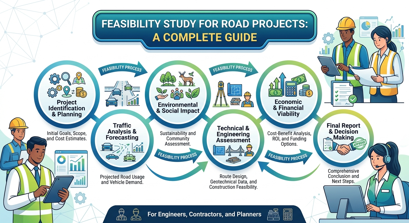
A road may look like a simple strip of pavement connecting two locations, but planning one successfully requires much more than selecting an alignment and estimating construction quantities. Before significant money is committed, engineers and decision-makers need to establish whether the proposed road can be built, financed, operated, maintained, and justified over its intended life. This is where a Feasibility Study for Road Projects becomes essential.
A properly prepared feasibility study examines transportation demand, route alternatives, traffic conditions, topography, geology, drainage, pavement requirements, environmental constraints, land acquisition, construction costs, economic benefits, risks, and long-term maintenance. It converts an initial infrastructure idea into evidence that can support an investment decision.
For highway engineers, consultants, government agencies, contractors, and civil engineering students, understanding this process is valuable because mistakes made during feasibility can become expensive problems during detailed design or construction. This guide explains the complete road-project feasibility process, from project identification and data collection to alternative evaluation, economic analysis, risk assessment, and final recommendations.
What Is a Feasibility Study for Road Projects?
A Feasibility Study for Road Projects is a systematic engineering, economic, environmental, and financial investigation used to determine whether a proposed road or highway project is practical and worth pursuing.

The study does not normally replace detailed design. Instead, it provides enough reliable information to answer a fundamental question:
Should the project proceed, be modified, postponed, or rejected?
FHWA describes a feasibility study as a project- or corridor-specific investigation that provides preliminary information about a potential transportation improvement, including alternative costs and potential problems or impacts before detailed analysis.
A road feasibility study therefore acts as a decision-making bridge between the initial project concept and subsequent stages such as preliminary engineering, environmental assessment, land acquisition, detailed design, procurement, and construction.
Main Objectives of a Road Feasibility Study
Typical objectives include:

- Establishing the transportation need.
- Defining project objectives and constraints.
- Identifying practical route alternatives.
- Forecasting present and future traffic demand.
- Assessing terrain, geology, drainage, and soil conditions.
- Evaluating environmental and social impacts.
- Estimating construction and lifecycle costs.
- Assessing economic benefits.
- Identifying land acquisition and utility requirements.
- Evaluating project risks.
- Determining potential financing options.
- Selecting a preferred alternative.
- Establishing whether further design and investigation are justified.
The study should provide evidence rather than simply support a predetermined route.
Why Is a Feasibility Study Important in Road Engineering?
Road projects involve large capital investments and affect communities, businesses, landowners, natural resources, and transportation networks for decades.
A feasibility study helps identify problems before they become expensive.
For example, a proposed highway may appear attractive on a satellite map but encounter steep terrain, unstable slopes, flood-prone areas, protected environmental resources, major utility corridors, or extensive property acquisition once investigated on the ground.
Early investigation allows engineers to compare alternatives while changes are still relatively inexpensive.
FHWA also emphasizes that transportation economic analysis should be coordinated with planning, engineering, environmental review, and policy considerations rather than treated as an isolated calculation.
Key Benefits
A well-executed study can:
- Reduce the risk of investing in an unsuitable project.
- Identify technically difficult sections early.
- Compare alternative alignments objectively.
- Improve preliminary cost estimates.
- Support funding and financing decisions.
- Identify environmental constraints.
- Establish realistic construction schedules.
- Improve stakeholder communication.
- Support future environmental and design work.
- Provide a defensible basis for project approval.
The value becomes even greater for major highways where a poor early decision can affect thousands of road users and create significant cost escalation.
Major Components of a Road Project Feasibility Study
A comprehensive feasibility study normally combines several technical disciplines. No single investigation can determine feasibility on its own.
Project Need and Problem Definition
The first step is understanding why the project is being considered.
The existing problem may involve:
- Traffic congestion.
- Poor road safety.
- Insufficient road capacity.
- Weak pavement.
- Missing connectivity.
- Freight delays.
- Poor access to markets.
- Urban development.
- Rural accessibility.
- Disaster resilience.
- Economic development.
- Deficient bridges or intersections.
A project should have a clear purpose and need. FHWA planning guidance similarly emphasizes defining project purpose, need, study area, evaluation criteria, and alternatives before progressing through environmental review and project development.
Traffic and Transportation Analysis
Traffic demand is one of the most important technical inputs.
Engineers generally investigate:
- Existing Average Annual Daily Traffic (AADT).
- Peak-hour traffic.
- Vehicle classification.
- Heavy commercial vehicles.
- Origin-destination patterns.
- Travel speeds.
- Intersection turning movements.
- Pedestrian and bicycle movements.
- Public transport.
- Seasonal traffic variation.
- Future development.
- Freight movements.
Traffic forecasting then estimates future demand over the design period.
A simplified traffic growth relationship can be expressed as:
Future Traffic = Present Traffic × (1 + g)ⁿ
Where:
- g = annual traffic growth rate
- n = number of years in the forecast period
For example, if current traffic is 20,000 vehicles/day, annual growth is 4%, and the forecast period is 20 years:
Future Traffic = 20,000 × (1.04)²⁰
This gives approximately 43,822 vehicles/day.
In a professional study, however, traffic forecasting should not depend only on a simple growth factor. Land-use changes, induced travel, economic activity, network changes, freight demand, and competing transport modes may significantly influence future traffic.
Route and Corridor Assessment
The corridor investigation examines where the road could realistically be constructed.
Engineers consider:
- Terrain.
- Existing roads.
- Rivers and drainage channels.
- Settlements.
- Agricultural land.
- Forests.
- Protected areas.
- Railways.
- Utility corridors.
- Existing development.
- Property boundaries.
- Geological conditions.
- Floodplains.
- Major structures.
A corridor that is shorter in distance may not be the cheapest or safest option.
For instance, a 40 km alignment through difficult mountainous terrain could cost substantially more than a 45 km alignment following more favorable ground conditions.
Topographical Survey
Topographic information establishes the physical characteristics of the proposed corridor.
Typical data includes:
- Ground elevations.
- Contours.
- Existing roads.
- Buildings.
- Drainage features.
- Rivers.
- Trees.
- Utility poles.
- Property boundaries.
- Bridges and culverts.
- Other physical features.
Modern projects may combine conventional total-station surveys, GNSS, aerial photogrammetry, LiDAR, and drone surveys.
The level of survey should match the project stage. A feasibility study does not normally require the same survey density as final construction drawings.
Geotechnical and Geological Investigation
Ground conditions can make or break a road project.
Preliminary geotechnical investigation should consider:
- Soil classification.
- Bearing capacity.
- Subgrade strength.
- Groundwater.
- Rock conditions.
- Expansive soils.
- Collapsible soils.
- Landslide potential.
- Settlement.
- Faults and seismic conditions where relevant.
- Borrow material availability.
For pavement feasibility, preliminary subgrade information may include CBR testing or other appropriate strength indicators.
If a proposed alignment crosses weak alluvial deposits, marshy ground, expansive clay, or unstable slopes, the project may require expensive ground improvement, retaining structures, deep drainage, or route modification.
Environmental and Social Feasibility
A technically attractive road can still become impractical because of environmental or social impacts.
Environmental screening should identify potentially sensitive resources before a preferred corridor becomes fixed.
Typical considerations include:
- Wetlands.
- Rivers and water bodies.
- Wildlife habitats.
- Forests.
- Protected areas.
- Cultural heritage.
- Archaeological sites.
- Air quality.
- Noise.
- Soil erosion.
- Water pollution.
- Landscape impacts.
- Community severance.
Social considerations may include:
- Land acquisition.
- Resettlement.
- Business displacement.
- Access to properties.
- Effects on agricultural land.
- Community connectivity.
- Pedestrian safety.
- Vulnerable road users.
The exact statutory requirements depend on the country and funding mechanism. For example, projects receiving U.S. federal support may involve the NEPA environmental review framework, while other countries apply their own environmental legislation.
The important engineering principle is universal: environmental and social constraints should influence route selection early, not after the alignment has already been finalized.
Road Design and Engineering Feasibility
The engineering team must establish whether the proposed road can meet appropriate design requirements.
Geometric Design
Preliminary geometric design normally examines:
- Design speed.
- Horizontal alignment.
- Vertical alignment.
- Sight distance.
- Superelevation.
- Lane widths.
- Shoulder widths.
- Medians.
- Intersections.
- Interchanges.
- Access control.
- Pedestrian facilities.
The designer should verify that alternatives can satisfy the applicable road design standards without excessive earthworks or unsafe geometry.
Pavement Feasibility
The pavement investigation considers:
- Traffic loading.
- Subgrade conditions.
- Climate.
- Drainage.
- Material availability.
- Maintenance strategy.
- Construction capability.
Possible pavement systems include flexible pavement, rigid pavement, and other engineered pavement solutions.
At feasibility stage, the objective is generally to establish a reasonable pavement concept and cost range rather than complete final pavement thickness calculations.
Drainage and Hydraulic Feasibility
Water is one of the most common causes of road deterioration.
The feasibility assessment should identify:
- Catchment areas.
- Existing drainage channels.
- Flood-prone areas.
- Cross-drainage requirements.
- Culvert locations.
- Bridge requirements.
- Roadside drainage.
- Scour risks.
- Hydraulic constraints.
An alignment that appears inexpensive may become unattractive if it requires numerous major culverts or long bridges.
Alternatives Development and Evaluation
One of the strongest features of a good feasibility study is the comparison of realistic alternatives.
Typical alternatives may include:
- Existing-route improvement.
- New bypass.
- Widening.
- New highway corridor.
- Different bridge location.
- Different intersection arrangement.
- Different pavement strategy.
- Do-minimum or no-build alternative.
Each option should be evaluated using consistent criteria.
Multi-Criteria Evaluation
A common approach is to assign scores or weights to criteria such as:
| Criterion | Typical Consideration |
|---|---|
| Construction cost | Capital expenditure |
| Traffic performance | Capacity and travel time |
| Safety | Crash risk and road geometry |
| Environment | Ecological and environmental impacts |
| Land acquisition | Property and resettlement |
| Geotechnical conditions | Ground risk |
| Constructability | Ease and complexity of construction |
| Economic benefits | User and wider economic benefits |
| Maintenance | Long-term expenditure |
| Resilience | Flood, climate and disaster vulnerability |
A simplified weighted score can be calculated as:
Total Score = Σ (Weight × Alternative Score)
The weighting system should be established before the final comparison where practical, so the evaluation does not become biased toward a preferred alternative.
FHWA PlanWorks similarly emphasizes using evaluation criteria and analytical methods to compare alternatives against the project’s purpose and need.
Cost Estimation for Road Feasibility
Cost estimation is a central part of feasibility.
The preliminary estimate may include:
- Survey and investigation.
- Design and consultancy.
- Land acquisition.
- Earthworks.
- Pavement.
- Drainage.
- Bridges.
- Culverts.
- Retaining structures.
- Intersections and interchanges.
- Road furniture.
- Lighting.
- Utilities relocation.
- Environmental mitigation.
- Traffic management.
- Construction supervision.
- Contingencies.
- Operation and maintenance.
A basic conceptual estimate can be expressed as:
Total Project Cost = Direct Construction Cost + Indirect Cost + Land Cost + Utilities + Contingency + Other Project Costs
The estimate should become more reliable as the project definition improves.
FHWA notes that early cost estimates contain uncertainty and should be progressively refined as scope and project definition become clearer. For major projects, risk-based estimating can produce a range of probable outcomes instead of relying exclusively on one point estimate.
Economic and Financial Feasibility
Economic feasibility asks whether the road provides sufficient benefits to justify the resources invested.
Potential benefits include:
- Travel-time savings.
- Vehicle operating cost savings.
- Reduced crashes.
- Improved freight efficiency.
- Reduced congestion.
- Improved accessibility.
- Economic development.
- Improved connectivity.
Typical economic indicators include:
Benefit-Cost Ratio
BCR = Present Value of Benefits / Present Value of Costs
If the BCR exceeds 1.0, the quantified benefits are greater than the quantified costs under the assumptions used.
Net Present Value
NPV = Present Value of Benefits − Present Value of Costs
A positive NPV indicates that discounted benefits exceed discounted costs.
Internal Rate of Return
The Economic Internal Rate of Return (EIRR) is the discount rate at which the project’s net present value becomes zero.
These indicators should never be interpreted in isolation. Policy objectives, environmental effects, affordability, risk, funding constraints, equity, and strategic importance may also influence the investment decision.
FHWA recommends benefit-cost analysis as a way to compare life-cycle benefits and costs while recognizing that funding, policy, and risk can influence the final decision.
Risk Assessment in Road Feasibility
Road projects contain uncertainty from the earliest planning stage.
Major risks may include:
- Construction cost escalation.
- Land acquisition delays.
- Utility conflicts.
- Unexpected geological conditions.
- Flooding.
- Traffic forecast uncertainty.
- Environmental approvals.
- Material shortages.
- Contractor capacity.
- Inflation.
- Political or regulatory changes.
- Design changes.
- Construction delays.
A useful risk register identifies each risk, its probability, its potential impact, and a proposed mitigation.
For major projects, probabilistic risk analysis can be used to estimate ranges for cost and schedule. FHWA’s current major-project guidance, for example, uses risk-based cost and schedule assessment and Monte Carlo simulation to quantify uncertainty.
Constructability and Implementation Feasibility
A road can be technically feasible on paper but difficult to construct in the field.
Constructability assessment should consider:
- Availability of construction access.
- Traffic diversion requirements.
- Construction staging.
- Material sources.
- Equipment availability.
- Utility relocation.
- Temporary drainage.
- Existing road operations.
- Weather conditions.
- Working space.
- Bridge construction methods.
- Environmental restrictions.
For example, widening an operating highway may require extensive temporary traffic management. A slightly more expensive alternative that can be constructed safely with fewer disruptions may offer better overall value.
Stakeholder Consultation
Road projects affect many groups, so stakeholder engagement should begin early.
Potential stakeholders include:
- Government agencies.
- Local authorities.
- Road users.
- Landowners.
- Utility companies.
- Businesses.
- Emergency services.
- Public transport operators.
- Environmental organizations.
- Local communities.
Consultation can reveal constraints that may not appear in technical surveys.
ICE guidance on road development recognizes feasibility studies as involving desktop investigation and site visits, with consultation helping stakeholders understand and evaluate potential solutions.
What Should a Road Feasibility Report Contain?
A professional feasibility report commonly contains:
- Executive summary.
- Project background.
- Purpose and need.
- Study methodology.
- Existing transportation conditions.
- Socioeconomic conditions.
- Traffic analysis and forecasting.
- Existing road assessment.
- Survey and mapping information.
- Geotechnical and geological assessment.
- Route alternatives.
- Preliminary geometric design.
- Pavement assessment.
- Drainage and hydraulic assessment.
- Structures assessment.
- Environmental and social screening.
- Land acquisition assessment.
- Utility investigation.
- Preliminary cost estimate.
- Economic analysis.
- Financial assessment where applicable.
- Risk assessment.
- Constructability review.
- Stakeholder consultation.
- Alternative evaluation.
- Recommended option.
- Implementation schedule.
- Conclusions and recommendations.
- Appendices and supporting drawings.
IRC:SP:19-2020 includes a checklist for a highway project feasibility report covering items such as the executive summary, methodology, and socioeconomic profile, demonstrating the importance of a structured feasibility-report format.
IRC, AASHTO and ICE References for Road Feasibility
The exact standards used for a project depend on jurisdiction, funding requirements, road classification, and client specifications.
IRC: Indian Roads Congress publications provide guidance relevant to highway planning, feasibility reports, geometric design, pavement engineering, traffic studies, and other road-development activities. IRC:SP:19-2020 is particularly relevant when discussing highway project feasibility reports.
AASHTO: AASHTO publications are widely used in North American transportation engineering for highway geometric design, pavement design, traffic considerations, asset management, and related engineering practices. Project teams should always use the edition and standard formally specified by the applicable agency.
ICE: The Institution of Civil Engineers provides professional guidance on transportation infrastructure and emphasizes concept development, feasibility, access, existing infrastructure, surveys, and progression toward preliminary and final design.
These references should guide professional work, but they should not be mixed indiscriminately. A project should establish its governing standards at the beginning.
Common Mistakes in Road Feasibility Studies
Several weaknesses repeatedly create problems during later project stages.
Relying on One Alignment
A single alignment prevents meaningful comparison. At least a reasonable range of alternatives should be investigated where conditions permit.
Underestimating Land Acquisition
Property costs and resettlement can substantially change project economics.
Ignoring Drainage
A road alignment that works geometrically may perform poorly if flood and drainage constraints are ignored.
Using Unrealistic Traffic Growth
Overly optimistic traffic forecasts can make an economically weak project appear attractive.
Treating Cost as a Single Number
Early estimates contain uncertainty. A range and risk allowance can provide a more realistic picture.
Delaying Environmental Investigation
Environmental constraints discovered late can force major route changes.
Ignoring Maintenance
A low initial construction cost does not necessarily mean low lifecycle cost.
Failing to Visit the Site
Desktop studies cannot replace professional site reconnaissance. ICE specifically identifies both desktop work and site visits as elements of feasibility investigation.
Practical Recommendations for Students, Engineers and Contractors
For Civil Engineering Students
Students should learn to connect different disciplines rather than studying highway engineering in isolation.
When preparing a feasibility exercise, practice:
- Reading topographic maps.
- Estimating traffic growth.
- Comparing route alternatives.
- Understanding basic pavement concepts.
- Preparing preliminary quantities.
- Calculating BCR and NPV.
- Identifying environmental constraints.
- Preparing risk registers.
A feasibility study is an excellent project for understanding how transportation engineering, surveying, geotechnical engineering, economics, and construction management interact.
For Highway and Site Engineers
Do not accept preliminary data without checking its reliability.
Verify:
- Traffic survey methodology.
- Survey control.
- Existing drainage.
- Ground conditions.
- Utility information.
- Material sources.
- Land constraints.
- Design assumptions.
Document assumptions clearly. Future designers need to understand why a particular decision was made.
For Contractors
Contractors should review feasibility documents with constructability in mind.
Pay particular attention to:
- Access.
- Construction staging.
- Material haul distances.
- Borrow and disposal areas.
- Utility conflicts.
- Temporary works.
- Traffic management.
- Seasonal construction restrictions.
Early contractor input can identify practical problems before they become claims or variations.
Step-by-Step Road Feasibility Study Workflow
A practical workflow can be summarized as follows:
1: Identify the transportation problem.
2: Define project purpose and objectives.
3: Establish the study area.
4: Collect existing traffic, mapping, environmental, socioeconomic, and infrastructure data.
5: Conduct reconnaissance and preliminary field investigations.
6: Develop realistic route and design alternatives.
7: Perform preliminary traffic forecasting.
8: Assess geometric, geotechnical, pavement, drainage, and structural feasibility.
9: Evaluate environmental, social, land, and utility constraints.
10: Develop preliminary quantities, costs, and implementation schedules.
11: Conduct economic and financial analysis.
12: Identify and quantify project risks.
13: Compare alternatives using transparent evaluation criteria.
14: Select or recommend the preferred alternative.
15: Prepare the feasibility report and identify requirements for the next design stage.
This process should remain iterative. New information may require an alignment, cost estimate, or economic assessment to be revisited.
Frequently Asked Questions About Feasibility Study for Road Projects
What is the main purpose of a road feasibility study?
Its main purpose is to determine whether a proposed road project is technically, economically, environmentally, financially, and socially practical before substantial investment is made in detailed development.
What is investigated during a highway feasibility study?
Investigations commonly cover traffic, route alignment, topography, geology, geotechnical conditions, drainage, pavement, structures, environment, land acquisition, utilities, construction, cost, economics, financing, and risk.
Is a feasibility study the same as detailed road design?
No. A feasibility study establishes whether and how a project should proceed. Detailed design develops the final geometry, pavement structure, drainage, structures, quantities, specifications, drawings, and construction documents.
How is the best road alignment selected?
The preferred alignment is selected by comparing alternatives against criteria such as safety, traffic performance, construction cost, environmental impact, land acquisition, geotechnical conditions, constructability, economic benefits, and lifecycle performance.
What traffic data is required for road feasibility?
Typical data includes traffic volume, vehicle classification, peak-hour flow, turning movements, travel speeds, seasonal variations, freight traffic, origin-destination information, and historical growth trends.
Why is geotechnical investigation important?
Ground conditions influence earthworks, pavement performance, slope stability, foundations, drainage, construction methods, and overall project cost. Early investigation helps identify costly ground-related risks.
What is a benefit-cost ratio in road projects?
The benefit-cost ratio compares the present value of project benefits with the present value of project costs. A ratio greater than one generally indicates that quantified benefits exceed quantified costs under the selected assumptions.
Should environmental assessment be included in feasibility?
Yes. Environmental and social constraints should be identified early because they can affect route selection, construction cost, schedule, approvals, mitigation requirements, and overall project viability.
How accurate is a feasibility-stage road cost estimate?
It is less precise than a detailed design estimate because the project scope and quantities are not fully defined. A good feasibility study clearly states assumptions, uncertainty, contingencies, and the basis of the estimate.
When should a road project move from feasibility to detailed design?
The project should proceed when the preferred solution demonstrates sufficient technical feasibility, acceptable environmental and social impacts, reasonable economic justification, manageable risks, and a realistic funding and implementation pathway.
Conclusion
A well-prepared Feasibility Study for Road Projects is much more than an early cost estimate. It is a structured engineering decision-making process that tests whether a proposed road can satisfy transportation needs while remaining technically practical, economically justified, environmentally responsible, and financially achievable.
The strongest studies bring together traffic engineering, highway design, surveying, geotechnical investigation, drainage, pavement engineering, environmental assessment, land acquisition, economics, construction planning, and risk management. They also compare realistic alternatives instead of assuming that the first proposed route is automatically the best one.
For engineers and consultants, the most important lesson is to identify uncertainty early and document assumptions clearly. Students, feasibility studies provide an excellent way to understand how different civil engineering disciplines interact. For government agencies and infrastructure owners, the study provides evidence for prioritizing limited resources.
Ultimately, good feasibility work reduces surprises during design and construction. It helps decision-makers invest in projects that solve genuine transportation problems and deliver durable value throughout the road’s lifecycle.

Kamran Malik is a passionate civil engineering writer and researcher who specializes in construction, transportation, structural engineering, and infrastructure topics. Through his articles on CivilEngineerings.com, he simplifies complex engineering concepts and shares practical insights, industry trends, and educational resources for students, professionals, and engineering enthusiasts.