
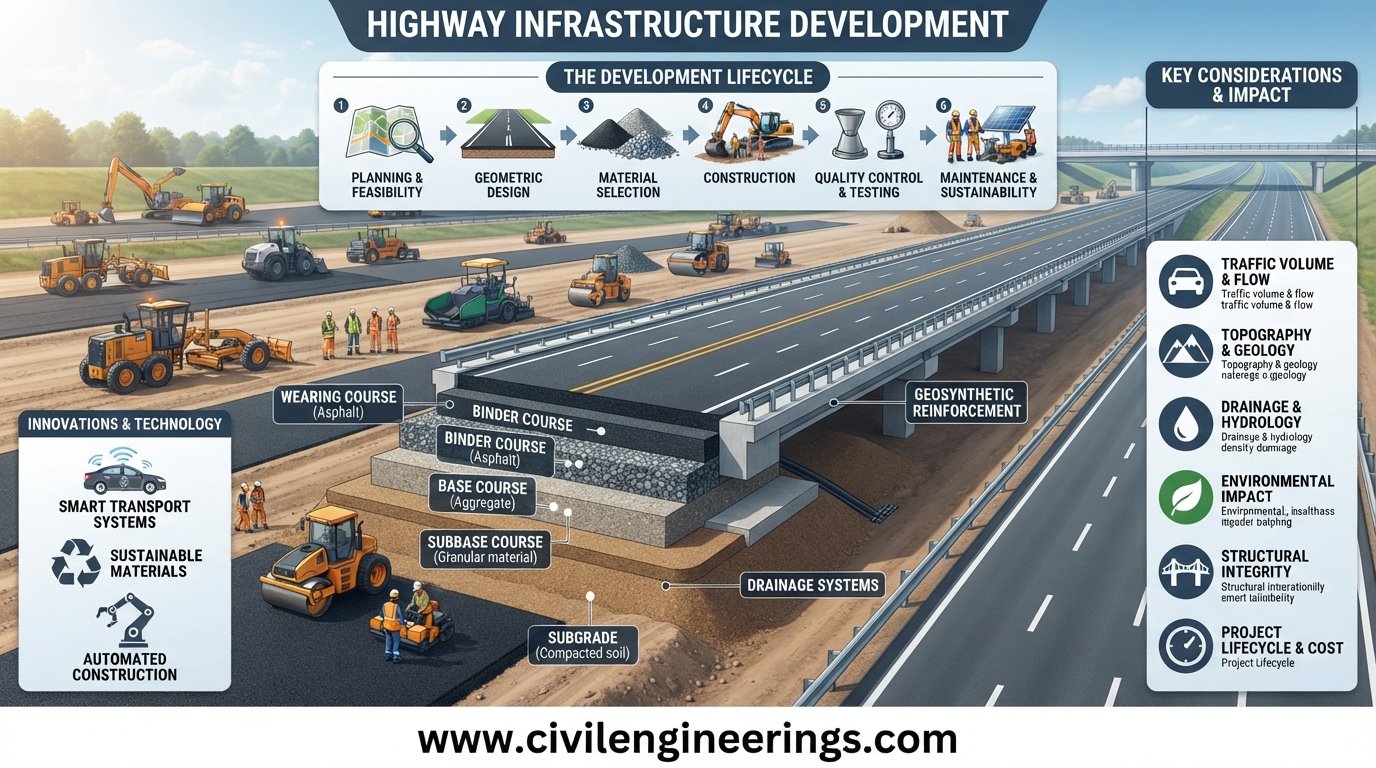
Highways are more than paved corridors connecting one city to another. They form the backbone of modern transportation systems, support trade and logistics, improve access to education and healthcare, and influence the economic growth of entire regions. A well-planned highway can reduce travel time, improve road safety, lower vehicle operating costs, and strengthen connections between urban and rural communities.
Highway Infrastructure Development is therefore a multidisciplinary process that begins long before construction equipment reaches the site. It involves transportation planning, corridor selection, feasibility studies, traffic analysis, land acquisition, geometric design, pavement engineering, drainage, structures, environmental assessment, construction management, and long-term maintenance.
For civil engineering students and practicing professionals, understanding this complete project lifecycle is essential. This guide explains how highway infrastructure develops from an initial transportation need into a functional and maintainable road facility. It also covers engineering principles, practical applications, standards, common challenges, and recommendations for students, engineers, contractors, consultants, and infrastructure organizations.
What Is Highway Infrastructure Development?
Highway infrastructure development refers to the systematic planning, design, construction, operation, maintenance, and improvement of highways and associated transportation facilities.
It includes much more than pavement construction. A highway project may involve:
- Road alignment and geometric design
- Traffic forecasting
- Right-of-way planning
- Earthwork and embankments
- Pavement structure
- Bridges and culverts
- Intersections and interchanges
- Drainage systems
- Roadside safety features
- Signs and pavement markings
- Lighting and intelligent transportation systems
- Environmental mitigation
- Maintenance and rehabilitation
The objective is to develop transportation infrastructure that is safe, efficient, economical, durable, accessible, and suitable for future traffic demand.
A highway must also work as part of a wider transportation network. Designing an isolated road without considering connecting roads, freight movement, public transport, land use, and future development can create operational problems later.
Why Highway Infrastructure Development Matters


Economic Development
Efficient highways reduce the time and cost required to move people and goods. Manufacturers depend on reliable transportation to receive raw materials and distribute finished products.
Improved highway connectivity can also encourage investment in industrial zones, commercial centers, logistics facilities, and residential development.
Regional Connectivity
Highways connect cities, towns, ports, airports, industrial areas, agricultural regions, and border crossings.
A properly developed road network can improve access to markets and public services while reducing isolation in remote communities.
Road Safety
Infrastructure quality has a direct relationship with road-user safety. Appropriate sight distance, lane width, intersection design, drainage, roadside protection, signs, markings, and pedestrian facilities all contribute to safer transportation.
Modern highway engineering increasingly follows a Safe System philosophy in which road design recognizes that human mistakes can occur and infrastructure should reduce the severity of resulting crashes.
Lower Transportation Costs
Good pavement condition reduces unnecessary vehicle fuel consumption, tire wear, suspension damage, and travel delays.
For freight operators, even modest reductions in travel time can have significant economic value when multiplied across thousands of trips.
Support for Urban and Rural Growth
A new highway can change development patterns. Rural communities may gain better market access, while growing cities may require bypasses, ring roads, expressways, and upgraded arterial corridors.
This is why highway development should be coordinated with land-use and regional development planning.
Major Stages of Highway Infrastructure Development
Highway infrastructure development follows a sequence of interconnected activities. The exact workflow varies by country, project type, funding arrangement, and contract strategy, but the following lifecycle provides a practical engineering framework.
1. Transportation Need Identification
Every highway project should begin with a clearly defined transportation problem.
Typical triggers include:
- Increasing traffic congestion
- Poor existing pavement condition
- High crash frequency
- Insufficient road capacity
- New industrial development
- Port or airport expansion
- Rural accessibility requirements
- Strategic national connectivity
- Flood or disaster resilience needs
The first question should not be, “Where should we build the road?”
It should be:
“What transportation problem are we trying to solve?”
This distinction prevents unnecessary infrastructure spending.
2. Feasibility Study
Once a transportation need is established, engineers and planners evaluate whether the proposed project is technically, economically, environmentally, and financially feasible.
A feasibility study commonly examines:
- Existing road network
- Traffic conditions
- Forecast traffic demand
- Alternative corridors
- Construction costs
- Land requirements
- Environmental constraints
- Social impacts
- Geological conditions
- Hydrology
- Economic benefits
- Project risks
Several alternatives may be compared before selecting the preferred option.
3. Traffic Data Collection and Forecasting
Traffic demand is one of the most important inputs in highway planning.
Engineers may collect:
- Average daily traffic
- Classified traffic counts
- Turning movements
- Axle-load information
- Origin-destination data
- Speed data
- Peak-hour traffic
- Pedestrian and bicycle movements
For a basic traffic-growth estimate, future traffic can be approximated using:
Where:
- = future traffic
- = current traffic
- = annual growth rate
- = number of years
For example, if current traffic is 20,000 vehicles/day and the assumed annual growth rate is 5% for 10 years:
The resulting demand helps engineers evaluate whether a two-lane highway, multilane highway, divided carriageway, or controlled-access facility is appropriate.
Actual design should use the traffic methodology and design-period requirements specified by the applicable authority.
Highway Corridor Selection and Route Planning


Route Selection
Selecting a highway corridor requires balancing engineering, economic, environmental, and social considerations.
Important factors include:
- Terrain
- Existing settlements
- Rivers and drainage channels
- Geological conditions
- Agricultural land
- Protected areas
- Existing utilities
- Property boundaries
- Future development
- Construction access
- Earthwork requirements
A route that appears short on a map may become expensive if it crosses unstable slopes, wetlands, major utilities, or heavily developed areas.
Preliminary and Detailed Surveys
Highway surveys progressively improve the accuracy of project information.
Typical activities include:
- Reconnaissance survey
- Preliminary survey
- Topographic survey
- Geotechnical investigation
- Hydrological investigation
- Detailed engineering survey
Modern projects may use GNSS, total stations, drones, LiDAR, digital terrain models, GIS, and remote sensing to improve data collection.
However, technology does not eliminate the need for engineering judgment. Survey data must be checked, coordinated, and interpreted correctly.
Highway Geometric Design
Geometric design determines the physical shape of the highway.
It covers:
- Horizontal alignment
- Vertical alignment
- Cross-section
- Sight distance
- Superelevation
- Lane widths
- Shoulder widths
- Medians
- Intersections
- Interchanges
- Access control
Design Speed
Design speed influences many geometric elements.
Higher design speeds generally require greater attention to:
- Curve radius
- Stopping sight distance
- Superelevation
- Vertical curves
- Clear zones
- Intersection spacing
The selected speed should reflect road function, terrain, expected traffic, land use, and applicable design standards.
Horizontal Curves
A horizontal curve connects two roadway tangents.
A simplified relationship between radius, speed, and superelevation can be expressed as:
Where:
- = curve radius in metres
- = speed in km/h
- = superelevation rate
- = side-friction factor
The actual equation, limiting values, and design procedure should follow the governing highway design standard.
Vertical Alignment
Vertical alignment controls changes in roadway elevation.
It includes:
- Grades
- Crest vertical curves
- Sag vertical curves
- Drainage considerations
- Heavy-vehicle performance
- Sight distance
Steep grades can reduce heavy-vehicle speeds and increase operating costs, while poorly designed vertical curves can restrict visibility.
Pavement Engineering in Highway Development
Pavement is one of the most important components of highway infrastructure.
Common pavement categories include:
Flexible Pavement
Flexible pavement commonly uses bituminous or asphalt layers over granular or stabilized layers.
A typical structure may contain:
- Wearing/surface course
- Binder course
- Base course
- Subbase
- Compacted subgrade
Performance depends on material quality, drainage, traffic loading, climate, construction quality, and maintenance.
Rigid Pavement
Rigid pavement generally uses concrete slabs to distribute traffic loads.
Its performance depends on factors such as:
- Concrete strength
- Slab thickness
- Joint design
- Load transfer
- Subbase support
- Drainage
- Temperature effects
Pavement Design Inputs
Pavement engineers normally consider:
- Design traffic
- Axle loads
- Subgrade strength
- Climate
- Material properties
- Reliability
- Drainage
- Design life
- Maintenance strategy
Subgrade investigation is particularly important because a strong pavement structure cannot fully compensate for poor construction practices or inadequate foundation preparation.
Earthwork, Subgrade and Embankment Construction
Before pavement layers are placed, contractors must establish a stable and properly compacted foundation.
Earthwork operations may include:
- Clearing and grubbing
- Excavation
- Borrow material selection
- Embankment construction
- Soil replacement
- Moisture conditioning
- Compaction
- Slope protection
Compaction Control
Field density testing verifies whether the constructed soil achieves the specified compaction.
A commonly used relationship is:
The required percentage depends on the material, layer, specification, and project standard.
Contractors should control moisture as well as compactive effort. Simply increasing roller passes does not always solve a poorly conditioned soil.
Drainage and Hydraulic Infrastructure
Water is one of the major causes of highway deterioration.
A highway drainage system may include:
- Side drains
- Cross-drainage structures
- Culverts
- Catch basins
- Median drainage
- Kerb and channel systems
- Subsurface drainage
- Bridge drainage
- Outfalls
Why Drainage Matters
Water can weaken pavement layers, erode embankments, destabilize slopes, and accelerate pavement failures.
Drainage design therefore needs to consider rainfall intensity, catchment characteristics, hydraulic capacity, flood levels, soil conditions, and downstream effects.
For small drainage structures, the rational method is commonly expressed as:
Where:
- = peak runoff
- = runoff coefficient
- = rainfall intensity
- = drainage area
Units must be kept consistent with the selected form of the equation and local design practice.
Bridges, Culverts and Other Highway Structures
A highway corridor frequently crosses rivers, railway lines, drainage channels, roads, and other obstacles.
Structural infrastructure may include:
- Bridges
- Box culverts
- Pipe culverts
- Underpasses
- Overpasses
- Retaining walls
- Viaducts
- Slope stabilization structures
Structural design requires coordination between highway geometry, geotechnical conditions, hydrology, structural engineering, construction staging, and long-term maintenance.
A bridge should never be treated as an isolated structure. Its approach roads, drainage, embankments, barriers, expansion arrangements, and pavement transitions all influence overall highway performance.
Road Safety Infrastructure
Highway safety extends beyond pavement and alignment.
Important safety elements include:
- Guardrails
- Crash barriers
- Median protection
- Delineators
- Warning signs
- Regulatory signs
- Guide signs
- Pavement markings
- Rumble strips
- Lighting
- Pedestrian crossings
- Safe bus stops
- Clear roadside zones
Road Safety Audit
A Road Safety Audit is a structured examination of a road project to identify potential safety problems.
Audits can be performed at different stages, including:
- Preliminary design
- Detailed design
- Pre-opening
- Existing-road stage
The purpose is not simply to identify crashes that have already occurred. It is to identify foreseeable safety risks before they become recurring problems.
Environmental and Social Considerations
Modern highway projects must account for environmental and community impacts.
Potential issues include:
- Vegetation removal
- Noise
- Dust
- Water pollution
- Wildlife movement
- Land acquisition
- Community severance
- Relocation
- Construction waste
- Carbon emissions
Environmental management should begin during corridor planning rather than after the alignment has already been fixed.
Possible mitigation measures include wildlife crossings, noise barriers, erosion control, sediment management, replanting, controlled construction access, and appropriate stormwater treatment.
Highway Construction Management
Once design and approvals are complete, construction converts engineering drawings into physical infrastructure.
Typical construction activities include:
- Site establishment
- Setting out
- Clearing and grubbing
- Earthwork
- Subgrade preparation
- Drainage construction
- Subbase placement
- Base-course construction
- Asphalt or concrete pavement
- Structures
- Road furniture
- Signs and markings
- Testing and commissioning
Quality Control
Quality control should operate throughout construction rather than only at project completion.
Common tests include:
- Soil compaction
- Aggregate gradation
- Aggregate crushing value
- Aggregate impact value
- Los Angeles abrasion
- Bitumen properties
- Asphalt density
- Concrete slump
- Concrete compressive strength
- Cement quality
- Field layer thickness
Inspection records, laboratory results, survey checks, material approvals, and nonconformance reports provide valuable evidence of construction quality.
Construction Safety
Contractors should establish a site-specific safety management system covering:
- Traffic management
- Worker protection
- Excavation safety
- Plant movement
- Lifting operations
- Night work
- Personal protective equipment
- Emergency response
Work-zone traffic control deserves special attention because construction activities introduce temporary hazards to both workers and road users.
Highway Maintenance and Asset Management
A highway is not finished when the contractor leaves the site.
Infrastructure requires continuous monitoring and maintenance.
Routine Maintenance
Routine work can include:
- Shoulder maintenance
- Drain cleaning
- Vegetation control
- Sign replacement
- Pavement marking renewal
- Minor pothole repair
- Guardrail maintenance
Periodic Maintenance
Periodic interventions may include:
- Asphalt overlays
- Surface treatments
- Crack sealing
- Milling and resurfacing
- Concrete joint rehabilitation
- Drainage rehabilitation
Pavement Management Systems
A pavement management system helps road agencies decide:
- Which roads require treatment
- What treatment is appropriate
- When intervention should occur
- How limited budgets should be allocated
Preventive maintenance is often more cost-effective than waiting until structural failure occurs.
Highway Standards and Engineering References
Highway projects should follow the standards and specifications adopted by the responsible road authority.
Internationally recognized references may include:
IRC
The Indian Roads Congress (IRC) publishes guidance covering highway geometric design, pavement design, traffic engineering, bridges, road safety, materials, and construction practices.
AASHTO
The American Association of State Highway and Transportation Officials (AASHTO) provides widely used transportation engineering guidance, including references for geometric design, pavement engineering, materials, and structural applications.
ICE
The Institution of Civil Engineers (ICE) provides professional knowledge, technical guidance, and engineering resources relevant to infrastructure development and project delivery.
These references should be treated as engineering guidance rather than universal substitutes for local requirements. The governing contract documents, national standards, road authority specifications, environmental regulations, and project-specific criteria always need to be checked.
Modern Trends in Highway Infrastructure Development
Technology is changing how highways are planned, designed, constructed, and managed.
Building Information Modeling
BIM can integrate geometric, structural, utility, quantity, and asset information into coordinated digital models.
GIS and Remote Sensing
GIS supports corridor analysis by combining terrain, land use, utilities, environmental constraints, and demographic information.
Drone-Based Surveying
Unmanned aerial systems can rapidly capture site imagery and terrain information, particularly on large corridors and difficult terrain.
Intelligent Transportation Systems
ITS technologies can improve:
- Traffic monitoring
- Incident detection
- Variable message signs
- Electronic tolling
- Travel-time information
- Traffic management
- Emergency response
Smart and Connected Highways
Future highway infrastructure may increasingly integrate connected vehicles, roadside sensors, automated traffic management, digital twins, renewable-energy systems, and predictive maintenance.
The objective should not be to adopt technology simply because it is new. Each technology should solve a measurable engineering or operational problem.
Sustainable Highway Infrastructure Development
Sustainability has become an important component of highway planning.
Engineers can improve sustainability through:
- Recycled pavement materials
- Optimized earthwork
- Longer pavement life
- Energy-efficient lighting
- Low-carbon materials
- Better drainage
- Vegetation management
- Construction waste reduction
- Reduced transportation distances for materials
- Climate-resilient infrastructure
A sustainable highway is not necessarily the project with the lowest initial construction cost. Life-cycle performance, environmental impact, maintenance requirements, resilience, and social benefits should also influence decision-making.
Common Challenges in Highway Projects
Highway projects frequently experience difficulties because they involve large areas, multiple stakeholders, complex construction activities, and long project durations.
Common challenges include:
- Land acquisition delays
- Utility conflicts
- Inaccurate surveys
- Unforeseen ground conditions
- Poor material quality
- Weak subgrade
- Drainage problems
- Design changes
- Contractor performance issues
- Traffic management difficulties
- Cost escalation
- Environmental constraints
- Extreme weather
The best defense is early investigation and disciplined project management.
A detailed geotechnical investigation, coordinated utility survey, realistic construction schedule, clear specifications, effective quality control, and strong communication can prevent many expensive problems.
Practical Recommendations for Civil Engineering Students
Students should avoid learning highway engineering only as a collection of formulas.
Focus on understanding why each design decision is made.
Useful activities include:
- Study highway geometric design principles.
- Practice traffic calculations.
- Learn pavement layer functions.
- Understand soil and aggregate testing.
- Read construction drawings.
- Visit highway construction sites.
- Learn surveying equipment.
- Practice AutoCAD and Civil 3D.
- Explore GIS applications.
- Study pavement failures and their causes.
- Read relevant IRC, AASHTO, and local specifications.
Site exposure is particularly valuable. Observing how drawings translate into setting out, earthwork, drainage, compaction, and pavement construction can significantly strengthen theoretical knowledge.
Practical Recommendations for Highway Engineers and Consultants
Engineers should maintain a systems-level view of the project.
Before approving a design, check:
- Is the traffic forecast defensible?
- Does the alignment provide adequate sight distance?
- Is drainage sufficient?
- Has the subgrade been properly investigated?
- Are utilities coordinated?
- Are road safety risks addressed?
- Can the contractor construct the proposed details?
- Are maintenance requirements understood?
- Does the design accommodate future demand?
Design optimization should consider construction and maintenance, not just theoretical compliance.
Practical Recommendations for Contractors
Contractors should establish quality from the beginning of construction.
Key practices include:
- Verify survey control before earthwork.
- Approve material sources early.
- Control moisture during compaction.
- Maintain layer thickness.
- Calibrate equipment.
- Perform field testing consistently.
- Protect completed work.
- Keep accurate records.
- Coordinate drainage with pavement construction.
- Follow approved traffic-management plans.
Good documentation is not merely administrative work. It provides evidence that construction complied with approved requirements and helps resolve technical disputes.
Frequently Asked Questions About Highway Infrastructure Development
What is highway infrastructure development?
Highway infrastructure development is the complete process of planning, investigating, designing, constructing, operating, maintaining, and upgrading highway facilities and associated infrastructure.
What are the main stages of highway development?
The major stages typically include need identification, feasibility study, traffic analysis, corridor selection, surveys, detailed design, approvals, procurement, construction, commissioning, operation, and maintenance.
Why is traffic forecasting important in highway projects?
Traffic forecasting helps engineers estimate future demand and select appropriate road capacity, pavement design, intersection arrangements, and investment levels.
What is the role of pavement engineering?
Pavement engineering determines suitable pavement materials, layer configurations, thicknesses, construction requirements, and maintenance strategies based on traffic, climate, subgrade, and design-life requirements.
Why is drainage important in highway infrastructure?
Poor drainage allows water to enter pavement and earthwork layers, which can weaken the subgrade, accelerate pavement deterioration, cause erosion, and reduce infrastructure life.
Which standards are used for highway design?
Standards depend on the project location and responsible authority. IRC and AASHTO references are widely used in different regions, while national road authorities and project specifications establish the governing requirements.
How does GIS help highway development?
GIS can combine terrain, land use, environmental constraints, settlements, utilities, existing roads, and other spatial information to support corridor selection and infrastructure planning.
What is the difference between highway construction and highway infrastructure development?
Highway construction mainly refers to physical implementation. Highway infrastructure development is broader and includes planning, feasibility, design, construction, operation, maintenance, rehabilitation, and long-term asset management.
How can highway projects become more sustainable?
Projects can improve sustainability through durable designs, recycled materials, optimized earthwork, lower-carbon construction, efficient drainage, reduced waste, renewable-energy applications, and life-cycle cost analysis.
Why should highway maintenance begin immediately after construction?
Because small defects can become major failures when ignored. Routine inspections and preventive maintenance help preserve pavement condition and extend the useful life of infrastructure.
Conclusion
Highway Infrastructure Development is a long-term engineering process that combines transportation planning, surveying, geotechnical engineering, geometric design, pavement engineering, drainage, structures, construction management, road safety, environmental protection, and asset management.
A successful highway is not simply a smooth strip of asphalt or concrete. It is an integrated transportation facility designed around actual travel demand, local conditions, safety requirements, economic objectives, environmental responsibilities, and future maintenance needs.
For students, understanding the complete project lifecycle provides a strong foundation for a career in civil and highway engineering. For practicing engineers and consultants, careful investigation, sound design judgment, quality control, and safety-focused decision-making remain essential. Contractors contribute through disciplined construction, testing, documentation, and site management.
The strongest highway projects are those that perform well not only on the opening day but throughout their intended service life. When planning, design, construction, and maintenance work together, highway infrastructure becomes a durable investment that supports mobility, commerce, regional development, and public safety for decades.

Kamran Malik is a passionate civil engineering writer and researcher who specializes in construction, transportation, structural engineering, and infrastructure topics. Through his articles on CivilEngineerings.com, he simplifies complex engineering concepts and shares practical insights, industry trends, and educational resources for students, professionals, and engineering enthusiasts.