
Introduction
Every successful road or highway project begins with accurate survey data. Before engineers design pavement layers, calculate earthwork quantities, or select the best highway alignment, they must understand the physical characteristics of the project site. This understanding comes from a well-planned Survey Workflow.
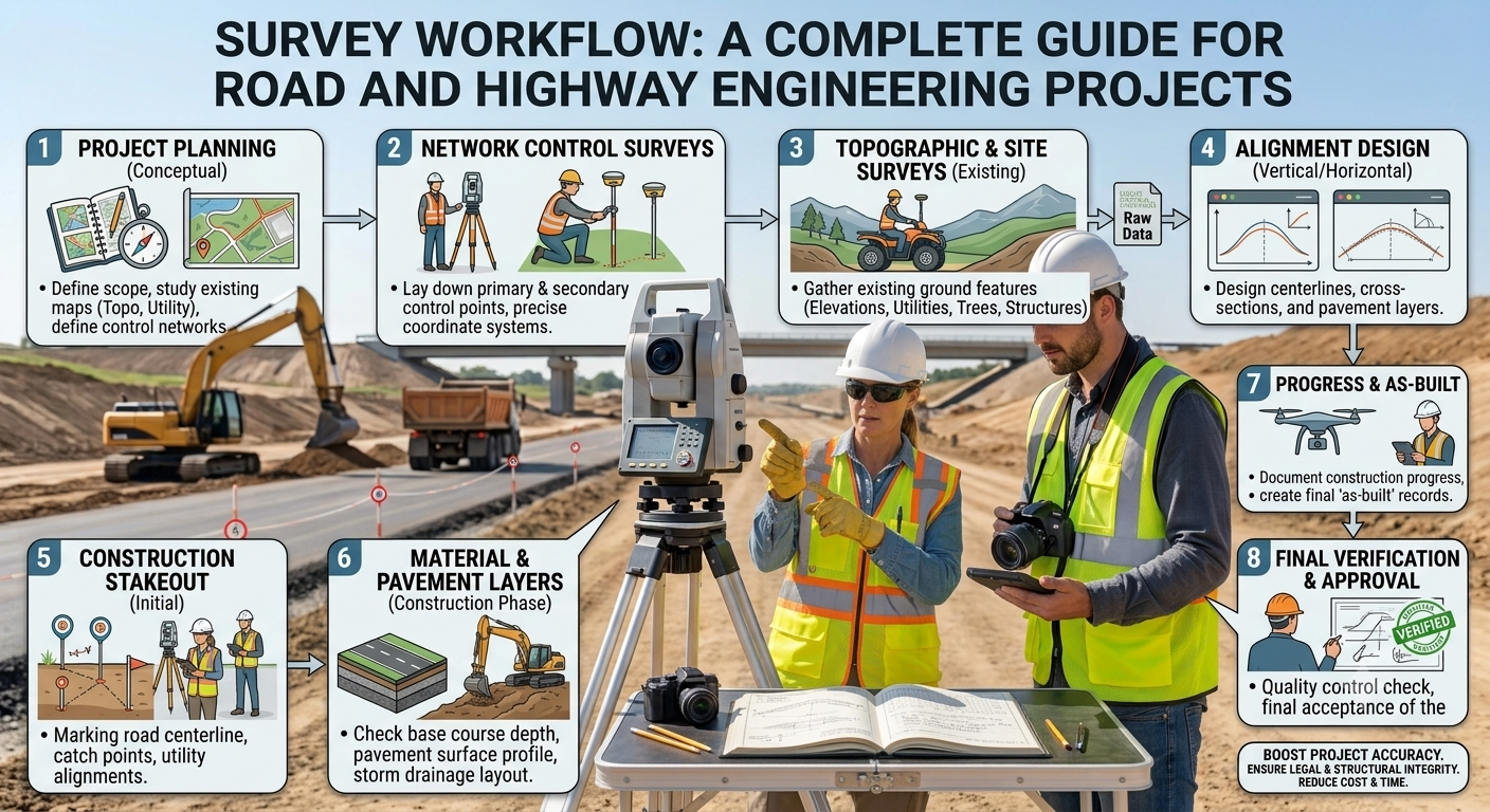
A survey workflow is a structured process that guides engineers and surveyors from the initial project briefing to the delivery of accurate field data. Each step ensures that measurements remain reliable, consistent, and suitable for engineering design. Poor survey planning often leads to incorrect designs, construction delays, additional costs, and safety issues. In contrast, an efficient survey workflow improves project quality, reduces errors, and supports better decision-making throughout the highway project lifecycle.
Modern road engineering combines traditional surveying techniques with advanced technologies such as GNSS, Total Stations, drones, LiDAR, and Geographic Information Systems (GIS). These tools enable engineers to collect highly accurate data while reducing field time and improving productivity.
Whether you are a civil engineer, highway designer, contractor, or engineering student, understanding the Survey Workflow helps you appreciate how reliable survey information forms the foundation of every successful transportation project.
What is Survey Workflow?
A Survey Workflow is the organized sequence of activities used to collect, process, verify, and deliver accurate spatial information for engineering projects. It establishes a clear path from planning field operations to producing survey drawings, digital terrain models, and engineering reports.
In highway engineering, survey workflow supports nearly every stage of project development. Engineers depend on survey data to determine road alignments, calculate earthwork volumes, design drainage systems, locate structures, and prepare construction drawings.
Unlike random field measurements, a structured workflow follows approved procedures, quality standards, and documentation practices. Each task builds on the previous one, creating a reliable chain of information that designers and contractors can trust.
Key Components of a Survey Workflow
A complete survey workflow generally includes:
- Project planning
- Site reconnaissance
- Establishment of survey control
- Field data collection
- Data processing
- Quality verification
- Preparation of survey deliverables
Each component contributes to the accuracy and efficiency of the overall project.
Why Survey Workflow Matters in Road Engineering
Surveying serves as the starting point of every road construction project. Even the most advanced engineering design cannot compensate for inaccurate field measurements.
A structured survey workflow delivers several important benefits:
Improves Design Accuracy
Accurate elevation data and coordinates enable engineers to design safe horizontal and vertical alignments while minimizing unnecessary earthwork.
Reduces Construction Errors
Reliable survey information prevents incorrect excavation depths, misplaced structures, and alignment deviations during construction.
Saves Time and Cost
Well-planned surveys reduce repeat field visits, minimize redesign efforts, and improve coordination among project teams.
Supports Better Decision-Making
Survey results provide engineers with essential information about terrain, existing utilities, drainage patterns, and natural obstacles.
Enhances Project Safety
Accurate location data helps avoid conflicts with underground utilities, existing infrastructure, and environmentally sensitive areas.
Objectives of Survey Workflow
The primary purpose of a survey workflow is to collect dependable information that supports planning, design, construction, and maintenance.
Major Objectives
1. Establish Accurate Ground Control
Survey control points provide fixed reference positions for every measurement taken during the project.
2. Collect Reliable Topographic Information
Engineers require detailed information about ground elevations, slopes, rivers, buildings, vegetation, and existing roads before preparing designs.
3. Support Highway Alignment Selection
Survey data allows engineers to compare different route alternatives and choose the safest and most economical alignment.
4. Estimate Earthwork Quantities
Accurate ground models help calculate cut-and-fill volumes, reducing material waste and improving construction planning.
5. Assist Drainage Design
Survey information identifies natural water flow patterns, enabling engineers to design effective culverts, side drains, and stormwater systems.
6. Improve Construction Accuracy
Construction survey teams use established control points to position roads, bridges, culverts, retaining walls, and other structures correctly.
7. Create Permanent Project Records
Survey reports, coordinate files, maps, and digital terrain models become valuable references for future maintenance, upgrades, and expansions.
Engineering Principles Behind Survey Workflow
Several engineering principles guide every successful survey operation.
Accuracy
Measurements must satisfy project tolerances and design requirements.
Precision
Repeated observations should produce consistent results.
Reliability
Survey data should remain dependable throughout the project lifecycle.
Traceability
Every measurement must relate to established control points and documented procedures.
Quality Assurance
Survey teams should verify field observations before using them in engineering design.
These principles ensure that survey information supports safe and economical highway construction.
Practical Applications of Survey Workflow
Survey workflow plays an essential role in many transportation engineering activities.
Common applications include:
- Highway route selection
- Expressway planning
- Rural road development
- Bridge location surveys
- Tunnel alignment
- Railway corridor surveys
- Airport runway design
- Urban road improvement projects
- Pavement rehabilitation
- Utility corridor mapping
Each application requires a systematic workflow to maintain accuracy and consistency.
Diagram 1: Basic Survey Workflow
          PROJECT REQUIREMENT
                  │
                  ▼
        PROJECT PLANNING
                  │
                  ▼
      RECONNAISSANCE SURVEY
                  │
                  ▼
      SURVEY CONTROL SETUP
                  │
                  ▼
      FIELD DATA COLLECTION
                  │
                  ▼
       DATA VERIFICATION
                  │
                  ▼
      SURVEY DRAWINGS &
       ENGINEERING DESIGN
Diagram Explanation
This workflow illustrates how survey activities progress from project planning to the delivery of engineering-ready information. Each stage depends on the successful completion of the previous one, ensuring accurate and reliable results for highway design and construction.
Key Takeaways
A structured Survey Workflow forms the backbone of every successful road and highway engineering project. It provides the accurate spatial data required for alignment design, earthwork estimation, drainage planning, and construction layout. By following established surveying principles and quality procedures, engineers reduce project risks, improve efficiency, and ensure that design decisions rely on dependable field information. As surveying technology continues to evolve, mastering the survey workflow remains an essential skill for engineers, contractors, and students alike.
Types of Surveys Used in Road Engineering
Different stages of a highway project require different types of surveys. Each survey provides unique information that supports planning, design, construction, and maintenance.
1. Reconnaissance Survey
A reconnaissance survey is the first field visit conducted to understand the project area. Surveyors inspect the terrain, identify obstacles, locate existing roads, and assess site accessibility.
Purpose:
- Evaluate terrain conditions
- Identify possible highway routes
- Locate natural and man made features
- Plan detailed survey activities
2. Control Survey
Control surveys establish permanent reference points with precise horizontal and vertical coordinates. These control points ensure that all subsequent measurements remain accurate and consistent.
Applications:
- Highway alignment
- Bridge construction
- Tunnel projects
- Earthwork layout
3. Topographic Survey
A topographic survey records the shape and elevation of the land, including hills, valleys, rivers, buildings, utilities, vegetation, and other surface features.
Importance:
- Supports road alignment design
- Assists drainage planning
- Provides data for earthwork calculations
4. Route Survey
A route survey focuses on the selected highway corridor. It gathers detailed information along the proposed alignment to support geometric design and construction planning.
5. Construction Survey
Construction surveys transfer the approved design from drawings to the field. Surveyors mark centerlines, boundaries, structure locations, and elevation references for contractors.
6. As-Built Survey
After construction, surveyors verify that the completed work matches the approved design. These surveys create permanent records for future maintenance and upgrades.
Survey Workflow Step by Step
Step 1: Project Planning
Every survey begins with careful planning. Engineers define project objectives, study available maps, review client requirements, and prepare a detailed survey plan.
Activities
- Review project scope
- Collect existing maps and records
- Select survey methods
- Prepare equipment lists
- Assign responsibilities
- Develop a field schedule
Good planning reduces delays and improves field efficiency.
Step 2: Reconnaissance Survey
The survey team visits the site to verify existing conditions before collecting detailed measurements.
Engineers Observe
- Terrain conditions
- Existing roads
- Buildings
- Rivers and streams
- Utility lines
- Access routes
- Vegetation
- Possible obstacles
This visit helps surveyors determine the most suitable survey methods and equipment.
Step 3: Establish Survey Control
Survey control provides fixed reference points that maintain measurement accuracy throughout the project.
Common Equipment
- GNSS receivers
- Total Stations
- Digital Levels
- Survey monuments
Survey control serves as the backbone of all subsequent field measurements.
Step 4: Field Data Collection
Once control points are established, surveyors begin collecting detailed site information.
Data Collected
- Ground elevations
- Coordinates
- Road centerlines
- Property boundaries
- Utilities
- Watercourses
- Existing structures
- Trees and vegetation
Modern equipment allows survey teams to collect thousands of accurate points within a single day.
Step 5: Data Verification
Before leaving the project site, surveyors verify all collected information.
Verification Includes
- Checking coordinate accuracy
- Confirming benchmark elevations
- Reviewing field notes
- Comparing redundant measurements
- Identifying missing observations
Early verification prevents costly repeat visits.
Step 6: Data Processing
Survey software converts raw field measurements into useful engineering information.
Typical Outputs
- Digital Terrain Models (DTM)
- Contour maps
- Cross sections
- Longitudinal profiles
- Coordinate files
- Survey drawings
Engineers use these outputs for highway design and quantity estimation.
Modern Survey Technologies
Technology has transformed road surveying by improving speed, safety, and accuracy.
Global Navigation Satellite System (GNSS)
GNSS provides highly accurate positioning over large project areas and reduces the need for extensive ground control.
Total Station
A Total Station combines electronic distance measurement with angle observation to produce precise coordinates.
LiDAR
LiDAR uses laser scanning to create detailed three-dimensional terrain models, especially in complex landscapes.
Unmanned Aerial Vehicles (Drones)
Drones quickly capture aerial imagery and generate orthophotos, digital elevation models, and surface maps.
Geographic Information System (GIS)
GIS organizes survey information, environmental data, utilities, and transportation networks into a single digital platform for planning and analysis.
Common Mistakes in Survey Workflow
Avoiding common mistakes improves survey quality and reduces project risks.
- Skipping reconnaissance surveys
- Using poorly calibrated equipment
- Failing to establish reliable control points
- Recording incomplete field notes
- Ignoring quality checks
- Using outdated coordinate systems
- Neglecting data backups
- Overlooking underground utilities
- Inadequate communication between survey and design teams
Best Practices
Following proven engineering practices ensures consistent survey results.
- Develop a detailed survey plan before fieldwork.
- Calibrate instruments regularly.
- Establish stable and well-documented control points.
- Verify measurements before leaving the site.
- Maintain organized digital records.
- Use appropriate surveying technology for project requirements.
- Follow recognized engineering standards and specifications.
- Conduct periodic quality assurance reviews.
- Protect survey monuments throughout construction.
- Coordinate closely with design and construction teams.
Practical Recommendations
Civil Engineers
- Review survey reports before starting geometric design.
- Validate terrain models against field conditions.
- Coordinate with geotechnical engineers during alignment selection.
- Maintain complete project documentation.
Contractors
- Confirm survey control before beginning construction.
- Protect benchmarks from damage.
- Verify layout points before excavation.
- Communicate immediately if discrepancies appear.
Engineering Students
- Learn both traditional and digital surveying methods.
- Practice using Total Stations and GNSS equipment.
- Understand coordinate systems and leveling principles.
- Visit active road construction sites to observe survey operations.
General Discussion on IRC, AASHTO, and ICE Practices
Leading highway organizations such as the Indian Roads Congress (IRC), the American Association of State Highway and Transportation Officials (AASHTO), and the Institution of Civil Engineers (ICE) emphasize the importance of accurate surveying throughout the project lifecycle.
Their general recommendations include:
- Establish reliable horizontal and vertical control.
- Complete detailed topographic and route surveys before design.
- Verify field measurements through quality control procedures.
- Maintain proper documentation and survey records.
- Use qualified personnel and calibrated equipment.
- Integrate survey data with design and construction management systems.
- Adopt modern technologies where appropriate while maintaining engineering accuracy.
Following these widely accepted principles improves project quality, reduces construction errors, and supports long-term infrastructure performance.
Frequently Asked Questions (FAQs)
1. What is a survey workflow in road engineering?
A survey workflow is the organized sequence of planning, field measurements, data processing, verification, and reporting used to support road and highway projects.
2. Why is survey workflow important?
It provides accurate spatial data for highway alignment, drainage design, earthwork calculations, construction layout, and quality control.
3. Which survey comes first in a highway project?
The reconnaissance survey usually comes first because it helps engineers understand site conditions and plan detailed fieldwork.
4. What equipment is commonly used during highway surveys?
Common equipment includes GNSS receivers, Total Stations, digital levels, drones, LiDAR systems, and GIS software.
5. What is the purpose of a control survey?
A control survey establishes accurate reference points that ensure consistency for all future measurements and construction activities.
6. How does survey workflow improve construction quality?
Accurate survey data reduces layout errors, prevents costly rework, improves alignment accuracy, and supports efficient project management.
7. What are the final deliverables of a survey workflow?
Typical deliverables include contour maps, digital terrain models, profiles, cross sections, coordinate files, survey drawings, and engineering reports.
8. Can drones replace traditional surveying methods?
Drones greatly improve efficiency and coverage, but engineers often combine them with GNSS and Total Stations to achieve the highest accuracy.
9. How often should survey equipment be calibrated?
Equipment should be calibrated according to manufacturer recommendations and project quality requirements to maintain measurement accuracy.
10. Who benefits from understanding survey workflow?
Civil engineers, transportation engineers, contractors, surveyors, project managers, and engineering students all benefit from understanding the complete survey workflow.
Conclusion
A well-structured Survey Workflow forms the foundation of every successful road and highway engineering project. From project planning and reconnaissance to control surveys, field data collection, verification, and digital processing, every stage contributes to accurate design and efficient construction. Reliable survey information enables engineers to select the best highway alignment, estimate earthwork quantities, design effective drainage systems, and avoid costly construction errors. Modern technologies such as GNSS, Total Stations, LiDAR, drones, and GIS have significantly improved survey accuracy and productivity, yet sound engineering judgment and quality control remain essential. By following recognized practices and maintaining accurate documentation throughout the project lifecycle, engineers and contractors can deliver safer, more durable, and cost-effective transportation infrastructure. Mastering the Survey Workflow equips students, professionals, and project teams with the knowledge required to plan, design, and construct highways with confidence and precision.

Kamran Malik is a passionate civil engineering writer and researcher who specializes in construction, transportation, structural engineering, and infrastructure topics. Through his articles on CivilEngineerings.com, he simplifies complex engineering concepts and shares practical insights, industry trends, and educational resources for students, professionals, and engineering enthusiasts.