
Introduction
Every successful road or highway project begins with reliable field data, but data alone cannot support engineering decisions. Engineers must organize, analyze, verify, and present that information in a professional document known as a survey report. A well-prepared survey report transforms raw measurements into meaningful engineering information that guides planning, design, budgeting, land acquisition, and construction.
Survey Report Preparation plays a critical role in civil engineering, transportation engineering, and infrastructure development. It provides project stakeholders with accurate details about existing site conditions, topography, utilities, property boundaries, drainage patterns, soil characteristics, and other essential information. Designers, contractors, consultants, and government agencies depend on these reports to make informed technical and financial decisions.
Whether you are preparing a report for a new highway, bridge, rural road, or urban street improvement project, following a systematic reporting process improves accuracy, reduces project risks, and minimizes costly design changes.
This guide explains the complete Survey Report Preparation process using engineering principles, practical examples, best practices, and professional reporting techniques suitable for engineers, contractors, and civil engineering students.
What is Survey Report Preparation?
Survey Report Preparation is the process of converting field survey observations, measurements, calculations, drawings, and technical analyses into a structured engineering document.
A survey report explains existing site conditions and provides accurate information for project planning and design. Instead of presenting only numerical data, the report interprets survey results and highlights their engineering significance.
A standard survey report may include:
- Project overview
- Survey objectives
- Site location
- Survey methodology
- Equipment used
- Field observations
- Topographic information
- Alignment details
- Utility mapping
- Photographs
- Drawings and plans
- Conclusions
- Engineering recommendations
A complete report allows every project stakeholder to understand site conditions without visiting the location.
Why Survey Report Preparation is Important
A professionally prepared survey report reduces uncertainty during project planning and construction. It provides a reliable technical foundation for engineering decisions and helps teams avoid costly errors.
Key Benefits
- Supports accurate highway design
- Improves project planning
- Reduces construction risks
- Simplifies land acquisition
- Helps estimate project costs
- Assists environmental assessments
- Improves communication among stakeholders
- Creates a permanent engineering record
Without a clear survey report, design engineers may rely on incomplete or inaccurate information, increasing the likelihood of redesign and construction delays.
Types of Survey Reports
Different engineering projects require different types of survey reports. The report format depends on the project scope and survey objectives.
Topographic Survey Report
This report describes:
- Existing ground levels
- Natural features
- Drainage patterns
- Buildings
- Roads
- Trees
- Utilities
It supports road alignment and grading design.
Route Survey Report
A route survey report focuses on linear infrastructure such as:
- Highways
- Railways
- Pipelines
- Canals
- Transmission lines
It includes alignment data, profiles, cross-sections, and route alternatives.
Boundary Survey Report
This report identifies legal property boundaries and land ownership information.
It supports:
- Land acquisition
- Property disputes
- Right-of-way planning
Construction Survey Report
Prepared during construction, this report verifies that completed work matches approved drawings and specifications.
As-Built Survey Report
An as-built report documents the final constructed position of roads, structures, drainage systems, and utilities after project completion.
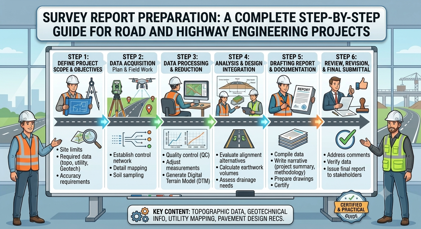
Survey Report Preparation Process
A professional survey report follows a logical sequence that ensures completeness, accuracy, and consistency.
Step 1: Define the Survey Objective
Every survey begins with a clearly defined objective.
Before entering the field, engineers determine what information the project requires and how the collected data will support design and construction.
Common Survey Objectives
- Highway route selection
- Road widening
- Bridge construction
- Land acquisition
- Drainage improvement
- Utility mapping
- Earthwork estimation
Questions Engineers Should Answer
- Why is the survey required?
- What information must be collected?
- Which standards apply?
- What level of accuracy is necessary?
- Who will use the report?
A well-defined objective prevents unnecessary fieldwork and improves reporting efficiency.
Step 2: Collect Field Data
Field data collection forms the backbone of every survey report.
Survey teams gather accurate measurements using modern surveying instruments and established field procedures.
Common Survey Equipment
- Total Station
- GNSS/GPS Receiver
- Digital Level
- Auto Level
- Drone (UAV)
- Measuring Wheel
- Laser Distance Meter
Information Commonly Collected
- Coordinates
- Elevations
- Benchmarks
- Existing roads
- Buildings
- Trees
- Utility poles
- Drainage channels
- Rivers
- Culverts
- Property boundaries
Best Practices During Fieldwork
- Calibrate equipment before use.
- Verify control points.
- Record weather conditions.
- Maintain detailed field notes.
- Check measurements regularly.
- Capture clear site photographs.
Accurate field observations reduce errors during report preparation.
Step 3: Verify and Validate Survey Data
Raw field measurements require verification before engineers use them for design.
Data validation confirms that measurements meet project accuracy requirements and contain no significant errors.
Verification Activities
- Compare field notes with digital data.
- Check coordinate consistency.
- Confirm benchmark elevations.
- Review missing observations.
- Validate instrument settings.
- Repeat doubtful measurements.
Engineering Importance
Early verification prevents:
- Incorrect alignment
- Earthwork calculation errors
- Design revisions
- Construction delays
- Cost overruns
Reliable data forms the basis of every successful engineering report.
Step 4: Organize and Process Survey Information
Once verification is complete, engineers organize the collected information into a structured format suitable for analysis and reporting.
Modern survey software processes field observations and converts them into engineering drawings and digital models.
Processing Activities
- Coordinate adjustment
- Data cleaning
- Point coding
- Surface modeling
- Contour generation
- Cross-section development
- Longitudinal profile creation
Software Commonly Used
- AutoCAD Civil 3D
- Bentley OpenRoads
- Trimble Business Center
- Leica Infinity
- GIS software
Organized data improves report readability and supports accurate engineering decisions.
Step 5: Prepare Survey Drawings and Maps
Engineering drawings communicate survey information more effectively than text alone.
Every professional survey report should include clear plans, profiles, and maps prepared according to project standards.
Typical Drawings
- Location map
- Site plan
- Topographic map
- Contour map
- Highway alignment plan
- Longitudinal profile
- Cross-sections
- Utility layout
- Drainage plan
Drawing Requirements
Each drawing should include:
- North arrow
- Scale
- Legend
- Coordinate system
- Benchmarks
- Title block
- Date
- Revision details
Well-prepared drawings reduce ambiguity and improve communication among project teams.
Survey Report Preparation Workflow Diagram
Project Requirement
        │
        ▼
Survey Planning
        │
        ▼
Field Data Collection
        │
        ▼
Data Verification
        │
        ▼
Data Processing
        │
        ▼
Drawings & Maps
        │
        ▼
Technical Report
Survey Report Structure Diagram
Survey Report
│
├── Project Information
├── Survey Objectives
├── Methodology
├── Equipment Used
├── Field Observations
├── Survey Drawings
├── Data Analysis
├── Technical Findings
├── Recommendations
└── Appendices
Engineering Best Practices
Professional engineers follow consistent practices to improve the quality of survey reports.
- Define survey objectives before fieldwork begins.
- Use calibrated and well-maintained surveying equipment.
- Establish reliable control points.
- Verify measurements before leaving the site.
- Organize digital files systematically.
- Prepare drawings using standard engineering conventions.
- Maintain complete field records and photographic documentation.
- Review calculations and maps before drafting the final report.
- Present findings in clear, concise, and logical sections.
- Ensure consistency between written observations and engineering drawings.
Key Takeaways
Survey Report Preparation transforms field observations into a structured engineering document that supports planning, design, and construction. The first five stages—defining objectives, collecting accurate field data, validating measurements, processing information, and preparing technical drawings—create the foundation of a reliable report. Careful execution of these steps improves design accuracy, reduces project risks, and strengthens communication among engineers, contractors, consultants, and project owners. A well-prepared survey report not only documents existing site conditions but also provides the confidence needed to move a road or highway project into the next stages of development.
Step 6: Write Technical Findings
After processing the survey data and preparing the drawings, engineers summarize the observations in a clear and logical manner. This section explains the actual site conditions instead of simply listing measurements.
A well-written findings section enables designers, consultants, contractors, and project owners to understand the engineering implications of the survey.
What Should Technical Findings Include?
- Existing ground conditions
- Terrain characteristics
- Road alignment observations
- Drainage conditions
- Existing utilities
- Structures and obstructions
- Property boundaries
- Access roads
- Environmental observations
- Potential construction challenges
Practical Example
Suppose a route survey identifies a low-lying area where water accumulates during heavy rainfall. Instead of only mentioning the elevation values, the report should explain that the area requires additional drainage structures or a raised embankment to prevent future flooding.
Tips for Writing Technical Findings
- Use simple engineering language.
- Present facts supported by survey data.
- Arrange observations in a logical sequence.
- Avoid unnecessary repetition.
- Include references to drawings and figures where applicable.
Step 7: Prepare Engineering Recommendations
A survey report should not end with observations alone. It should provide professional recommendations that help engineers make informed design and construction decisions.
Recommendations should be practical, technically sound, and based on verified survey results.
Common Engineering Recommendations
- Improve weak ground through soil stabilization.
- Modify the proposed alignment to reduce earthwork.
- Relocate utilities before construction.
- Install additional culverts in flood-prone areas.
- Protect existing trees where practical.
- Increase embankment height in low-lying sections.
- Carry out further geotechnical investigations if required.
- Establish permanent survey control points for construction.
Why Recommendations Matter
Good recommendations:
- Reduce project risks
- Improve safety
- Enhance constructability
- Lower maintenance costs
- Support sustainable development
Step 8: Review and Quality Check
Before submitting the report, engineers conduct a detailed quality review to verify accuracy, consistency, and completeness.
Quality control prevents technical errors that may affect project planning or construction.
Quality Review Checklist
- Verify all calculations.
- Confirm coordinate accuracy.
- Check benchmark elevations.
- Review contour intervals.
- Ensure drawing scales are correct.
- Confirm figure and table numbering.
- Check spelling and technical terminology.
- Match written observations with drawings.
- Verify photograph captions.
- Ensure all appendices are included.
Peer Review
Large infrastructure projects often require a second engineer or senior surveyor to review the report before approval. Independent review improves report quality and reduces the possibility of overlooked errors.
Step 9: Final Report Submission
Once the review process is complete, the survey report is finalized and submitted to the client, consultant, or project authority.
The report should follow a professional format and include all supporting documents.
Typical Survey Report Contents
- Cover page
- Project information
- Table of contents
- Executive summary
- Survey objectives
- Scope of work
- Survey methodology
- Equipment used
- Technical findings
- Survey drawings
- Photographs
- Engineering recommendations
- Appendices
- References
Submission Formats
Modern engineering firms commonly provide:
- Printed reports
- PDF documents
- CAD drawings
- GIS data
- Digital survey files
- Survey databases
A professionally formatted report improves communication and creates a permanent engineering record for future reference.
Common Mistakes in Survey Report Preparation
Even experienced professionals can make errors if proper procedures are not followed. Avoiding these common mistakes improves report quality and project reliability.
Frequent Mistakes
- Defining unclear survey objectives.
- Using uncalibrated survey equipment.
- Recording incomplete field notes.
- Ignoring data verification.
- Preparing drawings without checking coordinate systems.
- Omitting important site photographs.
- Writing vague technical observations.
- Providing recommendations without supporting evidence.
- Failing to review the report before submission.
- Using inconsistent units, symbols, or terminology.
Recognizing these issues early helps prevent design errors, construction delays, and unnecessary project costs.
Practical Recommendations
Civil Engineers
- Develop a standard survey report template for consistency.
- Review field data before leaving the project site.
- Coordinate closely with geotechnical, structural, and highway design teams.
- Keep digital and printed records organized for future reference.
Surveyors and Contractors
- Calibrate instruments regularly.
- Protect survey control points during construction.
- Record weather conditions and unusual site observations.
- Maintain clear communication with the design team.
Engineering Students
- Learn how field measurements translate into engineering drawings.
- Practice preparing reports using real or sample survey data.
- Understand the purpose of each survey type.
- Improve technical writing skills alongside surveying techniques.
- Familiarize yourself with modern surveying software and GIS applications.
General Discussion of IRC, AASHTO, and ICE Practices
Leading engineering organizations such as the Indian Roads Congress (IRC), the American Association of State Highway and Transportation Officials (AASHTO), and the Institution of Civil Engineers (ICE) emphasize the importance of accurate surveying and professional documentation throughout the project lifecycle.
Their guidance generally promotes the following principles:
- Collect reliable and verifiable field data.
- Establish permanent control points before design work begins.
- Follow recognized surveying methods and accepted accuracy standards.
- Document survey procedures and equipment used.
- Maintain consistency between survey data, engineering drawings, and technical reports.
- Conduct independent quality reviews before report approval.
- Preserve survey records for future maintenance and infrastructure upgrades.
- Integrate digital technologies such as GNSS, GIS, drones, and Building Information Modeling (BIM) where appropriate.
These principles improve project quality, reduce engineering risks, and support better decision-making during road and highway development.
Frequently Asked Questions (FAQs)
1. What is Survey Report Preparation?
Survey Report Preparation is the process of converting field survey observations, measurements, calculations, drawings, and analyses into a structured engineering document that supports planning, design, and construction.
2. Why is a survey report important in road engineering?
A survey report provides accurate information about existing site conditions, enabling engineers to design safe, economical, and technically sound road infrastructure.
3. What should a professional survey report include?
A complete report typically includes project details, survey objectives, methodology, equipment, field observations, technical findings, drawings, photographs, recommendations, and appendices.
4. Which software is commonly used for survey report preparation?
Common software includes AutoCAD Civil 3D, Bentley OpenRoads, Trimble Business Center, Leica Infinity, GIS platforms, and other specialized surveying applications.
5. How do engineers verify survey accuracy?
Engineers verify accuracy by checking control points, reviewing field notes, repeating doubtful measurements, validating coordinates, and conducting quality assurance reviews.
6. What are the benefits of using digital surveying technologies?
Digital tools improve accuracy, reduce field time, simplify data processing, enhance visualization, and streamline report preparation.
7. Who uses survey reports?
Survey reports are used by civil engineers, transportation engineers, consultants, contractors, architects, government agencies, utility companies, and project owners.
8. What is the difference between a topographic survey report and a route survey report?
A topographic survey report focuses on natural and man made site features, while a route survey report concentrates on the alignment and characteristics of linear infrastructure such as highways and railways.
9. What is the role of quality control in survey reporting?
Quality control ensures that all measurements, calculations, drawings, and written observations are accurate, complete, and consistent before the report is submitted.
10. How often should survey reports be updated?
Survey reports should be updated whenever significant site changes occur, design revisions are introduced, or additional field investigations become necessary.
Conclusion
Survey Report Preparation is one of the most important stages in the planning and design of road and highway projects. A professionally prepared report transforms raw survey data into valuable engineering information that supports safe design, efficient construction, and informed decision-making. From defining clear objectives and collecting accurate field measurements to preparing detailed drawings, writing technical findings, and conducting thorough quality reviews, every step contributes to the overall success of an infrastructure project. Well-organized survey reports reduce engineering risks, improve communication among project stakeholders, and minimize costly design changes during construction. Engineers, surveyors, contractors, and students who master Survey Report Preparation develop stronger technical documentation skills and contribute to higher-quality infrastructure projects. By following established engineering practices, maintaining data accuracy, and presenting information in a clear, structured format, professionals can produce survey reports that remain reliable references throughout the entire lifecycle of a road or highway project.
