
Introduction
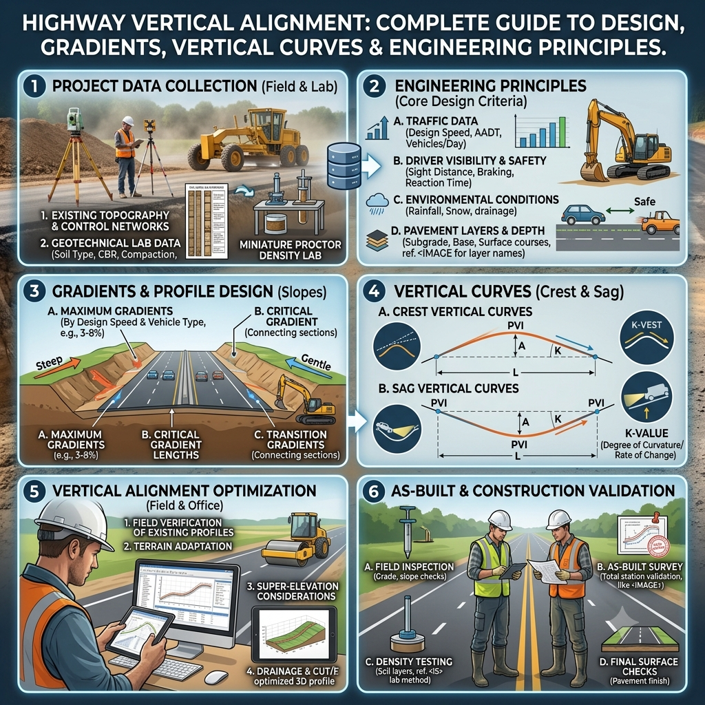
A highway performs efficiently only when its horizontal and vertical geometry work together. While horizontal alignment controls the roadway’s direction, Highway Vertical Alignment defines the elevation profile along the road’s centerline. Engineers design this profile to provide smooth vehicle movement, adequate sight distance, efficient drainage, and driver comfort.
Every highway project relies on proper vertical alignment to ensure safety and long-term pavement performance. Poor elevation design increases fuel consumption, reduces visibility, creates drainage problems, and accelerates pavement deterioration. Engineers carefully evaluate terrain, traffic characteristics, design speed, and construction costs before finalizing the vertical profile.
Understanding Highway Vertical Alignment helps civil engineers, highway designers, contractors, and students develop safer and more economical transportation infrastructure. This guide explains the fundamental concepts, design principles, gradients, vertical curves, and practical engineering applications based on widely accepted highway engineering practices.
What is Highway Vertical Alignment?
Highway Vertical Alignment refers to the design of the roadway’s elevation along its centerline. It defines how the road rises, falls, and transitions between different elevations over its length.
Unlike horizontal alignment, which controls the direction of travel, vertical alignment controls the roadway’s profile. Engineers design it to ensure smooth vehicle movement, adequate stopping sight distance, efficient drainage, and comfortable driving conditions.
The vertical profile consists of straight gradient sections connected by carefully designed vertical curves. These curves eliminate abrupt changes in slope and improve driver safety.
A well-designed vertical alignment balances engineering performance, construction cost, environmental conditions, and user comfort.
Importance of Highway Vertical Alignment
Vertical alignment influences nearly every aspect of highway performance. Proper elevation design improves operational efficiency and reduces long-term maintenance requirements.
Major Benefits
- Improves road safety.
- Provides sufficient stopping sight distance.
- Enhances driver comfort.
- Promotes efficient surface drainage.
- Reduces fuel consumption.
- Minimizes earthwork costs.
- Improves pavement durability.
- Supports higher travel speeds.
- Reduces vehicle wear and tear.
Poor vertical alignment often results in:
- Limited visibility.
- Water accumulation.
- Increased accident risk.
- Driver discomfort.
- Higher construction costs.
- Premature pavement damage.
Objectives of Highway Vertical Alignment
The primary objective is to develop a roadway profile that satisfies engineering, economic, environmental, and operational requirements.
Key objectives include:
- Ensure safe vehicle operation.
- Maintain adequate sight distance.
- Provide smooth transitions between gradients.
- Minimize excavation and embankment work.
- Improve riding quality.
- Facilitate efficient drainage.
- Reduce construction and maintenance costs.
- Enhance overall highway performance.
Components of Highway Vertical Alignment
Several elements combine to form the complete vertical profile of a highway.
1. Formation Level
The formation level represents the finished elevation of the prepared roadbed before pavement construction begins.
It determines:
- Embankment height
- Excavation depth
- Drainage arrangements
- Pavement thickness requirements
2. Natural Ground Level (NGL)
Natural Ground Level is the original ground elevation before any earthwork takes place.
Engineers compare the formation level with the natural ground to calculate:
- Cutting quantities
- Filling quantities
- Earthwork balance
- Project cost
3. Gradients
A gradient is the rate at which the road rises or falls over a specified horizontal distance.
Gradient is commonly expressed as:
- Percentage (%)
- Ratio (1 in 50)
- Decimal value
Formula
Gradient (%) = (Vertical Rise ÷ Horizontal Distance) × 100
Example
A road rises 4 meters over a horizontal distance of 200 meters.
Gradient = (4 ÷ 200) × 100 = 2%
This means the road climbs 2 meters for every 100 meters of horizontal distance.
4. Vertical Curves
Vertical curves connect two different gradients smoothly.
Without these curves, sudden changes in slope would create unsafe driving conditions and uncomfortable vehicle movement.
Vertical curves improve:
- Sight distance
- Driver comfort
- Vehicle stability
- Pavement performance
- Drainage efficiency
Engineering Principles of Highway Vertical Alignment
Engineers follow several key principles while designing highway vertical profiles.
Maintain Safe Sight Distance
Drivers must clearly see obstacles ahead and have enough distance to stop safely.
Balance Earthwork
The alignment should minimize excessive cutting and filling to reduce project costs.
Coordinate Horizontal and Vertical Alignment
Sharp horizontal curves combined with steep vertical grades can reduce visibility and compromise safety.
Ensure Proper Drainage
The roadway should allow rainwater to flow quickly toward side drains without ponding on the pavement surface.
Improve Driving Comfort
Smooth changes in slope reduce vehicle bouncing and improve ride quality.
Types of Highway Gradients
Gradient selection depends on terrain, traffic volume, design speed, and vehicle performance.
1. Ruling Gradient
The ruling gradient is the desirable maximum gradient used under normal conditions.
Engineers adopt this gradient wherever practical because it provides efficient vehicle operation and economical construction.
Characteristics
- Best operating condition.
- Suitable for long highway sections.
- Improves fuel efficiency.
- Reduces vehicle strain.
2. Limiting Gradient
When site constraints prevent the use of the ruling gradient, engineers may adopt a limiting gradient for short distances.
Common Situations
- Mountainous terrain
- Urban development
- River crossings
- Existing structures
Although acceptable, limiting gradients should remain as short as possible.
3. Exceptional Gradient
An exceptional gradient exceeds the limiting gradient and is used only under unavoidable conditions.
Examples include:
- Bridge approaches
- Tunnel portals
- Restricted mountainous locations
Engineers use these gradients sparingly because they reduce vehicle performance and increase operating costs.
4. Minimum Gradient
Even on apparently level roads, engineers provide a small minimum gradient to facilitate drainage.
Without sufficient slope, rainwater accumulates on the pavement, increasing hydroplaning risk and accelerating pavement deterioration.
Types of Vertical Curves
Vertical curves connect different grades while maintaining safety and driving comfort.
Two major categories exist.
Summit Curve (Crest Curve)
A summit curve connects an ascending gradient with a descending gradient.
Purpose
- Improve sight distance.
- Provide smooth transitions.
- Increase driving comfort.
- Reduce accident risk.
Common Applications
- Hilltops
- Overpasses
- Highway crests
Valley Curve (Sag Curve)
A valley curve connects a descending gradient with an ascending gradient.
Purpose
- Improve riding comfort.
- Reduce vehicle impact.
- Provide smooth drainage.
- Enhance nighttime visibility.
Common Applications
- Depressions
- River crossings
- Underpasses
- Highway valleys
Practical Engineering Example
Suppose engineers are designing a four-lane divided highway across rolling terrain.
The existing ground rises steeply before descending toward a river crossing. Instead of creating abrupt elevation changes, the design team introduces a ruling gradient followed by a crest curve to improve sight distance. After the river crossing, they use a sag curve to provide a smooth transition into the next ascending section.
This approach enhances driver comfort, reduces fuel consumption, improves drainage, and minimizes earthwork by balancing excavation and embankment quantities.
Highway Vertical Alignment Diagram
Basic Vertical Alignment Profile
                 Summit Curve
                     /\
                    /  \
                   /    \
------------------/      \------------------
      Upgrade                  Downgrade
Valley Curve
-----------------\      /-------------------
                  \    /
                   \  /
                    \/
                 Valley Curve
Relationship Between Ground and Road Profile
Road Profile
────────────────────────────────────

        Fill
       ███████
------█████████----------------------

Natural Ground
~~~~~~~~~~~~~~~^^^^^^^^~~~~~~~~~~~~~~
      Cut Area
Key Takeaways
Highway Vertical Alignment forms the backbone of a safe and efficient roadway profile. By combining properly selected gradients with well-designed summit and valley curves, engineers create highways that deliver smooth traffic flow, adequate sight distance, reliable drainage, and long-term pavement performance. Successful vertical alignment also balances construction costs by optimizing earthwork while improving driving comfort and operational safety. Understanding these core principles provides a strong foundation for advanced highway design and prepares engineers, contractors, and students.
Design Criteria for Highway Vertical Alignment
Designing an effective Highway Vertical Alignment requires balancing safety, comfort, economy, drainage, and environmental considerations. Highway engineers evaluate several factors before finalizing the vertical profile.
1. Design Speed
Design speed directly influences the length and shape of vertical curves. Higher speeds require longer crest and sag curves to provide sufficient stopping sight distance and smooth vehicle operation.
Example:
An expressway designed for 120 km/h requires longer vertical curves than a rural road designed for 60 km/h.
2. Sight Distance
Adequate sight distance allows drivers to identify hazards and stop safely. Engineers design crest curves to provide:
- Stopping Sight Distance (SSD)
- Overtaking Sight Distance (OSD), where applicable
- Decision Sight Distance (DSD) on complex facilities
Restricted visibility on hilltops increases accident risk, making proper vertical alignment essential.
3. Terrain Conditions
The surrounding landscape significantly affects vertical alignment.
Flat Terrain
- Gentle gradients
- Minimal earthwork
- Lower construction costs
- Better driver comfort
Rolling Terrain
- Moderate cuts and fills
- Combination of crest and sag curves
- Balanced earthwork design
Mountainous Terrain
- Steeper gradients
- Extensive retaining structures
- Tunnel and bridge considerations
- Higher construction costs
4. Drainage Requirements
Water is one of the biggest threats to pavement performance. Engineers design vertical alignment to ensure rainwater flows quickly toward side drains and culverts.
Proper drainage helps:
- Prevent water ponding
- Reduce pavement deterioration
- Protect embankments
- Improve driving safety during rainfall
5. Earthwork Optimization
Highway projects often involve significant excavation and embankment work. Designers aim to balance cut and fill quantities to reduce material transportation and construction costs.
A balanced earthwork plan:
- Saves construction time
- Reduces fuel consumption
- Lowers project costs
- Minimizes environmental disturbance
Factors Affecting Highway Vertical Alignment
Several engineering, environmental, and economic factors influence the final roadway profile.
Traffic Characteristics
- Traffic volume
- Heavy vehicle percentage
- Future traffic growth
- Operating speed
Heavy truck traffic generally requires flatter gradients to maintain vehicle performance and safety.
Soil and Geology
Weak soils, expansive clays, and unstable rock formations often require modifications to the proposed alignment.
Engineers may recommend:
- Soil stabilization
- Geosynthetics
- Ground improvement
- Alternative alignments
Climate and Weather
Environmental conditions influence pavement durability and roadway safety.
Design considerations include:
- Heavy rainfall
- Snowfall
- Flooding
- Frost action
- Extreme temperatures
Environmental Constraints
Engineers strive to minimize impacts on:
- Forests
- Wetlands
- Wildlife habitats
- Rivers
- Protected areas
Environmentally responsible alignments support sustainable infrastructure development.
Existing Infrastructure
Highway alignment should integrate efficiently with:
- Existing roads
- Railways
- Utility corridors
- Bridges
- Airports
- Urban developments
Construction Best Practices
Proper construction practices ensure that the designed vertical alignment is accurately transferred to the field.
Accurate Surveying
Survey teams should verify:
- Centerline coordinates
- Elevation benchmarks
- Cross sections
- Grade stakes
Modern technologies such as GNSS, total stations, drones, and digital levels improve construction accuracy.
Quality Earthwork
Earthwork operations should include:
- Controlled excavation
- Layer-by-layer filling
- Moisture conditioning
- Proper compaction
- Continuous inspection
Each embankment layer should meet specified density requirements before placing the next layer.
Continuous Grade Verification
Construction engineers should frequently check roadway elevations to ensure compliance with design drawings.
Routine checks help prevent:
- Uneven profiles
- Incorrect slopes
- Drainage problems
- Costly rework
Drainage Installation
Drainage facilities should be installed concurrently with earthworks.
Properly constructed drainage systems protect:
- Pavement layers
- Embankments
- Slopes
- Adjacent properties
Field Recommendations
Civil Engineers
- Review survey data before approving alignment.
- Coordinate horizontal and vertical alignment during design.
- Verify earthwork calculations regularly.
- Monitor compaction and grading operations throughout construction.
Contractors
- Use calibrated surveying equipment.
- Follow approved grade stakes.
- Protect completed embankments from erosion.
- Correct drainage issues immediately.
- Avoid shortcuts during compaction.
Engineering Students
- Study roadway profile drawings carefully.
- Practice calculating gradients and elevations.
- Understand the purpose of crest and sag curves.
- Visit active highway construction sites to observe grading operations.
Common Mistakes to Avoid
Many highway problems result from poor vertical alignment decisions or construction errors.
Common mistakes include:
- Providing insufficient sight distance.
- Using excessively steep gradients.
- Ignoring drainage requirements.
- Combining sharp horizontal curves with crest curves.
- Poor embankment compaction.
- Inaccurate surveying.
- Unbalanced cut-and-fill design.
- Neglecting future traffic growth.
- Ignoring maintenance considerations.
Avoiding these mistakes improves highway safety, durability, and long-term performance.
General Discussion of IRC, AASHTO, and ICE Practices
Leading highway engineering organizations promote similar principles for designing safe and efficient vertical alignments.
Generally accepted recommendations include:
- Select gradients appropriate for terrain and design speed.
- Provide adequate stopping sight distance on crest curves.
- Design smooth sag curves to improve ride quality and nighttime visibility.
- Coordinate horizontal and vertical alignments for consistent driver perception.
- Balance earthwork quantities wherever practical.
- Ensure efficient surface and subsurface drainage.
- Conduct accurate topographic and geotechnical investigations before finalizing the profile.
- Follow rigorous quality control during construction.
Applying these principles contributes to safer, more economical, and longer-lasting highways.
Best Practices for Highway Vertical Alignment
- Complete detailed topographic surveys before design.
- Select gradients that suit expected traffic conditions.
- Minimize abrupt elevation changes.
- Design vertical curves that provide smooth transitions.
- Integrate drainage into the alignment from the beginning.
- Balance excavation and embankment quantities.
- Verify grades continuously during construction.
- Use quality-controlled materials and compaction techniques.
- Coordinate geometric design with environmental considerations.
- Plan for future traffic expansion whenever possible.
Frequently Asked Questions (FAQs)
1. What is Highway Vertical Alignment?
Highway Vertical Alignment is the design of the roadway’s elevation profile along its centerline, including gradients and vertical curves that ensure safe, comfortable, and efficient vehicle movement.
2. Why is vertical alignment important in highway engineering?
It improves road safety, provides adequate sight distance, enhances drainage, reduces vehicle operating costs, and extends pavement life.
3. What are the main components of Highway Vertical Alignment?
The primary components include formation level, natural ground level, gradients, and vertical curves.
4. What is the difference between a summit curve and a valley curve?
A summit (crest) curve connects an uphill grade to a downhill grade, while a valley (sag) curve connects a downhill grade to an uphill grade, creating smooth transitions between slopes.
5. What factors influence Highway Vertical Alignment?
Terrain, design speed, traffic volume, soil conditions, drainage, environmental constraints, construction costs, and existing infrastructure all influence the final alignment.
6. Why are gradients limited on highways?
Steep gradients reduce vehicle performance, increase fuel consumption, create safety concerns, and make heavy vehicles more difficult to operate.
7. How does vertical alignment affect drainage?
Proper gradients direct surface water toward drainage systems, preventing water accumulation and protecting pavement layers from moisture damage.
8. Which technologies improve vertical alignment construction?
GNSS receivers, total stations, drones, digital levels, Building Information Modeling (BIM), and machine-controlled grading systems improve construction accuracy.
9. How does vertical alignment influence construction costs?
Optimized alignments reduce excavation, embankment quantities, retaining structures, and material transportation, leading to lower overall project costs.
10. Which standards guide Highway Vertical Alignment design?
Highway engineers generally follow the principles outlined in recognized publications such as IRC, AASHTO, and ICE guidance, while complying with applicable national standards and project specifications.
Conclusion
Highway Vertical Alignment plays a fundamental role in the success of every highway project. A well-designed vertical profile improves driver safety, provides adequate sight distance, enhances drainage, reduces earthwork costs, and increases pavement durability. Engineers achieve these objectives by carefully selecting gradients, designing smooth summit and valley curves, and coordinating the vertical profile with horizontal alignment and site conditions. Accurate surveying, proper construction practices, and continuous quality control further ensure that the finished roadway performs as intended throughout its design life. By applying proven engineering principles and following recognized guidance from organizations such as IRC, AASHTO, and ICE, engineers, contractors, and students can design and construct highways that deliver safe, efficient, and sustainable transportation. Mastering Highway Vertical Alignment is therefore essential for every civil engineering professional involved in road infrastructure development.

Kamran Malik is a passionate civil engineering writer and researcher who specializes in construction, transportation, structural engineering, and infrastructure topics. Through his articles on CivilEngineerings.com, he simplifies complex engineering concepts and shares practical insights, industry trends, and educational resources for students, professionals, and engineering enthusiasts.