
Introduction
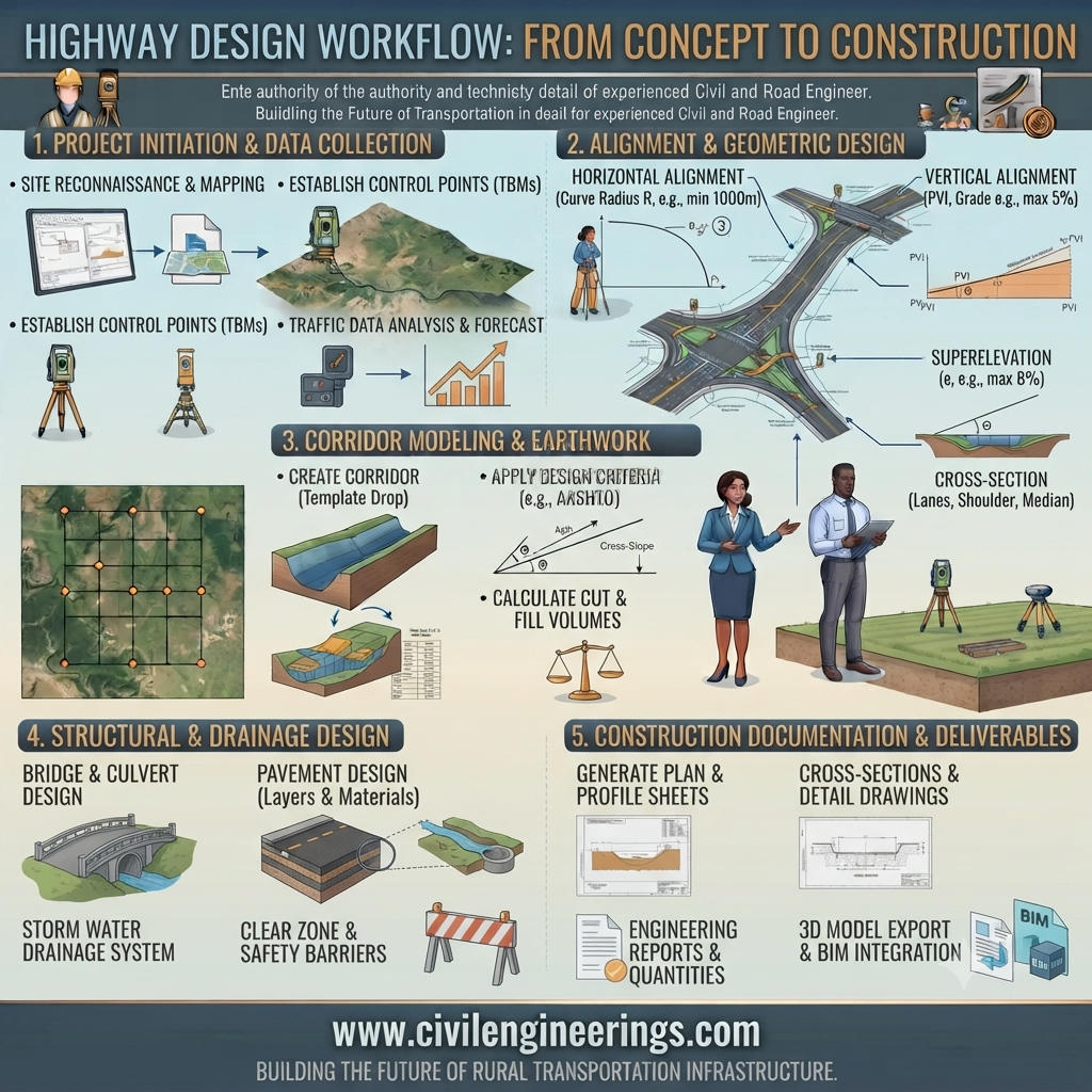
Every successful highway begins long before construction equipment arrives on site. Behind every safe, durable, and efficient roadway lies a carefully planned Highway Design Workflow that transforms transportation needs into a fully engineered infrastructure project. From identifying traffic demand and selecting the most suitable route to designing pavement structures and drainage systems, each stage plays a critical role in ensuring long-term performance and public safety.
Whether you are a civil engineering student, highway engineer, contractor, consultant, or researcher, understanding the complete highway design process is essential for making informed engineering decisions. This guide explains each stage of the Highway Design Workflow using practical engineering concepts, real-world applications, design principles, and industry best practices. By the end of this article, you will understand how modern highways are planned, analyzed, designed, and prepared for construction.
Understanding Highway Design Workflow
The Highway Design Workflow is a systematic engineering process used to convert transportation requirements into detailed construction-ready designs. Rather than focusing solely on road geometry, the workflow integrates traffic engineering, geotechnical engineering, hydrology, environmental planning, pavement engineering, structural engineering, economics, and safety analysis.
Each stage builds upon the previous one, reducing uncertainties before construction begins. A structured workflow minimizes design errors, controls project costs, improves safety, and enhances the overall service life of the highway.
The workflow generally consists of:
- Planning
- Site Investigation
- Data Collection
- Preliminary Design
- Detailed Design
- Design Review
- Construction Documentation
- Quality Assurance
Why Highway Design Workflow Matters
An organized highway design process provides numerous engineering and economic benefits.
Improved Safety
Proper alignment, visibility, intersection design, and drainage significantly reduce accident risks while improving driving comfort.
Cost Optimization
Identifying engineering challenges early minimizes expensive redesigns and construction delays.
Environmental Protection
Early environmental assessments help reduce impacts on ecosystems, water bodies, wildlife habitats, and surrounding communities.
Better Pavement Performance
Accurate soil investigation and traffic forecasting ensure that pavement thickness is designed to withstand expected loads over its intended service life.
Regulatory Compliance
Following established engineering procedures simplifies approvals from highway authorities and funding agencies while ensuring compliance with national and international guidelines.
Major Phases of Highway Design Workflow
1. Project Identification
Every highway project begins by recognizing the need for new transportation infrastructure or improvements to an existing roadway.
Typical reasons include:
- Traffic congestion
- Economic development
- Population growth
- Industrial expansion
- Tourism development
- Safety improvements
- Regional connectivity
At this stage, planners evaluate transportation demand and define project objectives.
Typical deliverables include:
- Project scope
- Initial traffic demand
- Planning maps
- Preliminary budget estimate
- Stakeholder identification
2. Feasibility Study
The feasibility study determines whether the proposed highway project is technically, economically, environmentally, and socially viable.
Engineers evaluate:
- Multiple route alternatives
- Estimated construction costs
- Environmental impacts
- Social impacts
- Land acquisition requirements
- Economic benefits
- Traffic demand projections
Typical Feasibility Study Components
- Traffic forecasting
- Cost-benefit analysis
- Environmental screening
- Utility relocation assessment
- Risk identification
- Preliminary geometric design
Projects that demonstrate favorable technical and economic outcomes proceed to detailed investigations.
3. Traffic Investigation
Traffic engineering forms one of the most important components of the Highway Design Workflow.
Design decisions depend heavily on projected traffic volumes and vehicle composition.
Engineers typically collect:
- Average Daily Traffic (ADT)
- Annual Average Daily Traffic (AADT)
- Peak Hour Volume (PHV)
- Vehicle classification
- Axle load data
- Turning movement counts
- Speed studies
- Origin-destination surveys
Traffic Growth Forecast
Future traffic is commonly estimated using projected annual growth rates over the design life of the highway.
Basic Formula
Future Traffic = Present Traffic × (1 + r)^n
Where:
- r = annual growth rate
- n = design years
Example Calculation
Present AADT = 18,000 vehicles/day
Growth Rate = 4%
Design Period = 20 years
Future AADT
= 18,000 × (1.04)^20
≈ 39,438 vehicles/day
This forecast influences:
- Number of lanes
- Pavement design
- Intersection capacity
- Bridge widths
- Drainage sizing
4. Topographic Survey
Topographic surveys provide the physical characteristics of the proposed corridor.
Survey data includes:
- Ground elevations
- Existing roads
- Rivers
- Buildings
- Utilities
- Trees
- Property boundaries
- Contours
Modern surveys commonly use:
- Total Stations
- GPS/GNSS
- UAV (Drone) Mapping
- LiDAR
- Digital Terrain Models (DTM)
Importance
Accurate topographic information allows engineers to optimize horizontal and vertical alignments while reducing unnecessary earthwork.
5. Geotechnical Investigation
No highway can perform well without understanding the soil beneath it.
Geotechnical investigations determine the engineering properties of the subgrade and foundation materials.
Typical investigations include:
- Boreholes
- Trial pits
- Soil sampling
- Laboratory testing
- Groundwater assessment
Common Soil Tests
- California Bearing Ratio (CBR)
- Standard Proctor Test
- Modified Proctor Test
- Grain Size Analysis
- Atterberg Limits
- Moisture Content
- Specific Gravity
- Plate Load Test
The results influence:
- Pavement thickness
- Embankment design
- Slope stability
- Foundation selection
- Drainage design
Highway Design Workflow Diagram
Transportation Need
        │
        ▼
Project Identification
        │
        ▼
Feasibility Study
        │
        ▼
Traffic Investigation
        │
        ▼
Topographic Survey
        │
        ▼
Geotechnical Investigation
        │
        ▼
Preliminary Highway Design
        │
        ▼
Detailed Engineering Design
        │
        ▼
Construction Drawings
        │
        ▼
Tender Documents
        │
        ▼
Construction
Engineering Design Inputs
A successful Highway Design Workflow relies on accurate engineering inputs collected during planning and investigation stages.
Key inputs include:
- Design speed
- Traffic volume
- Vehicle classification
- Terrain type
- Soil properties
- Rainfall intensity
- Drainage characteristics
- Climate conditions
- Material availability
- Construction methods
- Utility locations
- Environmental constraints
- Right-of-way limits
- Future traffic projections
- Economic considerations
Each input directly affects design decisions related to roadway geometry, pavement thickness, drainage capacity, earthwork quantities, and construction costs.
Preliminary Engineering Considerations
Before detailed design begins, engineers establish several preliminary design parameters that influence the overall highway layout.
Design Speed
Design speed governs geometric features such as curve radius, stopping sight distance, and superelevation. Higher design speeds generally require flatter curves, longer sight distances, and wider clear zones.
Terrain Classification
The surrounding terrain—whether flat, rolling, mountainous, or urban—affects alignment selection, earthwork volumes, and construction complexity. Choosing an alignment that fits the natural landscape can significantly reduce excavation and embankment costs.
Right-of-Way Requirements
Adequate right-of-way must be reserved to accommodate the roadway, shoulders, drainage facilities, utilities, future widening, and maintenance access. Early planning helps minimize land acquisition issues and project delays.
Environmental Constraints
Sensitive ecosystems, watercourses, protected habitats, and nearby communities should be identified early so that the alignment can avoid or mitigate adverse impacts through appropriate engineering solutions.
Preliminary and Detailed Highway Design
Once field investigations are complete, engineers begin transforming collected data into an optimized highway layout. This stage balances safety, construction feasibility, environmental considerations, and long-term maintenance requirements.
Horizontal Alignment
Horizontal alignment determines the roadway’s path in plan view. A well-designed alignment improves driving comfort, minimizes accident risks, and reduces construction costs.
Key considerations include:
- Design speed
- Minimum curve radius
- Transition curves
- Super elevation
- Sight distance
- Terrain constraints
- Existing infrastructure
Vertical Alignment
Vertical alignment defines the roadway profile and elevation changes.
Engineers design:
- Gradients
- Crest curves
- Sag curves
- Drainage slopes
- Vertical clearances
The objective is to provide smooth vehicle movement while ensuring adequate visibility and effective stormwater drainage.
Typical Alignment Relationship
Plan View

--------\
         \
          ) Curve
         /
--------/

Profile View

______/''''''\______
     Crest Curve
Pavement Design Workflow
Pavement design converts traffic loading and subgrade strength into a durable pavement structure capable of serving the expected design life.
Typical pavement layers include:
- Surface Course
- Binder Course
- Base Course
- Sub base
- Compacted Subgrade
 Asphalt Surface
====================
 Binder Layer
--------------------
 Base Course
====================
 Sub base
--------------------
 Compacted Soil
====================
 Natural Ground
Key Inputs
- Design traffic (ESALs)
- CBR value
- Subgrade modulus
- Material properties
- Drainage conditions
- Climate
- Design life
Simplified Engineering Concept
Higher traffic loads or weaker soils generally require thicker pavement sections. Conversely, stronger subgrades and lower traffic volumes may permit thinner, more economical designs.
Basic Engineering Calculation Example
Although detailed pavement design uses specialized methods, traffic growth can be estimated using:
Future Traffic
[
F = P(1+r)^n
]
Where:
- F = Future traffic
- P = Present traffic
- r = Annual growth rate
- n = Design period (years)
Example
Present AADT = 25,000 vehicles/day
Growth = 5%
Design Life = 20 years
Future Traffic
= 25,000 × (1.05)^20
≈ 66,333 vehicles/day
This projected traffic volume influences:
- Lane requirements
- Pavement thickness
- Shoulder design
- Bridge loading
- Drainage capacity
Highway Drainage Design
Drainage is one of the most important components of a successful Highway Design Workflow. Even a well-designed pavement can fail prematurely if water is allowed to infiltrate the pavement layers or weaken the subgrade.
Engineers design drainage systems to:
- Remove surface runoff quickly
- Prevent water accumulation
- Protect embankments
- Reduce erosion
- Extend pavement life
Typical drainage elements include:
- Side drains
- Longitudinal drains
- Cross-drainage structures
- Culverts
- Stormwater channels
- Catch basins
Proper drainage planning significantly lowers maintenance costs over the highway’s service life.
Quality Control During Highway Construction
A sound design must be supported by rigorous quality control during construction. Testing verifies that materials and workmanship meet project specifications.
California Bearing Ratio (CBR) Test
Measures the strength of the subgrade soil and is commonly used for pavement design.
Proctor Test
Determines the optimum moisture content and maximum dry density for soil compaction.
Marshall Stability Test
Evaluates the stability and flow characteristics of asphalt mixtures.
Slump Test
Checks the workability and consistency of fresh concrete used in bridges, culverts, and retaining structures.
Core Test
Measures in-place asphalt thickness and density after pavement construction.
Field Density Test
Confirms that compacted soil, sub base, and base layers achieve the required density.
Plate Load Test
Assesses the bearing capacity and deformation characteristics of foundation soils where required.
Consistent testing throughout construction helps ensure durability, structural performance, and compliance with design expectations.
Best Practices
Highway Engineers
- Conduct comprehensive site investigations before finalizing designs.
- Integrate traffic, geotechnical, and drainage data into every design decision.
- Use modern surveying technologies such as GNSS, LiDAR, and UAV mapping where appropriate.
- Coordinate closely with environmental and utility specialists to avoid costly redesigns.
- Perform independent design reviews before issuing construction drawings.
Contractors
- Follow approved construction drawings and specifications.
- Maintain strict quality control for materials and workmanship.
- Ensure proper compaction at every pavement layer.
- Protect drainage systems during construction.
- Document inspections and testing results for future reference.
Civil Engineering Students
- Develop a strong understanding of geometric design principles.
- Learn how traffic studies influence highway planning.
- Practice interpreting survey data and geotechnical reports.
- Understand the relationship between pavement design and soil properties.
- Stay updated with current engineering practices and digital design tools.
Common Mistakes in Highway Design
Even experienced teams can encounter avoidable issues if the workflow is not followed carefully.
Common mistakes include:
- Inadequate traffic forecasting
- Insufficient geotechnical investigation
- Poor drainage planning
- Ignoring future roadway expansion
- Inaccurate topographic surveys
- Underestimating environmental impacts
- Improper pavement material selection
- Weak coordination among design disciplines
- Incomplete quality assurance documentation
Addressing these issues early reduces project risks and improves long-term highway performance.
General Overview of Engineering Standards
Professional highway projects are generally developed with reference to recognized engineering guidance issued by national and international organizations. While specific requirements vary by country and project type, these organizations provide widely accepted principles for design, testing, construction, and quality management.
- IRC (Indian Roads Congress): Publishes guidance for highway planning, geometric design, pavement engineering, traffic management, and bridge design used extensively in India.
- AASHTO (American Association of State Highway and Transportation Officials): Provides internationally respected recommendations for geometric design, pavement design, bridge engineering, and transportation planning.
- ASTM International: Develops standardized laboratory and field testing methods for soils, aggregates, asphalt, concrete, and construction materials.
- ICE (Institution of Civil Engineers): Promotes engineering best practices, professional development, and infrastructure excellence.
- ISO (International Organization for Standardization): Establishes quality management, environmental management, and process improvement standards applicable to infrastructure projects.
- FHWA (Federal Highway Administration): Offers technical guidance, research publications, and best practices covering roadway safety, asset management, pavement performance, and sustainable transportation.
Engineers should always consult the latest editions of applicable standards and comply with local regulatory requirements.
Frequently Asked Questions
1. What is the Highway Design Workflow?
The Highway Design Workflow is the structured sequence of planning, investigation, design, review, and documentation activities required to develop a safe, economical, and durable highway project. It begins with identifying transportation needs and progresses through feasibility studies, traffic analysis, site investigations, geometric design, pavement design, drainage planning, quality assurance, and construction documentation. Following a logical workflow reduces design errors, improves coordination among disciplines, and helps deliver projects that meet technical, environmental, and economic objectives.
2. Why is traffic forecasting important?
Traffic forecasting estimates future demand based on current traffic volumes and expected growth. These projections influence the number of lanes, pavement thickness, bridge capacity, intersection design, and overall roadway geometry. Accurate forecasts help prevent premature congestion or unnecessary oversizing, making the highway both efficient and cost-effective throughout its intended service life.
3. How does geotechnical investigation affect highway design?
Geotechnical investigations determine soil strength, compressibility, groundwater conditions, and other subsurface characteristics. These findings guide pavement thickness, embankment stability, foundation selection, and drainage strategies. Without reliable soil data, highways may experience settlement, cracking, or premature pavement failure, increasing maintenance costs and reducing service life.
4. Why is drainage considered a critical part of highway engineering?
Water is one of the leading causes of pavement deterioration. Effective drainage removes runoff, prevents water from infiltrating pavement layers, and protects embankments from erosion. Properly designed drainage systems improve pavement durability, reduce maintenance requirements, and enhance road safety by minimizing standing water and hydroplaning risks.
5. Which quality control tests are commonly performed during construction?
Quality control typically includes CBR tests for subgrade evaluation, Proctor tests for compaction characteristics, Marshall Stability tests for asphalt mixtures, Slump tests for concrete workability, Core tests for asphalt thickness and density, Field Density tests for compaction verification, and Plate Load tests where foundation performance must be assessed. These tests ensure that construction meets design requirements.
6. Which software is commonly used in highway design?
Modern highway projects often use software such as AutoCAD Civil 3D, Bentley OpenRoads, MX Road, InfraWorks, GIS platforms, pavement design applications, and traffic simulation tools. These programs improve design accuracy, facilitate collaboration, and help engineers visualize alignments, earthworks, drainage networks, and construction sequencing before work begins.
Conclusion
A successful Highway Design Workflow is far more than a sequence of engineering tasks—it is a coordinated process that integrates planning, traffic engineering, surveying, geotechnical investigations, geometric design, pavement engineering, drainage, quality control, and professional review into a single, reliable framework. Each stage builds on accurate data and sound engineering judgment, helping create highways that are safe, durable, economical, and capable of meeting future transportation demands. By understanding this workflow, engineers, contractors, students, and consultants can make informed decisions that improve project quality and reduce long-term maintenance costs. Apply these principles consistently, stay aligned with recognized engineering guidance, and continue developing your technical expertise to deliver infrastructure that serves communities for decades.

Kamran Malik is a passionate civil engineering writer and researcher who specializes in construction, transportation, structural engineering, and infrastructure topics. Through his articles on CivilEngineerings.com, he simplifies complex engineering concepts and shares practical insights, industry trends, and educational resources for students, professionals, and engineering enthusiasts.