
Introduction
Every successful infrastructure project begins with one essential requirement—understanding the land on which it will be built. Whether designing a highway through mountainous terrain, planning a railway corridor, constructing a dam, or developing an urban township, engineers must first analyze the Earth’s surface accurately. Even a small mistake in representing ground elevations can lead to costly design errors, drainage problems, excessive earthwork, or construction delays.
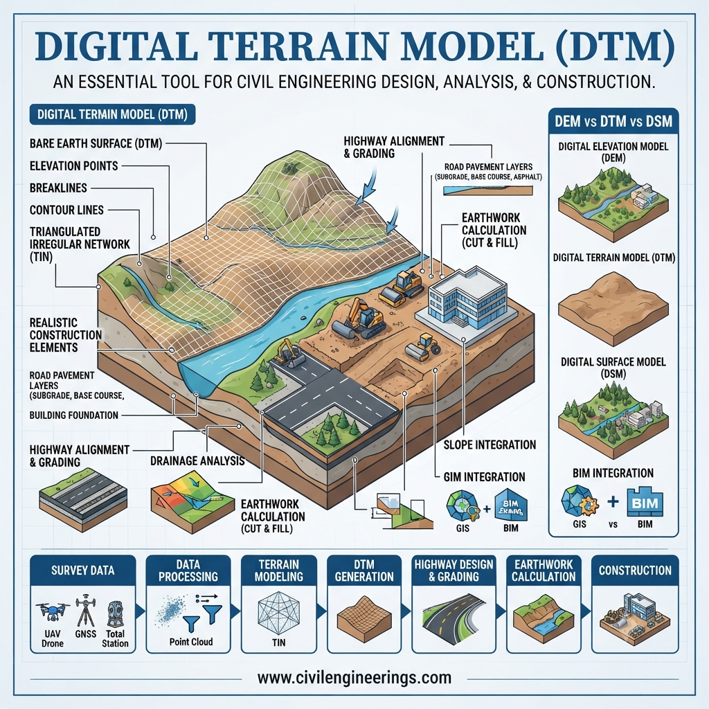
This is where the Digital Terrain Model (DTM) becomes an indispensable engineering tool. A Digital Terrain Model provides a highly accurate digital representation of the bare ground surface by removing objects such as buildings, trees, and vegetation. It allows engineers to study terrain characteristics, calculate earthwork volumes, optimize alignments, and improve decision-making throughout the project lifecycle.
In modern civil engineering, transportation engineering, and land surveying, DTMs have transformed traditional topographic analysis into a fast, precise, and data-driven process. Combined with technologies like GPS, drones, LiDAR, GIS, and BIM, they enable professionals to design safer, more economical, and environmentally sustainable infrastructure.
This comprehensive guide explains everything you need to know about the Digital Terrain Model, including its definition, components, creation methods, engineering applications, benefits, limitations, and industry best practices for real-world projects.
What is a Digital Terrain Model (DTM)?
A Digital Terrain Model (DTM) is a three-dimensional digital representation of the Earth’s bare surface that accurately depicts ground elevations after removing surface objects such as buildings, trees, bridges, vehicles, and vegetation.
Unlike ordinary elevation maps, a DTM contains not only elevation values but also additional terrain information such as:
- Breaklines
- Slope characteristics
- Ridge lines
- Valleys
- Drainage paths
- Surface continuity
This additional information allows engineers to understand how the terrain behaves under natural conditions.
A Digital Terrain Model serves as the foundation for many engineering analyses, including:
- Highway alignment design
- Railway route planning
- Drainage system design
- Earthwork estimation
- Flood modeling
- Watershed analysis
- Infrastructure planning
- Construction site grading
Simply put, the DTM represents the actual land surface that engineers use for design and analysis.
Difference Between Digital Terrain Model, DEM, and DSM
Many students confuse DTM, DEM, and DSM because all three represent elevation data. However, each serves a different purpose in engineering.
| Model | Represents | Includes Trees & Buildings | Engineering Use |
|---|---|---|---|
| Digital Elevation Model (DEM) | Ground elevation | Usually No | General terrain analysis |
| Digital Terrain Model (DTM) | Bare earth with terrain features | No | Engineering design and construction |
| Digital Surface Model (DSM) | Surface including objects | Yes | Urban planning, telecommunications, visibility studies |
Digital Elevation Model (DEM)
A DEM is a basic grid of elevation values representing terrain. It is suitable for general mapping and regional studies but lacks detailed terrain characteristics.
Digital Terrain Model (DTM)
A DTM improves upon a DEM by incorporating structural terrain information such as breaklines, ridges, drainage channels, and slope changes. This makes it ideal for engineering applications where precision is critical.
Digital Surface Model (DSM)
A DSM captures everything visible from above, including buildings, vegetation, power lines, and other structures. It is commonly used for city planning, telecommunications, and solar energy analysis.
Why Digital Terrain Models Are Important
Modern infrastructure projects depend heavily on accurate terrain information. Incorrect elevation data can affect every stage of planning and construction.
A well-developed Digital Terrain Model helps engineers:
- Understand existing site conditions
- Reduce design errors
- Improve road alignment selection
- Optimize cut-and-fill operations
- Design efficient drainage systems
- Estimate construction costs accurately
- Improve project safety
- Support environmental assessments
- Minimize unnecessary excavation
- Reduce project risks
Without an accurate DTM, engineering decisions often rely on incomplete or outdated topographic information.
Components of a Digital Terrain Model
A high-quality Digital Terrain Model contains much more than elevation points. Several interconnected components work together to represent the terrain accurately.
1. Elevation Points
These are the fundamental data points that define the height of the ground relative to a reference datum.
Each point contains:
- Easting
- Northing
- Elevation
Thousands—or even millions—of elevation points are collected during field surveys.
2. Breaklines
Breaklines define sudden changes in terrain where slopes change abruptly.
Examples include:
- Road edges
- Drainage channels
- River banks
- Retaining walls
- Ridge lines
- Embankments
- Cut slopes
Breaklines improve the accuracy of terrain interpolation between survey points.
3. Triangulated Irregular Network (TIN)
A TIN connects surveyed points using irregular triangles.
This structure:
- Represents complex terrain efficiently
- Preserves natural slope variations
- Accurately models uneven landscapes
- Supports detailed engineering analysis
TIN models are widely used in highway and infrastructure projects because they adapt well to irregular ground conditions.
4. Contours
Contour lines are generated automatically from the Digital Terrain Model.
They help engineers visualize:
- Terrain shape
- Ground elevations
- Steep slopes
- Valleys
- Hills
- Watersheds
Contour maps remain one of the most common outputs of DTM processing.
5. Surface Features
Important terrain characteristics incorporated into a DTM include:
- Peaks
- Saddles
- Depressions
- Drainage channels
- Watershed boundaries
- Natural slopes
These features assist engineers in selecting safe and economical project layouts.
How a Digital Terrain Model Is Created
Creating a reliable Digital Terrain Model involves several carefully planned stages, each contributing to the overall accuracy of the final surface model.
Step 1: Data Collection
The process begins with collecting accurate ground elevation data using modern surveying technologies.
Common methods include:
Total Station Survey
Surveyors measure individual ground points using total stations. This method provides high precision and is suitable for small to medium-sized projects.
GNSS/GPS Survey
Global Navigation Satellite System (GNSS) and GPS equipment enable rapid collection of georeferenced elevation points across large project areas.
Drone Survey (UAV Photogrammetry)
Unmanned Aerial Vehicles (UAVs) equipped with high-resolution cameras capture overlapping aerial images. Specialized photogrammetry software converts these images into dense point clouds and terrain models, making drone surveys ideal for highways, mining, and large construction sites.
LiDAR Survey
Light Detection and Ranging (LiDAR) uses laser pulses to measure distances between the sensor and the ground. Airborne LiDAR can penetrate vegetation to generate highly accurate bare-earth models, making it one of the most reliable methods for complex terrain.
Satellite Remote Sensing
Satellite imagery provides elevation data for regional and national-scale planning where ground surveys may not be practical. Although less detailed than LiDAR or drone surveys, it is valuable for preliminary studies.
Step 2: Data Processing
Raw survey data often contains errors, noise, and points representing vegetation, buildings, or temporary structures.
Engineers process the collected information by:
- Removing outliers
- Filtering non-ground objects
- Classifying terrain points
- Correcting elevation inconsistencies
- Aligning datasets to the required coordinate system
This cleaning process ensures the resulting terrain model accurately reflects the natural ground surface.
Step 3: Surface Modeling
Once the data has been processed, specialized software generates the Digital Terrain Model by interpolating between surveyed points.
Common interpolation techniques include:
- Triangulated Irregular Network (TIN)
- Grid-based interpolation
- Kriging
- Inverse Distance Weighting (IDW)
- Natural Neighbor interpolation
The choice of method depends on terrain complexity, data density, and project requirements.
Step 4: Quality Verification
Before a DTM is used for design, engineers perform quality checks to verify its reliability.
Typical verification activities include:
- Comparing DTM elevations with field survey checkpoints
- Reviewing contour consistency
- Checking breakline accuracy
- Identifying interpolation errors
- Validating slope and drainage patterns
A well-verified Digital Terrain Model forms a dependable foundation for highway design, site grading, drainage planning, and earthwork estimation.
Technologies Used to Create Digital Terrain Models
Advances in geospatial technology have significantly improved the speed and accuracy of DTM generation. Common tools and platforms include:
- GNSS/GPS Receivers for high-precision positioning
- Total Stations for detailed topographic surveys
- UAVs (Drones) for aerial photogrammetry
- LiDAR Systems for dense point-cloud acquisition
- GIS Software such as ArcGIS and QGIS for terrain analysis
- CAD and Civil Design Software like AutoCAD Civil 3D, Bentley OpenRoads, and Trimble Business Center for surface modeling
- BIM Platforms for integrating terrain data with infrastructure design
These technologies enable engineers to create accurate terrain models that support planning, design, construction, and asset management across a project’s lifecycle.
Engineering Principles Behind Digital Terrain Modeling
A Digital Terrain Model (DTM) is much more than a three-dimensional map of the ground. It is an engineering dataset that supports analysis, design, and decision-making throughout the lifecycle of an infrastructure project. Every terrain model should represent the existing ground as accurately as possible while maintaining the correct horizontal and vertical relationships between terrain features.
The following engineering principles form the foundation of a reliable DTM.
Accurate Elevation Representation
The quality of every engineering design depends on accurate elevation data. Ground levels determine roadway gradients, drainage flow, earthwork quantities, retaining wall heights, and structural foundations. Even minor elevation errors can lead to costly construction modifications.
Terrain Continuity
Natural landforms change gradually except at distinct features such as ridges, streams, embankments, and retaining walls. A DTM should preserve these changes without creating unrealistic peaks or depressions during interpolation.
Breakline Preservation
Breaklines define abrupt changes in slope. Incorporating breaklines into a DTM ensures that important terrain features such as road edges, riverbanks, and drainage channels remain accurately represented.
Appropriate Data Density
Flat terrain generally requires fewer survey points, while mountainous or irregular landscapes demand higher point density. Selecting the correct survey density improves accuracy without unnecessarily increasing project costs.
Coordinate System Consistency
All survey data must use the same horizontal and vertical reference system. Mixing different coordinate systems can introduce significant positional errors during design and construction.
Applications of Digital Terrain Models in Civil Engineering
The Digital Terrain Model is one of the most widely used datasets in modern infrastructure development. Nearly every civil engineering discipline benefits from accurate terrain information.
Highway Engineering
Highway projects depend heavily on terrain analysis from the planning stage through final construction.
A DTM helps engineers:
- Select the most economical road alignment.
- Design safe horizontal and vertical curves.
- Determine longitudinal and cross slopes.
- Minimize excavation and embankment quantities.
- Design efficient drainage systems.
- Improve roadway safety by identifying steep terrain.
- Optimize retaining wall locations.
- Estimate project costs more accurately.
Modern highway design software imports DTM data directly to generate road corridors and calculate earthwork automatically.
Railway Engineering
Railway alignments require gentle gradients and smooth curves. A Digital Terrain Model assists railway engineers by:
- Selecting feasible rail corridors.
- Reducing excessive cut-and-fill operations.
- Designing embankments.
- Locating tunnels and bridges.
- Evaluating slope stability.
- Planning drainage systems.
Because railway projects extend over long distances, terrain modeling significantly reduces planning time.
Water Resources Engineering
Water always follows the natural terrain. Therefore, Digital Terrain Models are essential for hydraulic and hydrological studies.
Common applications include:
- Watershed delineation
- Floodplain mapping
- River modeling
- Reservoir planning
- Canal alignment
- Stormwater management
- Drainage network design
Hydrologists use DTMs to simulate water flow and identify flood-prone areas before construction begins.
Urban Planning
Urban development requires careful analysis of existing topography.
DTMs help planners:
- Design road networks.
- Plan utility corridors.
- Identify suitable building sites.
- Improve stormwater drainage.
- Evaluate land suitability.
- Support smart city development.
- Optimize grading plans.
Terrain models also reduce construction costs by minimizing unnecessary earthwork.
Mining Engineering
Mining companies use Digital Terrain Models to:
- Calculate excavation volumes.
- Monitor stockpiles.
- Design haul roads.
- Plan pit expansion.
- Assess slope stability.
- Track production progress.
Drone-based DTMs have become a standard tool for mine surveying due to their speed and accuracy.
Dam and Reservoir Projects
Large water infrastructure projects require precise terrain information.
DTMs assist engineers in:
- Reservoir capacity calculations.
- Dam site selection.
- Spillway design.
- Catchment analysis.
- Flood risk assessment.
- Construction planning.
Accurate terrain models improve both safety and long-term operational efficiency.
Digital Terrain Model in Highway Engineering
Highway engineering is one of the largest users of Digital Terrain Models.
During route selection, engineers compare multiple alignments over the terrain. A DTM allows them to visualize the landscape in three dimensions, making it easier to avoid steep slopes, unstable ground, environmentally sensitive areas, and costly structures.
During geometric design, terrain models support:
- Vertical alignment
- Horizontal alignment
- Super-elevation design
- Sight distance evaluation
- Drainage design
- Cross-section generation
During construction, contractors use DTMs for:
- Machine control systems
- GPS-guided earthmoving equipment
- Progress monitoring
- Quantity verification
- As-built surveys
The result is improved construction accuracy, lower fuel consumption, reduced material waste, and faster project completion.
Earthwork Volume Calculation Using DTM
One of the most valuable engineering applications of a Digital Terrain Model is earthwork estimation.
Engineers compare:
Existing Ground Surface
and
Proposed Design Surface
The software automatically calculates:
- Cut volume
- Fill volume
- Net earthwork
- Haul distance
- Material balance
Simplified Formula
Net Earthwork = Fill Volume − Cut Volume
If cut exceeds fill, excess material must be transported or disposed of.
If fill exceeds cut, additional borrow material will be required.
Modern software such as Civil 3D, Bentley OpenRoads, and Trimble Business Center performs these calculations using DTM surfaces, improving accuracy and reducing manual computation.
Advantages of Digital Terrain Models
A well-developed Digital Terrain Model provides numerous benefits throughout the project lifecycle.
Improved Design Accuracy
Reliable terrain information minimizes design errors and enhances engineering confidence.
Faster Project Planning
Digital models allow engineers to analyze terrain within hours instead of weeks.
Better Earthwork Estimation
Accurate quantity calculations reduce cost overruns and improve budgeting.
Enhanced Visualization
Three-dimensional terrain models help clients, contractors, and stakeholders understand project conditions more effectively.
Reduced Construction Risk
Potential problems such as unstable slopes, drainage issues, and difficult access routes can be identified early.
Better Decision-Making
Engineers can compare multiple design alternatives using the same terrain model.
Improved Environmental Planning
Terrain analysis supports erosion control, watershed protection, and environmentally responsible infrastructure development.
Limitations of Digital Terrain Models
Despite their many advantages, DTMs also have limitations that engineers should consider.
- Accuracy depends on the quality of survey data.
- Dense vegetation can affect data collection if filtering is inadequate.
- Poorly defined breaklines may distort terrain representation.
- High-resolution LiDAR surveys can be expensive.
- Large datasets require powerful computing resources.
- Outdated terrain models may not reflect recent site changes.
- Incorrect coordinate systems can introduce significant errors.
Recognizing these limitations helps engineers select appropriate survey methods and validation procedures.
Best Practices for Engineers, Contractors, and Students
To maximize the benefits of a Digital Terrain Model, follow these practical recommendations:
- Conduct field verification before relying solely on digital terrain data.
- Use high-quality GNSS, drone, or LiDAR surveys for critical infrastructure projects.
- Incorporate breaklines during terrain modeling to preserve important surface features.
- Verify all coordinate systems and vertical datums before processing data.
- Update DTMs whenever significant site changes occur.
- Integrate DTM data with GIS, BIM, and CAD platforms for improved collaboration.
- Perform independent quality checks using control points.
- Maintain proper documentation for survey methods and data sources.
- Select an appropriate point density based on terrain complexity.
- Train engineering teams in modern terrain modeling software and workflows.
These practices improve project quality, reduce rework, and enhance confidence in design decisions.
General Discussion of IRC, AASHTO, and ICE Guidance
Although specific requirements vary by project and jurisdiction, leading engineering organizations emphasize the importance of accurate terrain information during planning and design.
- Indian Roads Congress (IRC) highlights the need for reliable topographic surveys and terrain data when selecting road alignments, designing geometric features, and estimating earthwork quantities.
- American Association of State Highway and Transportation Officials (AASHTO) encourages the use of precise terrain information to support geometric highway design, drainage planning, and safe transportation infrastructure.
- Institution of Civil Engineers (ICE) promotes the adoption of modern digital surveying technologies, data quality assurance, and integrated digital workflows to improve project delivery and asset management.
Following recognized engineering practices helps ensure that Digital Terrain Models support safe, efficient, and sustainable infrastructure development.
Future Trends in Digital Terrain Modeling
Digital terrain modeling continues to evolve alongside advancements in geospatial technology and digital construction.
Key trends include:
- Artificial Intelligence (AI) for automated terrain classification.
- Machine learning to improve feature extraction from point clouds.
- Real-time drone mapping for construction monitoring.
- Cloud-based collaboration platforms for terrain data sharing.
- Digital twins that combine DTMs with live infrastructure data.
- Integration with autonomous construction equipment.
- Higher-resolution LiDAR sensors for improved accuracy.
- Expanded use of Building Information Modeling (BIM) with terrain datasets.
- Predictive analytics for slope stability and flood risk assessment.
These innovations will make terrain analysis faster, more accurate, and increasingly valuable across infrastructure projects.
Frequently Asked Questions (FAQs)
1. What is a Digital Terrain Model?
A Digital Terrain Model is a three-dimensional digital representation of the bare earth surface that includes elevation data and terrain features such as breaklines, ridges, and drainage channels.
2. What is the difference between a DTM and a DEM?
A DEM primarily contains elevation values, while a DTM includes additional terrain features that improve engineering analysis and design accuracy.
3. Why is a Digital Terrain Model important in highway engineering?
It helps engineers select optimal alignments, estimate earthwork, design drainage systems, and improve the safety and cost-effectiveness of highway projects.
4. Which technologies are commonly used to create a DTM?
DTMs are commonly generated using GNSS, Total Stations, UAV photogrammetry, LiDAR, satellite imagery, and specialized GIS/CAD software.
5. Can a DTM be used for flood analysis?
Yes. DTMs are widely used in hydrology to model surface runoff, identify flood-prone areas, and design stormwater management systems.
6. How accurate is a Digital Terrain Model?
Accuracy depends on the survey method, data density, equipment quality, processing techniques, and field verification. LiDAR and high-quality GNSS surveys generally provide excellent accuracy.
7. Which software is commonly used for DTM analysis?
Popular software includes AutoCAD Civil 3D, Bentley OpenRoads, ArcGIS, QGIS, Trimble Business Center, and other professional surveying and GIS platforms.
8. How often should a Digital Terrain Model be updated?
A DTM should be updated whenever significant changes occur to the site, such as major excavation, filling, construction, or natural events that alter the terrain.
9. Is a Digital Terrain Model useful for Building Information Modeling (BIM)?
Yes. DTMs integrate seamlessly with BIM workflows, providing accurate ground conditions for planning, design coordination, and construction management.
10. What skills should civil engineering students develop for working with DTMs?
Students should understand surveying principles, coordinate systems, GIS, CAD software, terrain analysis, photogrammetry, LiDAR processing, and basic geospatial data management.
Conclusion
A Digital Terrain Model is one of the most valuable digital assets in modern civil engineering, providing an accurate representation of the natural ground surface for planning, design, construction, and maintenance. From highway and railway projects to urban development, water resources, and mining operations, a well-prepared DTM enables engineers to make informed decisions based on reliable terrain data.
When combined with technologies such as GNSS, drones, LiDAR, GIS, and BIM, Digital Terrain Models significantly improve design accuracy, optimize earthwork, enhance drainage planning, and reduce project risks. They also support sustainable infrastructure development by minimizing environmental impacts and promoting efficient resource utilization.
As digital engineering continues to advance, the role of the Digital Terrain Model will become even more important. Engineers, contractors, consultants, researchers, and students who understand DTM principles and best practices will be better equipped to deliver safer, more economical, and future-ready infrastructure projects. Mastering this technology is no longer optional—it is an essential skill for every modern civil engineering professional.

Kamran Malik is a passionate civil engineering writer and researcher who specializes in construction, transportation, structural engineering, and infrastructure topics. Through his articles on CivilEngineerings.com, he simplifies complex engineering concepts and shares practical insights, industry trends, and educational resources for students, professionals, and engineering enthusiasts.