
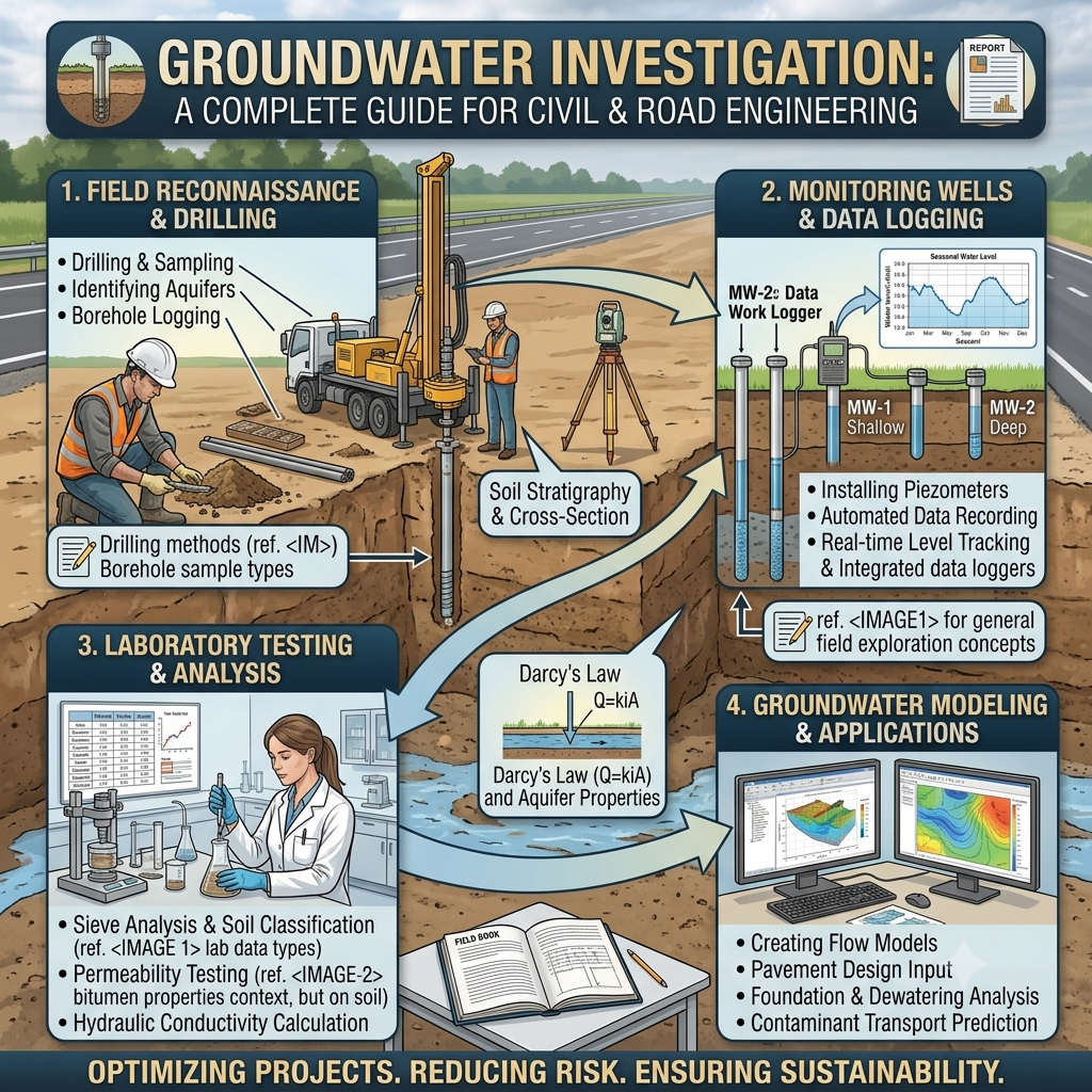
Introduction
Every successful civil engineering project begins with a thorough understanding of site conditions, and groundwater plays a major role in that assessment. Whether engineers plan a highway, bridge, building foundation, tunnel, retaining wall, or airport pavement, they must evaluate groundwater conditions before construction starts. A detailed Groundwater Investigation helps engineers identify the depth of the water table, groundwater movement, seasonal fluctuations, and water quality. This information directly influences foundation design, excavation methods, slope stability, pavement performance, and drainage planning.
Ignoring groundwater conditions can lead to excessive settlement, uplift pressure, soil instability, construction delays, and costly repairs. By carrying out a systematic groundwater investigation, engineers reduce project risks, improve safety, and extend the service life of infrastructure.
This guide explains the complete groundwater investigation process, engineering principles, field procedures, practical applications, and best practices for civil engineering projects.
What is Groundwater Investigation?
Groundwater Investigation is the systematic process of locating, measuring, analyzing, and evaluating groundwater beneath the Earth’s surface. Civil engineers perform this investigation to understand how groundwater will affect construction activities, structural foundations, pavement systems, and long-term infrastructure performance.
Groundwater exists within soil pores, rock fractures, and underground aquifers. Its depth and movement vary with rainfall, geology, seasonal conditions, and local topography.
Engineers study groundwater to answer several important questions:
- How deep is the groundwater table?
- Does groundwater fluctuate during different seasons?
- Will groundwater affect excavation?
- Can the soil safely support the proposed structure?
- Is dewatering required during construction?
- Does groundwater contain harmful chemicals?
The answers help engineers design safe, economical, and durable infrastructure.
Why Groundwater Investigation is Important
Groundwater significantly influences almost every construction project. A detailed investigation allows engineers to identify hidden risks before construction begins.
Key Benefits
- Improves foundation design
- Supports safe excavation
- Reduces construction risks
- Prevents excessive settlement
- Improves pavement performance
- Assists drainage design
- Protects underground structures
- Reduces long-term maintenance costs
Practical Example
Consider a highway project crossing a low-lying floodplain. If engineers ignore the high groundwater table, the pavement subgrade may become saturated during the rainy season. This can reduce soil strength, cause rutting, and shorten pavement life. A proper groundwater investigation allows engineers to raise the embankment, improve drainage, or stabilize the subgrade before construction begins.
Objectives of Groundwater Investigation
Every groundwater investigation has specific engineering objectives that support safe and efficient project execution.
Main Objectives
- Determine groundwater depth.
- Identify seasonal water table fluctuations.
- Evaluate groundwater flow direction.
- Assess aquifer characteristics.
- Determine soil permeability.
- Measure hydraulic conductivity.
- Evaluate groundwater quality.
- Support foundation selection.
- Design dewatering systems.
- Improve construction planning.
Achieving these objectives helps engineers make informed design decisions and avoid unexpected site problems.
Engineering Principles of Groundwater Investigation
Groundwater behaves according to well-established hydraulic and geotechnical principles. Understanding these concepts allows engineers to predict groundwater movement and its impact on construction.
Hydraulic Gradient
Groundwater naturally flows from areas of higher hydraulic head to lower hydraulic head. The hydraulic gradient controls the direction and speed of groundwater movement.
Darcy’s Law
Darcy’s Law forms the foundation of groundwater engineering. It states that groundwater flow depends on:
- Hydraulic gradient
- Soil permeability
- Cross-sectional flow area
Higher permeability allows groundwater to move more freely through soil or rock.
Soil Permeability
Different soils transmit groundwater at different rates.
| Soil Type | Relative Permeability |
|---|---|
| Gravel | Very High |
| Sand | High |
| Silty Sand | Moderate |
| Silt | Low |
| Clay | Very Low |
Understanding permeability helps engineers estimate seepage and design effective drainage systems.
Effective Stress Principle
Groundwater reduces the effective stress within soil. Lower effective stress decreases soil strength and may increase settlement or slope instability.
This principle plays a crucial role in foundation engineering and excavation design.
Groundwater Investigation Process
A successful groundwater investigation follows a systematic sequence. Each stage builds upon the information collected during the previous phase.
Step 1: Desk Study and Project Planning
Every investigation begins with collecting existing information about the project area.
Information Sources
- Geological maps
- Topographic maps
- Previous borehole records
- Hydrological reports
- Satellite imagery
- Rainfall records
- Groundwater databases
- Existing construction reports
Purpose
The desk study helps engineers:
- Understand regional geology.
- Identify potential groundwater problems.
- Plan field investigations.
- Select borehole locations.
- Estimate investigation costs.
Early planning improves investigation efficiency and reduces unnecessary field work.
Step 2: Site Reconnaissance
Site reconnaissance provides engineers with first-hand knowledge of field conditions before drilling begins.
Activities During Site Visit
- Observe natural drainage.
- Identify surface water bodies.
- Examine existing structures.
- Record vegetation patterns.
- Locate springs and wetlands.
- Identify signs of erosion.
- Assess site accessibility.
Why Site Reconnaissance Matters
Field observations often reveal conditions that maps and reports cannot show.
For example, unexpected seepage zones, abandoned wells, or poorly drained areas may influence the investigation program.
Step 3: Geological and Hydrogeological Survey
This stage examines the relationship between geological formations and groundwater occurrence.
Geological Survey
Engineers identify:
- Rock formations
- Soil layers
- Faults
- Fractures
- Weathered zones
Hydrogeological Survey
Hydrogeologists evaluate:
- Aquifer types
- Recharge areas
- Groundwater flow direction
- Existing wells
- Water table conditions
Practical Application
Suppose engineers identify fractured sandstone beneath a proposed bridge foundation. The fractures may carry significant groundwater flow, requiring foundation redesign or temporary dewatering during construction.
Step 4: Exploratory Drilling and Boreholes
Exploratory drilling provides direct information about subsurface conditions.
Engineers drill boreholes at carefully selected locations along the project alignment.
Borehole Objectives
- Identify soil layers.
- Measure groundwater depth.
- Collect soil samples.
- Collect groundwater samples.
- Install observation wells.
- Perform in-situ testing.
Common Drilling Methods
- Rotary drilling
- Auger drilling
- Percussion drilling
- Wash boring
The drilling method depends on soil type, project requirements, and groundwater conditions.
Field Records
Engineers document:
- Soil description
- Borehole depth
- Groundwater depth
- Sample locations
- Rock quality
- Drilling observations
Accurate borehole logs form the basis of engineering recommendations.
Step 5: Groundwater Level Monitoring
Measuring groundwater levels is one of the most important stages of the investigation.
Groundwater levels change due to:
- Rainfall
- Seasonal variations
- Nearby pumping
- River levels
- Construction activities
Therefore, engineers monitor groundwater over time rather than relying on a single measurement.
Monitoring Methods
- Observation wells
- Piezometers
- Automatic water level recorders
- Manual water level indicators
Information Collected
Monitoring provides data on:
- Static groundwater level
- Seasonal fluctuations
- Groundwater pressure
- Flow direction
- Long-term trends
This information supports excavation planning, foundation design, and dewatering strategies.
Groundwater Investigation Flow Diagram
Project Planning
        │
        ▼
Desk Study
        │
        ▼
Site Reconnaissance
        │
        ▼
Geological Survey
        │
        ▼
Exploratory Drilling
        │
        ▼
Groundwater Monitoring
        │
        ▼
Pumping Tests
        │
        ▼
Water Quality Testing
        │
        ▼
Engineering Analysis
        │
        ▼
Final Report
Field Example
A four-lane highway project crossed an area with soft clay and a shallow groundwater table. During the investigation, engineers installed observation wells and monitored groundwater levels over several months. The data revealed significant seasonal fluctuations caused by monsoon rainfall. Based on these findings, the design team increased embankment height, incorporated subsoil drainage, and stabilized the subgrade with lime treatment. These measures reduced the risk of pavement deformation, improved long-term performance, and minimized future maintenance costs.
Key Takeaways
A successful Groundwater Investigation begins with careful planning, detailed site reconnaissance, geological studies, exploratory drilling, and continuous groundwater monitoring. These early steps provide the essential data needed to evaluate subsurface conditions, identify construction risks, and develop safe engineering solutions. Accurate groundwater information improves foundation design, supports effective drainage planning, and enhances the durability of highways, bridges, and other civil engineering structures. Engineers who invest time in comprehensive groundwater investigations reduce project uncertainty, improve construction efficiency, and deliver more reliable infrastructure.
Step 6: Pumping Tests
After engineers determine the groundwater level, they perform pumping tests to evaluate the hydraulic properties of the aquifer. These tests reveal how groundwater responds to pumping and provide valuable data for designing dewatering systems, wells, and foundation drainage.
Objectives of Pumping Tests
- Measure aquifer yield.
- Determine hydraulic conductivity.
- Calculate transmissivity.
- Estimate storage coefficient.
- Evaluate groundwater recharge.
- Design temporary dewatering systems.
Pumping Test Procedure
- Install a pumping well.
- Position observation wells around the test well.
- Pump water at a constant discharge rate.
- Record groundwater level changes at regular intervals.
- Continue monitoring after pumping stops to observe recovery.
Engineering Applications
Pumping test results help engineers:
- Design deep excavations.
- Select dewatering equipment.
- Estimate pumping duration.
- Prevent excessive settlement around excavations.
- Assess long-term groundwater behavior.
Step 7: Groundwater Quality Testing
Groundwater quality affects the durability of foundations, concrete structures, steel reinforcement, pipelines, and underground utilities. Engineers analyze groundwater samples before finalizing material specifications and construction methods.
Common Water Quality Parameters
- pH value
- Chloride content
- Sulphate concentration
- Total dissolved solids (TDS)
- Hardness
- Iron content
- Electrical conductivity
- Alkalinity
Why Water Quality Matters
Aggressive groundwater may:
- Corrode reinforcing steel.
- Attack concrete.
- Damage buried pipelines.
- Reduce foundation durability.
- Increase maintenance costs.
Practical Example
If laboratory results indicate high sulphate concentrations, engineers may specify sulphate-resistant cement and additional protective measures for reinforced concrete foundations.
Step 8: Data Interpretation
Collecting field data alone does not complete a groundwater investigation. Engineers analyze and interpret the results to develop reliable design recommendations.
Data Analysis Includes
- Water table contour mapping.
- Groundwater flow direction.
- Seasonal groundwater fluctuations.
- Aquifer characteristics.
- Soil permeability evaluation.
- Foundation suitability.
- Excavation risks.
- Drainage requirements.
Engineering Decisions
Based on interpreted data, engineers decide:
- Foundation type
- Excavation support system
- Dewatering method
- Drainage design
- Soil improvement requirements
- Pavement drainage measures
Accurate interpretation transforms field measurements into practical engineering solutions.
Step 9: Engineering Recommendations
The investigation concludes with project-specific recommendations that guide designers and contractors throughout construction.
Typical Recommendations
- Foundation depth
- Suitable foundation system
- Ground improvement methods
- Dewatering requirements
- Drainage system design
- Waterproofing measures
- Construction sequencing
- Groundwater monitoring during construction
Common Ground Improvement Methods
- Lime stabilization
- Cement stabilization
- Stone columns
- Vibro compaction
- Geotextiles
- Geogrids
- Prefabricated vertical drains (PVD)
Selecting the appropriate method depends on soil conditions, groundwater behavior, and project requirements.
Step 10: Reporting and Documentation
The final stage involves preparing a comprehensive groundwater investigation report.
A well-prepared report communicates investigation findings clearly and supports informed engineering decisions.
Typical Report Contents
- Project overview
- Investigation objectives
- Site location
- Geological conditions
- Hydrogeological conditions
- Borehole logs
- Groundwater monitoring results
- Laboratory test results
- Pumping test analysis
- Water quality analysis
- Engineering recommendations
- Drawings and appendices
The report becomes a valuable reference throughout design, construction, and future maintenance.
Equipment Used in Groundwater Investigation
Field investigations require specialized equipment to obtain accurate and reliable data.
Common Equipment
- Rotary drilling rig
- Auger drilling machine
- Water level indicator
- Observation wells
- Piezometers
- Pumping test equipment
- GPS receiver
- Total Station
- Soil sampling tubes
- Groundwater sampling bottles
- Flow meters
- Data loggers
Proper calibration and maintenance of equipment improve the quality of collected data.
Common Challenges in Groundwater Investigation
Engineers frequently encounter challenges during field investigations.
Typical Problems
- Seasonal groundwater fluctuations.
- Difficult drilling conditions.
- Limited site accessibility.
- Contaminated groundwater.
- Variable geological formations.
- Incomplete historical records.
- Unexpected artesian pressure.
- Equipment failure.
Solutions
- Conduct investigations during different seasons.
- Increase the number of observation wells.
- Perform additional boreholes where required.
- Use experienced drilling contractors.
- Verify field data through laboratory testing.
- Maintain detailed field records.
Best Practices for Groundwater Investigation
Successful investigations follow proven engineering practices.
- Begin with a detailed desk study.
- Conduct comprehensive site reconnaissance.
- Select borehole locations carefully.
- Install observation wells for long-term monitoring.
- Perform pumping tests when groundwater influences design.
- Collect representative groundwater samples.
- Calibrate field equipment regularly.
- Verify laboratory results before finalizing recommendations.
- Coordinate geotechnical and hydrogeological investigations.
- Maintain complete documentation throughout the project.
Field Recommendations
Civil Engineers
- Review groundwater reports before completing foundation design.
- Consider seasonal groundwater variations rather than relying on a single reading.
- Integrate groundwater data with geotechnical investigations.
- Monitor groundwater during excavation.
Contractors
- Install dewatering systems before deep excavation.
- Inspect pumping equipment regularly.
- Protect boreholes from contamination.
- Maintain safe working conditions near excavation areas.
Engineering Students
- Learn how groundwater affects soil behavior.
- Understand Darcy’s Law and permeability concepts.
- Observe drilling operations during field visits.
- Practice interpreting borehole logs and groundwater monitoring data.
General Discussion of IRC, AASHTO, and ICE Practices
Leading engineering organizations such as the Indian Roads Congress (IRC), AASHTO, and the Institution of Civil Engineers (ICE) emphasize the importance of groundwater assessment during infrastructure development.
Their guidance generally recommends:
- Performing groundwater investigations during site exploration.
- Combining hydrogeological and geotechnical studies.
- Designing drainage systems based on field conditions.
- Evaluating groundwater effects on pavement foundations.
- Monitoring groundwater during construction.
- Considering groundwater fluctuations in long-term design.
- Using durable construction materials where aggressive groundwater exists.
- Maintaining quality assurance throughout investigation and construction.
Following these widely accepted engineering principles improves project safety, durability, and sustainability.
Groundwater Investigation Workflow Diagram
Project Planning
       │
       ▼
Desk Study
       │
       ▼
Site Survey
       │
       ▼
Borehole Drilling
       │
       ▼
Groundwater Monitoring
       │
       ▼
Pumping Test
       │
       ▼
Water Quality Testing
       │
       ▼
Engineering Analysis
       │
       ▼
Design Recommendations
       │
       ▼
Final Investigation Report
Frequently Asked Questions (FAQs)
1. What is the purpose of groundwater investigation?
Groundwater investigation identifies groundwater conditions that influence foundation design, excavation, drainage, pavement performance, and construction safety.
2. Why do engineers monitor groundwater levels over time?
Groundwater levels change with rainfall, seasons, pumping activities, and nearby water bodies. Long-term monitoring provides more reliable design data than a single measurement.
3. What is Darcy’s Law?
Darcy’s Law explains groundwater flow through porous materials by relating flow rate to hydraulic gradient, permeability, and cross-sectional area.
4. Which equipment is commonly used during groundwater investigations?
Engineers use drilling rigs, piezometers, observation wells, water level indicators, GPS equipment, flow meters, and groundwater sampling devices.
5. Why are pumping tests important?
Pumping tests determine aquifer properties, estimate groundwater yield, and help design efficient dewatering systems for construction projects.
6. How does groundwater affect highway construction?
High groundwater levels reduce soil strength, increase settlement risks, weaken pavement foundations, and complicate excavation activities.
7. Why is groundwater quality testing necessary?
Groundwater quality influences the durability of concrete, reinforcing steel, buried pipelines, and foundation materials.
8. What happens if groundwater investigation is ignored?
Ignoring groundwater conditions may lead to foundation failures, pavement distress, excavation collapse, excessive settlement, water seepage, and expensive repairs.
9. Which projects require groundwater investigations?
Highways, bridges, buildings, tunnels, retaining walls, airports, dams, industrial facilities, and underground structures all benefit from groundwater investigations.
10. How often should groundwater levels be monitored?
The monitoring period depends on project complexity, but engineers often collect data over several months to capture seasonal variations and establish reliable trends.
Conclusion
A comprehensive Groundwater Investigation forms the foundation of safe and successful civil engineering projects. From desk studies and site reconnaissance to drilling, groundwater monitoring, pumping tests, and laboratory analysis, every stage provides critical information for design and construction. Accurate groundwater data allows engineers to select suitable foundation systems, plan effective dewatering measures, improve drainage, and reduce long-term maintenance costs. It also minimizes construction risks, protects structural durability, and supports sustainable infrastructure development. Whether you work on highways, bridges, buildings, or underground structures, investing in a detailed Groundwater Investigation leads to better engineering decisions, improved project performance, and greater confidence throughout the entire construction lifecycle.

Kamran Malik is a passionate civil engineering writer and researcher who specializes in construction, transportation, structural engineering, and infrastructure topics. Through his articles on CivilEngineerings.com, he simplifies complex engineering concepts and shares practical insights, industry trends, and educational resources for students, professionals, and engineering enthusiasts.