
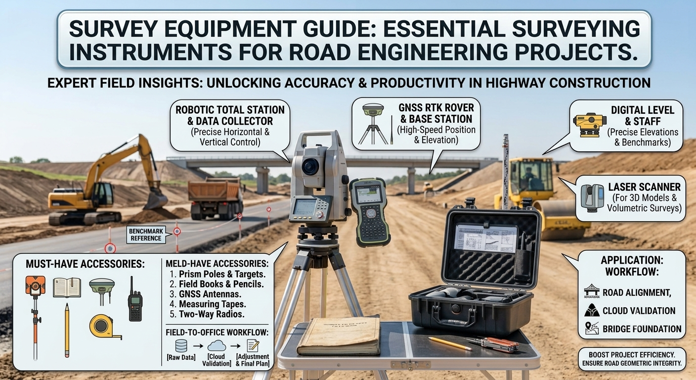
Introduction
Every successful road project begins with accurate field data. Engineers rely on precise measurements to design safe alignments, calculate earthwork, establish control points, and construct durable highways. A minor surveying error during the planning stage can lead to costly design revisions, construction delays, or structural problems. For this reason, surveying remains one of the most critical activities in civil and highway engineering.
This Survey Equipment Guide explains the most commonly used surveying instruments, their working principles, practical applications, advantages, and limitations. Whether you are a civil engineer, road contractor, surveyor, or engineering student, understanding the right equipment for each task improves project accuracy and efficiency.
Modern surveying combines traditional measuring tools with advanced digital technologies. While Total Stations, GPS receivers, drones, and laser scanners dominate today’s large-scale infrastructure projects, conventional instruments still play an important role during preliminary surveys, small construction works, and educational training.
By mastering the instruments discussed in this guide, professionals can reduce errors, improve productivity, and deliver road projects that meet quality standards and engineering specifications.
What is Survey Equipment?
Survey equipment includes the instruments and tools used to measure distances, elevations, angles, coordinates, and positions on the Earth’s surface. These measurements provide the data required for planning, designing, constructing, and maintaining transportation infrastructure.
In road engineering, survey equipment helps engineers establish the road centerline, determine existing ground levels, calculate cut-and-fill quantities, locate structures, and ensure that construction follows the approved design.
Without accurate surveying, engineers cannot produce reliable drawings, estimate quantities correctly, or maintain alignment throughout construction.
Why Survey Equipment is Important in Road Engineering
Road projects demand precise horizontal and vertical control. Survey equipment supplies the measurements required for every phase of highway development.
Key Benefits
- Produces accurate topographic maps.
- Establishes horizontal and vertical control points.
- Assists in route selection and highway alignment.
- Supports earthwork quantity calculations.
- Improves construction accuracy.
- Reduces costly field errors.
- Enhances project safety.
- Saves time and construction costs.
Practical Example
Before constructing a new highway, engineers perform a topographic survey to identify hills, valleys, rivers, existing roads, buildings, and utility lines. This information allows the design team to select the most economical and technically suitable alignment while minimizing environmental impacts.
Classification of Survey Equipment
Survey instruments can be grouped into three broad categories based on their primary function.
1. Distance Measuring Equipment
Used to determine horizontal or sloping distances.
Examples include:
- Steel tape
- Chain
- Measuring wheel
- Electronic Distance Measurement (EDM)
2. Angle Measuring Equipment
Measures horizontal and vertical angles.
Examples include:
- Surveyor’s compass
- Theodolite
- Total Station
3. Elevation Measuring Equipment
Determines height differences between points.
Examples include:
- Dumpy level
- Automatic level
- Digital level
- Leveling staff
Survey Equipment Guide
1. Chain and Steel Tape
The chain and steel tape are among the oldest surveying instruments. Although advanced electronic devices have replaced them in many applications, engineers still use them for simple measurements, small construction projects, and verification tasks.
Working Principle
The surveyor stretches the chain or tape between two points and records the measured distance.
Applications
- Property surveys
- Small road projects
- Building layout
- Site measurements
- Offset measurements
Advantages
- Simple operation
- Low cost
- No electrical power required
- Easy maintenance
Limitations
- Lower accuracy over long distances.
- Time-consuming.
- Sensitive to temperature and sag.
Simple Diagram
Point A ----------------------------- Point B
          Steel Tape / Chain
2. Measuring Wheel
A measuring wheel quickly measures long ground distances by counting wheel rotations.
It works well on roads, pavements, parking areas, and construction sites.
Working Principle
Each wheel rotation represents a known distance. A built-in mechanical or digital counter displays the total distance traveled.
Applications
- Road centerline measurement
- Sidewalk surveys
- Pavement inspection
- Utility layout
- Preliminary route surveys
Advantages
- Fast measurements
- Lightweight
- Easy to carry
- Simple operation
Limitations
- Reduced accuracy on rough terrain
- Wheel slippage affects measurements
Diagram
      Handle
        |
        |
       ( )
      /   \
-----O----- Road Surface
3. Surveyor’s Compass
A surveyor’s compass measures horizontal angles and bearings relative to magnetic north.
Although GPS and Total Stations have reduced its use, the compass remains valuable for reconnaissance surveys and educational purposes.
Working Principle
The magnetic needle aligns with Earth’s magnetic field. The surveyor reads the bearing of a selected line.
Applications
- Preliminary route surveys
- Forest surveys
- Boundary surveys
- Reconnaissance work
Advantages
- Portable
- Inexpensive
- Easy to use
- Quick field observations
Limitations
- Magnetic interference reduces accuracy.
- Unsuitable for high-precision engineering work.
Diagram
          N
          ↑
     W ← ○ → E
          ↓
          S
4. Dumpy Level
The dumpy level is a traditional optical instrument used to determine elevation differences between points.
It provides reliable leveling measurements when properly adjusted.
Main Components
- Telescope
- Spirit bubble
- Levelling screws
- Tripod stand
Applications
- Road profile surveys
- Bridge construction
- Building foundations
- Drainage works
Advantages
- Durable construction
- Stable measurements
- High accuracy
- Long service life
Limitations
- Manual leveling required
- Slower than automatic levels
Diagram
      Telescope
  -----------------
        |
      Tripod
      / | \
     /  |  \
5. Automatic Level
The automatic level has largely replaced the dumpy level on modern construction projects.
Its internal compensator automatically establishes a horizontal line of sight, reducing setup time and improving accuracy.
Working Principle
After rough leveling, the compensator automatically corrects small instrument tilts.
Applications
- Highway leveling
- Drainage construction
- Pavement elevation checks
- Earthwork control
- Bridge approaches
Advantages
- Faster setup
- High precision
- Easy operation
- Reduced human error
Limitations
- Sensitive to strong vibrations
- Requires periodic calibration
Diagram
      Automatic Level
       __________
      |          |
      | Telescope|
      |__________|
          ||
         Tripod
6. Leveling Staff
The leveling staff works together with a dumpy level or automatic level to measure elevation differences.
Graduations marked on the staff allow the surveyor to determine reduced levels accurately.
Types
- Folding staff
- Telescopic staff
- Fiberglass staff
- Aluminum staff
Applications
- Benchmarks
- Road leveling
- Culvert construction
- Earthwork measurement
- Drainage surveys
Advantages
- Lightweight
- Easy to transport
- Simple to read
- Compatible with most leveling instruments
Limitations
- Requires a second person during surveying.
- Wind can affect vertical positioning.
Diagram
      Level Staff
      |---------|
      |   4.0   |
      |   3.0   |
      |   2.0   |
      |   1.0   |
      |---------|
Engineering Tip
Always calibrate surveying equipment before starting fieldwork. Even a small measurement error can affect highway alignment, earthwork calculations, drainage gradients, and pavement construction. Regular maintenance, proper storage, and routine instrument checks help maintain measurement accuracy and improve project quality.
Key Takeaways
Selecting the right instrument is the first step toward accurate surveying and successful road construction. Traditional tools such as chains, steel tapes, measuring wheels, compasses, dumpy levels, automatic levels, and leveling staffs continue to play an important role in field surveys despite the availability of modern digital equipment. Each instrument serves a specific purpose, and engineers must understand its working principle, applications, advantages, and limitations before using it on a project. Accurate measurements at this stage create a strong foundation for reliable highway design, quantity estimation, and construction control.
7. Theodolite
The theodolite is a precision surveying instrument designed to measure horizontal and vertical angles with exceptional accuracy. Before the introduction of Total Stations, engineers relied heavily on theodolites for road alignment, bridge construction, and control surveys. Many engineering firms still use them for specialized applications and training.
Main Components
- Telescope
- Horizontal circle
- Vertical circle
- Vernier or digital display
- Levelling screws
- Tripod stand
Working Principle
The surveyor levels the instrument over a control point, sights the target through the telescope, and records the required horizontal and vertical angles.
Practical Applications
- Highway alignment
- Bridge layout
- Tunnel construction
- Curve setting
- Building construction
- Control surveys
Advantages
- High angular accuracy
- Reliable measurements
- Suitable for engineering projects
- Durable construction
Limitations
- Measures angles only unless paired with EDM equipment
- Requires skilled operation
- Takes longer than a Total Station
Diagram
                 Telescope
      =========================
             |         |
      Horizontal Circle
             |
          Tripod
         /  |  \
8. Total Station
The Total Station has transformed modern surveying by combining an electronic theodolite, Electronic Distance Measurement (EDM), onboard computer, and data storage into one instrument.
Today, most highway projects depend on Total Stations because they deliver fast, accurate, and efficient measurements.
Working Principle
The instrument emits an infrared or laser beam toward a prism or reflector. It measures the distance electronically while simultaneously recording horizontal and vertical angles. The onboard computer calculates coordinates automatically.
Practical Applications
- Highway centerline setting
- Topographic surveys
- Construction layout
- Earthwork calculations
- Bridge positioning
- Utility mapping
Advantages
- High accuracy
- Fast data collection
- Digital storage
- Reduced human error
- Easy transfer of survey data to CAD software
Limitations
- Higher purchase cost
- Requires regular calibration
- Performance may reduce during heavy rain or fog
Diagram
        Total Station
      ________________
     |   Display      |
     |    Telescope   |
     |________________|
            ||
         Tripod
            ||
           Prism
9. GPS/GNSS Survey Equipment
Global Navigation Satellite System (GNSS) technology enables surveyors to determine precise coordinates without measuring every distance manually. Modern highway projects use GPS and GNSS equipment for route selection, control surveys, and large-area mapping.
Working Principle
The receiver communicates with multiple satellites to calculate its exact position using satellite signals.
Applications
- Highway corridor surveys
- Control point establishment
- Land acquisition surveys
- GIS mapping
- Route planning
- Infrastructure monitoring
Advantages
- Covers large areas quickly
- High positional accuracy with RTK systems
- Reduces field time
- Works efficiently in open environments
Limitations
- Signal obstruction near buildings, forests, or mountains
- Performance depends on satellite visibility
- Requires trained operators
Diagram
      Satellite
          *
         / \
        /   \
      GPS Receiver
          |
      Survey Point
10. Digital Level
A digital level improves the accuracy and speed of leveling operations by replacing manual staff readings with electronic measurements.
The instrument automatically reads a barcode leveling staff and stores measurements digitally.
Applications
- Highway leveling
- Bridge construction
- Settlement monitoring
- Railway surveys
- Dam construction
Advantages
- Very high accuracy
- Eliminates reading errors
- Faster operation
- Automatic data recording
Limitations
- Higher cost
- Requires barcode staff
- Needs battery power
Diagram
      Digital Level
     ______________
    | LCD Display |
    |_____________|
          ||
        Tripod
          ||
      Barcode Staff
11. Drone Surveying (UAV)
Drone surveying has become one of the most innovative technologies in highway engineering. Unmanned Aerial Vehicles (UAVs) capture high-resolution images and generate accurate three-dimensional terrain models in a fraction of the time required by traditional surveys.
Working Principle
The drone flies over the survey area following a programmed flight path. Cameras capture overlapping photographs that specialized software converts into orthophotos, digital elevation models, and 3D point clouds.
Applications
- Route selection
- Topographic mapping
- Earthwork monitoring
- Construction progress tracking
- Quarry surveys
- Environmental assessments
Advantages
- Rapid data collection
- Excellent coverage
- Improved safety
- Reduced manpower
- High-quality aerial imagery
Limitations
- Weather dependent
- Flight regulations apply
- Battery limitations
Diagram
        Drone
      \  |  /
       \ | /
        \|/
   Aerial Photography
         ↓
      Highway Site
12. Laser Scanner (LiDAR)
Light Detection and Ranging (LiDAR) represents one of the most advanced surveying technologies available today. It creates millions of measurement points within minutes, producing highly accurate three-dimensional models.
Working Principle
The scanner emits laser pulses toward surrounding objects and measures the time required for the reflected signals to return. The instrument converts these measurements into a dense point cloud.
Applications
- Highway corridor mapping
- Bridge inspection
- Tunnel surveys
- Slope monitoring
- Digital terrain modeling
- Asset management
Advantages
- Extremely accurate
- Very fast data collection
- Detailed 3D models
- Suitable for complex terrain
Limitations
- Expensive equipment
- Large data processing requirements
- Requires specialized software
Diagram
      LiDAR Scanner
            *
          / | \
        /   |   \
   Millions of Laser Points
             ↓
        3D Terrain Model
Best Practices for Using Survey Equipment
Following good surveying practices improves measurement quality and reduces costly construction errors.
Recommended Practices
- Calibrate instruments before every major project.
- Protect equipment from dust, moisture, and vibration.
- Verify control points before beginning fieldwork.
- Record observations systematically.
- Use appropriate equipment for the required accuracy.
- Perform regular maintenance according to manufacturer guidelines.
- Check instrument leveling frequently during surveys.
- Back up digital survey data after each field session.
- Train operators on modern surveying technologies.
- Follow project specifications and quality assurance procedures.
Common Surveying Mistakes to Avoid
Avoiding these common errors can improve project accuracy and reduce rework.
- Ignoring instrument calibration
- Incorrect tripod setup
- Poor centering over survey points
- Recording incorrect field notes
- Using damaged measuring equipment
- Neglecting weather conditions
- Failing to verify benchmark elevations
- Skipping equipment maintenance
- Relying on a single measurement without verification
- Improper data transfer to design software
Practical Recommendations
Civil Engineers
- Select survey equipment based on project accuracy requirements.
- Verify field data before preparing design drawings.
- Integrate survey information with GIS and CAD software.
- Schedule periodic calibration of all precision instruments.
Contractors
- Protect survey control points during construction.
- Confirm layout coordinates before excavation.
- Train field personnel in proper instrument handling.
- Maintain backup copies of digital survey records.
Engineering Students
- Learn both conventional and modern surveying techniques.
- Practice field measurements regularly.
- Understand the limitations of each instrument.
- Gain experience with Total Stations, GPS, and drone mapping software.
General Discussion of IRC, AASHTO, and ICE Practices
Highway engineering organizations such as the Indian Roads Congress (IRC), the American Association of State Highway and Transportation Officials (AASHTO), and the Institution of Civil Engineers (ICE) emphasize accurate surveying as the foundation of successful infrastructure projects.
Their guidance generally encourages engineers to:
- Establish reliable horizontal and vertical control networks.
- Perform comprehensive topographic and geotechnical surveys before design.
- Use calibrated instruments that meet project accuracy requirements.
- Maintain detailed survey documentation and field records.
- Verify measurements through independent checks where appropriate.
- Integrate modern surveying technologies with established engineering procedures.
- Follow quality assurance protocols throughout planning and construction.
These practices help deliver safer, more economical, and more durable road infrastructure.
Frequently Asked Questions (FAQs)
1. What is the most commonly used survey instrument in modern road construction?
The Total Station is the most widely used instrument because it measures angles, distances, and coordinates with high accuracy while storing digital data.
2. Why is surveying important before highway construction?
Surveying provides accurate information about terrain, elevations, boundaries, utilities, and existing features, allowing engineers to design safe and economical highways.
3. What is the difference between a theodolite and a Total Station?
A theodolite primarily measures angles, whereas a Total Station combines angle measurement, electronic distance measurement, coordinate calculation, and digital data storage in one instrument.
4. When should engineers use GPS or GNSS equipment?
GPS/GNSS equipment is ideal for large-scale control surveys, corridor mapping, route selection, and establishing accurate geographic coordinates.
5. Why do engineers still use leveling staffs?
Leveling staffs remain essential because they work with optical and digital levels to determine accurate elevation differences during construction.
6. How do drones improve highway surveys?
Drones collect aerial images quickly, improve safety, reduce field time, and generate accurate topographic maps and three-dimensional terrain models.
7. What factors affect survey accuracy?
Instrument calibration, operator skill, weather conditions, control point quality, proper setup, and regular verification all influence survey accuracy.
8. Which survey equipment is best for beginners?
Engineering students often begin with chains, steel tapes, automatic levels, leveling staffs, and compasses before progressing to Total Stations and GPS systems.
9. How often should survey equipment be calibrated?
Precision instruments should undergo calibration according to manufacturer recommendations and before major projects or whenever measurement accuracy becomes questionable.
10. What safety precautions should surveyors follow on road projects?
Surveyors should wear high-visibility clothing, use traffic control measures, communicate with construction teams, and avoid working in active traffic lanes without proper protection.
Conclusion
Accurate surveying forms the backbone of every successful transportation project, making a comprehensive Survey Equipment Guide essential for engineers, contractors, and students alike. From traditional tools such as chains, steel tapes, and leveling instruments to advanced technologies like Total Stations, GPS/GNSS receivers, drones, and LiDAR scanners, each instrument serves a specific purpose in collecting reliable field data. Selecting the appropriate equipment, maintaining regular calibration, and following proven surveying procedures improve measurement accuracy, reduce construction errors, and enhance project efficiency. As road engineering continues to adopt digital technologies, professionals who understand both conventional and modern surveying methods will remain better prepared to deliver safe, economical, and sustainable infrastructure. By applying the knowledge shared in this Survey Equipment Guide, you can improve field productivity, strengthen engineering decisions, and contribute to the successful planning, design, and construction of high-quality road projects.

Kamran Malik is a passionate civil engineering writer and researcher who specializes in construction, transportation, structural engineering, and infrastructure topics. Through his articles on CivilEngineerings.com, he simplifies complex engineering concepts and shares practical insights, industry trends, and educational resources for students, professionals, and engineering enthusiasts.