
Introduction
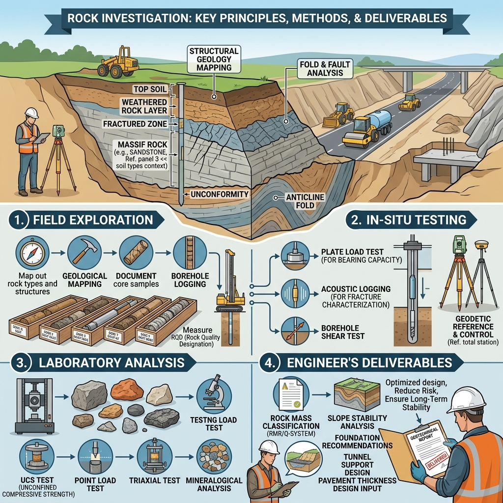
Every successful civil engineering project begins with a clear understanding of the ground conditions beneath the proposed structure. While soil investigation receives significant attention, engineers must also evaluate rock formations whenever foundations, highways, tunnels, dams, bridges, retaining walls, or deep excavations interact with bedrock. A thorough Rock Investigation helps engineers identify the strength, quality, weathering, discontinuities, and engineering behavior of rock masses before construction starts.
In road and highway engineering, rock investigation plays a crucial role during route selection, cutting design, slope stabilization, tunnel construction, bridge foundation design, and quarry material evaluation. Ignoring rock conditions can lead to unstable slopes, excessive excavation costs, foundation failures, water seepage, and construction delays.
This comprehensive guide explains the principles, methods, field procedures, engineering applications, and best practices of Rock Investigation using practical examples and modern engineering concepts. Whether you are a civil engineer, road engineer, contractor, consultant, or engineering student, understanding rock investigation will help you design safer, stronger, and more economical infrastructure.
What is Rock Investigation?
Rock Investigation is the systematic process of studying rock formations to determine their physical, mechanical, geological, and engineering properties before designing or constructing infrastructure.
Unlike soil investigations, rock investigations focus on understanding the characteristics of intact rock and the rock mass as a whole. Engineers examine rock type, weathering, fractures, joints, bedding planes, groundwater conditions, and strength parameters to assess whether the rock can safely support engineering structures.
Engineering Definition
Rock Investigation is the collection, analysis, and interpretation of geological and engineering data related to rock formations for the planning, design, and construction of civil engineering projects.
Common Applications
- Highway construction
- Tunnel projects
- Bridge foundations
- Dam construction
- High-rise buildings
- Deep excavations
- Quarry development
- Slope stabilization
- Retaining structures
- Underground utilities
Objectives of Rock Investigation
Every investigation aims to reduce uncertainty before construction begins.
Primary Objectives
- Identify rock types along the project alignment.
- Determine rock strength and durability.
- Locate faults, joints, and fractures.
- Assess groundwater conditions.
- Evaluate excavation difficulty.
- Estimate blasting requirements.
- Design safe foundations.
- Analyze slope stability.
- Classify rock masses.
- Recommend suitable construction methods.
A detailed investigation allows engineers to make informed decisions during design and construction while reducing project risks.
Importance of Rock Investigation in Civil and Road Engineering
Rock conditions directly influence construction costs, project safety, and long-term structural performance.
For example, when a highway passes through mountainous terrain, engineers must determine whether the rock slopes remain stable after excavation. Similarly, bridge foundations require strong and competent rock to safely transfer structural loads.
Benefits of Rock Investigation
- Improves foundation design.
- Reduces construction uncertainty.
- Prevents unexpected excavation problems.
- Supports accurate cost estimation.
- Enhances slope stability.
- Minimizes project delays.
- Improves long-term durability.
- Increases construction safety.
Practical Example
Consider a highway project that crosses a rocky hillside. During the investigation, engineers discover highly weathered shale with closely spaced joints. Instead of designing steep cut slopes, they revise the slope angle, install rock bolts, and provide drainage measures. This proactive approach reduces the risk of landslides and ensures long-term stability.
Engineering Geology Fundamentals
Engineering geology provides the scientific foundation for rock investigation. It explains how geological processes influence the engineering behavior of rocks.
Factors That Influence Rock Performance
- Mineral composition
- Rock origin
- Degree of weathering
- Joint spacing
- Fault zones
- Groundwater conditions
- Stress history
- Discontinuity orientation
Understanding these factors helps engineers predict how the rock will behave during excavation and throughout the service life of the structure.
Types of Rock Formations
Engineers generally classify rocks into three major groups based on their origin.
Igneous Rocks
Igneous rocks form when molten magma cools and solidifies.
Examples
- Granite
- Basalt
- Diorite
- Gabbro
Engineering Characteristics
- High compressive strength
- Excellent durability
- Low permeability
- Suitable for heavy foundations and road aggregates
Sedimentary Rocks
Sedimentary rocks develop through the deposition and compaction of sediments.
Examples
- Sandstone
- Limestone
- Shale
- Conglomerate
Engineering Characteristics
- Variable strength
- Layered structure
- May contain weak bedding planes
- Performance depends on cementation and weathering
Metamorphic Rocks
Metamorphic rocks form when existing rocks undergo high pressure and temperature.
Examples
- Marble
- Quartzite
- Slate
- Schist
- Gneiss
Engineering Characteristics
- High strength in many cases
- Strong foliation may influence stability
- Excellent durability when intact
Selecting the appropriate construction method depends heavily on the type and condition of the encountered rock.
Rock Investigation Process Step by Step
A systematic investigation produces reliable engineering data and minimizes construction risks.
Step 1: Desk Study and Geological Review
Every rock investigation begins with collecting existing information about the project area.
Sources of Information
- Geological maps
- Satellite imagery
- Topographic maps
- Previous investigation reports
- Academic publications
- Government geological databases
- Aerial photographs
Objectives
- Understand regional geology.
- Identify major fault systems.
- Locate historical landslides.
- Estimate expected rock formations.
- Plan field investigations efficiently.
A well-prepared desk study saves time and reduces unnecessary fieldwork.
Step 2: Site Reconnaissance
Engineers then visit the project site to verify information gathered during the desk study.
Activities
- Observe natural rock exposures.
- Identify weathering patterns.
- Record groundwater seepage.
- Examine existing cut slopes.
- Locate unstable rock masses.
- Photograph geological features.
Practical Importance
Field observations often reveal conditions that maps cannot show, such as fresh rock exposures, unstable cliffs, or hidden drainage channels.
Step 3: Geological Mapping
Geological mapping documents the distribution and characteristics of rock formations across the project site.
Information Recorded
- Rock type
- Bedding orientation
- Joint sets
- Fault locations
- Fold structures
- Weathering grade
- Fracture density
- Surface drainage
Field Equipment
- Geological compass
- GPS receiver
- Measuring tape
- Geological hammer
- Field notebook
- Digital camera
- Drone (where applicable)
Accurate geological mapping forms the basis for safe engineering design.
Step 4: Surface Rock Examination
Engineers carefully inspect exposed rock surfaces to evaluate their engineering properties before drilling begins.
Features Examined
- Color
- Texture
- Grain size
- Weathering
- Joint spacing
- Joint persistence
- Joint aperture
- Roughness
- Water seepage
Engineering Observations
During surface inspections, engineers also assess:
- Potential rockfall hazards
- Slope instability
- Signs of previous failures
- Weathered zones
- Structural discontinuities
These observations guide the selection of borehole locations and testing programs.
Step 5: Preliminary Sampling
After identifying representative rock exposures, engineers collect samples for laboratory testing.
Sampling Methods
- Block samples
- Core samples (where available)
- Grab samples
- Channel samples
Sampling Objectives
- Determine rock strength.
- Evaluate mineral composition.
- Assess durability.
- Measure density.
- Identify weathering effects.
Proper labeling and preservation of samples ensure reliable laboratory results.
Rock Investigation Workflow Diagram
Project Planning
       │
       ▼
Desk Study
       │
       ▼
Site Reconnaissance
       │
       ▼
Geological Mapping
       │
       ▼
Surface Rock Examination
       │
       ▼
Preliminary Sampling
       │
       ▼
Borehole Investigation
       │
       ▼
Field & Laboratory Testing
       │
       ▼
Engineering Analysis
       │
       ▼
Final Rock Investigation Report
Key Takeaways
A successful Rock Investigation begins with careful planning, geological research, field reconnaissance, and systematic examination of rock formations. Understanding rock types, discontinuities, weathering, and structural features allows engineers to select appropriate investigation methods and prepare for detailed testing. These early stages reduce uncertainty, improve design accuracy, and help prevent costly construction issues. By following a structured investigation process, engineers can make informed decisions that enhance the safety, durability, and economic performance of civil and road engineering projects.
Step 6: Borehole Investigation
After completing the preliminary field assessment, engineers begin borehole drilling to examine subsurface rock conditions. Boreholes provide direct information about the depth, continuity, and quality of rock layers that remain hidden beneath the ground surface.
Engineers carefully select borehole locations based on geological mapping, project layout, and structural requirements.
Objectives of Borehole Investigation
- Determine rock depth.
- Identify weathered and fresh rock zones.
- Measure groundwater levels.
- Recover rock cores for laboratory testing.
- Detect faults, fractures, and cavities.
- Confirm geological interpretations.
Common Drilling Methods
- Diamond Core Drilling
- Rotary Drilling
- Percussion Drilling
- Reverse Circulation Drilling
Diamond core drilling remains the preferred method for civil engineering projects because it produces continuous rock cores with minimal disturbance.
Core Recovery
Engineers evaluate:
- Core Recovery Percentage (CR)
- Rock Quality Designation (RQD)
- Core condition
- Fracture frequency
- Weathering changes
High-quality core recovery provides reliable engineering information and improves design confidence.
Step 7: Field Testing
Field testing determines the in-situ properties of rock masses before excavation begins.
Unlike laboratory tests, field tests evaluate rock behavior under actual site conditions.
Common Field Tests
Point Load Strength Test
Engineers estimate rock strength quickly in the field.
Applications include:
- Preliminary foundation design
- Tunnel projects
- Quarry investigations
Schmidt Rebound Hammer Test
This non-destructive test estimates surface hardness and compressive strength.
Benefits include:
- Rapid testing
- Portable equipment
- Immediate results
Permeability Test
Engineers determine the movement of groundwater through fractured rock.
Typical applications include:
- Dam foundations
- Tunnel projects
- Deep excavations
Plate Load Test
This test evaluates the bearing capacity and deformation characteristics of rock foundations under applied loads.
Discontinuity Survey
Engineers measure:
- Joint spacing
- Joint orientation
- Joint persistence
- Roughness
- Aperture
- Infilling materials
Discontinuities often control rock mass behavior more than the intact rock itself.
Step 8: Laboratory Testing
Laboratory testing provides accurate engineering parameters required for structural and geotechnical design.
Common Laboratory Tests
Unconfined Compressive Strength (UCS)
Determines the maximum compressive strength of intact rock.
Applications:
- Foundation design
- Tunnel support
- Pavement design
- Rock excavation planning
Brazilian Tensile Strength Test
Measures indirect tensile strength.
Engineers use these results to assess crack initiation and propagation.
Triaxial Compression Test
Determines:
- Cohesion
- Friction angle
- Failure envelope
- Rock deformation
Slake Durability Test
Evaluates resistance to repeated wetting and drying.
This test is especially important for shale and other weak sedimentary rocks.
Density and Water Absorption Test
These tests determine:
- Bulk density
- Specific gravity
- Porosity
- Water absorption
These parameters influence durability and material selection.
Step 9: Rock Mass Classification
Engineers classify rock masses to simplify design and construction decisions.
Classification systems combine geological observations with laboratory and field test results.
Rock Quality Designation (RQD)
RQD measures rock quality using recovered drill cores.
General Classification
- 90–100% = Excellent
- 75–90% = Good
- 50–75% = Fair
- 25–50% = Poor
- Below 25% = Very Poor
Higher RQD values generally indicate stronger and less fractured rock masses.
Rock Mass Rating (RMR)
The RMR system evaluates:
- UCS
- RQD
- Joint spacing
- Joint condition
- Groundwater
- Joint orientation
Engineers commonly use RMR for:
- Tunnel support design
- Slope stability assessment
- Foundation engineering
Q-System
The Q-System considers:
- Rock quality
- Joint roughness
- Joint alteration
- Water conditions
- Stress environment
This system assists engineers in selecting tunnel support systems.
Geological Strength Index (GSI)
GSI estimates rock mass strength based on:
- Rock structure
- Surface conditions
- Degree of weathering
Engineers often combine GSI with numerical modeling for advanced rock engineering analysis.
Step 10: Engineering Evaluation and Reporting
After completing fieldwork and laboratory testing, engineers analyze all collected data and prepare a comprehensive rock investigation report.
This report becomes one of the most important technical documents for the design team.
Typical Report Contents
- Project overview
- Geological setting
- Investigation methods
- Borehole logs
- Geological maps
- Laboratory results
- Rock mass classifications
- Groundwater observations
- Engineering interpretation
- Design recommendations
Design Recommendations May Include
- Foundation type
- Excavation method
- Slope stabilization
- Blasting requirements
- Drainage measures
- Rock reinforcement
- Construction precautions
A well-prepared report minimizes uncertainty and supports informed engineering decisions.
Equipment Used in Rock Investigation
Modern investigations rely on specialized equipment to improve data accuracy and efficiency.
Common Equipment
- Geological hammer
- Brunton compass
- GPS receiver
- Drone
- Total Station
- Diamond core drilling rig
- Core boxes
- Borehole camera
- Schmidt hammer
- Point load testing machine
- Digital calipers
- Water level indicator
Using calibrated equipment ensures reliable and repeatable results.
Practical Field Recommendations
Civil Engineers
- Review geological maps before site visits.
- Verify borehole locations with survey data.
- Examine discontinuities carefully.
- Correlate laboratory results with field observations.
- Document groundwater conditions throughout the investigation.
Contractors
- Protect exposed rock faces from unnecessary blasting.
- Store rock cores properly.
- Follow approved drilling procedures.
- Maintain drilling equipment regularly.
- Report unexpected geological conditions immediately.
Engineering Students
- Learn to identify common rock types in the field.
- Practice geological mapping techniques.
- Understand rock mass classification systems.
- Visit construction sites involving tunnels, dams, or highway cuttings.
- Develop strong observation and documentation skills.
Best Practices for Rock Investigation
- Begin every project with a detailed desk study.
- Conduct thorough geological mapping before drilling.
- Drill sufficient boreholes to represent site conditions.
- Recover high-quality rock cores.
- Perform both field and laboratory testing.
- Use internationally accepted rock classification systems.
- Integrate geological, geotechnical, and structural information.
- Maintain detailed field records and photographs.
- Review investigation findings throughout the design process.
- Update the geological model if new conditions appear during construction.
Common Mistakes to Avoid
- Relying on too few boreholes.
- Ignoring weathered rock zones.
- Misinterpreting joint orientation.
- Overlooking groundwater conditions.
- Using laboratory results without field verification.
- Inadequate documentation of geological features.
- Failing to classify rock masses correctly.
- Ignoring unexpected conditions during excavation.
Avoiding these mistakes improves project safety, reduces construction risks, and prevents costly design changes.
General Discussion of IRC, AASHTO, and ICE Practices
Leading engineering organizations such as the Indian Roads Congress (IRC), AASHTO, and the Institution of Civil Engineers (ICE) emphasize the importance of comprehensive site investigations before beginning major infrastructure projects.
Their general guidance encourages engineers to:
- Complete geological and geotechnical investigations during the planning stage.
- Base foundation and pavement designs on verified field data.
- Evaluate rock quality, groundwater conditions, and discontinuities before excavation.
- Use recognized classification systems such as RQD and RMR where appropriate.
- Perform quality assurance throughout the investigation process.
- Maintain complete investigation records to support future maintenance and rehabilitation.
Following these established engineering principles improves project reliability and supports informed decision making.
Frequently Asked Questions (FAQs)
1. What is Rock Investigation in civil engineering?
Rock Investigation is the process of studying rock formations to determine their engineering properties, strength, discontinuities, weathering, and suitability for construction projects.
2. Why is Rock Investigation important before highway construction?
It helps engineers design safe foundations, stable cut slopes, tunnels, retaining structures, and pavement systems while reducing construction risks.
3. Which drilling method is commonly used for Rock Investigation?
Diamond core drilling is the most widely used method because it produces continuous, high-quality rock cores for detailed evaluation.
4. What is Rock Quality Designation (RQD)?
RQD measures the quality of a rock mass based on the percentage of sound drill core pieces longer than 100 mm recovered from a borehole.
5. What does Rock Mass Rating (RMR) evaluate?
RMR evaluates intact rock strength, RQD, joint spacing, joint condition, groundwater conditions, and joint orientation to classify the rock mass.
6. Which laboratory tests are commonly performed on rock samples?
Common tests include Unconfined Compressive Strength (UCS), Brazilian Tensile Strength, Triaxial Compression, Slake Durability, Density, and Water Absorption tests.
7. How does groundwater affect rock engineering?
Groundwater reduces effective strength, increases weathering, weakens discontinuities, and may cause instability in slopes, tunnels, and foundations.
8. What equipment is essential for a Rock Investigation?
Essential equipment includes drilling rigs, geological hammers, GPS units, Brunton compasses, Schmidt hammers, point load testing machines, borehole cameras, and surveying instruments.
9. Which projects require Rock Investigation?
Highways, bridges, tunnels, dams, retaining walls, high-rise buildings, hydropower projects, underground structures, and quarry developments all require detailed rock investigations.
10. How does Rock Investigation improve construction safety?
It identifies geological hazards before construction, allowing engineers to select appropriate excavation methods, support systems, drainage measures, and foundation designs.
Conclusion
A comprehensive Rock Investigation forms the backbone of safe and economical civil engineering design. From desk studies and geological mapping to borehole drilling, laboratory testing, and rock mass classification, every stage provides essential information about the behavior of the underlying rock. Engineers use this data to design stable foundations, safe slopes, durable highways, reliable tunnels, and long-lasting infrastructure. Careful investigation also reduces construction risks, controls project costs, and minimizes unexpected site problems. Whether you are planning a highway, bridge, dam, or commercial building, investing time and resources in a detailed Rock Investigation ensures better engineering decisions and stronger project outcomes. Combining field observations with laboratory analysis and internationally recognized engineering practices creates infrastructure that performs safely and efficiently throughout its design life.
