
Introduction
Developing highways, railways, airports, dams, industrial parks, and urban infrastructure often requires land that is privately or publicly owned. Before construction can begin, the project authority must legally obtain the required land while protecting the rights of affected landowners. This structured procedure is known as the Land Acquisition Process.
For transportation engineers and project managers, land acquisition is much more than a legal formality. It directly influences project schedules, construction costs, environmental compliance, and community acceptance. Delays in acquiring land can postpone entire infrastructure projects, increase budgets, and create disputes among stakeholders.
A successful land acquisition strategy balances engineering requirements with legal obligations, fair compensation, environmental considerations, and social responsibility. Whether you are a civil engineer, contractor, engineering student, or government official, understanding each stage of the process is essential for effective project planning.
This guide explains the Land Acquisition Process in detail, covering its objectives, legal framework, engineering principles, practical applications, and the major steps followed in road and highway projects.
What Is the Land Acquisition Process?
The Land Acquisition Process is the legal and administrative procedure through which land is obtained for projects that serve a public purpose. These projects may include highways, expressways, bridges, rail corridors, airports, irrigation systems, utility networks, and urban development schemes.
The process generally involves:
- Identifying the required land
- Conducting technical and legal surveys
- Verifying ownership records
- Assessing land value
- Determining fair compensation
- Consulting affected stakeholders
- Completing legal transfer of ownership
- Handing over possession for construction
A transparent acquisition process helps minimize disputes while ensuring that project development proceeds in accordance with applicable laws and ethical standards.
Why Is Land Acquisition Important?
Infrastructure projects cannot proceed without adequate land. Proper acquisition ensures that construction activities are carried out on legally transferred property while protecting the interests of both project authorities and landowners.
Key benefits include:
- Enables timely project implementation.
- Reduces legal disputes during construction.
- Ensures fair compensation for affected owners.
- Supports planned urban and regional development.
- Facilitates long-term transportation improvements.
- Protects public investment by reducing project delays.
For major highway developments, land acquisition often represents a significant portion of the total project budget. Effective planning at this stage can prevent costly redesigns and schedule overruns.
Objectives of the Land Acquisition Process
The primary goal is to obtain land required for public infrastructure while balancing development needs with social equity and legal compliance.
Specific objectives include:
- Acquire sufficient land for the proposed project.
- Ensure transparency throughout the acquisition procedure.
- Provide equitable compensation to affected landowners.
- Minimize displacement wherever possible.
- Reduce environmental and social impacts.
- Maintain compliance with applicable laws and regulations.
- Support sustainable infrastructure development.
These objectives promote public confidence and improve the overall success of infrastructure projects.
Legal and Engineering Framework
Land acquisition combines legal procedures with engineering analysis. Engineers determine how much land is needed, while government authorities ensure that acquisition follows statutory requirements.
Government Authority
Most countries empower designated government agencies to acquire land for projects that serve a recognized public purpose. The exact procedure varies by jurisdiction but generally includes notifications, surveys, valuation, compensation, and transfer of ownership.
Authorities are typically responsible for:
- Issuing acquisition notifications.
- Maintaining land records.
- Conducting ownership verification.
- Determining compensation.
- Resolving legal disputes.
- Facilitating possession and transfer.
Engineering Planning
Before acquiring land, engineers evaluate the technical feasibility of the proposed project.
Typical engineering activities include:
- Route alignment studies
- Topographic surveys
- Geotechnical investigations
- Traffic demand analysis
- Utility mapping
- Environmental assessments
These studies help optimize the alignment, minimize land requirements, and reduce future construction challenges.
Social and Environmental Considerations
Modern infrastructure planning extends beyond engineering design. Social and environmental factors play a critical role in determining project feasibility and public acceptance.
Important considerations include:
- Effects on local communities
- Relocation of affected households
- Protection of agricultural land
- Preservation of cultural heritage
- Conservation of environmentally sensitive areas
- Livelihood restoration for displaced persons
Early stakeholder engagement can reduce opposition and improve project outcomes.
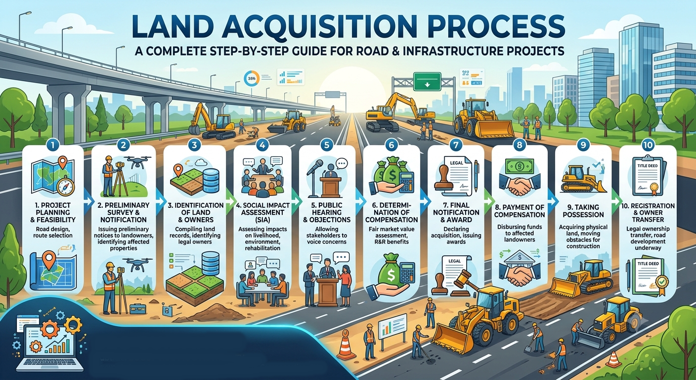
Step-by-Step Land Acquisition Process
Although procedures differ across countries, most infrastructure projects follow a similar sequence.
Step 1: Project Planning and Feasibility Study
Every acquisition process begins with identifying the need for a new infrastructure project.
Engineers and planners assess:
- Existing transportation conditions
- Future traffic demand
- Economic benefits
- Technical feasibility
- Environmental constraints
- Financial viability
For example, if a national highway experiences severe congestion, planners may recommend widening the roadway or constructing a bypass. Both options require determining the amount of additional land needed.
A comprehensive feasibility study ensures that land acquisition is justified and supports the project’s long-term objectives.
Step 2: Identification of Land Requirements
Once the preferred project alignment is selected, engineers estimate the total land required.
This stage involves defining:
- Right-of-way (ROW)
- Construction zones
- Utility corridors
- Drainage facilities
- Service roads
- Intersections
- Future expansion areas
Accurate estimation prevents unnecessary acquisition while ensuring adequate space for safe and efficient infrastructure.
Practical Example
For a four-lane divided highway, engineers may require additional land for medians, shoulders, embankments, side drains, and maintenance access. Acquiring only the pavement width would leave insufficient space for these essential components.
Step 3: Preliminary Survey and Notification
Following preliminary planning, the project authority conducts an initial survey to identify affected properties.
Activities include:
- Mapping land parcels
- Recording ownership details
- Preparing preliminary alignment plans
- Identifying structures, trees, and utilities
After completing the survey, an official notification is issued to inform landowners and the public that the land has been identified for a proposed public project.
The notification promotes transparency and provides affected parties with an opportunity to understand the project’s scope.
Step 4: Detailed Land Survey
A detailed survey provides accurate information needed for engineering design and compensation assessment.
Survey teams collect data on:
- Property boundaries
- Land area
- Existing buildings
- Agricultural crops
- Trees and plantations
- Utility infrastructure
- Natural features
Modern projects frequently use advanced technologies such as:
- GPS surveying
- Total stations
- Geographic Information Systems (GIS)
- Drone mapping
- LiDAR surveys
These tools improve measurement accuracy and reduce boundary disputes.
Step 5: Valuation of Land and Assets
Determining fair compensation is one of the most important stages of the Land Acquisition Process.
Professional valuers assess:
- Market value of the land
- Residential and commercial structures
- Crops and orchards
- Trees and vegetation
- Wells and irrigation facilities
- Business losses, where applicable
Compensation should reflect the actual value of affected assets while complying with applicable legal provisions.
A transparent valuation process builds trust and reduces the likelihood of litigation.
Step 6: Public Consultation and Objection Handling
Open communication with affected communities is essential for successful land acquisition.
Public consultation meetings allow stakeholders to:
- Understand project objectives.
- Review proposed alignments.
- Raise concerns.
- Submit objections.
- Suggest alternative solutions.
Project authorities evaluate these concerns and, where feasible, modify designs to reduce adverse impacts without compromising engineering requirements.
Meaningful engagement strengthens community relationships and can significantly reduce project delays.
Simple Land Acquisition Process Diagram
Project Identification
          │
          ▼
Feasibility Study
          │
          ▼
Land Requirement Assessment
          │
          ▼
Preliminary Survey
          │
          ▼
Official Notification
          │
          ▼
Detailed Survey
          │
          ▼
Land & Asset Valuation
          │
          ▼
Public Consultation
          │
          ▼
(Compensation, Legal Transfer, Possession, and Construction – Covered in Part 2)
Step 7: Compensation Award and Payment
Once the valuation of land and associated assets has been completed, the competent authority determines the compensation payable to affected landowners. The compensation award is prepared in accordance with applicable laws, valuation principles, and government policies.
Compensation may include:
- Market value of the land
- Value of residential or commercial buildings
- Compensation for crops and trees
- Relocation assistance
- Livelihood restoration benefits (where applicable)
- Solatium or additional statutory benefits, depending on national legislation
Best Practices
- Ensure transparency in valuation methods.
- Explain compensation calculations clearly to affected parties.
- Complete payments before taking possession of the land whenever required by law.
- Maintain proper documentation for future reference and audits.
Fair and timely compensation helps reduce disputes and promotes cooperation between project authorities and local communities.
Step 8: Legal Transfer of Ownership
After compensation issues are resolved, the legal ownership of the land is transferred to the acquiring authority.
This stage generally includes:
- Verification of ownership records
- Execution of legal documents
- Updating land registry records
- Issuing possession certificates
- Recording government ownership
Accurate legal documentation is essential because construction activities cannot lawfully proceed until ownership has been transferred.
Step 9: Taking Possession of the Land
Following the completion of legal formalities, the project authority officially takes possession of the acquired land.
Before construction begins, engineers typically verify that:
- Property boundaries match approved drawings.
- Existing structures have been cleared safely.
- Underground utilities have been identified or relocated.
- Environmental protection measures are in place.
- Temporary access roads are available for construction equipment.
Proper coordination during this stage minimizes delays and prevents conflicts with remaining landowners.
Step 10: Resettlement and Rehabilitation (R&R)
Large infrastructure projects may require the relocation of families, businesses, or community facilities. Resettlement and Rehabilitation (R&R) programs aim to restore the living conditions and livelihoods of affected people.
Typical rehabilitation measures include:
- Alternative housing
- Financial assistance
- Employment opportunities
- Skill development programs
- Infrastructure at relocation sites
- Community support services
Successful R&R programs help maintain social stability while ensuring that development benefits are shared more equitably.
Engineering Principles in Land Acquisition
Although land acquisition is often viewed as a legal process, engineering decisions significantly influence its success.
1. Optimize Route Alignment
Engineers should design alignments that minimize unnecessary land acquisition while maintaining safety, design speed, and operational efficiency.
2. Reduce Environmental Impacts
Road alignments should avoid forests, wetlands, floodplains, wildlife habitats, and environmentally sensitive areas whenever practical.
3. Consider Future Expansion
Acquiring sufficient right-of-way during the initial phase can reduce the need for costly future acquisitions when roads require widening.
4. Integrate Utility Planning
Existing water pipelines, power lines, gas networks, and communication cables should be identified early to avoid construction delays and relocation costs.
5. Use Accurate Survey Technologies
Modern technologies improve planning accuracy and reduce boundary disputes.
Common tools include:
- Geographic Information Systems (GIS)
- Global Positioning System (GPS)
- Drone surveys
- LiDAR mapping
- Total stations
These technologies provide reliable spatial data for engineering design and land management.
Common Challenges in the Land Acquisition Process
Despite careful planning, several challenges may arise during acquisition.
Ownership Disputes
Unclear land titles or inheritance issues can delay legal transfer and compensation.
Solution
Update land records and verify ownership before issuing acquisition notices.
Public Opposition
Communities may resist projects because of displacement, environmental concerns, or insufficient consultation.
Solution
Conduct meaningful stakeholder engagement and communicate project benefits transparently.
Delays in Compensation
Lengthy administrative procedures can postpone payments and affect construction schedules.
Solution
Adopt digital land records, streamlined approval systems, and efficient payment mechanisms.
Environmental Constraints
Protected areas or ecologically sensitive locations may require project modifications.
Solution
Complete environmental impact assessments early and evaluate alternative alignments where necessary.
Cost Escalation
Rising land prices can significantly increase project budgets.
Solution
Begin land acquisition during the early planning stages and update cost estimates regularly.
Practical Applications of the Land Acquisition Process
The Land Acquisition Process is essential for a wide range of infrastructure projects, including:
- National highways
- Expressways
- Rural road development
- Railway corridors
- Metro rail systems
- Airports
- Bridges
- Dams and reservoirs
- Industrial parks
- Urban development projects
- Utility corridors for power transmission and pipelines
Each project follows similar acquisition principles while adapting procedures to local regulations and project requirements.
Practical Recommendations
Civil Engineers
- Participate in route selection to minimize unnecessary land acquisition.
- Coordinate with surveyors, planners, and legal authorities throughout the project.
- Maintain accurate engineering drawings and right-of-way plans.
- Consider future maintenance and expansion requirements during design.
Contractors
- Verify that land possession has been legally completed before mobilizing construction activities.
- Protect adjacent properties during construction.
- Coordinate with utility agencies to avoid accidental damage.
- Maintain clear communication with local communities.
Engineering Students
- Study the relationship between engineering design and legal procedures.
- Learn the basics of surveying, GIS, and land management.
- Understand environmental and social impact assessments.
- Gain practical experience through internships involving highway or infrastructure projects.
General IRC and AASHTO Considerations
Although land acquisition procedures are governed by national laws, engineering organizations provide valuable guidance that influences project planning and design.
IRC (Indian Roads Congress)
IRC publications emphasize:
- Appropriate right-of-way planning
- Highway geometric design
- Road safety considerations
- Drainage provisions
- Environmental protection
- Future capacity expansion
- Coordination with utility corridors
These recommendations help engineers optimize land requirements while maintaining safe and efficient road designs.
AASHTO (American Association of State Highway and Transportation Officials)
AASHTO guidance supports infrastructure planning through recommendations on:
- Highway alignment
- Design standards
- Access management
- Roadside safety
- Drainage design
- Long-term transportation planning
Both IRC and AASHTO promote careful planning to reduce unnecessary land acquisition while ensuring infrastructure remains safe, functional, and adaptable to future demands.
Frequently Asked Questions (FAQs)
1. What is the Land Acquisition Process?
The Land Acquisition Process is the legal procedure used by government authorities or authorized agencies to obtain land for projects serving a public purpose, such as roads, bridges, railways, airports, and utilities.
2. Why is land acquisition necessary for road projects?
Road projects require sufficient right-of-way for carriageways, shoulders, drainage systems, embankments, utilities, and future expansion. Land acquisition ensures that these facilities can be constructed legally and safely.
3. How is compensation determined during land acquisition?
Compensation is generally based on the market value of the land along with the assessed value of buildings, crops, trees, and other affected assets. Additional statutory benefits may also apply depending on local laws.
4. What factors can delay the Land Acquisition Process?
Common causes include ownership disputes, incomplete land records, public objections, delayed compensation, environmental approvals, and legal proceedings.
5. How can engineers reduce land acquisition requirements?
Engineers can optimize road alignments, minimize unnecessary right-of-way widths, avoid densely populated areas where feasible, and incorporate efficient geometric design while maintaining safety standards.
6. What role does GIS play in land acquisition?
GIS helps map property boundaries, identify affected parcels, analyze terrain, manage land records, and improve planning accuracy, reducing disputes during implementation.
7. What is the difference between land acquisition and land purchase?
Land acquisition is generally carried out under statutory authority for projects serving a public purpose, whereas land purchase is a voluntary transaction between a buyer and a willing seller.
Conclusion
The Land Acquisition Process is a critical foundation for successful transportation and infrastructure development. It combines engineering planning, legal compliance, stakeholder engagement, environmental responsibility, and fair compensation into a structured framework that supports sustainable growth. Every stage—from feasibility studies and route selection to valuation, compensation, legal transfer, and rehabilitation—contributes to reducing project risks and ensuring timely construction.
For civil engineers, contractors, and students, understanding the Land Acquisition Process is essential for delivering projects that are technically sound, socially responsible, and economically viable. By integrating accurate surveys, transparent communication, modern geospatial technologies, and sound engineering practices while considering general guidance from organizations such as IRC and AASHTO, infrastructure professionals can minimize disputes, improve project efficiency, and create transportation networks that serve communities safely and effectively for decades to come.

Kamran Malik is a passionate civil engineering writer and researcher who specializes in construction, transportation, structural engineering, and infrastructure topics. Through his articles on CivilEngineerings.com, he simplifies complex engineering concepts and shares practical insights, industry trends, and educational resources for students, professionals, and engineering enthusiasts.