
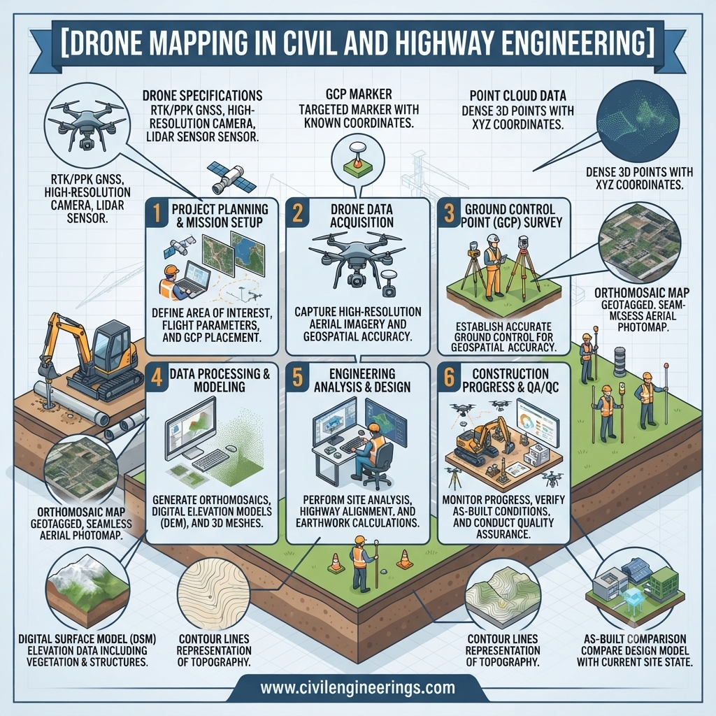
Drone mapping has changed the way civil engineers, surveyors, contractors, and infrastructure teams collect information about the ground. Instead of relying entirely on conventional total stations and lengthy field surveys, engineers can now capture hundreds or thousands of aerial images and convert them into detailed maps, orthomosaics, point clouds, digital elevation models, and 3D terrain surfaces.
The real value of Drone Mapping is not simply the ability to fly a camera over a project. Its strength comes from combining aerial photography, GNSS positioning, photogrammetry, ground control, and specialized processing software to create measurable geospatial information. This makes drone surveys particularly useful for road corridors, earthwork projects, stockpiles, construction monitoring, quarries, bridges, drainage systems, and difficult terrain.
For civil engineering professionals, the technology can reduce field exposure, improve project visibility, and provide frequent updates on changing site conditions. However, a drone does not automatically produce survey-grade information. Flight planning, image overlap, ground control, camera quality, terrain, processing methods, and independent accuracy checks all influence the final result.
This guide explains how drone mapping works, its equipment, workflow, applications, accuracy considerations, limitations, and best practices for engineering projects.
What Is Drone Mapping?
Drone mapping is the process of using an unmanned aerial vehicle (UAV), camera or other sensor, positioning technology, and mapping software to collect aerial data and convert it into useful two-dimensional or three-dimensional geospatial products.
A typical drone mapping system may combine:
- UAV or drone platform
- RGB, multispectral, thermal, or LiDAR sensor
- GNSS receiver
- Inertial Measurement Unit (IMU)
- Ground Control Points (GCPs)
- Photogrammetry software
- Surveying and CAD/GIS software
During a mapping mission, the drone follows a planned flight path and captures overlapping photographs. Photogrammetry software identifies common features between photographs and uses these tie points to reconstruct the terrain in three dimensions.
The final outputs can include an orthomosaic, digital surface model, digital terrain model, point cloud, contour map, 3D mesh, and volumetric calculations.
The Institution of Civil Engineers identifies topographic mapping, earthwork volumes, infrastructure monitoring, asset surveys, and construction progress mapping among the practical applications of UAS technology. (Institution of Civil Engineers (ICE))


How Drone Mapping Works
Drone mapping follows a systematic chain from flight planning to final engineering deliverables.
1. Define the Survey Requirement
The first step is determining exactly what the survey must achieve.
For example, a contractor may require:
- Existing ground levels
- Cut-and-fill quantities
- Stockpile volumes
- Construction progress
- Road corridor mapping
- Drainage mapping
- Slope monitoring
- As-built documentation
The required accuracy should be established before selecting the drone, sensor, flight altitude, and control strategy.
2. Plan the Flight
Flight planning determines where, how high, and how the drone will fly.
Important parameters include:
- Ground sampling distance (GSD)
- Flight altitude
- Forward overlap
- Side overlap
- Flight speed
- Camera angle
- Survey boundary
- Wind and weather conditions
- Terrain variation
A simple mapping mission normally uses a grid pattern. Linear infrastructure such as roads, pipelines, canals, and railways may require corridor-based flight planning.
3. Establish Ground Control
Ground Control Points are identifiable points on the ground whose coordinates are measured using reliable surveying equipment.
GCPs provide a reference between the aerial photographs and the actual coordinate system.
Good GCP distribution is important. Points should generally be spread throughout the project rather than concentrated in one corner.
USGS guidance emphasizes that GCP accuracy, distribution, tie points, camera calibration, and independent check points directly influence the geometric quality of UAS-derived products. (USGS Publications)
4. Capture Aerial Images
The drone automatically follows the planned route while its camera captures overlapping images.
The overlap allows photogrammetry software to identify common features in multiple photographs.
For ordinary mapping missions, high forward and side overlap is commonly used. Exact overlap values should be selected according to the sensor, terrain, software, altitude, and required accuracy rather than applying one universal number.
5. Process the Images
Specialized software performs several computational steps:
- Image alignment
- Tie-point generation
- Camera calibration
- Sparse point-cloud generation
- Dense point-cloud generation
- Georeferencing
- Surface reconstruction
- Orthomosaic generation
- Digital elevation model creation
The resulting data can then be imported into CAD, GIS, BIM, or quantity-estimation workflows.
6. Perform Quality Control
The final model should not be accepted simply because it looks visually impressive.
Survey teams should inspect:
- Check-point residuals
- Horizontal accuracy
- Vertical accuracy
- Image quality
- Gaps in coverage
- Distortions
- Vegetation effects
- Coordinate reference system
- Surface anomalies
- Point-cloud density
Independent check points are particularly valuable because they provide a separate measure of positional accuracy.
Major Drone Mapping Deliverables
Drone mapping can produce several different engineering products.
Orthomosaic Map
An orthomosaic is a geometrically corrected aerial image assembled from multiple photographs.
Unlike an ordinary aerial photograph, an orthomosaic is designed to have a consistent map relationship with the ground.
It can be used for:
- Site plans
- Road alignment documentation
- Construction monitoring
- Asset mapping
- Land-use interpretation
- Drainage investigation
- Progress records
Point Cloud
A point cloud is a large collection of three-dimensional points representing surfaces captured by the drone.
Each point can contain:
- X coordinate
- Y coordinate
- Z elevation
- Color information
- Intensity or other sensor attributes
Point clouds can support terrain modelling, 3D visualization, volume calculations, and surface analysis.
Digital Surface Model
A Digital Surface Model (DSM) represents the elevation of visible surfaces, including buildings, vegetation, equipment, and other objects.
This makes DSMs useful for understanding the complete surface environment.
Digital Terrain Model
A Digital Terrain Model (DTM) attempts to represent the bare-earth terrain.
Vegetation and structures must therefore be removed or classified where necessary.
For highway earthwork, drainage design, and terrain analysis, a properly classified terrain model is usually more useful than an unfiltered surface model.
Contour Maps
Contours can be generated from elevation data at selected intervals.
For example, a project may require 0.5 m, 1 m, or 2 m contour intervals depending on terrain and survey requirements.
3D Mesh
A textured 3D mesh creates a visually realistic representation of the surveyed environment.
It can be useful for:
- Construction visualization
- Structural inspection
- Heritage documentation
- Site communication
- Existing-condition records
Volume Calculations
Drone-derived surfaces can be compared with design or previous survey surfaces to calculate quantities.
A simplified earthwork relationship is:
Net Earthwork = Cut Volume − Fill Volume
More detailed quantity calculations are normally performed by comparing two digital surfaces.
AASHTO’s Innovation Initiative identifies digital stockpile management as an application where unmanned aerial systems and other digital technologies can support more efficient and consistent quantity measurement. (AII Transportation)


Drone Mapping Applications in Civil Engineering
The technology has applications throughout the project life cycle.
Topographic Surveying
Drone mapping can rapidly collect terrain information over large or difficult-to-access areas.
It is especially useful for:
- Hilly terrain
- Large development sites
- Quarries
- Borrow areas
- Construction corridors
- Open earthwork areas
Traditional surveying remains important, but drones can complement conventional observations by increasing the amount of spatial information collected.
Road and Highway Projects
Road construction is particularly suitable for drone-based surveying because highways cover long corridors and frequently changing work zones.
Applications include:
- Existing-ground surveys
- Road corridor mapping
- Alignment documentation
- Earthwork measurement
- Embankment monitoring
- Cut-slope mapping
- Drainage inspection
- Construction progress
- As-built documentation
Drone mapping can also provide frequent visual records of road construction without requiring survey crews to physically walk through every part of an active work area.
Earthwork and Cut-and-Fill Analysis
Earthwork quantities can change rapidly during construction.
A baseline drone survey can establish the initial surface. Subsequent flights can then generate updated surfaces.
The difference between surfaces allows engineers to investigate:
- Excavation quantities
- Embankment quantities
- Stockpile changes
- Borrow material consumption
- Waste material
- Progress against design
A 2026 ICE case study describes weekly drone surveys being used during earthworks to monitor rapidly changing site conditions and support cut-and-fill analysis. (Institution of Civil Engineers (ICE))
Stockpile Measurement
Aggregates, soil, sand, crushed stone, and other materials are often stored in large stockpiles.
Walking measurements can become difficult when stockpiles are large or irregular.
Drone mapping can generate a three-dimensional surface from which volume can be calculated against a defined base surface.
However, engineers should carefully define the stockpile base. An inaccurate base can create a significant quantity error even when the aerial model itself is excellent.
Construction Progress Monitoring
Repeated drone surveys provide a visual and measurable history of construction.
A project team can compare:
- Planned versus actual progress
- Existing versus completed work
- Design surfaces versus constructed surfaces
- Previous versus current stockpile quantities
This information can support meetings, payment documentation, planning, claims management, and project reporting.
Bridge and Infrastructure Inspection
Drones can access areas that may be difficult or hazardous for personnel.
They can capture high-resolution images of:
- Bridges
- Culverts
- Towers
- Retaining walls
- Slopes
- Roofs
- Large structures
ICE has highlighted drone use for infrastructure condition surveys because it can reduce the need for personnel to work at height or operate directly beside traffic. (Institution of Civil Engineers (ICE))
Drone imagery should not automatically replace close physical inspection where engineering standards require tactile examination, material testing, or detailed access.
Slope and Embankment Monitoring
Repeated surveys can help engineers identify changes in:
- Slope geometry
- Erosion
- Rockfall areas
- Embankment deformation
- Landslide activity
- Drainage paths
For high-risk slopes, drone data can be combined with GNSS monitoring, total stations, LiDAR, geological investigation, and other instrumentation.
Drainage and Flood Studies
Drone mapping can help visualize:
- Drainage channels
- Culvert approaches
- Roadside ditches
- Floodplain features
- Erosion
- Ponding areas
- Watercourse geometry
The elevation model can assist preliminary hydraulic and drainage analysis, although survey control and hydraulic modelling requirements must be considered before using the data for detailed design.


Drone Mapping Accuracy
Accuracy is one of the most misunderstood aspects of drone surveying.
A photograph with a very small pixel size does not automatically mean that the final survey has the same positional accuracy.
Ground Sampling Distance
Ground Sampling Distance, or GSD, describes the approximate ground dimension represented by one image pixel.
A lower GSD generally provides more image detail.
However:
Small GSD ≠ Automatically High Survey Accuracy
Accuracy also depends on:
- GCP quality
- GNSS positioning
- Camera calibration
- Image overlap
- Terrain
- Flight planning
- Processing parameters
- Lighting
- Image sharpness
- Check-point verification
USGS guidance specifically warns against assuming that low GSD alone guarantees high positional accuracy. (USGS Publications)
RTK and PPK Drone Mapping
Modern drones may use RTK or PPK positioning.
RTK — Real-Time Kinematic
RTK provides positioning corrections during flight.
PPK — Post-Processed Kinematic
PPK applies positioning corrections during post-processing.
These technologies can reduce dependence on numerous GCPs in some workflows, but they do not eliminate the need for appropriate survey control and independent validation.
For engineering projects, the correct approach is to establish the accuracy requirement first and then select the appropriate combination of RTK/PPK, GCPs, checkpoints, and conventional surveying.
Ground Control Points and Check Points
GCPs help constrain the model during processing.
Check points are used independently to evaluate the final model.
This distinction is important.
If every point used to assess accuracy also helped create the model, the reported accuracy may not represent independent validation.
USGS recommends well-distributed control and check points and emphasizes that the accuracy of the final data cannot exceed the quality of the reference information used to establish it. (USGS Publications)
Drone Mapping Equipment
A professional mapping setup normally includes more than the aircraft itself.
Drone Platform
Common platforms include:
- Multirotor drones
- Fixed-wing UAVs
- VTOL systems
Multirotors offer excellent maneuverability and are convenient for relatively compact sites and inspection work.
Fixed-wing systems are generally advantageous for covering larger areas efficiently.
ICE notes that multirotors are flexible and can carry different payloads, while fixed-wing systems are particularly suited to mapping applications. (Institution of Civil Engineers (ICE))
RGB Camera
RGB cameras are suitable for most conventional photogrammetric mapping.
They are commonly used for:
- Orthomosaics
- Topographic mapping
- Construction monitoring
- Stockpiles
- 3D models
LiDAR Sensor
Drone LiDAR can be valuable where vegetation or complex surfaces make conventional photogrammetry difficult.
Potential applications include:
- Forested corridors
- Railway embankments
- River corridors
- Slopes
- Dense vegetation
- Infrastructure mapping
ICE has highlighted UAV LiDAR applications for roads, railways, rivers, canals, embankments, cuttings, rock faces, and vegetated development sites. (Institution of Civil Engineers (ICE))
GNSS and Survey Equipment
Survey-grade GNSS receivers and total stations remain valuable for establishing:
- Control points
- Benchmarks
- Check points
- Reference coordinates
Drone mapping works best when aerial and conventional surveying methods complement one another rather than being treated as competing technologies.
Drone Mapping Workflow for a Road Project
Consider a proposed 10-kilometre highway section.
Step 1: Establish Survey Control
Surveyors establish project benchmarks and control points using appropriate GNSS or conventional survey methods.
Step 2: Define the Corridor
The survey boundary should include the required right-of-way, side slopes, drainage areas, intersections, and other relevant features.
Step 3: Plan Flights
The flight plan should account for corridor width, terrain, GSD, image overlap, airspace restrictions, and expected site conditions.
Step 4: Capture Images
The drone flies the planned routes and records high-overlap imagery.
Additional cross-flight or oblique imagery may be useful for complex terrain and structures.
Step 5: Process Data
Photogrammetry software creates:
- Point cloud
- Orthomosaic
- DSM
- DTM
- Contours
- 3D model
Step 6: Validate the Survey
Check points are compared against the model.
If residuals exceed the project’s tolerance, the survey should be investigated before engineering decisions are made.
Step 7: Export to Engineering Software
The final data can be incorporated into:
- AutoCAD
- Civil 3D
- GIS platforms
- BIM systems
- Quantity-estimation software
- Road design systems
Advantages of Drone Mapping
Drone mapping offers several practical advantages.
Faster Data Collection
Large areas can often be photographed in a fraction of the time required for extensive ground-based data collection.
Improved Site Safety
Drones can reduce personnel exposure to traffic, unstable slopes, difficult terrain, and work-at-height situations.
Frequent Surveys
Repeated flights make it practical to monitor changing sites more frequently.
Better Visual Communication
Aerial imagery and 3D models can help engineers, contractors, clients, and government agencies understand site conditions.
Useful Quantity Information
Digital surfaces can support stockpile and earthwork calculations when properly controlled and validated.
Historical Documentation
Aerial datasets provide a valuable record of site conditions at specific dates.
Limitations and Challenges of Drone Mapping
Drone mapping is powerful, but it is not a universal replacement for surveying.
Vegetation
Dense vegetation can hide the actual ground surface from RGB photogrammetry.
Weather
Strong wind, rain, fog, poor lighting, and extreme conditions can affect flight safety and image quality.
Regulatory Restrictions
Drone operations must comply with applicable aviation regulations, permissions, operational restrictions, and site safety requirements.
Processing Requirements
Large datasets can require significant computer storage and processing capacity.
Skilled Personnel
Reliable engineering outputs require people who understand surveying, photogrammetry, coordinate systems, quality control, and civil engineering requirements.
Surface Definition
Stockpiles, water, reflective surfaces, uniform materials, and repetitive textures can create difficulties for photogrammetric reconstruction.
ICE also notes that vegetation, complex materials, stockpiles, and other site conditions can affect the accuracy and processing effort of drone-derived models. (Institution of Civil Engineers (ICE))
IRC, AASHTO and ICE Considerations
Drone mapping should be integrated into existing engineering and surveying quality systems rather than treated as a separate shortcut.
IRC Considerations
For projects following Indian Roads Congress practices, drone-derived topographic information should be coordinated with the applicable survey, highway geometric design, earthwork, drainage, and construction specifications.
The drone dataset should use a clearly documented coordinate reference system and project control framework.
AASHTO Considerations
AASHTO-related highway projects should follow the applicable agency requirements for surveying, construction measurement, materials management, quality assurance, and documentation.
Drone-derived quantities should be accepted according to the project’s contractual and agency requirements rather than solely according to software output.
ICE Considerations
ICE guidance and professional material recognize UAS as useful tools for construction and surveying while emphasizing appropriate technology selection, survey accuracy, regulation, and professional judgment. (Institution of Civil Engineers (ICE))
The key principle across professional practice is straightforward:
Use drone mapping as an engineering measurement system, not merely as aerial photography.
Best Practices for Accurate Drone Mapping
For reliable civil engineering results, follow these practices:
- Define the required accuracy before flying.
- Establish reliable survey control.
- Use appropriately distributed GCPs where required.
- Reserve independent points for quality verification.
- Maintain adequate image overlap.
- Avoid unnecessary variation in flight conditions.
- Keep camera settings consistent.
- Inspect images before leaving the site.
- Record flight parameters and survey metadata.
- Check the coordinate reference system carefully.
- Review point-cloud and surface anomalies.
- Compare results with conventional survey observations where appropriate.
- Document processing software and major processing parameters.
- Do not confuse GSD with final positional accuracy.
- Keep original imagery and processed datasets properly archived.
USGS guidance also recommends documenting calibration, acquisition procedures, control information, and quality-control processes so that datasets remain traceable and useful for later analysis. (USGS Publications)
Practical Recommendations for Students, Engineers and Contractors
For Civil Engineering Students
Learn the fundamentals before focusing on drone hardware.
Understand:
- Coordinate systems
- Surveying principles
- Photogrammetry
- GNSS
- GSD
- GCPs
- Digital terrain models
- Point clouds
- CAD and GIS
A student who understands the measurement principles behind drone mapping will be far more effective than someone who only knows how to operate the drone.
For Highway Engineers
Use drone mapping for corridor visualization, earthwork monitoring, slope assessment, drainage investigation, and construction progress.
Always integrate drone data with project benchmarks and established survey control.
For Site Engineers
Repeated drone surveys can provide an excellent visual record of progress.
Use dated orthomosaics and surface comparisons to communicate actual site conditions to project managers and consultants.
For Contractors
Drone mapping can support:
- Quantity management
- Stockpile measurement
- Progress records
- Earthwork monitoring
- Subcontractor coordination
- Site documentation
However, contractual measurement should follow the agreed project specification and measurement procedure.
For Consultants and Government Engineers
Require a documented survey methodology.
The deliverable should identify:
- Equipment
- Sensor
- Coordinate system
- GCP methodology
- Check-point methodology
- Processing software
- Accuracy results
- Survey date
- Weather conditions
- Data limitations
This makes the dataset easier to audit and reuse.
Future of Drone Mapping in Civil Engineering
Drone mapping is moving beyond simple aerial photography.
Future workflows are increasingly connecting UAV data with:
- Artificial intelligence
- Automated feature extraction
- BIM
- Digital twins
- Cloud processing
- LiDAR
- Machine learning
- Automated progress tracking
- Asset management
- Predictive maintenance
ICE has recently highlighted the combination of drones, AI, image analysis, and digital twins for infrastructure inspection and asset management. (Institution of Civil Engineers (ICE))
The long-term opportunity is therefore not simply to produce better aerial images. It is to create continuously updated digital representations of infrastructure that engineers can use throughout planning, construction, operation, and maintenance.
FAQs About Drone Mapping
What is drone mapping?
Drone mapping is the process of collecting aerial imagery or sensor data with a UAV and processing it into measurable geospatial products such as orthomosaics, point clouds, digital elevation models, contours, and 3D models.
Is drone mapping accurate enough for civil engineering?
It can be, provided the survey is properly planned, controlled, processed, and independently checked. Accuracy depends on GSD, control points, GNSS positioning, camera calibration, terrain, image quality, and processing methodology.
What is GSD in drone mapping?
Ground Sampling Distance represents the approximate ground dimension covered by one image pixel. Lower GSD generally provides greater image detail, but GSD alone does not determine survey accuracy.
Do I need Ground Control Points for drone mapping?
Not every project requires the same number or configuration of GCPs. RTK and PPK systems can reduce dependence on conventional GCP workflows, but independent check points and appropriate survey control remain important for engineering-quality validation.
Can drones calculate earthwork quantities?
Yes. Drone-derived digital surfaces can be compared with design or previous surfaces to calculate cut, fill, and stockpile volumes. The reliability of the quantity depends heavily on surface quality and correct definition of the measurement boundary or base.
Can drone mapping replace traditional surveying?
Generally, it should be viewed as a complementary technology rather than a universal replacement. Total stations, GNSS receivers, benchmarks, and conventional field observations remain important for control, validation, and tasks requiring direct measurement.
Which drone is best for mapping?
There is no single best drone for every project. The appropriate platform depends on project size, required accuracy, terrain, sensor requirements, endurance, regulatory restrictions, and deliverables.
Is LiDAR better than photogrammetry?
Neither is universally better. Photogrammetry can provide excellent visual detail and is highly effective over suitable surfaces. LiDAR can offer advantages in vegetation and complex terrain. Sensor selection should follow the project’s technical requirements.
What software is used for drone mapping?
Professional workflows may use photogrammetry platforms for image processing and then transfer outputs into CAD, GIS, BIM, or specialized surveying software. The most appropriate software depends on the required deliverables and accuracy standards.
Is drone mapping useful for highway construction?
Yes. Highway applications include topographic surveys, corridor mapping, earthwork calculations, embankment monitoring, stockpile measurement, drainage investigation, construction progress, and as-built documentation.
Conclusion
Drone Mapping has become an important tool in modern civil engineering because it combines rapid aerial data collection with photogrammetry, GNSS positioning, 3D modelling, and digital analysis. For highway projects, construction sites, earthworks, stockpiles, slopes, bridges, and infrastructure assets, it can provide information that is difficult to collect efficiently through conventional field methods alone.
The greatest benefit, however, comes from using the technology correctly. A drone flight without proper control, flight planning, processing, and quality verification may produce an attractive model but not a dependable engineering survey. Professional results require an understanding of GSD, GCPs, RTK/PPK positioning, coordinate systems, point clouds, surface models, and independent accuracy checks.
For students, Drone Mapping offers an important bridge between surveying and digital engineering. Engineers and contractors, it can improve site visibility, quantity management, safety, and construction monitoring. For consultants and infrastructure owners, repeated drone surveys can create valuable project records and support data-driven decision-making.
Used as part of a controlled engineering workflow, drone mapping is not simply a faster way to take aerial photographs. It is a practical geospatial technology capable of improving how infrastructure is surveyed, designed, constructed, monitored, and maintained.

Kamran Malik is a passionate civil engineering writer and researcher who specializes in construction, transportation, structural engineering, and infrastructure topics. Through his articles on CivilEngineerings.com, he simplifies complex engineering concepts and shares practical insights, industry trends, and educational resources for students, professionals, and engineering enthusiasts.