
Introduction
A Cross Section Survey plays a vital role in every road and highway construction project. Engineers rely on this survey to understand the existing ground profile across the proposed road alignment. The collected data helps designers calculate earthwork quantities, prepare accurate roadway cross-sections, design drainage systems, and determine the most economical road formation level.
Without a detailed cross section survey, highway engineers cannot estimate cut-and-fill volumes accurately. Design errors may increase construction costs, delay project completion, and reduce pavement performance. Therefore, transportation engineers perform this survey after completing the alignment survey and before preparing the final roadway design.
Whether the project involves a rural road, urban street, expressway, or national highway, the survey provides essential information for geometric design, slope stability, drainage planning, and construction management. This guide explains every aspect of a Cross Section Survey, including its objectives, engineering principles, equipment, field procedure, practical applications, and best practices. The article serves as a valuable resource for civil engineers, contractors, surveyors, and engineering students.
What Is a Cross Section Survey?
A Cross Section Survey is a topographic survey carried out at right angles to the center line of a proposed or existing road, railway, canal, or other linear infrastructure project. It measures the ground levels across the width of the project corridor at regular intervals.
The survey creates a series of transverse profiles that show the natural ground surface on both sides of the center line. These profiles enable engineers to compare the existing terrain with the proposed design level and calculate the amount of excavation and embankment required.
Unlike a longitudinal profile, which represents ground levels along the center line, a cross section survey captures the shape of the land from one side of the alignment to the other.
Key Features
- Conducted perpendicular to the center line.
- Records ground elevations at selected offsets.
- Identifies changes in terrain.
- Supports earthwork calculations.
- Assists in geometric road design.
- Provides data for drainage and slope design.
Objectives of a Cross Section Survey
Every engineering survey has a specific purpose. A cross section survey provides the information needed to transform field conditions into an efficient and economical road design.
Primary Objectives
Determine Existing Ground Profile
Engineers collect elevation data to understand the natural shape of the land across the alignment.
Calculate Earthwork Quantities
Survey data helps estimate the volume of soil that requires excavation or embankment.
Design Road Formation Width
The survey identifies the space available for carriageways, shoulders, medians, and side slopes.
Design Side Slopes
Ground information allows engineers to determine safe and stable cutting or filling slopes.
Plan Drainage Systems
The survey reveals natural drainage paths and low-lying areas where water may accumulate.
Improve Cost Estimation
Accurate earthwork quantities reduce budgeting errors and improve project planning.
Support Construction Activities
Contractors use cross-section drawings during grading, excavation, and embankment construction.
Why Cross Section Survey Matters in Road Engineering
Road construction requires accurate geometric information. Even minor errors in elevation measurements can significantly affect pavement performance and construction costs.
A well-executed cross section survey provides several engineering benefits.
Accurate Earthwork Estimation
Earthwork often represents one of the largest components of highway construction costs. Accurate survey data enables engineers to optimize excavation and filling operations.
Better Highway Geometry
Cross-section information supports the design of:
- Lane widths
- Road shoulders
- Side slopes
- Medians
- Drainage channels
- Embankments
Improved Drainage Design
Proper drainage protects pavement layers from water damage. Survey data helps engineers identify natural flow paths and design efficient drainage systems.
Enhanced Construction Efficiency
Reliable field measurements reduce design revisions and construction delays.
Increased Road Safety
Proper cross-sectional design improves vehicle stability, visibility, and roadside safety.
Engineering Principles Behind Cross Section Survey
Several engineering principles guide the execution and interpretation of a cross section survey.
Accuracy
Survey observations should achieve the required precision because design calculations depend entirely on field measurements.
Consistency
Survey intervals and measurement methods should remain consistent throughout the project to maintain uniform data quality.
Representative Sampling
Measurements must capture all significant changes in terrain, including depressions, embankments, drainage channels, and steep slopes.
Right-Angle Measurement
Each cross section should intersect the center line at approximately 90 degrees unless project conditions require a modified approach.
Data Verification
Survey teams should verify measurements before leaving the site to minimize costly rework.
Equipment Used for Cross Section Survey
Modern highway projects use advanced surveying equipment to improve speed and accuracy.
Traditional Survey Equipment
- Dumpy Level
- Automatic Level
- Levelling Staff
- Measuring Tape
- Ranging Rod
- Pegs
- Cross Staff
Modern Survey Equipment
- Total Station
- Digital Level
- GNSS/GPS Receiver
- Electronic Data Collector
- Drone (UAV) Survey System
- Laser Scanner
Software Used
Survey data is commonly processed using:
- AutoCAD Civil 3D
- Bentley OpenRoads
- Leica Infinity
- Trimble Business Center
- GIS software
Modern digital equipment reduces human error and increases productivity, especially on long highway corridors.
Cross Section Survey Procedure
Survey teams follow a systematic procedure to produce accurate and reliable cross sections.
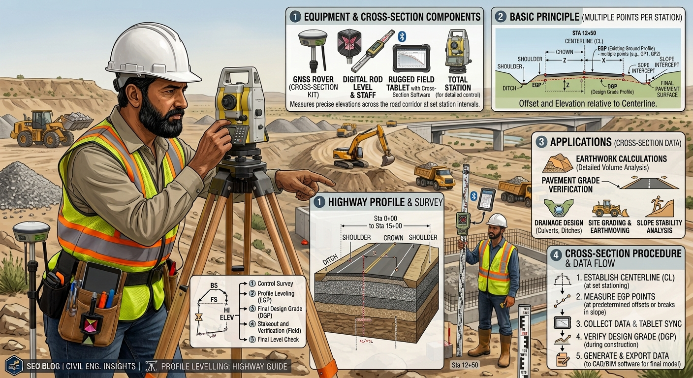
Step 1: Establish the Center Line
The survey begins by locating and marking the approved road center line using control points established during the alignment survey.
Engineers install pegs at regular chainages, such as every 20 m, 25 m, or 50 m, depending on project requirements and terrain conditions.
Step 2: Set Cross Section Intervals
Surveyors establish cross sections at predetermined intervals along the center line.
Typical spacing includes:
- 20 m in urban projects
- 25 m for moderate terrain
- 50 m on relatively uniform ground
Additional sections are taken wherever the terrain changes abruptly, such as near streams, embankments, intersections, or steep slopes.
Step 3: Measure Offsets
From each center-line station, surveyors measure horizontal offsets toward both sides of the alignment.
Offset distances depend on:
- Proposed road width
- Side slopes
- Drainage requirements
- Right-of-way limits
Measurements continue until the survey covers the full construction corridor.
Step 4: Record Ground Elevations
The survey team records elevations at every offset point using a level or total station.
Special attention is given to features such as:
- Existing roads
- Ditches
- Utility poles
- Buildings
- Trees
- Streams
- Culverts
- Fences
These observations provide valuable information during highway design.
Step 5: Prepare Cross Section Drawings
Engineers transfer field data into design software to prepare cross-sectional drawings.
Each drawing shows:
- Existing ground profile
- Proposed road profile
- Cut areas
- Fill areas
- Side slopes
- Formation width
- Drainage elements
These drawings become part of the final construction documents.
Cross Section Survey Diagram
Typical Highway Cross Section Survey
                  Existing Ground Surface
        _______________________________________

        *      *      *      *      *      *
       /                              \
------/--------------------------------\------
     L Offset     Center Line       R Offset

      ←-------- Cross Section --------→

Survey readings are taken at each offset point to
create the ground profile used for road design.
Relationship Between Longitudinal and Cross Section Surveys
Road Center Line
───────────────────────────────────────────────►

|      |      |      |      |      |
|      |      |      |      |      |
▼      ▼      ▼      ▼      ▼      ▼

Cross Section  Cross Section  Cross Section
      ⟂              ⟂               ⟂
The longitudinal survey records elevations along the alignment, while each cross section captures the terrain across the roadway corridor.
Practical Engineering Example
A transportation agency plans a 12 km two-lane highway through rolling terrain. The survey team establishes the center line and carries out cross section surveys at 25 m intervals. Additional sections are measured at bridge approaches, stream crossings, and sharp terrain changes.
The collected data reveals several deep depressions and elevated ridges along the proposed alignment. Engineers use these profiles to balance cut-and-fill operations, reducing the need to import or dispose of large quantities of soil. They also identify locations where side drains and culverts are necessary to maintain effective surface drainage.
As a result, the design team develops a more economical highway layout with lower earthwork costs, improved drainage performance, and enhanced long-term stability.
Applications of Cross Section Survey in Road Engineering
A Cross Section Survey supports nearly every stage of a highway project. Engineers use the collected data to make informed design decisions, estimate project costs, and manage construction activities. Accurate cross-sectional information improves efficiency and reduces unexpected site issues.
1. Highway Geometric Design
Engineers use cross sections to determine:
- Carriageway width
- Shoulder width
- Median width
- Embankment dimensions
- Side slope geometry
- Formation level
The survey ensures that the proposed highway fits the existing terrain while maintaining safe driving conditions.
2. Earthwork Quantity Calculation
Earthwork represents a major portion of highway construction costs.
Cross section data allows engineers to calculate:
- Cut volume
- Fill volume
- Borrow material requirements
- Spoil disposal quantities
Balanced earthwork reduces hauling distances and lowers overall project costs.
3. Pavement Design
The survey identifies existing ground conditions that influence pavement performance.
Engineers use the information to:
- Determine subgrade levels
- Establish pavement thickness
- Design pavement layers
- Improve long-term structural performance
4. Drainage System Design
Proper drainage begins with accurate ground profiles.
Cross section surveys help engineers design:
- Side drains
- Catch water drains
- Roadside ditches
- Culverts
- Median drainage systems
Effective drainage protects pavement layers from water damage and extends service life.
5. Bridge and Culvert Approaches
Approach embankments require smooth elevation transitions.
Cross-sectional data allows engineers to design:
- Bridge approaches
- Culvert inlets
- Culvert outlets
- Embankment slopes
Proper design improves driving comfort and structural stability.
6. Road Widening Projects
Engineers also perform cross section surveys before widening existing roads.
The survey identifies:
- Existing pavement width
- Shoulder conditions
- Utility locations
- Side slopes
- Drainage structures
This information simplifies rehabilitation and expansion projects.
Practical Applications in Real Projects
National Highways
Survey teams prepare cross sections throughout the proposed alignment to estimate excavation quantities and design embankments.
Urban Roads
Municipal engineers use cross section surveys to coordinate roads, footpaths, drainage channels, utilities, and street lighting.
Mountain Roads
Engineers rely on detailed cross sections to evaluate steep slopes, rock cuttings, retaining walls, and landslide risks.
Airport Runways
Cross-sectional surveys support grading, pavement design, and drainage planning for runways and taxiways.
Railway Projects
Railway engineers use transverse profiles to design embankments, cuttings, ballast thickness, and drainage facilities.
Common Challenges During Cross Section Survey
Field conditions often create challenges that affect survey accuracy and productivity.
Dense Vegetation
Trees and shrubs may block instrument sight lines.
Solution
Clear only the necessary survey corridor while protecting the surrounding environment.
Uneven Terrain
Steep slopes make it difficult to measure offsets accurately.
Solution
Use a Total Station, GNSS equipment, or drone surveys to improve accuracy.
Poor Weather Conditions
Heavy rain, fog, or strong winds reduce visibility and affect instrument performance.
Solution
Schedule surveys during favorable weather and protect equipment from moisture.
Traffic on Existing Roads
Moving vehicles create safety risks for survey teams.
Solution
Implement traffic management plans, warning signs, and high-visibility safety clothing.
Data Recording Errors
Incorrect field notes may lead to inaccurate design calculations.
Solution
Use digital data collectors and verify measurements before leaving the site.
Best Practices for Cross Section Survey
Experienced highway engineers follow proven practices to achieve reliable survey results.
- Verify survey control points before starting fieldwork.
- Calibrate instruments according to manufacturer recommendations.
- Maintain consistent cross section intervals throughout the project.
- Take additional sections at sudden terrain changes.
- Check field data daily for completeness and accuracy.
- Use digital survey equipment whenever practical.
- Maintain clear communication between surveyors and design engineers.
- Store survey data securely with proper backups.
- Review cross-section drawings before final design approval.
Following these practices improves design quality and minimizes costly revisions.
Practical Recommendations
Civil Engineers
- Review survey data carefully before beginning geometric design.
- Compare cross sections with longitudinal profiles to identify inconsistencies.
- Confirm field conditions through site visits before finalizing design drawings.
- Incorporate drainage requirements during the initial design stage.
Contractors
- Verify existing ground levels before excavation begins.
- Protect survey benchmarks throughout construction.
- Use cross-section drawings to monitor cut-and-fill operations.
- Coordinate regularly with survey teams during grading activities.
Surveyors
- Double-check instrument calibration each day.
- Maintain accurate field notes and digital backups.
- Establish clear communication with the design office.
- Follow standard surveying procedures throughout the project.
Engineering Students
- Practice preparing cross-sectional drawings manually before using software.
- Learn to interpret field books and survey records.
- Understand the relationship between cross sections and earthwork calculations.
- Visit highway construction projects to observe field surveying techniques.
Common Mistakes to Avoid
Several common mistakes reduce survey quality and increase project risks.
- Using incorrect benchmark elevations.
- Taking cross sections at irregular intervals.
- Ignoring sudden terrain changes.
- Recording incomplete field observations.
- Failing to identify existing utilities.
- Skipping data verification.
- Neglecting drainage features during the survey.
- Using poorly calibrated instruments.
- Preparing drawings without checking field measurements.
- Overlooking safety procedures during fieldwork.
Avoiding these mistakes improves both survey accuracy and project efficiency.
General Discussion of IRC, AASHTO, and ICE Practices
Leading highway engineering organizations emphasize the importance of accurate surveying as the foundation of successful infrastructure projects.
General engineering guidance commonly recommends:
- Establishing reliable horizontal and vertical control before beginning surveys.
- Performing detailed topographic and cross section surveys for all proposed alignments.
- Maintaining consistent survey intervals while increasing survey frequency in areas with significant terrain variation.
- Using suitable survey equipment based on project complexity and required accuracy.
- Integrating survey information with geometric design, drainage planning, and earthwork estimation.
- Verifying field measurements through quality assurance procedures before preparing construction drawings.
Following these widely accepted engineering principles helps improve safety, construction efficiency, and long-term pavement performance.
Frequently Asked Questions (FAQs)
1. What is a Cross Section Survey?
A Cross Section Survey measures ground elevations at right angles to a road or highway center line to create transverse profiles for design and earthwork calculations.
2. Why is a Cross Section Survey important in road construction?
It provides the data needed for roadway design, earthwork estimation, drainage planning, pavement design, and construction planning.
3. How often should cross sections be taken?
Survey intervals vary with project requirements. Engineers commonly use 20 m, 25 m, or 50 m spacing and add extra sections where terrain changes significantly.
4. Which equipment is commonly used for a Cross Section Survey?
Common equipment includes Total Stations, GNSS receivers, Automatic Levels, Digital Levels, levelling staffs, drones, and electronic data collectors.
5. What is the difference between a longitudinal survey and a cross section survey?
A longitudinal survey records elevations along the road center line, while a cross section survey measures ground levels across the alignment at right angles.
6. How does a Cross Section Survey help estimate earthwork?
Engineers compare existing ground levels with the proposed road profile to calculate excavation and embankment volumes accurately.
7. Can drone technology improve Cross Section Surveys?
Yes. Drones quickly capture topographic data over large areas and improve efficiency, especially on difficult terrain, while supporting detailed digital terrain models.
8. What factors influence cross section spacing?
Terrain variability, project type, design requirements, construction complexity, and applicable engineering standards determine appropriate survey intervals.
9. Who uses Cross Section Survey data?
Civil engineers, highway designers, surveyors, contractors, quantity surveyors, and project managers all rely on cross section survey information.
10. Which stage of a highway project requires a Cross Section Survey?
Survey teams usually conduct it after alignment surveys and before detailed geometric design and earthwork planning.
Conclusion
A Cross Section Survey forms one of the most important stages in highway and road engineering because it provides the detailed ground information required for safe, economical, and efficient infrastructure design. Engineers use the survey data to calculate earthwork quantities, design pavement layers, establish roadway geometry, and develop reliable drainage systems. Accurate cross sections also improve cost estimation, reduce construction risks, and support effective project management throughout the construction lifecycle. Modern technologies such as Total Stations, GNSS receivers, drones, and digital terrain modeling have significantly enhanced survey accuracy and productivity, yet careful field procedures and engineering judgment remain essential. Engineers, contractors, surveyors, and students who understand the principles and applications of a Cross Section Survey can make better technical decisions, improve construction quality, and contribute to the successful delivery of durable transportation infrastructure that meets both present and future traffic demands.
