
Introduction
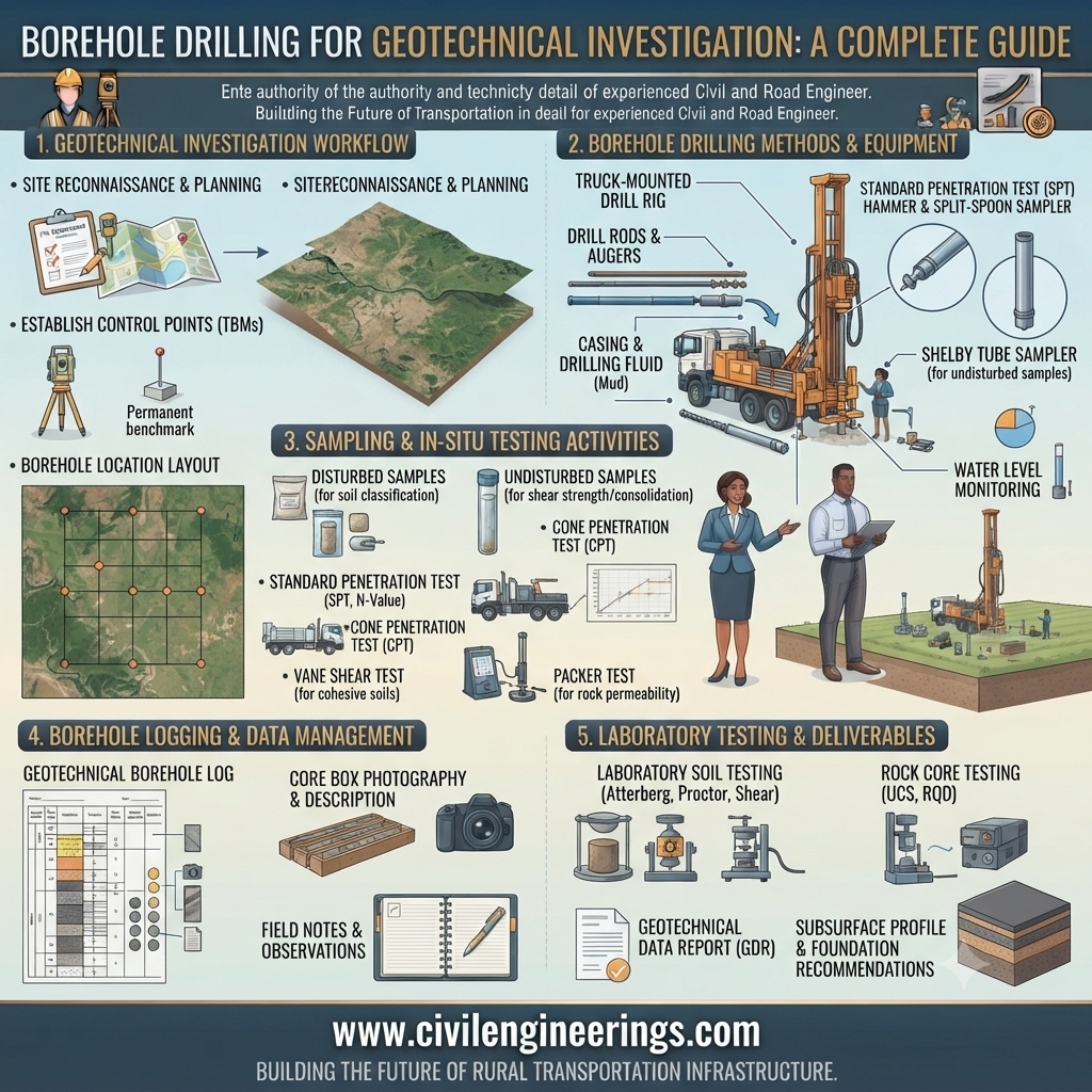
Every successful construction project begins beneath the surface. Whether you’re designing a highway, bridge, high-rise building, or retaining wall, understanding subsurface soil and rock conditions is essential for safe and economical engineering decisions. Borehole Drilling for Geotechnical Investigation is one of the most reliable methods for collecting underground information that influences foundation design, slope stability, pavement performance, groundwater control, and earthwork planning.
This comprehensive guide explains the complete borehole drilling process, equipment, drilling methods, sampling techniques, quality control procedures, engineering calculations, applicable standards, and best practices. Whether you are a civil engineering student, highway engineer, consultant, contractor, or researcher, this article provides practical insights based on real-world engineering experience.
What is Borehole Drilling for Geotechnical Investigation?
Borehole Drilling for Geotechnical Investigation is the process of drilling vertical or inclined holes into the ground to determine the physical and engineering properties of soil and rock beneath a proposed construction site.
The investigation helps engineers collect:
- Soil samples
- Rock cores
- Groundwater information
- In-situ test results
- Soil stratification data
- Engineering properties for design
These findings form the basis for safe foundation and pavement design.
Why Borehole Drilling is Important
Without proper subsurface investigation, engineers risk:
- Foundation failure
- Pavement settlement
- Landslides
- Slope instability
- Excessive construction costs
- Unexpected groundwater problems
A properly executed borehole investigation minimizes uncertainty and improves project safety.
Objectives of Borehole Drilling for Geotechnical Investigation
Major objectives include:
- Determine soil profile
- Identify rock depth
- Locate groundwater table
- Obtain representative samples
- Perform in-situ testing
- Evaluate bearing capacity
- Assess settlement characteristics
- Support pavement design
- Analyze slope stability
- Recommend foundation type
Planning a Borehole Investigation
Proper planning improves investigation quality and reduces project costs.
Site Reconnaissance
Before drilling, engineers should inspect:
- Existing roads
- Drainage
- Topography
- Geological formations
- Nearby structures
- Utility lines
Borehole Location Selection
Locations depend on:
- Structure size
- Foundation type
- Geological variation
- Highway alignment
- Bridge abutments
- Embankments
- Retaining walls
Borehole Depth Determination
Typical recommendations:
| Structure | Approximate Borehole Depth |
|---|---|
| Residential Building | 10–20 m |
| Highway Pavement | 3–8 m |
| Bridge Foundation | 25–60 m |
| High-Rise Building | 30–80 m |
| Dam | Project-specific |
Depth depends on competent bearing strata and project requirements.
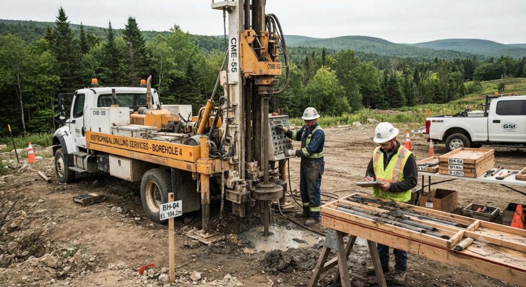
Borehole Drilling Methods
1. Auger Drilling
Suitable for:
- Soft soils
- Clay
- Silt
- Sand above groundwater
Advantages:
- Fast
- Economical
- Simple equipment
Limitations:
- Limited depth
- Unsuitable for hard rock
2. Rotary Drilling
Uses rotating drill bits with drilling fluid.
Suitable for:
- Deep boreholes
- Mixed soils
- Rock formations
Advantages:
- High productivity
- Greater depth
- Continuous drilling
3. Percussion Drilling
A heavy chisel repeatedly breaks the soil or rock.
Commonly used in:
- Hard formations
- Boulder deposits
4. Wash Boring
Water is pumped through drill rods to loosen soil.
Common for:
- Sandy soils
- Silty deposits
Often combined with Standard Penetration Tests (SPT).
5. Rotary Core Drilling
Used for obtaining continuous rock cores.
Provides:
- Rock Quality Designation (RQD)
- Rock strength evaluation
- Geological logging
Borehole Equipment
Typical drilling equipment includes:
- Drilling rig
- Drill rods
- Drill bits
- Core barrels
- Split spoon sampler
- Shelby tube
- Water pump
- Mud pump
- Casing pipes
- Winch
- Tripod
- Measuring tape
- Borehole camera (where required)
Simple Borehole Drilling Process
Ground Surface
====================

      │
      │
      │
   Borehole
      │
      │
      │
-----------------------
Clay
-----------------------
Sand
-----------------------
Gravel
-----------------------
Rock
#######################
Soil and Rock Sampling
Proper sampling determines laboratory test accuracy.
Disturbed Samples
Used for:
- Grain size analysis
- Atterberg limits
- Compaction tests
Collected using:
- Split spoon sampler
- Auger cuttings
Undisturbed Samples
Used for:
- Consolidation
- Shear strength
- Permeability
- Triaxial tests
Collected using:
- Shelby tube
- Piston sampler
Rock Core Sampling
Provides:
- Rock type
- Weathering
- Fractures
- RQD
In-Situ Testing
Several field tests accompany Borehole Drilling for Geotechnical Investigation.
Standard Penetration Test (SPT)
Measures soil resistance.
Output:
- N-value
Widely used for:
- Foundation design
- Liquefaction analysis
- Settlement estimation
Cone Penetration Test (CPT)
Measures:
- Cone resistance
- Sleeve friction
Suitable for:
- Soft clay
- Sand
Pressuremeter Test
Provides:
- Soil modulus
- Deformation characteristics
Vane Shear Test
Used in:
- Soft clays
Determines undrained shear strength.
Borehole Logging
Every borehole should be logged carefully.
Typical log information:
- Borehole ID
- Coordinates
- Elevation
- Soil layers
- Rock depth
- Groundwater level
- Sample intervals
- SPT values
- Recovery percentage
- RQD
Borehole Log Diagram
Depth (m)

0
│ Topsoil
│
2
│ Clay
│
5
│ Sand
│
8
│ Gravel
│
12
│ Weathered Rock
│
18
│ Fresh Rock
Groundwater Observation
Groundwater affects:
- Excavation stability
- Foundation design
- Dewatering
- Pavement drainage
Observation methods include:
- Standpipe piezometers
- Observation wells
- Water level indicators
Engineering Calculations
1. Bearing Pressure
[
q = \frac{P}{A}
]
Where:
- q = Bearing pressure (kPa)
- P = Applied load (kN)
- A = Foundation area (m²)
Example
Foundation load = 900 kN
Foundation area = 4 m²
[
q=\frac{900}{4}=225\text{ kPa}
]
Bearing pressure = 225 kPa
2. Rock Quality Designation (RQD)
[
RQD=\frac{\text{Length of core pieces >100 mm}}{\text{Total core run}} \times100
]
Example
Core pieces >100 mm = 85 cm
Core run =100 cm
RQD
=85%
Excellent rock quality.
3. Unit Weight
[
\gamma=\frac{W}{V}
]
Where
γ = Unit weight
W = Weight
V = Volume
Quality Control Testing
Although borehole investigations focus on subsurface characterization, laboratory and field quality control tests complement the findings.
CBR Test
Determines subgrade strength for pavement design.
Standard Proctor Test
Establishes optimum moisture content and maximum dry density.
Modified Proctor Test
Used for heavily loaded pavements and embankments.
Density Test
Confirms field compaction meets design requirements.
Plate Load Test
Evaluates bearing capacity and settlement characteristics.
Core Test
Assesses concrete quality in completed structural elements.
Slump Test
Checks concrete workability before placement.
Marshall Stability Test
Used for asphalt mix design in highway construction.
Best Practices for
Engineers
- Conduct sufficient boreholes across the site.
- Verify geological conditions with field observations.
- Correlate laboratory and field test results.
- Document groundwater conditions carefully.
- Maintain complete borehole logs.
Contractors
- Calibrate drilling equipment regularly.
- Protect boreholes from collapse.
- Label all samples immediately.
- Avoid sample contamination.
- Follow approved drilling procedures.
Students
- Learn soil classification systems.
- Practice borehole logging techniques.
- Understand SPT interpretation.
- Study sampling methods thoroughly.
- Relate laboratory data to field observations.
Common Mistakes
- Drilling too few boreholes.
- Selecting inadequate investigation depth.
- Poor sample handling.
- Ignoring seasonal groundwater fluctuations.
- Incomplete borehole logs.
- Misinterpreting SPT values.
- Failing to calibrate equipment.
- Using disturbed samples for advanced strength tests.
- Overlooking geological discontinuities.
- Poor coordination between field and laboratory teams.
Engineering Standards (General Overview)
Professional geotechnical investigations commonly follow guidance from internationally recognized organizations, including:
- IRC (Indian Roads Congress): Road and highway geotechnical investigation practices.
- AASHTO: Transportation infrastructure and pavement-related geotechnical guidance.
- ASTM: Standardized methods for soil sampling, drilling, laboratory testing, and field investigations.
- ICE: Good engineering practice for geotechnical design and construction.
- ISO: Quality management and testing frameworks applicable to engineering investigations.
- FHWA: Best practices for highway geotechnical engineering, site characterization, and foundation investigations.
Engineers should always apply the latest project-specific national codes, client specifications, and regulatory requirements.
Frequently Asked Questions
1. Why is Borehole Drilling for Geotechnical Investigation necessary before construction?
Borehole drilling reveals underground soil and rock conditions that cannot be observed from the surface. It helps engineers determine bearing capacity, groundwater levels, settlement potential, and suitable foundation systems. Investing in a proper investigation reduces construction risks, prevents costly redesigns, and improves long-term structural performance.
2. How many boreholes are usually required for a project?
The required number depends on project size, soil variability, foundation type, and applicable standards. Small residential developments may need only a few boreholes, while highways, bridges, and industrial facilities often require investigations at regular intervals and at critical structural locations. A qualified geotechnical engineer should determine the appropriate investigation program.
3. What is the difference between disturbed and undisturbed soil samples?
Disturbed samples are suitable for classification tests such as grain size distribution and Atterberg limits because their natural structure is altered during sampling. Undisturbed samples preserve the in-situ soil fabric and moisture conditions, making them essential for consolidation, permeability, and shear strength testing used in foundation and settlement analyses.
4. What is the Standard Penetration Test (SPT), and why is it important?
The Standard Penetration Test measures soil resistance by recording the number of hammer blows required to drive a split-spoon sampler into the ground. The resulting N-value provides an indication of soil density or consistency and is widely used to estimate bearing capacity, settlement, and liquefaction potential in geotechnical engineering.
5. How deep should a geotechnical borehole be?
The investigation depth depends on the type of structure, expected loading, local geology, and engineering objectives. Boreholes should extend beyond the influence zone of the proposed foundation or until competent strata are encountered. Large structures such as bridges and high-rise buildings generally require significantly deeper investigations than pavements or low-rise buildings.
6. What role does groundwater play in borehole investigations?
Groundwater conditions influence excavation stability, soil strength, settlement behavior, and construction methods. Monitoring groundwater levels during and after drilling enables engineers to design appropriate drainage, dewatering, waterproofing, and foundation systems while reducing the risk of uplift or seepage-related failures.
7. Which drilling method is best for geotechnical investigations?
No single drilling method suits every project. Auger drilling is efficient for shallow cohesive soils, rotary drilling is preferred for deeper and mixed formations, while rotary core drilling is the standard choice for obtaining high-quality rock cores. The selected method should match the site’s geology and project requirements.
Conclusion
Borehole Drilling for Geotechnical Investigation is the cornerstone of reliable geotechnical engineering and a critical step in the success of infrastructure projects. By accurately identifying subsurface conditions, collecting representative samples, performing in-situ tests, and documenting groundwater behavior, engineers can design safer foundations, more durable pavements, and cost-effective earthworks. Combining sound investigation planning with quality control, proper sampling techniques, and internationally recognized engineering practices significantly reduces construction risks and unexpected site challenges. Whether you are a student building technical knowledge or a practicing engineer managing complex projects, mastering borehole investigation principles will improve decision-making and project outcomes. Apply these best practices on every site and invest in thorough geotechnical investigations to ensure long-term safety, performance, and value.

Kamran Malik is a passionate civil engineering writer and researcher who specializes in construction, transportation, structural engineering, and infrastructure topics. Through his articles on CivilEngineerings.com, he simplifies complex engineering concepts and shares practical insights, industry trends, and educational resources for students, professionals, and engineering enthusiasts.