
Introduction
Surveying is the foundation of every successful civil engineering and construction project. Before engineers design roads, highways, bridges, buildings, or irrigation systems, they must first collect accurate measurements of the land. Among the various surveying methods, Chain Survey remains one of the simplest, most economical, and widely taught techniques for measuring small areas with high accuracy.
Although modern projects increasingly rely on total stations, GNSS, and drones, chain surveying continues to play an important role in engineering education and fieldwork. It is particularly useful for small construction sites, rural roads, property boundaries, agricultural land, and preliminary engineering investigations where the terrain is relatively flat and free from significant obstacles.
Understanding Chain Survey helps engineers, contractors, surveyors, and students build a strong foundation in linear measurement, field observations, and map preparation. The principles learned through chain surveying also support more advanced surveying methods used in contemporary infrastructure projects.
This guide explains the concept, principles, equipment, procedures, engineering applications, and practical examples of chain surveying while following recognized surveying practices and modern engineering standards.
What is Chain Survey?
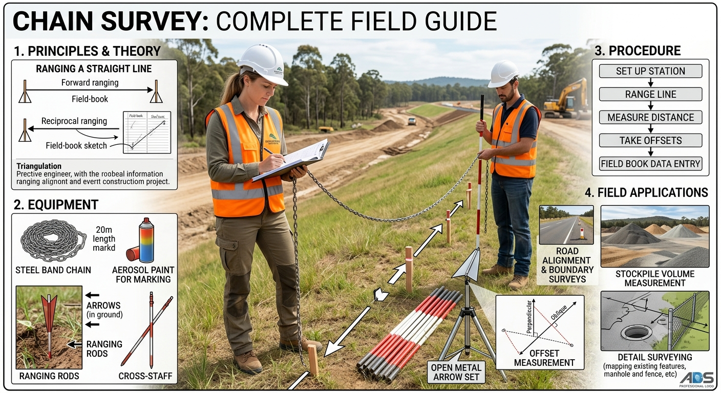
Surveyors use Chain Survey, one of the oldest and most fundamental methods of land surveying, to take linear measurements using a chain, tape, or similar measuring instrument. It is based on the principle of dividing the survey area into a network of well-conditioned triangles. Once surveyors measure the survey lines, they determine the positions of natural and human features by taking perpendicular or oblique offsets.
Unlike advanced surveying techniques that require sophisticated electronic equipment, chain surveying uses simple tools and careful field procedures. It best suits users in small, open, and relatively level areas where they do not require high precision angular measurements.
Definition
Surveyors use the Chain Survey method to determine the relative positions of points by measuring distances on the ground and plotting them to scale using a framework of triangles.
Importance of Chain Survey in Civil Engineering
Despite technological advancements, chain surveying remains an essential topic in civil engineering because it introduces the fundamental concepts of measurement, fieldwork, and mapping.
Why Chain Survey Is Important
- Provides the basis for understanding land surveying.
- Helps prepare preliminary site plans.
- Requires minimal equipment and low operational cost.
- Suitable for educational and training purposes.
- Produces reliable results for small engineering projects.
- Supports property boundary and agricultural surveys.
- Serves as a preliminary survey before detailed investigations.
Engineering Applications
Chain surveying commonly use for:
- Residential building layouts
- Small road projects
- Farm boundary measurements
- Park development
- School campuses
- Canal alignments
- Playground planning
- Utility line surveys
Principles of Chain Survey
The accuracy of a chain survey depends on following several important engineering principles. Understanding these principles helps minimize measurement errors and ensures reliable survey results.
1. Principle of Triangulation
Researchers divide the entire survey area into a series of triangles because a triangle is the simplest geometric figure that can be fixed accurately by measuring its sides.
A well-conditioned triangle should have angles that are neither too small nor too large. Ideally, no angle should be less than 30° or greater than 120°.
Diagram: Principle of Triangulation
            A
           / \
          /   \
         /     \
        /       \
       B---------C
Each side of the triangle is measured carefully, creating a stable framework for plotting the survey.
2. Accurate Linear Measurement
All survey lines must be measured accurately using standardized equipment. Any error in distance measurement directly affects the final map.
Surveyors should:
- Keep the chain straight.
- Apply proper tension.
- Measure on level ground whenever possible.
- Correct measurements on sloping terrain.
3. Well-Conditioned Survey Lines
The main survey lines should provide.
- Clear visibility
- Easy access
- Minimum obstacles
- Maximum accuracy
Long unnecessary lines should be avoided because cumulative measurement errors are increased by them.
4. Check Lines
They measure check lines (also called proof lines) to verify the accuracy of the triangular framework.
If the measured check line differs significantly from the plotted length, surveyors know that an error has occurred.
Diagram: Check Line
        A
       / \
      /   \
     /  D  \
    /       \
   B---------C

BD = Check Line
Equipment Used in Chain Survey
Although chain surveying uses relatively simple instruments, each tool has a specific purpose that contributes to measurement accuracy.
1. Metric Chain
The metric chain is the primary measuring instrument used in chain surveying.
Common lengths include:
- 20 m
- 30 m
Each chain consists of steel links connected by rings with brass handles at both ends.
Uses
- Measuring survey lines
- Measuring offsets
- Establishing baselines
2. Steel Tape
Steel tapes provide greater precision than chains and are often used for checking important measurements.
Common lengths include:
- 10 m
- 20 m
- 30 m
- 50 m
3. Arrows (Chain Pins)
Arrows are thin steel rods placed at the end of each chain length to mark measurement points.
Generally, a set contains 10 arrows, making it easier to count completed chain lengths.
4. Ranging Rods
Ranging rods help establish straight survey lines.
They are usually:
- 2–3 m long
- Painted in alternating red and white (or black and white) bands
- Fitted with a pointed steel shoe for easy insertion into the ground
5. Pegs
Wooden or steel pegs permanently mark important survey stations and reference points.
6. Offset Rod
Offset rods are used to measure short perpendicular distances from the main survey line to locate nearby features.
Examples include:
- Trees
- Buildings
- Fences
- Utility poles
7. Cross Staff
A cross staff is used to set out right angles when taking offsets.
It is simple, lightweight, and widely used for ordinary chain surveys.
8. Optical Square
An optical square performs the same function as a cross staff but provides higher accuracy when setting perpendicular offsets.
9. Plumb Bob
A plumb bob transfers points vertically and is particularly useful when measuring on uneven terrain.
10. Field Book
The field book is where survey observations, chainages, offsets, sketches, and notes are recorded.
A well-maintained field book serves as the official record of the survey.
Types of Chains Used in Surveying
Several types of chains have been used throughout the history of surveying. The choice depends on regional practices and project requirements.
Metric Chain
The most commonly used chain in modern surveying, graduated in metres and centimetres.
Engineer’s Chain
Traditionally used in engineering works and measured in feet.
Gunter’s Chain
A historical chain consisting of 66 feet divided into 100 links. It was widely used in land measurement and cadastral surveys.
Revenue Chain
Typically 33 feet long and historically used for revenue and land record surveys in some regions.
Today, the metric chain has become the standard instrument for most educational and engineering applications.
Types of Ranging
Ranging is the process of establishing intermediate points along a straight survey line.
Direct Ranging
Direct ranging is used when the end stations are visible to each other.
Procedure
- Place ranging rods at both ends.
- Align intermediate rods visually.
- Continue until a straight line is established.
Diagram: Direct Ranging
A | | | B
Indirect (Reciprocal) Ranging
Indirect ranging is used when hills, valleys, or obstacles prevent the end stations from being seen simultaneously.
Two surveyors adjust intermediate rods until they are correctly aligned.
This method is commonly used in undulating terrain.
Chain Survey Procedure (Step by Step)
A systematic approach improves survey accuracy and efficiency.
Step 1: Reconnaissance
Inspect the site to understand:
- Ground conditions
- Boundaries
- Obstacles
- Suitable survey stations
A rough sketch is prepared before measurements begin.
Step 2: Select Survey Stations
Stations should:
- Be clearly visible.
- Form well-conditioned triangles.
- Be easy to access.
- Minimize the number of measurements.
Step 3: Establish the Baseline
The baseline is the principal survey line from which other measurements are referenced.
It should be:
- Long
- Straight
- Located near the centre of the survey area
- Free from obstructions
Step 4: Measure Survey Lines
Distances between stations are measured carefully using the chain or tape.
Surveyors maintain proper alignment, tension, and level during measurement.
Step 5: Take Offsets
Offsets locate nearby features that do not lie directly on the survey line.
Offsets may be:
- Perpendicular
- Oblique
Typical features include buildings, trees, roads, walls, drains, and utility poles.
Step 6: Measure Check Lines
Check lines verify the accuracy of the completed survey framework before plotting.
Step 7: Plot the Survey
Finally, measurements are transferred from the field book to drawing sheets or CAD software to produce the survey plan.
Practical Example
Suppose a civil engineer needs to prepare a layout plan for a proposed village community park measuring approximately 120 m × 80 m. Since the site is open, level, and free from significant obstructions, chain surveying offers a practical and economical solution.
The engineer first conducts a reconnaissance, selects suitable survey stations, and establishes a central baseline. Distances between stations are measured using a 30 m metric chain, while perpendicular offsets locate trees, boundary fences, pathways, and existing utility poles. Check lines are then measured to verify accuracy before plotting the data into a scaled site plan.
This example illustrates why Chain Survey remains an effective surveying method for small engineering projects where simplicity, accuracy, and cost-efficiency are essential.
Common Errors in Chain Survey
No surveying method is entirely free from errors. Even though Chain Survey is simple, inaccuracies can occur due to equipment, environmental conditions, or human mistakes. Identifying these errors early helps maintain the reliability of field measurements.
1. Instrumental Errors
Instrumental errors occur when the measuring equipment is defective or improperly calibrated.
Examples:
- Chain length changes due to wear and tear.
- Bent or damaged chain links.
- Loose connecting rings.
- Incorrect tape graduations.
Prevention:
- Inspect the chain before use.
- Replace damaged links immediately.
- Compare the chain length with a standard reference periodically.
2. Personal Errors
These errors result from mistakes made by the survey team.
Examples:
- Incorrect chain counting.
- Poor ranging.
- Recording wrong measurements.
- Improper alignment.
- Reading the chain incorrectly.
Best Practice:
Maintain clear communication between team members and verify all field book entries before leaving the site.
3. Natural Errors
Environmental conditions can also influence measurement accuracy.
Examples:
- Strong winds
- High temperatures
- Sloping ground
- Uneven terrain
- Poor visibility
Temperature changes may slightly alter the length of steel chains or tapes, while uneven ground can introduce measurement errors if horizontal distances are not properly determined.
Advantages of Chain Survey
Despite the availability of modern surveying equipment, chain surveying offers several practical benefits.
Simple to Learn
The surveying procedure is straightforward, making it an excellent learning method for engineering students.
Low Cost
Only basic surveying instruments are required, reducing equipment costs significantly.
Easy Field Operation
The survey can be completed quickly on open ground without sophisticated instruments.
Reliable for Small Areas
Chain surveying provides satisfactory accuracy for relatively flat sites with simple layouts.
Minimal Maintenance
The equipment requires very little maintenance compared with electronic surveying instruments.
Excellent Educational Value
It develops a strong understanding of surveying principles, measurement techniques, and field documentation.
Limitations of Chain Survey
Chain surveying also has several limitations that engineers should consider before selecting the method.
Unsuitable for Large Areas
Large projects require more efficient surveying techniques such as Total Station or GNSS surveys.
Difficult in Hilly Terrain
Steep slopes reduce measurement accuracy and increase field time.
Limited Accuracy
Since only linear measurements are taken, precision is lower than modern electronic methods.
Obstructions Affect Measurements
Buildings, rivers, dense vegetation, and other obstacles make chaining difficult.
Time-Consuming for Complex Sites
Projects containing numerous structures or irregular boundaries require many offsets and check lines, increasing fieldwork.
Applications of Chain Survey
Chain surveying remains useful in many civil engineering and land development projects.
Civil Engineering Projects
- Residential housing developments
- Building layouts
- Site development plans
- Roadside facilities
- Small bridge approaches
Road Engineering
- Preliminary route investigations
- Village road surveys
- Service road planning
- Temporary construction access roads
Agriculture
- Farm boundary surveys
- Irrigation channel layouts
- Field divisions
- Land ownership mapping
Municipal Engineering
- Parks
- Playgrounds
- Community centers
- Open public spaces
Educational Institutions
Chain surveying is widely practiced during civil engineering laboratory sessions and field camps to teach students fundamental surveying techniques.
Engineering Principles for Accurate Chain Survey
Experienced surveyors follow several engineering principles to improve the accuracy of chain surveys.
Select Well-Conditioned Triangles
Avoid long, narrow triangles because they increase plotting errors. Balanced triangles provide greater accuracy.
Use a Strong Baseline
The baseline should pass through the central portion of the survey area and remain free from obstructions whenever possible.
Minimize Offsets
Long offsets introduce greater measurement errors. Keep offsets short and perpendicular to the survey line whenever practical.
Verify with Check Lines
Check lines help confirm that the plotted framework matches field measurements before preparing the final drawing.
Maintain Accurate Field Notes
Neat, organized field book entries reduce the risk of transcription errors during plotting.
Best Practices for Chain Survey
Following proven field practices improves both efficiency and measurement quality.
- Conduct a reconnaissance survey before taking measurements.
- Inspect all equipment before starting work.
- Use a standardized metric chain or steel tape.
- Ensure proper ranging between survey stations.
- Keep the chain straight and under uniform tension.
- Measure horizontal distances on sloping ground.
- Record observations immediately in the field book.
- Check important measurements twice.
- Protect survey stations using durable pegs.
- Plot data as soon as possible after fieldwork.
Practical Recommendations
Civil Engineers
- Use chain surveying for preliminary site investigations and small construction projects.
- Combine chain surveys with modern GPS or Total Station data when higher accuracy is required.
- Verify existing site plans with field measurements before beginning design work.
Contractors
- Train field staff in proper chaining techniques.
- Replace worn chains and damaged equipment promptly.
- Maintain clear communication among survey team members to reduce recording errors.
- Preserve survey control points throughout construction.
Engineering Students
- Practice chain surveying on open ground before attempting complex sites.
- Learn proper field book notation and sketching techniques.
- Understand the purpose of each surveying instrument.
- Compare chain survey results with electronic survey data to appreciate the advantages and limitations of both methods.
General Discussion of IRC, AASHTO, and ICE Practices
Although modern highway and infrastructure projects primarily rely on advanced surveying technologies, organizations such as the Indian Roads Congress (IRC), the American Association of State Highway and Transportation Officials (AASHTO), and the Institution of Civil Engineers (ICE) emphasize the importance of accurate site investigation and reliable survey data during project planning.
General engineering guidance commonly highlights the following principles:
- Establish accurate survey control before design begins.
- Use surveying methods appropriate to the project’s size and complexity.
- Verify field measurements through quality checks.
- Maintain comprehensive survey documentation.
- Follow recognized engineering standards for mapping, alignment, and construction layout.
- Integrate traditional surveying knowledge with modern digital technologies to improve project efficiency.
These principles reinforce the continued educational and practical value of chain surveying as a foundational surveying technique.
Frequently Asked Questions (FAQs)
1. What is Chain Survey?
Chain Survey is a surveying method that determines the relative positions of points by measuring linear distances using a chain or tape. It is most suitable for small, open, and relatively level areas.
2. Where Chain Survey commonly used?
It is commonly used for small construction sites, agricultural land, property boundary surveys, parks, playgrounds, village roads, and educational field exercises.
3. What is the main principle of Chain Survey?
The method is based on the principle of triangulation, where the survey area is divided into a network of well-conditioned triangles to ensure accurate plotting.
4. Which instrument is most important in Chain Survey?
The metric chain is the primary instrument, although steel tapes are also widely used for higher precision measurements.
5. What is the purpose of a baseline?
The baseline serves as the principal survey line from which other measurements and offsets are referenced.
6. Why are check lines measured?
Check lines verify the accuracy of the triangular framework and help identify measurement or plotting errors before the final survey plan is prepared.
7. Can Chain Survey be used in mountainous regions?
It is generally not recommended because steep slopes, obstacles, and uneven terrain make accurate chaining difficult. Advanced surveying methods are usually preferred in such conditions.
8. What are the main advantages of Chain Survey?
It is simple, economical, easy to learn, requires minimal equipment, and provides satisfactory accuracy for small engineering projects.
9. What are the major limitations of Chain Survey?
It is unsuitable for large or heavily obstructed areas, offers lower accuracy than electronic methods, and becomes time-consuming on complex sites.
10. Is Chain Survey still relevant today?
Yes. Although modern instruments dominate large infrastructure projects, chain surveying remains an important educational tool and a practical solution for small-scale surveys where simplicity and cost-effectiveness are priorities.
Conclusion
Chain Survey continues to be one of the most fundamental and practical surveying methods in civil engineering. While advanced technologies such as Total Stations, GNSS, and laser scanners have transformed modern surveying, the principles of chain surveying remain essential for understanding accurate land measurement, field observations, and survey planning. Its simplicity, affordability, and ease of application make it an excellent choice for small, open, and relatively level sites, including property boundaries, agricultural land, parks, and preliminary engineering works.
By applying sound engineering practices, selecting well-conditioned survey lines, maintaining accurate field records, and performing regular quality checks, surveyors can achieve dependable results. For engineering students, Chain Survey provides the foundation needed to master more sophisticated surveying techniques, while for engineers and contractors, it remains a valuable method for reconnaissance surveys and small-scale projects. A strong understanding of Chain Survey strengthens technical competence and contributes to the successful planning and execution of civil engineering projects.
