
Introduction
Accurate surveying is one of the foundations of successful civil engineering, highway construction, land development, and infrastructure projects. Before a road is aligned, a bridge is positioned, an earthwork quantity is calculated, or a drainage system is designed, engineers need dependable information about existing ground conditions and control points. Even a small surveying error can propagate through subsequent design and construction activities, leading to incorrect elevations, alignment deviations, quantity discrepancies, delays, and expensive rework.
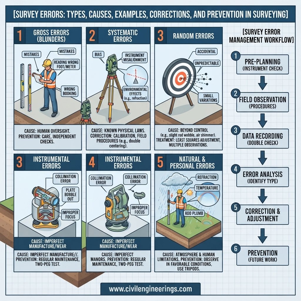
Survey Errors are unavoidable differences between observed measurements and their true or most probable values. They can arise from instruments, surveyors, environmental conditions, measurement procedures, data processing, or limitations in the observation itself. Modern technologies such as GNSS, robotic total stations, digital levels, drones, and surveying software have improved field productivity and accuracy, but they have not eliminated measurement uncertainty.
For this reason, professional surveying depends on quality control rather than assuming that every observation is perfect. Surveyors identify possible sources of error, repeat critical observations, verify control points, apply appropriate corrections, and adjust measurements when necessary.
This updated guide explains Survey Errors in practical detail, including their types, causes, examples, correction methods, modern surveying considerations, prevention techniques, quality-control procedures, and recommendations for civil engineers, surveyors, contractors, consultants, and students.
What Are Survey Errors?
Survey errors are differences between a measured or observed value and the true value, accepted value, or most probable value of a quantity.
Measurements in surveying may involve:
- Distance
- Horizontal angles
- Vertical angles
- Elevations
- Coordinates
- Bearings
- Areas
- Volumes
- Positions
No field measurement is perfectly free from uncertainty. The objective of professional surveying is therefore not simply to eliminate every error, which is impossible, but to detect, control, quantify, and reduce errors to an acceptable level.
For example, if a surveyor measures a distance several times and obtains slightly different results, the variation may represent random measurement error. On the other hand, if a tape has an incorrect standardized length, every measurement made with that tape may contain a systematic error.
Understanding this difference is essential because different errors require different solutions.
Why Survey Errors Matter in Civil Engineering
Survey information forms the basis of many engineering decisions. An inaccurate survey can affect an entire project rather than just one measurement.
Survey accuracy is particularly important for:
- Highway alignment
- Road centerline setting out
- Bridge positioning
- Building foundations
- Topographic mapping
- Drainage design
- Earthwork estimation
- Utility surveys
- Land development
- Construction staking
- Tunnel alignment
- Railway projects
- Quantity calculations
Practical Highway Example
Suppose a survey team establishes an incorrect road centerline position. The design team may use that information to prepare horizontal and vertical alignment drawings. Later, the contractor sets out the road according to those drawings.
The resulting problem could affect:
- Right-of-way requirements
- Earthwork quantities
- Drainage structures
- Property boundaries
- Utility locations
- Pavement quantities
- Intersection geometry
A small error at the survey stage can therefore become a major construction problem.
Classification of Survey Errors
Survey errors are commonly divided into three major categories:
                       Survey Errors
                            │
          ┌─────────────────┼─────────────────┐
          │                 │                 │
          ▼                 ▼                 ▼
    Gross Errors      Systematic Errors   Random Errors
          │                 │                 │
      Mistakes          Predictable        Unpredictable
Each category has different characteristics and requires a different approach to control.
1. Gross Errors
Gross errors, sometimes called blunders, are significant mistakes caused primarily by human actions.
They generally do not follow a predictable pattern and can produce much larger discrepancies than ordinary observational errors.
Common Causes
Gross errors may occur because a surveyor:
- Reads the wrong value
- Records an incorrect number
- Uses the wrong survey station
- Enters incorrect coordinates
- Misidentifies a benchmark
- Uses an incorrect backsight
- Misplaces a decimal point
- Performs an incorrect calculation
- Uses the wrong instrument setting
- Confuses field-book entries
Example
A surveyor records:
15.620 m
instead of:
16.520 m
The difference is 0.900 m, which is far too large to be considered an ordinary random variation.
How to Prevent Gross Errors
The most effective controls include:
- Independent checking
- Repeated observations
- Clear field notes
- Proper station identification
- Instrument setup verification
- Automated data logging
- Office quality-control checks
Gross errors should ideally be detected and removed rather than mathematically distributed through an adjustment.
2. Systematic Errors
Systematic errors occur according to a recognizable pattern. They tend to have a consistent magnitude or direction under similar conditions.
Unlike gross errors, systematic errors can often be calculated and corrected.
Common Causes
Examples include:
- Incorrect tape length
- Temperature effects
- Tape sag
- Incorrect instrument calibration
- Atmospheric effects
- Instrument collimation errors
- Earth curvature
- Atmospheric refraction
- Incorrect prism constant
- Scale-factor errors in electronic measurements
Example: Tape Temperature
Suppose a steel tape is standardized at 20°C but is used at a considerably higher temperature. Thermal expansion changes the actual tape length.
If the surveyor does not account for the temperature difference, the measured distance will contain a systematic error.
Important Corrections
Depending on the surveying method, corrections may include:
- Standardization correction
- Temperature correction
- Pull correction
- Sag correction
- Slope correction
- Atmospheric correction
- Curvature correction
- Refraction correction
The appropriate correction depends on the instrument, observation method, accuracy requirement, and project specifications.
3. Random Errors
Random errors are small variations that occur unpredictably during measurement.
They may be caused by:
- Observer estimation
- Minor instrument vibration
- Wind
- Atmospheric fluctuations
- Small pointing differences
- GNSS signal variation
- Slight changes in observation conditions
A random error may be positive in one observation and negative in another.
Example
A surveyor measures a horizontal angle several times and obtains:
- 42° 15′ 18″
- 42° 15′ 21″
- 42° 15′ 17″
- 42° 15′ 20″
The small differences may result from unavoidable observational variation.
How Random Errors Are Controlled
Random errors can be reduced by:
- Repeating observations
- Taking balanced measurements
- Averaging suitable observations
- Using precise instruments
- Increasing observation quality
- Applying statistical adjustment techniques
They cannot normally be eliminated completely.
Sources of Survey Errors
Another useful classification considers the source of the error.
                Sources of Survey Errors
                         │
       ┌─────────────────┼─────────────────┐
       │                 │                 │
       ▼                 ▼                 ▼
 Instrumental        Personal           Natural
    Errors            Errors             Errors
Instrumental Errors
Instrumental errors originate from imperfections, incorrect adjustment, calibration problems, or physical limitations of surveying equipment.
Examples include:
- Incorrect tape length
- Collimation error
- Poor level adjustment
- Damaged tripod
- Faulty compensator
- Incorrect prism constant
- GNSS antenna problems
- EDM calibration issues
- Battery or electronic faults
Prevention
Survey equipment should be:
- Regularly inspected
- Properly calibrated
- Carefully transported
- Correctly adjusted
- Stored in suitable conditions
Before beginning critical work, surveyors should perform the instrument checks required by the manufacturer’s procedures and project specifications.
Personal Errors
Personal errors result from the surveyor’s observation, judgment, handling, or recording.
Common examples include:
- Incorrect centering
- Poor leveling
- Incorrect focusing
- Parallax
- Wrong staff reading
- Poor target pointing
- Incorrect station identification
- Recording mistakes
- Calculation errors
Prevention
Training and standardized procedures are extremely important.
A survey team should clearly define:
- Who sets up the instrument
- Who holds the prism or staff
- Who records observations
- Who checks measurements
- Who processes the data
Good teamwork reduces communication-related mistakes.
Natural Errors
Natural errors result from environmental and physical conditions.
Common influences include:
- Temperature
- Wind
- Humidity
- Atmospheric pressure
- Refraction
- Poor visibility
- Heat shimmer
- Magnetic conditions
- Ground movement
- Solar conditions
Example
Strong heat over an asphalt road can create atmospheric shimmer. This may make precise target sighting more difficult during certain observations.
Similarly, dense vegetation, buildings, bridges, and other obstructions can affect GNSS signal reception.
Survey Errors in Modern GNSS and Total Station Work
Modern surveying has introduced new technologies but also new error sources.
GNSS/GPS Survey Errors
GNSS measurements may be affected by:
- Multipath
- Satellite geometry
- Atmospheric delay
- Obstructions
- Poor correction data
- Loss of satellite lock
- Incorrect coordinate reference systems
- Antenna setup errors
A GNSS receiver may produce highly precise-looking coordinates while still being referenced to the wrong datum or coordinate system.
Therefore, surveyors should verify:
- Coordinate reference system
- Datum
- Geoid model where applicable
- Control points
- Correction source
- Antenna height
- Observation duration
Total Station Errors
Total station surveys can be affected by:
- Incorrect centering
- Poor leveling
- Prism constant errors
- Collimation
- Incorrect backsight
- Target movement
- Atmospheric conditions
- Instrument calibration
A wrong backsight orientation is particularly important because it can affect an entire set of measured points.
Common Examples of Survey Errors
| Survey Activity | Possible Error | Typical Cause |
|---|---|---|
| Distance measurement | Incorrect distance | Tape calibration or temperature |
| Leveling | Wrong elevation | Staff reading or instrument error |
| Angle measurement | Incorrect angle | Centering or pointing error |
| GNSS survey | Coordinate shift | Multipath or poor satellite geometry |
| Total station | Position error | Incorrect backsight |
| Compass survey | Bearing error | Magnetic interference |
| Topographic survey | Wrong feature location | Coding or observation mistake |
| Construction setting out | Offset error | Incorrect reference point |
These examples demonstrate why independent checks are essential in engineering surveying.
Important Surveying Corrections
Different measurements require different correction procedures.
Temperature Correction
For steel tape measurements, temperature affects tape length.
A simplified relationship is:
[
C_t = \alpha (T-T_0)L
]
Where:
- (C_t) = temperature correction
- (\alpha) = coefficient of thermal expansion
- (T) = field temperature
- (T_0) = standard temperature
- (L) = measured length
The sign and application of the correction depend on the measurement condition.
Slope Correction
Distances measured along a slope are longer than their horizontal equivalents.
For a measured slope distance (S) and vertical difference (h), the horizontal distance can be expressed as:
[
D=\sqrt{S^2-h^2}
]
This correction is particularly important in topographic and route surveys.
Curvature and Refraction
For long sight distances, the curvature of the Earth affects observed elevations. Atmospheric refraction partially offsets this effect.
These effects become increasingly important as sight lengths increase and must be considered according to the accuracy requirements of the survey.
Survey Adjustment Techniques
After observations have been checked, acceptable discrepancies may remain in a survey network or traverse. Adjustment techniques distribute these discrepancies according to an appropriate mathematical model.
Bowditch Rule
The Bowditch or Compass Rule is commonly used for balancing ordinary closed traverses.
It distributes closing error in proportion to the length of each traverse side.
It is particularly useful where distance and angle observations have reasonably comparable relative precision.
Transit Rule
The Transit Rule distributes corrections based on the latitude and departure of the individual traverse lines.
It may be considered when angular measurements are regarded as relatively more reliable than distance measurements.
Least Squares Adjustment
Least Squares Adjustment is widely used in modern control surveying and network adjustment.
It determines the most probable values of unknown quantities by minimizing the weighted sum of squared residuals.
It is particularly useful for:
- GNSS control networks
- High-precision surveys
- Large engineering projects
- Deformation monitoring
- Complex survey networks
Modern surveying software can perform these calculations, but the surveyor must still understand the underlying observations, constraints, residuals, and quality indicators.
Practical Examples of Survey Errors
Example 1: Highway Centerline Survey
A highway survey team observes that the calculated closing coordinates do not satisfy the project’s required tolerance.
Possible Cause
The total station was incorrectly oriented to the backsight.
Corrective Action
The team should:
- Verify the control points.
- Recheck instrument centering.
- Confirm the backsight.
- Repeat the observations.
- Recalculate the traverse.
- Review the closure against project tolerances.
Construction should not proceed from questionable control data.
Example 2: Leveling Survey
A leveling run produces an unexpected difference when it returns to a known benchmark.
Possible Causes
- Staff reading error
- Poor instrument setup
- Unequal sight lengths
- Incorrect benchmark identification
Corrective Action
Repeat the leveling run using appropriate balancing and checking procedures.
Example 3: GNSS Survey Near Buildings
A GNSS receiver produces unstable positions near tall buildings.
Cause
Multipath and signal obstruction.
Solution
Move to an unobstructed location where possible, improve observation conditions, and verify the result against reliable control.
Example 4: Tape Measurement in Hot Weather
A steel tape produces slightly different results during hot and cool periods.
Cause
Thermal expansion.
Solution
Measure under controlled conditions where practical and apply the appropriate temperature correction when required.
How to Minimize Survey Errors
Although errors cannot be completely eliminated, a structured quality-control system can significantly reduce their impact.
1. Use Calibrated Equipment
Important equipment includes:
- Total stations
- Digital and automatic levels
- GNSS receivers
- EDM systems
- Steel tapes
- Prisms and accessories
Calibration records should be maintained for equipment used on critical engineering work.
2. Perform Pre-Survey Checks
Before fieldwork:
- Inspect the instrument.
- Check batteries.
- Inspect tripods.
- Verify prisms.
- Confirm instrument settings.
- Check control information.
- Review the survey plan.
3. Establish Reliable Control
A survey is only as reliable as its control framework.
Control points should be:
- Properly identified
- Stable
- Protected
- Independently checked
- Suitable for the required accuracy
Permanent benchmarks and control monuments should be protected throughout construction.
4. Repeat Critical Observations
Important measurements should not depend on a single observation when project accuracy requirements demand independent verification.
Repeated measurements can reveal:
- Gross errors
- Unstable observations
- Instrument problems
- Environmental influences
5. Balance Field Procedures
Where applicable, balanced sight lengths and suitable observation geometry can reduce systematic effects, particularly in precise leveling.
Good field geometry often improves accuracy without requiring more expensive equipment.
6. Check Data Before Leaving the Site
This is one of the most valuable practices in surveying.
Before leaving:
- Review field observations.
- Check closures.
- Verify control points.
- Confirm station names.
- Check unusual readings.
- Back up digital files.
Finding an error while the team is still at the site is usually far easier than discovering it several days later.
Survey Quality Control in 2026
Modern surveying projects increasingly combine traditional field procedures with digital quality assurance.
Current workflows may include:
- GNSS network corrections
- Robotic total stations
- Digital levels
- UAV photogrammetry
- LiDAR
- Cloud-based survey data
- Automated field coding
- BIM coordination
- Digital terrain models
- Machine-control data
These technologies can improve productivity, but they also introduce additional requirements for data management.
For example, a surveyor should verify that the field device, office software, design model, and machine-control system all use compatible coordinate systems, units, datums, and reference information.
Automation reduces repetitive work, but it does not replace professional verification.
Best Practices for Survey Error Management
A professional survey workflow should include three levels of checking.
Field Quality Control
- Instrument setup check
- Control-point verification
- Repeat observations
- Closure checks
- Field-note review
Office Quality Control
- Coordinate verification
- Adjustment review
- Data consistency checks
- Drawing comparison
- Surface inspection
Independent Verification
For critical projects, an independent survey or check measurement can confirm the primary survey results.
This is particularly valuable for:
- Major highways
- Bridges
- Tunnels
- Railways
- High-rise construction
- Property boundaries
- Primary control networks
Common Mistakes That Increase Survey Errors
Survey teams should avoid:
- Skipping instrument checks
- Using outdated control points
- Ignoring calibration records
- Failing to verify backsight orientation
- Recording observations carelessly
- Neglecting environmental conditions
- Relying on one observation for critical work
- Mixing coordinate systems
- Entering incorrect antenna or prism heights
- Forgetting correction factors
- Leaving the site without checking closures
- Using unverified digital data for construction
A major lesson in professional surveying is simple: do not allow an unchecked observation to become a construction fact.
Practical Recommendations for Civil Engineers
Civil engineers should:
- Review survey control before approving design data.
- Confirm that survey accuracy meets project requirements.
- Investigate unexpected elevations or coordinates.
- Coordinate survey requirements with designers.
- Request independent checks for critical work.
- Ensure survey information uses the correct coordinate reference system.
Practical Recommendations for Highway Engineers and Consultants
Highway professionals should establish survey accuracy requirements before fieldwork begins.
They should also:
- Define control-point standards.
- Specify required observation procedures.
- Review calibration documentation.
- Require closure checks.
- Verify horizontal and vertical control independently.
- Maintain survey records throughout construction.
- Protect established benchmarks and monuments.
For major infrastructure, survey quality should be treated as part of the project’s overall quality assurance system.
Practical Recommendations for Contractors
Contractors should:
- Verify setting-out points before construction.
- Protect control monuments.
- Check benchmarks before excavation.
- Confirm offsets and elevations.
- Report discrepancies immediately.
- Avoid disturbing established survey control.
- Maintain records of construction surveys.
Contractors should never proceed with major excavation or structural work based on a questionable setting-out point.
Practical Recommendations for Civil Engineering Students
Students should develop both theoretical and practical surveying skills.
Focus on:
- Instrument setup
- Leveling
- Traversing
- Total station operation
- GNSS fundamentals
- Error classification
- Corrections
- Traverse adjustment
- Coordinate calculations
- Field-note preparation
Students should also learn how surveying errors affect actual construction. Understanding the consequences makes surveying concepts much easier to remember.
IRC, AASHTO, and ICE: General Engineering Guidance
International engineering organizations emphasize accurate surveying, reliable control, documentation, and quality assurance as essential parts of infrastructure development.
Indian Roads Congress (IRC) publications provide guidance relevant to highway surveys, geometric design, road projects, and transportation infrastructure in India.
AASHTO provides extensive guidance relating to highway surveying, geometric design, transportation engineering, construction, and asset development in the United States and internationally referenced practice.
Institution of Civil Engineers (ICE) provides professional knowledge and engineering guidance covering infrastructure, surveying-related practice, transportation, construction, and project delivery.
The exact survey accuracy, equipment requirements, tolerances, control procedures, and adjustment methods should always be determined from the applicable project specifications, national standards, authority requirements, and current editions of relevant technical documents.
Frequently Asked Questions
1. What are Survey Errors?
Survey Errors are differences between observed measurements and their true, accepted, or most probable values. They can result from instruments, surveyors, environmental conditions, measurement procedures, or data processing.
2. What are the three main types of survey errors?
The three commonly recognized categories are gross errors, systematic errors, and random errors. Each category has different characteristics and requires different methods of control.
3. Can survey errors be completely eliminated?
No. Measurement uncertainty cannot be eliminated completely. However, careful procedures, calibrated instruments, repeated observations, appropriate corrections, and statistical adjustment can reduce errors to acceptable levels.
4. What causes systematic errors in surveying?
Systematic errors can result from incorrect instrument calibration, tape length, temperature, atmospheric conditions, curvature, refraction, prism constants, or other effects that follow a predictable pattern.
5. How can random errors be reduced?
Random errors can be reduced by repeating observations, improving measurement conditions, using suitable instruments, balancing observations, and applying appropriate statistical methods.
6. Why is calibration important in surveying?
Calibration helps verify that instruments perform within their required accuracy. It can identify systematic instrument errors before they affect critical measurements.
7. What is the Bowditch Rule?
The Bowditch Rule is a traverse adjustment method that distributes closing errors among traverse lines in proportion to their lengths. It is commonly used for ordinary closed traverses.
8. What is the purpose of Least Squares Adjustment?
Least Squares Adjustment determines the most probable values of survey quantities by statistically processing observations and minimizing weighted residuals. It is widely used for precise control and complex survey networks.
9. What causes GNSS survey errors?
GNSS measurements can be influenced by multipath, satellite geometry, atmospheric effects, signal obstruction, correction-data problems, antenna setup, and incorrect coordinate reference systems.
10. Why are survey errors important in highway construction?
Highway design depends on accurate coordinates, elevations, alignment, terrain information, and quantities. Survey errors can therefore affect road geometry, earthwork, drainage, pavement construction, structures, and project costs.
Conclusion
Survey Errors are an unavoidable part of measurement, but their effects can be controlled through sound surveying practice, appropriate technology, and rigorous quality assurance. Gross errors must be detected and removed, systematic errors should be identified and corrected where possible, and random errors can be reduced through repeated observations and statistical methods.
For modern civil engineering projects, survey accuracy extends beyond simply reading an instrument correctly. Survey teams must establish reliable control, verify coordinate systems, maintain calibrated equipment, check GNSS and total station observations, protect benchmarks, review field data, and confirm results before transferring information into design or construction.
The increasing use of GNSS, robotic total stations, UAVs, LiDAR, digital terrain models, BIM, and automated data processing has made surveying faster and more powerful. However, technology does not eliminate the need for engineering judgment. Incorrect setup, poor control, wrong coordinate systems, or unverified data can still produce serious errors.
Whether you are a civil engineering student, surveyor, highway engineer, consultant, contractor, or infrastructure professional, understanding Survey Errors is essential for delivering accurate designs, reliable construction layouts, safer infrastructure, and better project outcomes. A strong survey quality-control process ultimately saves time, reduces rework, controls costs, and protects the integrity of the entire engineering project.

I’m really impressed with your writing skills and also with the layout on your blog.
Is this a paid theme or did you customize it yourself?
Anyway keep up the nice quality writing, it’s rare to see a great blog like this one today.