
Introduction
Road projects depend on accurate survey information from the earliest alignment study to final as-built documentation. Traditional ground surveys remain essential, but long highway corridors, steep terrain, active traffic, large earthwork areas, and difficult-to-access locations can make conventional surveying slow and resource-intensive. This is where a Drone Survey for Roads can add significant value.
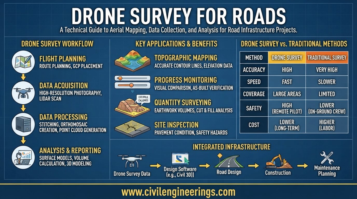
A drone survey combines unmanned aerial systems (UAS), GNSS positioning, photogrammetry, LiDAR, and specialized processing software to capture detailed information across a road corridor. Engineers can transform aerial images into orthomosaic maps, point clouds, digital elevation models, contours, cross-sections, and three-dimensional terrain models.
The technology is particularly useful for road alignment studies, topographic surveys, earthwork measurement, construction monitoring, drainage assessment, right-of-way mapping, slope inspection, and as-built documentation. However, good results do not come simply from flying a drone. Survey control, flight planning, camera settings, ground sampling distance, terrain conditions, processing quality, and independent accuracy checks all matter.
This guide explains the engineering principles, workflow, applications, accuracy considerations, limitations, formulas, and best practices for using drone technology in modern road and highway projects.
What Is a Drone Survey for Roads?
A Drone Survey for Roads is an aerial surveying method in which an unmanned aerial vehicle captures georeferenced photographs or LiDAR measurements along a road corridor. Surveyors process this information to produce accurate two-dimensional and three-dimensional engineering datasets.
Unlike ordinary aerial photography, engineering drone surveying focuses on measurable spatial information. The objective is not merely to obtain attractive photographs but to create data that engineers can use for design, quantity calculations, inspection, planning, and project control.
A typical road drone survey may combine:
- UAV or UAS platform
- RGB mapping camera
- LiDAR sensor where appropriate
- RTK or PPK GNSS positioning
- Ground Control Points (GCPs)
- Checkpoints
- Photogrammetry software
- CAD and GIS software
- Digital Elevation Models (DEMs)
- Digital Surface Models (DSMs)
- Digital Terrain Models (DTMs)
- Orthomosaic imagery
- 3D point clouds
- Contour maps and cross-sections
The Indian Roads Congress recognizes photogrammetry as useful to highway engineering, including mapping, contouring, profiles, and cross-sections. (Indian Registry for Internet Names)
The important distinction is that a drone becomes a surveying instrument only when the entire workflow is controlled and validated. An aerial image without a reliable coordinate system or accuracy assessment is not automatically suitable for engineering design.
Why Use Drones in Road and Highway Projects?


Faster Corridor Data Collection
Roads are linear infrastructure. A project may extend for several kilometres or hundreds of kilometres, making repetitive ground measurements difficult.
A drone can rapidly capture large areas while maintaining systematic image overlap. This is especially useful during preliminary surveys, construction monitoring, and periodic progress documentation.
Improved Surveyor Safety
Survey crews working close to live traffic face significant risks. Drones can collect many types of visual and spatial information without requiring personnel to stand continuously within traffic-exposed areas.
This does not eliminate fieldwork. Surveyors still need to establish control, verify critical points, inspect conditions, and perform measurements where aerial methods cannot provide sufficient confidence.
Caltrans, for example, identifies surveying, photogrammetry, construction monitoring, and emergency inspections among transportation-related UAS applications. (Caltrans)
Better Visualization
Traditional survey points can be difficult for non-survey personnel to visualize. Drone-derived orthomosaics and 3D models provide an intuitive representation of the actual site.
Project managers can compare:
Existing ground → Design → Construction progress → As-built condition
This makes communication among engineers, contractors, consultants, and clients easier.
Repeatable Monitoring
A road construction site changes continuously. Repeated drone flights can establish a historical record of earthworks, embankments, pavement construction, structures, stockpiles, and drainage works.
When flights use consistent control and processing methods, engineers can compare datasets from different dates.
Major Applications of Drone Survey for Roads
1. Preliminary Road Alignment Survey
Drone mapping can support reconnaissance and preliminary route assessment by showing:
- Existing roads
- Buildings
- Rivers and drainage channels
- Agricultural areas
- Slopes
- Vegetation
- Utility corridors
- Existing structures
- Terrain constraints
- Possible right-of-way conflicts
The resulting terrain model can help engineers evaluate alternative alignments before detailed design.
Drone data should complement, rather than replace, geotechnical investigations, hydrological studies, property surveys, and other required investigations.
2. Topographic Survey
One of the most important applications is generating detailed topographic information.
Typical outputs include:
- Spot elevations
- Contours
- Breaklines
- Terrain models
- Existing ground profiles
- Cross-sections
- Drainage features
- Road edges
- Embankments
- Cut slopes
IRC’s road-project survey manual emphasizes that survey and investigation requirements vary according to project size, scope, and highway class. (Indian Registry for Internet Names)
3. Road Corridor Mapping
Drone corridor mapping can capture the road and surrounding right-of-way in a single georeferenced dataset.
Engineers can map:
- Carriageways
- Medians
- Shoulders
- Service roads
- Intersections
- Culverts
- Drains
- Signage
- Utility poles
- Buildings
- Boundary features
- Encroachments
- Slopes
This creates a valuable base map for highway planning and asset management.
4. Earthwork and Cut-and-Fill Calculation
Drone-derived terrain models can be compared with design surfaces to calculate earthwork quantities.
For cross-sectional or average-end-area calculations:
Where:
- = volume
- = distance between sections
- = area of first cross-section
- = area of second cross-section
For example, if two sections have areas of 120 m² and 180 m² and are 50 m apart:
Modern software can also calculate volumes directly from surfaces and point clouds.
For contractual quantities, however, the survey methodology, coordinate system, surface definition, and acceptance criteria should be agreed with the client or engineer before measurement.
5. Construction Progress Monitoring
Regular drone surveys can provide objective evidence of construction progress.
A project team can compare:
- Planned versus actual earthwork
- Completed embankment
- Excavated areas
- Subgrade preparation
- Pavement layers
- Structures
- Drainage works
- Temporary facilities
- Material stockpiles
Aerial progress records can also support monthly reports and project meetings.
6. Road Asset and Condition Documentation
High-resolution imagery can document visible defects and roadside assets.
Depending on the sensor and survey objective, engineers may identify:
- Cracking
- Edge deterioration
- Potholes
- Rutting indicators
- Damaged shoulders
- Drainage blockage
- Erosion
- Landslides
- Damaged signs
- Guardrails
- Culverts
Visual identification should not automatically be treated as a substitute for detailed pavement condition testing or structural evaluation.
7. Bridges, Culverts, and Drainage Structures
Drones are particularly useful where physical access is difficult.
They can help document:
- Bridge decks
- Approaches
- Pier areas
- Abutments
- Culvert entrances
- Drainage channels
- Scour areas
- Embankment erosion
- Difficult-to-access slopes
AASHTO published UAS guidance in 2026 addressing the use of drones for bridge inspection and the consistency of element-level data collection. (AASHTO Journal)
8. Landslide and Slope Monitoring
Road corridors in mountainous terrain often experience:
- Rockfalls
- Landslides
- Erosion
- Embankment failures
- Drainage-induced instability
Repeated photogrammetric or LiDAR surveys can provide surface models for comparing terrain changes.
For critical slopes, drone data should form part of a broader geotechnical monitoring system rather than being the sole source of engineering judgment.
How Drone Survey for Roads Works
Step 1: Define the Survey Objective
Start with the engineering question.
Do you need:
- Alignment data?
- Topographic mapping?
- Earthwork quantities?
- Construction progress?
- Pavement documentation?
- Drainage mapping?
- As-built verification?
- Slope monitoring?
The required accuracy and sensor selection depend heavily on the objective.
Step 2: Define the Survey Corridor
Determine:
- Road centreline
- Required survey width
- Project limits
- Ground elevation range
- Structures
- Vegetation
- Restricted areas
- Nearby buildings
- Power lines
- Airspace constraints
A wider corridor may be required around interchanges, curves, drainage structures, junctions, or proposed widening areas.
Step 3: Establish Ground Control
Ground Control Points provide known coordinates that connect the aerial dataset to the required survey reference system.
Good GCP planning should consider:
- Horizontal distribution
- Vertical distribution
- Corridor length
- Terrain variation
- Visibility
- Accessibility
- Survey accuracy
Independent checkpoints should preferably be retained for accuracy verification rather than using every surveyed point as a processing control point.
Research on corridor photogrammetry has shown that both the number and distribution of GCPs influence accuracy, with alternating points on opposite sides of the corridor producing strong results in the studied configuration. (MDPI)
Step 4: Plan the Drone Flight
Important parameters include:
- Flight altitude
- Ground Sample Distance (GSD)
- Image overlap
- Flight speed
- Camera angle
- Corridor direction
- Terrain variation
- Lighting conditions
- Battery capacity
- Airspace restrictions
A basic relationship for ground sampling distance is:
Where:
- = camera-to-ground distance
- = physical pixel size of the camera sensor
- = focal length
Lower GSD generally means finer image detail, but increasing resolution may increase flight time, image volume, and processing requirements.
Step 5: Capture Overlapping Images
Photogrammetry requires sufficient overlap between images so software can identify common features.
The exact overlap should be selected according to the camera, terrain, flight configuration, and processing requirements. Engineers should avoid relying on a universal percentage without considering the actual project.
Step 6: Process the Dataset
Photogrammetry software identifies common features between photographs and reconstructs the surveyed surface.
Typical processing stages include:
- Image quality checking
- Camera calibration
- Image alignment
- Bundle adjustment
- GCP integration
- Point-cloud generation
- Surface reconstruction
- Orthomosaic generation
- DEM/DSM/DTM creation
- Accuracy assessment
- CAD/GIS extraction
The final dataset can then be exported for engineering use.
Photogrammetry vs LiDAR for Road Surveys


Drone Photogrammetry
Photogrammetry uses overlapping photographs to reconstruct three-dimensional geometry.
Advantages include:
- High-resolution visual imagery
- Excellent documentation
- Generally lower equipment cost
- Strong performance in open terrain
- Orthomosaic production
- Useful colour information
It performs particularly well where the ground is visible and contains sufficient image texture.
Drone LiDAR
LiDAR measures distances using laser pulses and can produce dense three-dimensional point clouds.
It can be advantageous in:
- Vegetated corridors
- Forested areas
- Complex terrain
- Slopes
- Certain structural surveys
- Bare-earth extraction beneath partial vegetation
However, LiDAR does not automatically guarantee better results for every road project. Sensor quality, trajectory accuracy, calibration, point density, terrain, and processing methodology all influence final accuracy.
Which Should Engineers Choose?
A practical decision is:
Open terrain + strong visual requirements → Photogrammetry
Vegetated terrain + bare-earth requirements → Consider LiDAR
Complex project → Consider a combined workflow
The correct choice should always follow the required deliverables and accuracy specification rather than the popularity of a particular technology.
Accuracy of Drone Road Surveys
Accuracy is one of the most misunderstood aspects of drone surveying.
A statement such as “the drone provides centimetre accuracy” is incomplete. Accuracy depends on:
- GSD
- Camera quality
- Lens calibration
- RTK/PPK performance
- GCP quality
- Checkpoint distribution
- Satellite geometry
- Flight conditions
- Image overlap
- Terrain
- Processing settings
- Surface characteristics
- Survey control
Relative and Absolute Accuracy
Relative accuracy describes how consistently features relate to each other within the model.
Absolute accuracy describes how closely the model agrees with the real-world coordinate reference system.
A dataset may look extremely accurate visually while still containing a systematic coordinate error.
Accuracy Verification
Use independent checkpoints wherever project requirements demand formal verification.
Common statistical measures include RMSE:
Where:
- = individual error
- = number of observations
The acceptable tolerance should come from the project specification, survey standard, client requirements, and intended engineering application.
Deliverables from a Road Drone Survey
A professional drone survey can produce several engineering deliverables.
2D Deliverables
- Orthomosaic
- Topographic map
- Contour map
- Road inventory
- Utility mapping
- Right-of-way map
- Drainage map
3D Deliverables
- Dense point cloud
- DSM
- DTM
- TIN surface
- 3D mesh
- Terrain model
Engineering Deliverables
- Longitudinal profiles
- Cross-sections
- Cut-and-fill maps
- Volume reports
- Alignment verification
- Progress maps
- As-built drawings
- GIS layers
- CAD-ready files
The deliverable format should be agreed before fieldwork begins. There is little value in producing a technically impressive point cloud that the design team cannot efficiently use.
Common Challenges and Limitations
Vegetation
Dense vegetation can hide the actual ground surface from optical photogrammetry. LiDAR may provide a better solution where bare-earth terrain is required.
Weather
Strong wind, rain, dust, fog, and poor lighting can affect flight safety and data quality.
Active Traffic
Flying near operational highways requires careful risk management. Survey teams must follow applicable aviation, transportation, site-safety, and traffic-control requirements.
Power Lines and Obstacles
Power lines, towers, cranes, trees, signs, and structures can create serious flight hazards.
Data Volume
High-resolution surveys generate large datasets. Adequate storage, processing hardware, backup procedures, and data-management systems are essential.
Legal and Regulatory Requirements
Drone operations must comply with the aviation regulations and permissions applicable to the project location. Transportation agencies may also impose additional requirements.
AASHTO has highlighted the growing transportation use of UAS for surveying, mapping, construction support, inspection, and monitoring while also emphasizing the importance of safe and authorized operations. (AASHTO Journal)
Best Practices for Drone Survey for Roads
Students
- Learn basic photogrammetry and surveying principles.
- Understand coordinate systems and datums.
- Study GSD and image overlap.
- Learn how GCPs and checkpoints work.
- Practice interpreting DEMs, DTMs, and point clouds.
- Do not assume an attractive aerial image is an engineering survey.
Engineers and Consultants
- Define accuracy requirements before the flight.
- Establish a suitable survey control network.
- Use independent checkpoints.
- Document equipment and processing methodology.
- Compare drone results against conventional measurements for critical features.
- Maintain consistent workflows for repeat surveys.
- Specify deliverable formats in the contract.
- Review the final surface for gaps, artefacts, vegetation errors, and incorrect elevations.
Contractors
- Conduct baseline surveys before major earthworks.
- Repeat surveys at agreed milestones.
- Compare measured quantities with design surfaces.
- Maintain dated survey records.
- Use aerial progress information to support project reporting.
- Keep original datasets and processing records for traceability.
The strongest workflow is not drone instead of surveying. It is drone technology integrated with professional surveying and engineering control.
IRC, AASHTO, and ICE Considerations
Drone surveying should not be treated as a standalone replacement for established highway engineering practice.
IRC
For projects following Indian Roads Congress practice, IRC:SP:19-2020, Manual for Survey, Investigation and Preparation of Road Projects, provides an important framework for road surveys and investigations. IRC material also discusses photogrammetry applications in highway engineering. (Indian Registry for Internet Names)
IRC continues to update its highway standards and guidance, so engineers should verify the current edition applicable to the project. (Indian Registry for Internet Names)
AASHTO
AASHTO publications and guidance can provide useful transportation-sector references, particularly for UAS applications, bridge inspection, data quality, and operational considerations. Its 2026 UAS bridge-inspection guidance specifically addresses program development, personnel, equipment, methodology, and data infrastructure. (AASHTO Journal)
ICE
The Institution of Civil Engineers and other professional engineering bodies provide broader principles for surveying, geospatial engineering, infrastructure design, project management, and professional responsibility. Drone-derived information should therefore be incorporated into the project’s approved survey and engineering quality-management procedures.
The key principle across all standards is simple: technology does not replace engineering judgment, survey control, or project specifications.
Future of Drone Surveying in Highway Engineering
Drone surveying is moving beyond simple aerial photography.
Future highway workflows increasingly combine:
- RTK/PPK positioning
- AI-assisted image interpretation
- LiDAR
- Photogrammetry
- GIS
- BIM
- Digital twins
- Automated change detection
- Machine-learning-based asset inspection
- Cloud collaboration
- Automated volume calculations
A road corridor can eventually become a continuously updated digital representation rather than a collection of isolated survey drawings.
This direction is already reflected in transportation practice. AASHTO has noted the expanding role of UAS in transportation inspection, surveying, construction support, and monitoring. (AASHTO Journal)
The engineering value will come not from flying more often, but from integrating reliable spatial data into design, construction, maintenance, and asset-management decisions.
Frequently Asked Questions About Drone Survey for Roads
1. What is a Drone Survey for Roads?
It is an aerial surveying method that uses drones equipped with cameras or LiDAR sensors to collect georeferenced information for road planning, mapping, construction, inspection, and monitoring.
2. Can drones replace traditional road surveying?
No. Drones can reduce field effort and improve coverage, but conventional GNSS, total stations, control surveys, geotechnical investigations, and field verification remain necessary for many engineering applications.
3. What data can a road drone survey produce?
Common outputs include orthomosaics, point clouds, DEMs, DTMs, DSMs, contours, profiles, cross-sections, 3D models, volume calculations, CAD data, and GIS layers.
4. How accurate is drone surveying for highways?
Accuracy varies with the equipment, GSD, RTK/PPK, GCPs, terrain, processing workflow, and quality-control procedures. Accuracy should always be demonstrated against independent checkpoints and project tolerances.
5. Is LiDAR better than photogrammetry for road surveys?
Neither is universally better. Photogrammetry works well in open terrain with strong visual detail, while LiDAR can offer advantages in vegetation and complex terrain. Some projects benefit from combining both.
6. Can drones calculate road construction quantities?
Yes. Drone-derived surfaces can be compared with design or previous survey surfaces to calculate excavation, embankment, stockpile, and other earthwork quantities.
7. Can drones survey active highways?
They can be used around highway infrastructure where legally and operationally permitted, but flight planning must address aviation rules, traffic safety, obstacles, site risks, and agency requirements.
8. What are GCPs in drone surveying?
Ground Control Points are accurately surveyed points used to improve the georeferencing and positional accuracy of a photogrammetric model. Independent checkpoints can then be used to evaluate accuracy.
9. How often should a road construction site be surveyed by drone?
There is no universal interval. Weekly, biweekly, monthly, or milestone-based surveys may be appropriate depending on construction speed, contract requirements, earthwork activity, and reporting needs.
10. Is drone surveying useful for road maintenance?
Yes. Repeated aerial surveys can document road assets, drainage conditions, slope changes, erosion, construction defects, and other visible changes. Critical defects should still receive appropriate ground inspection and engineering evaluation.
Conclusion
A Drone Survey for Roads has become a powerful tool for modern highway engineering because it connects aerial data capture with practical engineering decisions. When properly planned, a drone can rapidly document large corridors, generate detailed terrain models, support alignment studies, measure earthwork, monitor construction, inspect difficult locations, and produce valuable as-built records.
The greatest benefit does not come from the drone itself. It comes from combining the UAV platform with sound surveying principles, reliable GNSS control, appropriate GCPs, suitable photogrammetry or LiDAR technology, rigorous processing, and independent accuracy verification.
For students, drone surveying offers an important connection between traditional surveying and digital engineering. Consultants and highway engineers, it provides a practical way to improve project visualization and data collection. For contractors, it can strengthen progress monitoring and quantity verification.
The most effective road projects will therefore treat drone mapping as part of an integrated surveying and engineering workflow—not as a replacement for professional judgment. With appropriate quality control and standards-based procedures, aerial surveying can make road planning, construction, inspection, and asset management faster, safer, and more data-driven.
