
Right of Way (ROW) in Highway Engineering
Road transportation infrastructure extends far beyond the pavement that vehicles travel on. Every highway, expressway, or local road requires sufficient land to accommodate not only the carriageway but also future expansion, drainage systems, utility corridors, pedestrian facilities, and roadside safety features. This reserved land is known as the Right of Way (ROW).
In Highway Engineering, the Right of Way is a fundamental planning and design element that directly influences road safety, operational efficiency, environmental sustainability, and long-term infrastructure development. A properly planned ROW provides enough space for present transportation needs while allowing flexibility for future improvements without costly land acquisition.
Whether designing a rural highway, an urban arterial road, or a controlled-access expressway, engineers must carefully determine the required ROW based on traffic demand, terrain, land use, and applicable design standards.
This guide explains the concept of Right of Way (ROW), its importance, classification, engineering principles, width requirements, influencing factors, and practical applications in modern Road Engineering.
What Is Right of Way (ROW)?
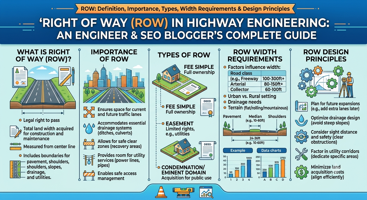
The Right of Way (ROW) refers to the total strip of land reserved for constructing, operating, maintaining, and expanding a roadway and its associated facilities. It includes the carriageway as well as all supporting infrastructure required for safe and efficient transportation.
Unlike the pavement width, which only represents the area used by vehicles, the ROW encompasses a much broader corridor that may include shoulders, medians, sidewalks, drainage channels, slopes, utility lines, landscaping, and future widening space.
In simple terms:
- Carriageway = Portion used by vehicles.
- Roadway = Carriageway plus shoulders.
- Right of Way = Entire land reserved for the transportation corridor.
The ROW establishes the legal boundary within which highway authorities can construct and manage transportation infrastructure.
Why Right of Way Is Important in Highway Engineering
A well-planned Right of Way supports the long-term performance and sustainability of road infrastructure. Insufficient ROW often results in costly land acquisition, traffic congestion, utility conflicts, and limited opportunities for future expansion.
Key Benefits
1. Accommodates Future Road Widening
Traffic volumes generally increase over time. Providing adequate ROW during the initial project stage allows additional lanes to be constructed without relocating adjacent properties.
2. Improves Road Safety
Extra roadside space provides room for recovery areas, guardrails, medians, clear zones, and pedestrian facilities, reducing accident severity.
3. Supports Utility Installation
Utilities such as water pipelines, sewer networks, electrical cables, fiber-optic lines, and gas pipelines can be installed within the ROW without affecting traffic operations.
4. Enhances Drainage
Adequate space allows engineers to construct side drains, culverts, stormwater channels, and erosion-control measures that protect the pavement from water damage.
5. Reduces Future Costs
Although acquiring additional land initially may increase project costs, it significantly reduces expenses associated with future widening and reconstruction.
Objectives of Providing Right of Way
The primary objectives of ROW planning include:
- Reserving sufficient land for road infrastructure.
- Ensuring safe traffic movement.
- Providing space for roadside drainage.
- Accommodating pedestrians and cyclists.
- Allowing installation of public utilities.
- Supporting future transportation improvements.
- Minimizing conflicts with adjacent developments.
- Protecting roadside environments.
Proper ROW planning contributes to efficient project implementation and long-term operational success.
Components Included Within a Right of Way
A typical Right of Way contains several infrastructure elements in addition to the pavement.
These may include:
- Carriageway
- Shoulders
- Median
- Sidewalks
- Bicycle lanes
- Service roads
- Roadside drains
- Embankments
- Side slopes
- Guardrails
- Lighting poles
- Traffic signs
- Utility corridors
- Landscaping strips
- Noise barriers
- Future widening reserve
The exact configuration depends on the road classification, traffic demand, and surrounding environment.
Types of Right of Way
1. Permanent Right of Way
Permanent ROW refers to land acquired for the entire operational life of the highway.
It accommodates permanent infrastructure such as:
- Pavement
- Bridges
- Medians
- Side drains
- Utility corridors
- Roadside safety features
This land remains under the control of the highway authority.
2. Temporary Right of Way
Temporary ROW is acquired only during the construction phase.
It may be used for:
- Equipment movement
- Material storage
- Temporary access roads
- Construction camps
- Diversion routes
After project completion, this land is restored and returned according to contractual or legal requirements.
3. Controlled Right of Way
Controlled ROW is commonly associated with expressways and access-controlled highways.
Within this corridor:
- Unauthorized access is restricted.
- Entry and exit occur only at designated interchanges.
- Encroachments are prohibited.
- Adjacent developments are regulated.
Controlled ROW enhances safety by minimizing conflict points and maintaining uninterrupted traffic flow.
Factors Affecting Right of Way Width
Determining the appropriate ROW width requires balancing engineering, environmental, economic, and social considerations.
1. Road Classification
Higher-order roads generally require wider ROW.
Examples include:
- Expressways
- National highways
- Urban arterials
- Rural highways
- Local streets
Major highways often need additional land for medians, service roads, and future lane additions.
2. Traffic Volume
Projected traffic demand influences both pavement width and future expansion needs.
Roads expected to carry heavy traffic require larger ROW to accommodate additional lanes and auxiliary facilities.
3. Terrain
Topography significantly affects ROW requirements.
Flat Terrain
Requires comparatively less land.
Rolling Terrain
Needs additional space for drainage and grading.
Mountainous Terrain
Requires wider corridors for cut slopes, retaining walls, and rockfall protection.
4. Side Slopes
Road embankments and cut sections require stable side slopes, increasing the total land requirement.
Steeper slopes demand more horizontal space, especially in weak soils.
5. Drainage Requirements
Road drainage facilities occupy considerable space within the ROW.
Typical drainage features include:
- Side drains
- Culverts
- Retention ponds
- Stormwater channels
Proper drainage protects the pavement structure and surrounding land.
6. Future Expansion
Modern highway projects reserve sufficient land for:
- Additional traffic lanes
- Dedicated bus lanes
- Bicycle infrastructure
- Utility corridors
- Intelligent transportation systems (ITS)
Planning for future needs avoids expensive property acquisition later.
7. Urban vs Rural Conditions
Urban ROW planning is constrained by existing buildings, utilities, and property values.
Rural highways generally allow wider corridors due to lower land acquisition costs and greater land availability.
Typical Right of Way Cross-Section
The following simplified diagram illustrates how various road elements fit within a typical ROW.
Property Line
│
──────────────────────────────────────────────────────────────
 Drain | Shoulder | Carriageway | Median | Carriageway | Shoulder | Drain
──────────────────────────────────────────────────────────────
Utility Corridor     Footpath        Landscaping
│
Property Line
The arrangement varies depending on highway classification, design speed, terrain, and local planning requirements.
Land Acquisition Principles
Land acquisition is an essential step in establishing the Right of Way. Engineers collaborate with planners, surveyors, and government authorities to define corridor boundaries while minimizing social and environmental impacts.
Key Principles
Accurate Surveying
Topographic and cadastral surveys establish existing property boundaries, terrain characteristics, and infrastructure.
Fair Compensation
Property owners affected by the project should receive compensation in accordance with applicable laws and regulations.
Environmental Considerations
ROW planning should seek to reduce impacts on wetlands, forests, agricultural land, and ecologically sensitive areas.
Community Impact
Designers should minimize displacement of homes, businesses, schools, and public facilities whenever practical.
Future Planning
Acquiring sufficient land during the initial project phase often proves more economical than acquiring additional property after urban development has occurred.
Engineering Considerations for Right of Way (ROW) Planning
Planning an effective Right of Way (ROW) requires more than allocating land. Highway engineers must integrate geometric design, traffic forecasting, environmental protection, utility coordination, and future infrastructure needs into a single corridor plan. Careful planning at the design stage minimizes operational issues and reduces lifecycle costs.
1. Geometric Design Compatibility
The ROW should provide adequate space for all geometric design elements, including:
- Horizontal curves
- Vertical curves
- Sight distance requirements
- Intersections
- Interchanges
- Turning lanes
Restricted land often forces designers to compromise on geometry, which may reduce safety and traffic efficiency.
2. Traffic Growth Forecasting
Traffic demand rarely remains constant throughout a road’s service life. Engineers typically estimate traffic growth over a design period of 20 to 30 years.
When determining ROW width, planners should consider:
- Population growth
- Urban expansion
- Industrial development
- Commercial activity
- Freight movement
- Public transportation needs
Providing additional space today is usually far less expensive than acquiring developed land decades later.
3. Utility Coordination
Modern transportation corridors accommodate numerous public utilities. Proper planning prevents future conflicts during maintenance and road expansion.
Typical utilities include:
- Water supply pipelines
- Sewer lines
- Natural gas pipelines
- Electrical transmission cables
- Telecommunications networks
- Fiber-optic infrastructure
- Street lighting systems
Utility corridors should be positioned to allow repairs without disrupting traffic or damaging pavement.
4. Environmental Protection
Highway projects should balance infrastructure development with environmental sustainability.
Important considerations include:
- Preserving natural drainage patterns
- Minimizing tree removal
- Protecting wetlands and water bodies
- Reducing soil erosion
- Controlling construction dust and noise
- Providing wildlife crossings where necessary
Integrating environmental measures within the ROW helps reduce long-term ecological impacts.
5. Road Safety Features
Adequate ROW enables the installation of essential roadside safety infrastructure.
Examples include:
- Crash barriers
- Guardrails
- Clear recovery zones
- Traffic signs
- Lighting poles
- Emergency stopping areas
- Median barriers
Providing sufficient roadside clearance can significantly reduce the severity of vehicle crashes.
Practical Applications of Right of Way
The required ROW varies depending on the road’s function, surrounding development, and expected traffic volume.
Urban Roads
Urban corridors often include:
- Carriageways
- Sidewalks
- Bicycle lanes
- Bus stops
- Utility ducts
- Street lighting
- Parking lanes
- Landscaping
Limited land availability makes efficient corridor planning especially important in cities.
Rural Highways
Rural roads generally require wider corridors for:
- Side slopes
- Drainage channels
- Future lane expansion
- Agricultural access
- Utility installations
Lower development density often simplifies land acquisition.
Expressways
Access-controlled highways require the widest ROW because they accommodate:
- Multiple carriageways
- Wide medians
- Service roads
- Interchanges
- Toll plazas
- Intelligent Transportation Systems (ITS)
- Noise barriers
- Emergency facilities
These additional features support higher travel speeds and improve overall safety.
Real-World Example
Consider a proposed four-lane divided highway connecting two growing cities.
During the planning phase, engineers identify that traffic demand is expected to double within 25 years. Instead of acquiring land only for the initial four lanes, the project reserves additional ROW for:
- Two future traffic lanes
- A dedicated public transport corridor
- Underground utility services
- Wider drainage facilities
- Landscape buffers
Although the initial land acquisition cost is higher, the reserved corridor eliminates the need for property demolition and major disruptions when future expansion becomes necessary. This approach demonstrates sound engineering practice and long-term planning.
Engineering Best Practices
Successful ROW planning relies on technical expertise, coordination among stakeholders, and adherence to established engineering principles.
Recommended practices include:
- Conduct detailed topographic and cadastral surveys before finalizing alignment.
- Forecast traffic growth using reliable demographic and transportation data.
- Preserve adequate space for drainage and utility corridors.
- Coordinate with local authorities during the planning stage.
- Minimize displacement of residential and commercial properties.
- Protect environmentally sensitive areas wherever feasible.
- Provide sufficient roadside clear zones to improve safety.
- Reserve land for future widening and multimodal transportation facilities.
- Maintain clear legal documentation of acquired land.
- Perform regular inspections to prevent unauthorized encroachments.
Applying these practices helps create transportation corridors that remain functional, safe, and adaptable for decades.
Practical Recommendations
Civil and Highway Engineers
- Design ROW based on projected long-term traffic demand rather than current conditions.
- Integrate roadway geometry, drainage, and utility planning from the earliest design stages.
- Consider future technologies such as electric vehicle charging infrastructure and smart traffic systems.
- Coordinate closely with surveyors, environmental specialists, and urban planners.
Contractors
- Respect established ROW boundaries during construction.
- Avoid storing materials outside approved work zones.
- Protect existing utilities and drainage facilities.
- Restore temporarily occupied land after project completion.
- Implement erosion and sediment control measures throughout construction.
Engineering Students
- Understand the distinction between carriageway width, roadway width, and Right of Way.
- Study road cross-sections and alignment plans to see how ROW accommodates multiple infrastructure elements.
- Familiarize yourself with surveying techniques used to establish property boundaries.
- Learn how traffic forecasting influences long-term corridor planning.
Developing a strong understanding of ROW concepts is essential for careers in transportation planning, highway design, and infrastructure management.
General Discussion on IRC and AASHTO Recommendations
Highway agencies around the world rely on established engineering standards to determine appropriate ROW requirements.
IRC (Indian Roads Congress)
IRC publications provide guidance on:
- Highway planning
- Geometric design
- Rural and urban road standards
- Road safety
- Drainage
- Land requirements for transportation corridors
The recommended ROW varies depending on road classification, terrain, traffic volume, and anticipated future development.
AASHTO (American Association of State Highway and Transportation Officials)
AASHTO emphasizes a comprehensive approach to corridor planning by considering:
- Design speed
- Functional classification
- Traffic projections
- Safety clear zones
- Utility accommodation
- Environmental constraints
- Future roadway improvements
Although exact dimensions differ across jurisdictions, both IRC and AASHTO encourage reserving sufficient land to support safe operation, efficient maintenance, and future expansion of highway facilities.
Frequently Asked Questions (FAQs)
1. What is Right of Way (ROW) in road engineering?
Right of Way (ROW) is the total land reserved for constructing, operating, maintaining, and expanding a roadway along with its associated facilities such as drainage systems, utilities, medians, and sidewalks.
2. Why is Right of Way important in Highway Engineering?
ROW provides space for safe road operation, future widening, drainage infrastructure, utility services, pedestrian facilities, and roadside safety features. It also reduces the need for expensive land acquisition during future upgrades.
3. How is ROW different from the carriageway?
The carriageway is the portion of the road used by moving vehicles, while the Right of Way includes the entire transportation corridor, encompassing shoulders, medians, footpaths, drainage systems, utility corridors, and reserved land.
4. What factors determine the width of a Right of Way?
ROW width depends on road classification, projected traffic volume, terrain, drainage requirements, side slopes, surrounding land use, environmental considerations, and future expansion plans.
5. Can utilities be installed within the Right of Way?
Yes. Water pipelines, sewer networks, electrical cables, gas lines, and communication infrastructure are commonly placed within designated utility corridors inside the ROW.
6. What happens if the Right of Way is too narrow?
An inadequate ROW can limit future road expansion, create conflicts with utilities, reduce safety, complicate maintenance, and increase long-term project costs due to additional land acquisition.
7. Is the Right of Way the same for all highways?
No. The required ROW varies according to the road’s functional classification, traffic demand, terrain, urban or rural setting, and applicable engineering standards.
Conclusion
The Right of Way (ROW) is one of the most important planning elements in Highway Engineering, providing the land needed not only for the roadway itself but also for drainage, utilities, safety features, pedestrian facilities, and future expansion. A well-planned ROW improves operational efficiency, enhances road safety, reduces maintenance challenges, and supports sustainable infrastructure development.
Successful ROW planning requires careful evaluation of traffic growth, terrain, environmental conditions, and community needs. By integrating sound engineering principles with thoughtful long-term planning, engineers can create transportation corridors that remain functional and adaptable for decades. Whether you are a practicing engineer, contractor, or student, understanding the role of Right of Way is fundamental to delivering resilient and future-ready road infrastructure in modern Road Engineering.

Kamran Malik is a passionate civil engineering writer and researcher who specializes in construction, transportation, structural engineering, and infrastructure topics. Through his articles on CivilEngineerings.com, he simplifies complex engineering concepts and shares practical insights, industry trends, and educational resources for students, professionals, and engineering enthusiasts.