
Introduction
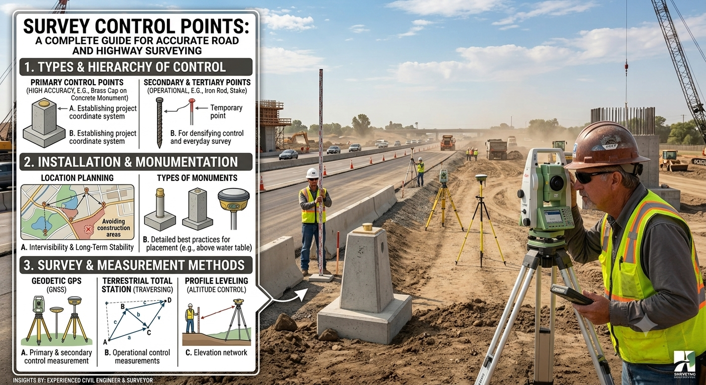
Every successful road or highway project begins with precise surveying. Engineers cannot design a safe alignment, prepare accurate drawings, or construct durable infrastructure without reliable reference points. This is where Survey Control Points become essential. These fixed reference markers provide the positional accuracy required throughout the planning, design, construction, and maintenance phases of a project.
Survey control points create a consistent framework for all measurements. They allow survey teams to establish coordinates, elevations, and boundaries with confidence. Without these reference points, small measurement errors can accumulate and lead to alignment problems, construction delays, increased costs, and safety concerns.
In road engineering, survey control points guide every activity, from route selection and topographic surveys to earthwork calculations and bridge construction. They ensure that all project stakeholders work from the same reference system, improving accuracy and reducing costly mistakes.
This guide explains Survey Control Points in detail, including their types, importance, establishment methods, engineering principles, practical applications, and best practices. Whether you are a civil engineering student, site engineer, surveyor, or contractor, understanding survey control points will strengthen your knowledge of modern highway engineering.
What Are Survey Control Points?
Survey Control Points are fixed physical reference points with accurately known coordinates and elevations. Surveyors establish these points before collecting detailed field data. Every subsequent measurement refers back to these locations.
Control points create a common coordinate system across the entire project. They ensure that every survey team produces consistent results regardless of the survey date or personnel involved.
In highway engineering, survey control points support:
- Route surveys
- Topographic mapping
- Highway alignment
- Bridge construction
- Earthwork calculations
- Drainage design
- Utility relocation
- Construction layout
- As-built surveys
Without a reliable control network, survey accuracy decreases significantly, increasing the risk of construction errors.
Why Survey Control Points Matter
Survey control points serve as the backbone of every engineering survey. They provide a dependable reference framework that improves precision and consistency.
Major Benefits
Accurate Positioning
Control points establish exact horizontal and vertical positions for all project features.
Improved Construction Accuracy
Engineers can transfer design coordinates from drawings to the field with confidence.
Better Quality Control
Repeated measurements from the same control points allow engineers to verify construction accuracy throughout the project.
Reduced Survey Errors
A properly designed control network minimizes cumulative measurement errors.
Efficient Collaboration
Designers, surveyors, contractors, and inspectors work within the same coordinate reference system, reducing misunderstandings.
Types of Survey Control Points
Survey control points are classified according to the information they provide and their role within the survey network.
Horizontal Control Points
Horizontal control points define positions in the horizontal plane using X and Y coordinates or latitude and longitude.
These points help establish:
- Road centerlines
- Property boundaries
- Curve locations
- Intersection layouts
- Bridge locations
Horizontal Control Methods
Surveyors commonly establish horizontal control using:
- GNSS/GPS observations
- Traverse surveys
- Triangulation
- Trilateration
- Total Station measurements
Practical Example
During the planning of a four-lane highway, surveyors establish horizontal control points every few hundred meters along the proposed corridor. These points guide the layout of the road centerline and ensure accurate alignment during construction.
Vertical Control Points
Vertical control points provide elevation information relative to a recognized datum.
Engineers use these points to determine:
- Road grades
- Embankment heights
- Cut and fill quantities
- Drainage slopes
- Bridge deck elevations
- Culvert inverts
Establishing Vertical Control
Common methods include:
- Differential leveling
- Digital leveling
- GNSS leveling (where appropriate)
- Trigonometric leveling
Importance in Road Projects
Accurate elevation data ensures:
- Proper drainage
- Safe gradients
- Balanced earthworks
- Stable pavement performance
Primary, Secondary, and Tertiary Control Points
Survey projects often use a hierarchical control system.
Primary Control Points
Primary control forms the highest level of accuracy within the project.
Characteristics include:
- Highest precision
- Permanent monuments
- Long-term stability
- Large project coverage
These points normally connect to national geodetic networks.
Secondary Control Points
Secondary control extends the primary network into individual project sections.
Engineers use these points for:
- Detailed topographic surveys
- Highway alignment
- Utility surveys
- Preliminary design work
Secondary control maintains high accuracy while reducing surveying effort.
Tertiary Control Points
Surveyors establish tertiary control close to active construction areas.
These points support:
- Construction staking
- Earthwork layout
- Pavement construction
- Structural positioning
Although they offer slightly lower precision than primary control, they provide sufficient accuracy for day-to-day construction activities.
Permanent and Temporary Control Points
Control points can also be classified according to their intended lifespan.
Permanent Control Points
Permanent control points remain in place for many years.
Surveyors typically install them using:
- Concrete monuments
- Brass survey markers
- Stainless steel pins
- Bedrock monuments
Advantages
- Long-term reliability
- Stable reference system
- Useful for future projects
- Reduced need for repeated surveys
Temporary Control Points
Temporary control points support short-term construction activities.
Examples include:
- Wooden stakes
- Steel rods
- Painted marks
- Survey nails
Survey teams remove or replace these points after project completion.
How Survey Control Points Are Established
Establishing survey control requires careful planning, field observations, calculations, and quality verification.
Step 1: Project Planning
Surveyors review project requirements, existing control data, mapping information, and coordinate systems.
Step 2: Reconnaissance
The survey team visits the site to identify suitable control point locations.
Good locations should provide:
- Clear visibility
- Stable ground
- Easy accessibility
- Protection from disturbance
Step 3: Monument Installation
Surveyors install permanent or temporary markers according to project requirements.
Each marker receives a unique identification number.
Step 4: Field Measurements
Survey teams measure distances, angles, and elevations using modern surveying instruments.
Measurements often include:
- GNSS observations
- Total Station traverses
- Precise leveling
Step 5: Data Processing
Engineers process field observations to calculate accurate coordinates and elevations.
They verify results using network adjustment techniques and error analysis.
Step 6: Verification
Independent checks confirm that the established control points satisfy the required accuracy standards.
Only verified control points become part of the official project control network.
Common Survey Control Markers
Surveyors use different marker types depending on project duration, terrain, and required accuracy.
Common examples include:
- Concrete monuments
- Brass disks
- Survey nails
- Steel rods
- Iron pins
- Chiseled crosses
- Painted reference marks
- Benchmarks
- Reference pillars
Each marker should remain clearly visible, protected from disturbance, and properly documented.
Survey Control Network Diagram
                 Primary Control Point
                        ●
                       / \
                      /   \
                     /     \
                    ●-------●
             Secondary     Secondary
              Control       Control
                 |\           /|
                 | \         / |
                 |  \       /  |
                 |   ●-----●   |
                 |  Tertiary   |
                 |  Control    |
                 |             |
                 ●-------------●
            Construction Layout Area
Diagram Explanation
- Primary Control Points provide the highest level of positional accuracy and anchor the entire survey network.
- Secondary Control Points extend the control framework across the project corridor.
- Tertiary Control Points support detailed construction layout, setting out, and day-to-day surveying activities near active work zones.
This hierarchical arrangement improves accuracy, simplifies field operations, and allows surveyors to detect and correct measurement errors efficiently.
Factors Affecting Survey Control Point Accuracy
Even the most advanced surveying equipment cannot guarantee accurate results without proper field procedures. Several factors influence the precision and reliability of Survey Control Points.
Instrument Accuracy
Surveyors must calibrate Total Stations, Digital Levels, GNSS receivers, and other instruments regularly. Poor calibration introduces systematic errors into every observation.
Ground Stability
Engineers should establish control points on stable ground. Soft soil, embankments, loose fill, or areas affected by erosion may shift over time and compromise accuracy.
Weather Conditions
Strong winds, heavy rainfall, extreme temperatures, and atmospheric refraction can affect measurements. Survey teams should plan fieldwork during suitable weather whenever possible.
Human Error
Incorrect instrument setup, poor centering, inaccurate readings, and recording mistakes reduce survey quality. Experienced personnel and standardized procedures help minimize these errors.
Obstructions
Buildings, trees, bridges, and overhead power lines may obstruct lines of sight or interfere with GNSS signals. Proper reconnaissance helps identify suitable locations before observations begin.
Quality Control
Engineers should verify all control points through repeated observations and independent checks. Early detection of errors prevents costly corrections during construction.
Equipment Used for Survey Control Points
Modern surveying relies on advanced instruments that provide high accuracy and improve field efficiency.
Total Station
A Total Station combines an electronic theodolite with an electronic distance measurement (EDM) system. It measures horizontal angles, vertical angles, and distances simultaneously.
Applications
- Traverse surveys
- Construction layout
- Highway alignment
- Bridge positioning
- Detail surveys
GNSS/GPS Receiver
Global Navigation Satellite System (GNSS) receivers determine accurate geographic positions using satellite signals.
Advantages
- High positional accuracy
- Faster data collection
- Reduced manpower
- Suitable for large highway corridors
- Easy integration with GIS software
Digital Level
Digital levels provide precise elevation measurements for establishing vertical control points and benchmarks.
Common Uses
- Road profile surveys
- Drainage design
- Bridge approaches
- Pavement elevation checks
Survey Tripods and Prisms
Tripods provide instrument stability, while prisms reflect EDM signals for accurate distance measurements.
Proper setup improves measurement consistency and reduces field errors.
Survey Data Collectors
Modern data collectors store field observations digitally. They reduce manual recording errors and simplify data transfer to design software.
Engineering Principles Behind Survey Control Points
Survey control networks follow established engineering principles to maintain precision and consistency throughout the project.
Redundancy
Surveyors collect multiple observations for each control point. Additional measurements help identify and eliminate errors.
Closure
Traverse and leveling loops should close within allowable tolerances. Closure checks verify the reliability of the survey.
Adjustment
Engineers perform mathematical adjustments to distribute small measurement errors across the control network, improving overall accuracy.
Traceability
Each control point should connect to recognized coordinate systems or national geodetic networks whenever practical.
Documentation
Every control point requires complete documentation, including coordinates, elevations, descriptions, photographs, and sketches.
Practical Applications of Survey Control Points in Road Engineering
Survey control points support nearly every phase of a highway project.
Route Selection
Surveyors establish control networks before carrying out topographic and alignment surveys. Accurate control helps engineers compare alternative routes with confidence.
Highway Alignment
Engineers use control points to mark the road centerline, horizontal curves, and vertical profiles.
Earthwork Operations
Control points provide reference elevations for excavation, embankment construction, and cut-and-fill calculations.
Bridge Construction
Bridge foundations, abutments, piers, and deck alignments require precise positioning. Survey control ensures that structural components fit together correctly.
Drainage Construction
Engineers rely on vertical control points to establish proper slopes for culverts, side drains, stormwater channels, and cross-drainage structures.
Utility Relocation
Survey teams use control points to accurately locate existing utilities and position relocated infrastructure.
Construction Staking
Contractors use control points to transfer design information from engineering drawings to the field.
Construction staking includes:
- Road centerline
- Shoulder edges
- Culverts
- Retaining walls
- Bridges
- Intersections
- Utility corridors
As-Built Surveys
After construction, engineers perform as-built surveys using the same control network to verify that completed works match the approved design.
Best Practices for Survey Control Points
Following best practices improves survey accuracy and reduces project risks.
- Conduct thorough reconnaissance before establishing control points.
- Select stable and easily accessible locations.
- Protect permanent monuments from construction activities.
- Use redundant observations to verify measurements.
- Calibrate surveying equipment regularly.
- Document every control point with sketches and photographs.
- Perform periodic inspections throughout construction.
- Maintain backup control points in case of accidental damage.
- Train field personnel on standardized survey procedures.
- Archive survey records for future maintenance and expansion projects.
Common Mistakes to Avoid
Many surveying problems result from avoidable errors rather than equipment limitations.
Common mistakes include:
- Establishing control points on unstable ground.
- Failing to protect monuments during construction.
- Ignoring instrument calibration schedules.
- Using inconsistent coordinate systems.
- Recording incorrect field observations.
- Skipping independent accuracy checks.
- Inadequate documentation of control points.
- Relying on a single observation instead of redundant measurements.
Avoiding these mistakes improves project quality and minimizes expensive rework.
Practical Recommendations
Civil Engineers
- Verify survey reports before approving design work.
- Ensure that all construction activities reference the approved control network.
- Review control point accuracy before major structural work begins.
Contractors
- Protect established control points throughout construction.
- Inform survey teams immediately if any control marker becomes disturbed.
- Avoid storing materials or operating heavy machinery near permanent monuments.
Surveyors
- Perform regular instrument calibration.
- Use standardized field procedures.
- Recheck control points after significant earthworks.
- Maintain detailed field notes and digital backups.
Engineering Students
- Learn both traditional and satellite-based surveying methods.
- Practice field measurements using Total Stations and Digital Levels.
- Understand coordinate systems and error adjustment techniques.
- Visit active construction sites to observe control networks in use.
General Discussion of IRC, AASHTO, and ICE Practices
Leading engineering organizations emphasize the importance of accurate survey control in infrastructure development.
IRC (Indian Roads Congress)
IRC guidance highlights detailed topographic surveys, reliable control networks, and accurate benchmarks as essential for successful highway planning and construction.
AASHTO
AASHTO promotes accurate geospatial control, quality assurance procedures, proper documentation, and dependable survey data for transportation projects.
ICE (Institution of Civil Engineers)
ICE encourages rigorous surveying practices, effective project management, continuous quality improvement, and the use of modern surveying technologies to support safe and sustainable infrastructure.
Although specific procedures differ by country, these organizations share common principles that prioritize accuracy, consistency, and documentation.
Frequently Asked Questions (FAQs)
1. What are Survey Control Points?
Survey Control Points are fixed reference markers with known coordinates and elevations that provide the basis for all engineering measurements during surveying and construction.
2. Why are Survey Control Points important in highway construction?
They ensure accurate positioning, consistent measurements, correct highway alignment, reliable earthwork calculations, and quality construction.
3. What is the difference between horizontal and vertical control points?
Horizontal control defines location in the X-Y plane, while vertical control establishes elevation relative to a known datum.
4. Which instruments establish Survey Control Points?
Surveyors commonly use GNSS receivers, Total Stations, Digital Levels, prisms, tripods, and electronic data collectors.
5. How do engineers protect permanent control points?
They install durable monuments, record precise coordinates, use protective markers, and inspect them regularly throughout the project.
6. What happens if a control point is disturbed?
Surveyors verify nearby control points, re-establish the damaged point using approved survey procedures, and update project records before continuing construction.
7. Can GNSS replace traditional surveying methods?
GNSS provides excellent positional accuracy for many applications. However, engineers often combine GNSS with Total Stations and precise leveling to achieve the highest accuracy in complex highway projects.
8. How often should survey equipment be calibrated?
Calibration intervals depend on project requirements and manufacturer recommendations, but engineers should inspect and verify equipment regularly to maintain measurement accuracy.
9. What is a benchmark in surveying?
A benchmark is a permanent vertical control point with a precisely known elevation used as a reference for leveling operations.
10. Why is redundancy important in survey control?
Redundant observations allow surveyors to detect mistakes, validate measurements, and improve the reliability of the entire control network.
Conclusion
Survey Control Points form the foundation of every successful road and highway project. They provide the positional and elevation references needed for planning, design, construction, and long-term maintenance. From establishing highway alignments to setting bridge foundations and verifying completed works, these reference points ensure that every engineering activity follows a consistent and accurate coordinate system. Modern instruments such as GNSS receivers, Total Stations, and Digital Levels have significantly improved surveying efficiency, yet skilled field procedures, careful documentation, and rigorous quality control remain equally important. Engineers, contractors, and surveyors should establish stable control networks, protect permanent monuments, perform regular verification, and maintain complete records throughout the project lifecycle. By following recognized engineering practices and understanding the importance of Survey Control Points, infrastructure professionals can reduce errors, improve construction quality, optimize project costs, and deliver safe, durable transportation facilities that serve communities for decades.
