
Introduction
Modern highway projects are becoming larger, more complex, and more demanding than ever before. Governments, consultants, and contractors are expected to deliver safer roads, reduce construction costs, minimize delays, and maintain infrastructure throughout its entire life cycle. Traditional design methods often struggle to manage the enormous amount of engineering data generated during planning, surveying, design, construction, and maintenance.
This is where Highway BIM has transformed the transportation industry. Building Information Modeling (BIM) is no longer limited to buildings. It has evolved into a powerful digital engineering process for highways, expressways, bridges, tunnels, and transportation infrastructure. By integrating intelligent 3D models with engineering data, scheduling, costing, and asset management, BIM enables project teams to collaborate more effectively while reducing errors and improving decision-making.
This comprehensive guide explains everything you need to know about Highway BIM. You’ll learn its definition, principles, workflow, components, benefits, software applications, implementation process, engineering standards, challenges, future trends, and industry best practices. Whether you’re a civil engineering student, highway engineer, contractor, consultant, or infrastructure professional, this article will help you understand why BIM is becoming the foundation of modern road engineering.
What is Highway BIM?
Highway BIM refers to the application of Building Information Modeling technologies and workflows to infrastructure projects. Instead of creating disconnected drawings, engineers develop an intelligent digital model containing geometry, engineering properties, material specifications, quantities, schedules, costs, maintenance information, and operational data.
Unlike conventional CAD drawings, BIM creates a centralized information model where every design modification automatically updates related drawings, quantities, profiles, and documentation.
The BIM model acts as a digital representation of the highway throughout its complete life cycle—from feasibility studies to demolition or rehabilitation.
Why Highway BIM Matters
Transportation projects involve multiple stakeholders, including:
- Highway Engineers
- Surveyors
- Geotechnical Engineers
- Structural Engineers
- Contractors
- Utility Agencies
- Government Authorities
- Environmental Consultants
Without a centralized information platform, communication gaps can lead to:
- Design conflicts
- Quantity errors
- Construction delays
- Cost overruns
- Safety risks
- Poor documentation
BIM addresses these issues by creating a single source of project information that all stakeholders can access and update.
Evolution of BIM in Highway Engineering
Initially, BIM was developed for building projects. As infrastructure projects became increasingly digital, highway agencies recognized the value of intelligent modeling.
Today, BIM supports:
- Highway corridors
- Urban roads
- Rural highways
- Interchanges
- Bridges
- Culverts
- Tunnels
- Retaining structures
- Drainage systems
- Intelligent Transportation Systems (ITS)
Many transportation agencies now encourage or require BIM workflows for major infrastructure projects.
Core Principles of BIM
Intelligent 3D Modeling
The highway is modeled as an intelligent object rather than simple lines and curves.
Each component contains engineering information such as:
- Material type
- Layer thickness
- Elevation
- Pavement properties
- Design standards
- Construction sequence
Data Integration
BIM integrates data from numerous engineering disciplines including:
- Topographic surveys
- GIS
- LiDAR
- Drone surveys
- Geotechnical investigations
- Utility mapping
- Environmental studies
- Traffic engineering
This integration significantly reduces duplicate work.
Collaboration
All project participants work within a coordinated environment.
Design revisions become visible immediately, reducing communication delays and improving project coordination.
Lifecycle Management
Unlike traditional drawings,BIM remains useful after construction.
The digital model supports:
- Inspection
- Maintenance
- Rehabilitation
- Asset management
- Future expansion
Main Components of Highway BIM
A complete BIM model generally includes:
- Existing terrain model
- Digital elevation model (DEM)
- Corridor alignment
- Horizontal alignment
- Vertical profile
- Typical cross-sections
- Pavement layers
- Earthworks
- Bridges
- Drainage structures
- Culverts
- Signage
- Road markings
- Guardrails
- Utilities
- Landscaping
- Traffic management systems
Each object stores engineering parameters that improve project management.
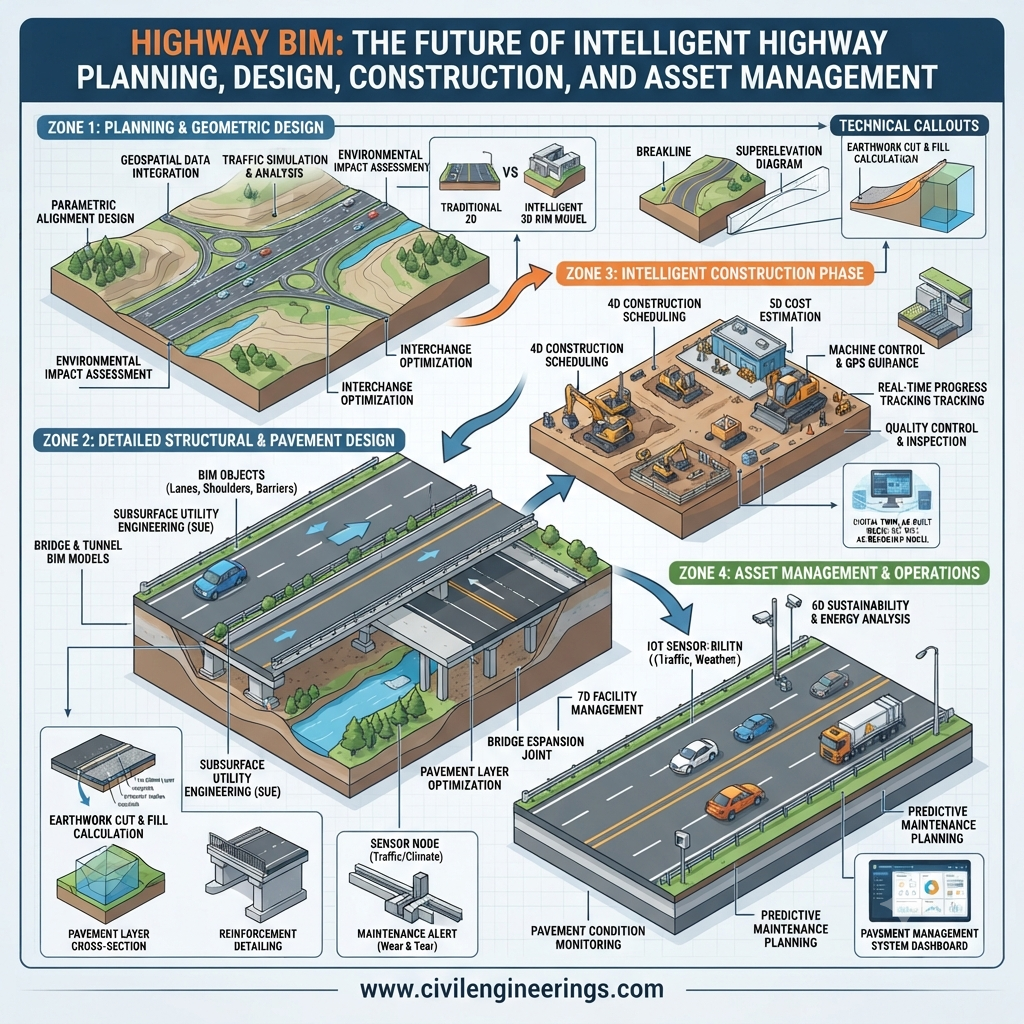
Highway BIM Workflow
A typical BIM workflow consists of several coordinated stages.
1. Site Investigation
The project begins with:
- Topographic surveys
- Drone mapping
- LiDAR scanning
- Utility surveys
- Soil investigation
- Environmental assessments
2. Existing Conditions Modeling
Collected survey information is converted into a digital terrain model.
This serves as the base model for highway design.
3. Highway Geometry Design
Engineers create:
- Horizontal alignment
- Vertical alignment
- Cross-sections
- Superelevation
- Intersections
- Interchanges
4. Corridor Modeling
The roadway corridor is generated automatically by combining alignments with design templates.
The software updates corridor geometry whenever alignment changes occur.
5. Clash Detection
BIM software identifies conflicts involving:
- Drainage pipes
- Utilities
- Bridge foundations
- Retaining walls
- Existing infrastructure
Resolving clashes before construction reduces expensive field modifications.
6. Quantity Takeoff
The BIM model automatically calculates:
- Earthwork volumes
- Pavement quantities
- Concrete
- Reinforcement
- Drainage items
This improves cost estimation accuracy.
7. Construction Simulation
4D BIM combines:
- Construction schedule
- Equipment planning
- Temporary works
- Resource allocation
Project managers visualize construction progress before work begins.
8. Asset Management
After project completion, the BIM model supports maintenance planning throughout the highway’s operational life.
Levels and Dimensions of BIM
Modern BIM extends beyond three-dimensional modeling.
3D BIM
Visual representation of physical highway elements.
4D BIM
Construction scheduling linked to the model.
5D BIM
Cost estimation and quantity management.
6D BIM
Sustainability and lifecycle analysis.
7D BIM
Facility management and long-term maintenance.
Together, these dimensions improve planning and operational efficiency.
Applications of Highway BIM
BIM is used throughout transportation engineering.
Major applications include:
- Highway planning
- Route selection
- Earthwork optimization
- Pavement design
- Bridge integration
- Drainage design
- Utility coordination
- Environmental analysis
- Traffic management
- Construction sequencing
- Digital inspections
- Highway maintenance
- Asset management
- Smart infrastructure
Software Used in Highway BIM
Common software platforms include:
- Autodesk Civil 3D
- Autodesk InfraWorks
- Bentley OpenRoads Designer
- Bentley ProjectWise
- Navisworks
- Revit (for related structures)
- Synchro 4D
- ArcGIS
- Trimble Quadri
- Tekla Structures (bridges)
Many organizations combine multiple software platforms to create a complete BIM ecosystem.
Highway BIM vs Traditional Highway Design
| Feature | Traditional Design | Highway BIM |
|---|---|---|
| Design Method | 2D Drawings | Intelligent 3D Models |
| Collaboration | Limited | Real-time Coordination |
| Quantity Calculation | Manual | Automated |
| Clash Detection | During Construction | Before Construction |
| Documentation | Separate Files | Centralized Database |
| Asset Management | Limited | Full Lifecycle |
| Visualization | Basic | Advanced Digital Models |
| Design Updates | Manual | Automatic |
Engineering Standards and Guidelines
Although requirements differ across countries, BIM commonly aligns with principles from recognized engineering organizations such as:
- IRC (Indian Roads Congress) for highway planning and design guidance.
- AASHTO (American Association of State Highway and Transportation Officials) for geometric design, transportation standards, and asset management practices.
- ICE (Institution of Civil Engineers) for digital engineering, project collaboration, and infrastructure delivery.
Many public agencies are also adopting ISO 19650 principles for BIM information management across infrastructure projects.
Practical Example of BIM
Consider the construction of a 75-kilometer divided highway.
Using BIM, engineers first create a digital terrain model from drone surveys and LiDAR data. Designers then develop the highway alignment, cross-sections, bridges, culverts, drainage systems, and retaining walls within a coordinated model.
Utility conflicts are detected before construction starts. Automated quantity takeoffs provide accurate estimates for excavation, embankment, pavement, and concrete works. Construction teams use 4D simulations to optimize equipment movement and scheduling. After project completion, the owner receives a digital asset model containing maintenance records and inspection data, simplifying long-term highway management.
Benefits of Highway BIM
BIM delivers measurable advantages across every project phase.
Key benefits include:
- Improved collaboration
- Better design accuracy
- Reduced construction errors
- Faster project delivery
- Enhanced visualization
- Accurate quantity estimation
- Lower project costs
- Improved safety planning
- Better stakeholder communication
- Reduced rework
- Easier document management
- Efficient maintenance planning
- Stronger asset management
- Increased sustainability
- Better lifecycle decision-making
Challenges of Highway BIM Implementation
Despite its advantages, implementation presents several challenges.
Common issues include:
- High software costs
- Training requirements
- Resistance to organizational change
- Large data management needs
- Hardware requirements
- Interoperability between software platforms
- Lack of standardized workflows
- Initial productivity reduction during transition
Organizations typically overcome these challenges through phased adoption, structured training, and clear BIM execution plans.
Best Practices
Successful BIM projects usually follow these recommendations:
- Develop a BIM Execution Plan (BEP) before design begins.
- Define roles and responsibilities for every discipline.
- Maintain consistent naming conventions and data standards.
- Conduct regular model coordination meetings.
- Perform clash detection at scheduled milestones.
- Keep models updated with approved revisions.
- Integrate GIS, survey, and geotechnical data early.
- Train project teams on BIM workflows and collaboration tools.
- Use cloud-based common data environments for document control.
- Plan for asset management from the earliest project stages.
Future of Highway BIM
The future of Highway BIM extends beyond digital design. Emerging technologies such as Artificial Intelligence (AI), Machine Learning, Digital Twins, Internet of Things (IoT), autonomous construction equipment, cloud collaboration, and real-time sensor integration are reshaping highway infrastructure management.
Digital twins connected to BIM models will enable engineers to monitor pavement performance, traffic flow, bridge health, and maintenance needs in real time. Predictive analytics will help agencies prioritize repairs before failures occur, reducing lifecycle costs and improving public safety. As smart transportation systems expand, BIM will become a cornerstone of sustainable, data-driven infrastructure development.
Frequently Asked Questions (FAQs)
1. What is Highway BIM?
BIM is the application of Building Information Modeling to highway planning, design, construction, operation, and maintenance using intelligent digital models.
2. How is Highway BIM different from CAD?
CAD primarily creates drawings, while BIM combines intelligent 3D models with engineering data, schedules, quantities, costs, and lifecycle information.
3. Which professionals use Highway BIM?
Civil engineers, surveyors, contractors, consultants, project managers, government agencies, and infrastructure owners all benefit from BIM.
4. Which software is commonly used for Highway BIM?
Popular tools include Autodesk Civil 3D, Bentley OpenRoads Designer, InfraWorks, Navisworks, Synchro, ArcGIS, and ProjectWise.
5. Does Highway BIM reduce construction costs?
Yes. Early clash detection, automated quantity takeoffs, better coordination, and optimized construction planning help reduce unnecessary costs and rework.
6. Can Highway BIM improve highway maintenance?
Yes. A BIM model stores asset information that supports inspections, maintenance scheduling, rehabilitation planning, and lifecycle management.
7. Is BIM suitable for small road projects?
While the greatest value is seen on large and complex infrastructure projects, BIM principles can also improve coordination and documentation on smaller road schemes.
8. What is 5D BIM in highway engineering?
5D BIM links cost information with the digital model, enabling dynamic quantity estimation, budgeting, and cost control as the design evolves.
9. What role does GIS play in BIM?
GIS provides geographic and spatial context, while BIM delivers detailed engineering information. Together they improve planning, analysis, and asset management.
10. What skills should engineers develop for BIM?
Engineers should strengthen their knowledge of highway geometry, BIM workflows, digital surveying, GIS integration, data management, model coordination, and software such as Civil 3D or OpenRoads Designer.
Conclusion
Highway BIM is transforming the way transportation infrastructure is planned, designed, built, and maintained. By combining intelligent 3D models with engineering data, scheduling, cost estimation, and lifecycle asset management, it creates a collaborative digital environment that improves efficiency and reduces project risks. From route selection and corridor design to clash detection, construction sequencing, and long-term maintenance, Highway BIM supports informed decision-making at every stage of a project’s life cycle.
For civil engineering students, mastering BIM opens the door to modern digital engineering careers. For consultants, contractors, and government agencies, adopting BIM leads to better coordination, higher-quality project delivery, and more sustainable infrastructure. As technologies such as digital twins, AI, IoT, and cloud collaboration continue to evolve, the role of BIM will become even more significant. Organizations that invest in BIM capabilities today will be better positioned to deliver resilient, cost-effective, and future-ready networks that meet the growing demands of modern transportation.

Kamran Malik is a passionate civil engineering writer and researcher who specializes in construction, transportation, structural engineering, and infrastructure topics. Through his articles on CivilEngineerings.com, he simplifies complex engineering concepts and shares practical insights, industry trends, and educational resources for students, professionals, and engineering enthusiasts.