
Introduction
Highway Alignment Design forms the foundation of every successful road and highway project. Before engineers prepare pavement designs or begin construction, they determine the safest, most economical, and environmentally suitable route. A well-designed highway alignment reduces construction costs, improves driving comfort, enhances road safety, and minimizes future maintenance expenses. Poor alignment, on the other hand, creates sharp curves, steep gradients, drainage issues, and accident-prone locations that affect the highway throughout its service life.
Modern highway alignment design combines transportation engineering, surveying, geotechnical engineering, environmental planning, hydrology, and traffic engineering. Engineers evaluate terrain, traffic demand, soil conditions, existing infrastructure, and environmental constraints before selecting the final route. Every decision influences construction cost, operating efficiency, and long-term performance.
This comprehensive guide explains the principles, objectives, types, and engineering factors involved in Highway Alignment Design, making it a valuable resource for civil engineers, contractors, engineering students, and highway professionals.
What is Highway Alignment Design?
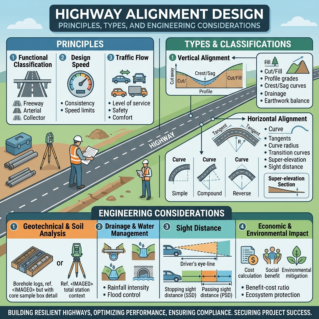
Highway Alignment Design is the engineering process of selecting the most suitable route and geometric layout for a highway. It defines the highway’s position on the ground, its horizontal direction, vertical profile, and cross-sectional configuration to ensure safe, efficient, and economical transportation.
A highway alignment consists of three main components:
- Horizontal Alignment
- Vertical Alignment
- Cross-Sectional Elements
The alignment must provide a smooth driving experience while accommodating expected traffic volumes, design speeds, and future expansion.
Simple Highway Alignment Diagram
             PLAN VIEW (Horizontal Alignment)

Start
  │
  │
  ├───────────────╮
  │               │
  │               ╰───────────────╮
  │                               │
  ╰────────────────────────────────► End


          PROFILE VIEW (Vertical Alignment)

Elevation
   ▲
   │        Crest Curve
   │        /\
   │       /  \______
   │______/           \____ Sag Curve
   └──────────────────────────────► Distance
The horizontal alignment controls the road’s direction, while the vertical alignment defines changes in elevation. Together, they create a safe and comfortable roadway.
Why Highway Alignment Design is Important
Selecting the correct highway alignment is one of the most critical decisions in highway engineering. Once construction begins, changing the route becomes expensive and technically challenging.
An efficient alignment provides long-term benefits by improving traffic operations and reducing lifecycle costs.
Benefits of Good Highway Alignment Design
- Improves road safety
- Reduces construction costs
- Minimizes earthwork
- Enhances driving comfort
- Shortens travel distance where practical
- Improves fuel efficiency
- Reduces vehicle operating costs
- Supports future traffic growth
- Minimizes environmental impacts
- Simplifies maintenance activities
Poor alignment often results in:
- Frequent accidents
- Reduced visibility
- Excessive excavation
- Drainage problems
- High maintenance costs
- Increased travel time
Objectives of Highway Alignment Design
Every highway alignment should achieve several engineering objectives simultaneously.
1. Safety
The alignment must provide adequate sight distance, gentle curves, and safe gradients to reduce accident risks.
2. Economy
Engineers aim to minimize construction, operation, and maintenance costs without compromising quality.
3. Comfort
Smooth horizontal and vertical transitions improve ride quality and reduce driver fatigue.
4. Efficiency
The alignment should support the desired design speed and maintain uninterrupted traffic flow.
5. Sustainability
Modern highway projects minimize environmental impacts while preserving natural resources and ecosystems.
6. Future Expansion
Engineers consider future traffic growth and reserve sufficient right-of-way for widening when necessary.
Principles of Highway Alignment Design
Successful highway alignments follow established engineering principles that balance safety, functionality, and cost.
Directness
The highway should connect destinations using the shortest practical route while avoiding unnecessary detours.
Safety
Designers provide adequate visibility, smooth curves, and appropriate gradients to reduce collision risks.
Consistency
Drivers expect uniform roadway characteristics. Sudden changes in alignment or design speed create confusion and increase accident potential.
Economy
Engineers balance initial construction costs with long-term maintenance and operational expenses.
Drainage
The alignment should facilitate efficient surface and subsurface drainage to protect pavement layers and embankments.
Environmental Compatibility
Designers avoid environmentally sensitive areas whenever practical and incorporate mitigation measures where impacts cannot be avoided.
Types of Highway Alignment
Highway alignment consists of three interrelated components.
1. Horizontal Alignment
Horizontal alignment defines the roadway’s direction when viewed from above.
It consists of:
- Straight sections (Tangents)
- Circular curves
- Transition curves
Design Considerations
- Design speed
- Curve radius
- Sight distance
- Superelevation
- Roadside obstacles
A properly designed horizontal alignment allows vehicles to negotiate curves safely without excessive speed reduction.
2. Vertical Alignment
Vertical alignment represents changes in elevation along the highway.
It includes:
- Gradients
- Crest curves
- Sag curves
Design Objectives
- Ensure smooth vehicle movement
- Maintain adequate stopping sight distance
- Reduce fuel consumption
- Improve drainage
- Enhance driver comfort
Excessively steep grades increase vehicle operating costs and reduce safety, particularly for heavy trucks.
3. Cross-Sectional Alignment
Cross-sectional design defines the roadway’s width and side elements.
Typical components include:
- Traffic lanes
- Shoulders
- Medians
- Side slopes
- Drainage ditches
- Footpaths or cycle tracks (where applicable)
A well-designed cross section improves safety, drainage, and future expansion opportunities.
Factors Affecting Highway Alignment Design
Selecting the optimum highway alignment requires evaluating several technical, environmental, and economic factors.
Terrain and Topography
Natural landforms significantly influence highway location.
Plain Terrain
Advantages include:
- Lower construction costs
- Simpler drainage
- Fewer bridges
- Higher design speeds
Rolling Terrain
Requires moderate earthwork and careful curve design.
Mountainous Terrain
Presents challenges such as:
- Steep slopes
- Rock excavation
- Landslides
- Tunnels
- Retaining walls
Traffic Characteristics
Traffic studies determine:
- Current traffic volume
- Future traffic growth
- Heavy vehicle percentage
- Design speed
- Lane requirements
Accurate traffic forecasting ensures that the highway remains functional throughout its design life.
Geotechnical Conditions
Soil properties directly affect pavement performance and construction methods.
Engineers investigate:
- Bearing capacity
- Soil classification
- Groundwater level
- Settlement potential
- Expansive soils
- Slope stability
Weak subgrade conditions may require soil stabilization or ground improvement before construction.
Hydrology and Drainage
Water is one of the greatest threats to pavement durability.
Alignment selection considers:
- Rivers
- Floodplains
- Natural drainage paths
- Stormwater runoff
- Culvert locations
- Bridge crossings
Proper drainage extends pavement life and reduces maintenance costs.
Environmental Considerations
Modern highway projects seek to minimize environmental impacts.
Engineers assess:
- Forests
- Wetlands
- Wildlife habitats
- Protected areas
- Air quality
- Noise levels
- Water resources
Environmental planning supports sustainable infrastructure development.
Economic Factors
The selected alignment should achieve the best balance between performance and cost.
Cost considerations include:
- Earthwork
- Bridges
- Land acquisition
- Utility relocation
- Drainage structures
- Construction materials
- Long-term maintenance
Lifecycle cost analysis often provides better value than focusing solely on initial construction expenses.
Safety Requirements
Safety remains the highest priority in highway alignment design.
Engineers evaluate:
- Stopping sight distance
- Overtaking sight distance
- Curve geometry
- Intersection spacing
- Access control
- Roadside hazards
- Design speed consistency
A safe alignment reduces accident frequency and severity while improving driver confidence.
Practical Engineering Example
Imagine a proposed four-lane highway connecting two rapidly growing cities. Engineers identify three possible routes:
- Route A crosses mountainous terrain with steep slopes and numerous river crossings.
- Route B follows gently rolling terrain but passes through densely populated villages, increasing land acquisition and social impacts.
- Route C traverses open agricultural land with stable soils, moderate earthwork, and fewer environmental constraints.
After evaluating traffic demand, geotechnical conditions, drainage, construction costs, environmental impacts, and future expansion needs, engineers select Route C. Although it is slightly longer than Route A, it offers lower lifecycle costs, improved safety, easier maintenance, and greater potential for future widening. This example illustrates how Highway Alignment Design balances technical, economic, environmental, and operational considerations rather than relying only on the shortest route.
Key Takeaways
Highway Alignment Design determines the location, geometry, and overall performance of a highway long before construction begins. By applying sound engineering principles, evaluating terrain, traffic, geotechnical conditions, drainage, environmental constraints, and safety requirements, engineers create roadways that deliver efficient transportation, lower operating costs, and long-term durability. Careful alignment selection reduces construction challenges, improves driver comfort, and forms the basis for a successful highway project.
Highway Alignment Design Process: Step by Step
A successful Highway Alignment Design follows a systematic engineering approach. Each stage builds on the previous one to create a safe, economical, and durable highway.
Step 1: Define Project Objectives
Every highway project begins with clearly defined objectives. Engineers determine the purpose of the highway, expected traffic demand, design speed, connectivity requirements, and future expansion plans.
Typical objectives include:
- Reducing traffic congestion
- Improving regional connectivity
- Supporting economic development
- Enhancing road safety
- Reducing travel time
Step 2: Conduct Reconnaissance Survey
A reconnaissance survey provides a preliminary understanding of the project area.
Engineers examine:
- Terrain
- Existing roads
- Rivers
- Railways
- Villages
- Utility corridors
- Geological features
Modern surveys use:
- GPS
- Total Stations
- Drones
- Satellite imagery
- GIS software
- LiDAR technology
The collected information helps identify possible route alternatives.
Step 3: Preliminary Alignment Selection
Engineers compare several alignment alternatives.
Each route undergoes evaluation based on:
- Construction cost
- Earthwork quantities
- Environmental impacts
- Safety
- Drainage
- Land acquisition
- Future expansion
Only the most practical alternatives proceed to detailed investigations.
Step 4: Detailed Survey
The preferred alignment receives a detailed engineering survey.
Activities include:
- Centerline survey
- Longitudinal profile survey
- Cross-section survey
- Utility mapping
- Drainage investigation
- Soil exploration
Accurate survey data improves design precision and reduces construction errors.
Step 5: Geometric Design
Geometric design establishes the highway’s physical characteristics.
Design elements include:
- Lane width
- Shoulder width
- Median width
- Curve radius
- Superelevation
- Transition curves
- Sight distance
- Vertical curves
- Gradients
Every element supports safe and efficient vehicle movement.
Step 6: Design Evaluation
Before final approval, engineers evaluate whether the proposed alignment satisfies all technical and operational requirements.
Evaluation criteria include:
- Traffic performance
- Safety standards
- Construction feasibility
- Environmental compatibility
- Lifecycle cost
- Maintenance requirements
Only after successful evaluation does the project move toward detailed engineering and construction.
Horizontal Alignment Design
Horizontal alignment controls the direction of the roadway in plan view.
Good horizontal alignment ensures:
- Smooth traffic flow
- Comfortable driving
- Adequate visibility
- Safe vehicle maneuvering
Main Components
Tangents
Straight sections connect horizontal curves.
Long tangents improve visibility but should not become excessively long because monotonous driving can reduce driver alertness.
Circular Curves
Circular curves connect two tangent sections.
Their radius depends on:
- Design speed
- Superelevation
- Side friction
Larger radii generally improve safety and ride comfort.
Transition Curves
Transition curves gradually introduce curvature between straight sections and circular curves.
Benefits include:
- Smoother steering
- Reduced lateral acceleration
- Improved passenger comfort
- Better vehicle stability
Vertical Alignment Design
Vertical alignment determines changes in elevation along the highway.
Proper vertical alignment balances safety, drainage, and operating efficiency.
Crest Curves
Crest curves occur where an ascending grade meets a descending grade.
Design objectives include:
- Adequate stopping sight distance
- Smooth vehicle movement
- Driver comfort
Sag Curves
Sag curves occur where a descending grade changes to an ascending grade.
Engineers design sag curves to provide:
- Comfortable driving
- Efficient drainage
- Good nighttime visibility
Gradient Selection
Engineers select gradients based on:
- Terrain
- Vehicle performance
- Climate
- Drainage
- Fuel efficiency
Gentle gradients improve heavy vehicle operation and reduce operating costs.
Highway Alignment Design Flow Diagram
Transportation Need
        │
        ▼
Reconnaissance Survey
        │
        ▼
Traffic & Site Investigation
        │
        ▼
Alternative Alignments
        │
        ▼
Geotechnical Investigation
        │
        ▼
Environmental Assessment
        │
        ▼
Detailed Geometric Design
        │
        ▼
Cost & Safety Evaluation
        │
        ▼
Final Highway Alignment
This workflow illustrates the logical sequence followed by highway engineers during alignment planning.
Best Practices in Highway Alignment Design
Experienced highway engineers consistently follow proven practices that improve project quality and reduce long-term costs.
Planning Best Practices
- Study future traffic growth instead of relying only on present traffic.
- Integrate GIS, drone mapping, and digital terrain models into route planning.
- Evaluate multiple alignment alternatives before selecting the final route.
- Consider future highway widening during initial design.
Design Best Practices
- Maintain consistent design speeds.
- Avoid unnecessary sharp curves.
- Limit steep gradients where practical.
- Design efficient drainage systems.
- Minimize environmental disturbance.
- Coordinate alignment with bridge and culvert locations.
Construction Best Practices
- Verify survey control points before earthwork.
- Monitor alignment continuously during construction.
- Follow approved construction drawings.
- Perform regular quality inspections.
Common Mistakes to Avoid
Many highway problems originate during the planning stage rather than during construction.
Avoid these common mistakes:
- Ignoring future traffic growth.
- Selecting the shortest route instead of the most economical one.
- Inadequate geotechnical investigations.
- Poor drainage planning.
- Excessive horizontal curvature.
- Steep gradients in mountainous areas.
- Inconsistent design speeds.
- Insufficient right-of-way for future expansion.
- Underestimating environmental impacts.
- Poor coordination between survey and design teams.
Field Recommendations
Civil Engineers
- Verify survey data before finalizing the alignment.
- Review geotechnical reports thoroughly.
- Conduct regular interdisciplinary coordination meetings.
- Use lifecycle cost analysis during decision-making.
- Prioritize road safety throughout the design process.
Contractors
- Protect survey benchmarks during construction.
- Follow approved alignment coordinates precisely.
- Monitor earthwork levels continuously.
- Maintain proper drainage throughout construction.
- Report field variations immediately.
Engineering Students
- Learn geometric design fundamentals before using design software.
- Understand the relationship between alignment and pavement performance.
- Practice reading contour maps and topographic surveys.
- Visit active highway projects to observe alignment implementation.
- Study real highway case studies to strengthen practical knowledge.
General Discussion on IRC, AASHTO, and ICE Practices
Highway engineers worldwide follow internationally recognized principles when designing road alignments. Organizations such as the Indian Roads Congress (IRC), the American Association of State Highway and Transportation Officials (AASHTO), and the Institution of Civil Engineers (ICE) provide valuable guidance for safe and efficient highway development.
Although their detailed standards differ, they generally recommend:
- Selecting alignments that provide consistent design speeds.
- Designing curves with adequate sight distance.
- Minimizing sharp horizontal and vertical changes.
- Providing efficient surface and subsurface drainage.
- Conducting detailed traffic, topographic, and geotechnical investigations.
- Considering environmental and social impacts during planning.
- Designing for future traffic growth and maintenance requirements.
These principles help engineers deliver highways that remain safe, economical, and durable throughout their service life.
Frequently Asked Questions (FAQs)
1. What is highway alignment design?
Highway alignment design is the process of selecting the most suitable route and geometric layout for a highway while considering safety, economy, traffic demand, terrain, drainage, and environmental factors.
2. Why is highway alignment important?
A good alignment improves safety, reduces construction costs, minimizes maintenance, enhances driving comfort, and supports efficient traffic movement.
3. What are the main types of highway alignment?
The three primary types are horizontal alignment, vertical alignment, and cross-sectional alignment.
4. Which factors affect highway alignment design?
Terrain, traffic, soil conditions, drainage, environmental constraints, land acquisition, construction cost, and safety requirements all influence alignment selection.
5. What is the difference between horizontal and vertical alignment?
Horizontal alignment controls the roadway direction in plan view, while vertical alignment defines changes in elevation along the highway profile.
6. Why are transition curves necessary?
Transition curves provide a gradual change from straight sections to circular curves, improving vehicle stability, ride comfort, and safety.
7. How does drainage influence highway alignment?
Proper drainage prevents water accumulation, protects pavement layers, reduces erosion, and extends the service life of the highway.
8. What role do geotechnical investigations play in alignment design?
Geotechnical investigations identify soil and rock properties, allowing engineers to select stable routes and design suitable pavement structures.
9. Which software is commonly used for highway alignment design?
Engineers frequently use Autodesk Civil 3D, Bentley OpenRoads Designer, MX Road, InfraWorks, and GIS-based planning tools.
10. Which engineering standards guide highway alignment design?
Highway engineers commonly follow guidance from IRC, AASHTO, and ICE, along with national highway authority specifications applicable to their projects.
Conclusion
Highway Alignment Design is one of the most critical stages of highway engineering because it determines the safety, efficiency, cost, and long-term performance of a road. A carefully planned alignment integrates traffic demand, terrain, geotechnical conditions, drainage, environmental considerations, and economic factors into a balanced engineering solution. Following a structured design process, applying sound geometric principles, and adhering to recognized engineering guidance help reduce construction risks and maintenance costs while improving driver comfort and road safety. Whether you are a civil engineer, contractor, or engineering student, mastering Highway Alignment Design equips you with the knowledge needed to develop sustainable, reliable, and future-ready transportation infrastructure that serves communities for decades.

Kamran Malik is a passionate civil engineering writer and researcher who specializes in construction, transportation, structural engineering, and infrastructure topics. Through his articles on CivilEngineerings.com, he simplifies complex engineering concepts and shares practical insights, industry trends, and educational resources for students, professionals, and engineering enthusiasts.