
Introduction
Highways are the backbone of modern transportation systems. They connect cities, industries, ports, airports, and rural communities while supporting economic growth and social development. A well-designed highway improves safety, reduces travel time, lowers vehicle operating costs, and enhances the overall efficiency of transportation networks. However, achieving these benefits requires much more than simply laying asphalt. Every successful highway project begins with careful planning, engineering analysis, environmental consideration, and adherence to recognised design standards.
This Complete Highway Design Guide explains every major stage involved in highway design, from the earliest planning studies to the preparation of construction drawings. Whether you are a civil engineering student, highway engineer, consultant, contractor, researcher, or government official, this guide provides practical knowledge that reflects modern engineering practices.
Throughout this article, you will learn about route selection, traffic studies, geometric design, pavement design, drainage, safety measures, environmental considerations, and quality control. You’ll also discover industry best practices, practical recommendations, and references to internationally recognised standards such as IRC, AASHTO, and ICE. By the end, you will have a clear understanding of the complete highway design process and the engineering principles behind every successful road project.
What is Highway Design?
Highway design is the systematic process of planning, analysing, and developing roads that safely and efficiently accommodate present and future traffic demands. It combines transportation engineering, pavement engineering, geotechnical engineering, hydrology, structural engineering, and environmental planning into one coordinated workflow.
The primary goal is to produce highways that are:
- Safe
- Economical
- Durable
- Environmentally sustainable
- Comfortable for road users
- Easy to maintain
Every design decision influences construction costs, traffic performance, and long-term maintenance.
Objectives of Highway Design
The main objectives include:
- Improve transportation efficiency
- Reduce traffic congestion
- Enhance road safety
- Increase pavement lifespan
- Minimise environmental impacts
- Reduce maintenance costs
- Improve driving comfort
- Support regional economic development
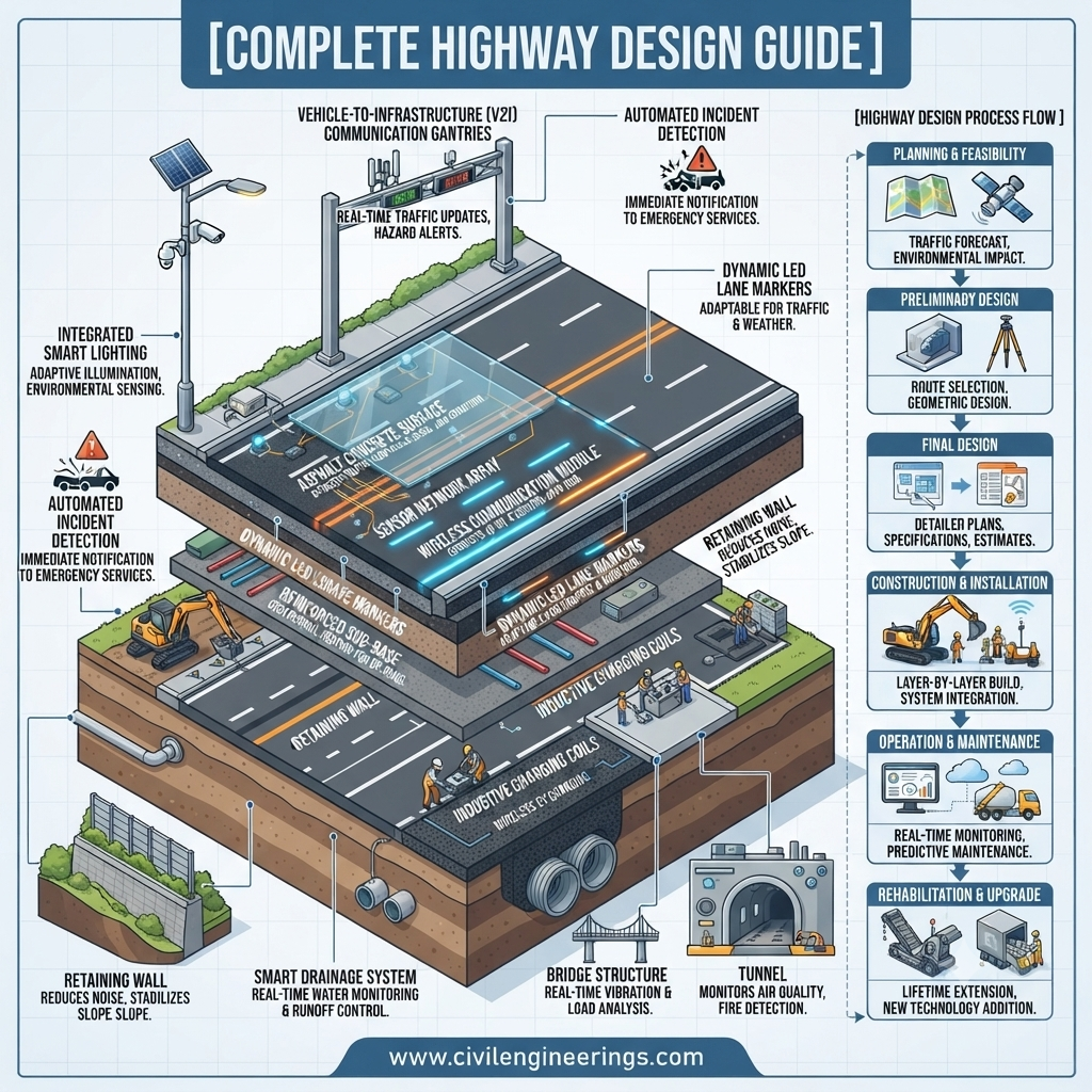
Complete Highway Design Process
A highway project generally follows these stages:
- Project Identification
- Feasibility Study
- Traffic Investigation
- Topographic Survey
- Geotechnical Investigation
- Environmental Assessment
- Route Selection
- Geometric Design
- Pavement Design
- Drainage Design
- Structural Design
- Utility Coordination
- Road Safety Audit
- Cost Estimation
- Preparation of Construction Drawings
- Tender Documentation
Each stage contributes to a safe, functional, and cost-effective transportation facility.
Highway Planning and Feasibility Studies
Planning forms the foundation of every highway project. Engineers evaluate whether a proposed route is technically feasible, economically viable, and socially beneficial.
Typical studies include:
- Existing road network analysis
- Population growth assessment
- Land use evaluation
- Economic analysis
- Environmental screening
- Preliminary cost estimation
- Risk assessment
Feasibility studies help decision-makers determine whether the project should proceed.
Traffic Surveys and Forecasting
Traffic data directly influences highway capacity and geometric design.
Common traffic surveys include:
- Traffic volume count
- Origin–destination survey
- Speed study
- Axle load survey
- Vehicle classification survey
- Accident analysis
- Turning movement counts
Traffic forecasting estimates future demand over a design period, commonly 20–30 years.
Key Factors
- Population growth
- Economic development
- Industrial expansion
- Tourism
- Urbanisation
- Freight movement
Route Selection and Alignment
Selecting the best route balances engineering requirements with economic, environmental, and social considerations.
Factors Affecting Route Selection
- Terrain
- Soil conditions
- Rivers
- Existing infrastructure
- Forests
- Agricultural land
- Urban development
- Cultural heritage sites
Types of Alignment
- Horizontal Alignment
- Vertical Alignment
- Combined Alignment
Proper alignment reduces earthwork, improves visibility, and enhances safety.
Geometric Highway Design
Geometric design determines how drivers interact with the roadway.
Major design elements include:
Design Speed
The selected speed influences nearly every geometric feature, including curves, sight distance, lane width, and superelevation.
Lane Width
Typical values:
- Urban roads: 3.25–3.5 m
- Highways: 3.5–3.75 m
Cross Section
Includes:
- Carriageway
- Shoulders
- Median
- Side slopes
- Drainage channels
Horizontal Curves
Designed to ensure safe vehicle movement using:
- Radius
- Transition curves
- Superelevation
Vertical Curves
Used to provide:
- Smooth riding quality
- Adequate stopping sight distance
- Comfortable vehicle operation
Sight Distance
Important types include:
- Stopping Sight Distance (SSD)
- Overtaking Sight Distance (OSD)
- Decision Sight Distance (DSD)
Pavement Design
Pavement design determines the structural capacity required to support traffic loads throughout the design life.
Types of Pavement
Flexible Pavement
Layers include:
- Surface Course
- Binder Course
- Base Course
- Sub-base
- Subgrade
Advantages:
- Lower initial cost
- Easier maintenance
- Faster construction
Rigid Pavement
Constructed using Portland cement concrete.
Advantages:
- Longer lifespan
- Lower maintenance
- Better heavy-load performance
Factors Affecting Pavement Design
- Traffic loading
- Soil strength
- Climate
- Drainage
- Material quality
- Construction quality
- Design life
Highway Drainage Design
Water is one of the biggest threats to pavement performance.
Effective drainage protects:
- Pavement layers
- Embankments
- Bridges
- Culverts
- Slopes
Drainage systems include:
- Side drains
- Cross drains
- Culverts
- Catch basins
- Stormwater channels
- Longitudinal drains
Good drainage significantly increases pavement life.
Highway Structures
Many highway projects include structural components.
Examples include:
- Bridges
- Flyovers
- Underpasses
- Culverts
- Retaining walls
- Box culverts
- Pedestrian bridges
Structural design considers:
- Dead loads
- Live loads
- Seismic loads
- Wind loads
- Hydraulic forces
Road Safety Engineering
Modern highway design prioritises user safety.
Important safety features include:
- Road signs
- Pavement markings
- Crash barriers
- Median barriers
- Reflective studs
- Guardrails
- Lighting
- Pedestrian crossings
- Bicycle facilities
- Traffic signals
Road Safety Audits (RSA) identify hazards before construction and after project completion.
Environmental Considerations
Sustainable highway development reduces long-term environmental impacts.
Engineers assess:
- Air quality
- Noise pollution
- Wildlife habitats
- Water resources
- Soil erosion
- Carbon emissions
- Vegetation loss
Mitigation measures include:
- Wildlife crossings
- Noise barriers
- Rainwater harvesting
- Slope stabilisation
- Tree plantation
- Sustainable drainage systems
Utility Coordination and Right-of-Way
Existing utilities often require relocation before construction.
Common utilities include:
- Water supply lines
- Gas pipelines
- Electricity cables
- Fibre optic networks
- Sewer systems
Right-of-Way (ROW) acquisition involves legal, technical, and administrative procedures to secure the land required for the highway corridor.
Design Standards and Guidelines
Highway engineers rely on recognised standards to ensure consistency, safety, and performance.
Common references include:
IRC (Indian Roads Congress)
Provides guidelines for:
- Geometric design
- Pavement design
- Road safety
- Traffic engineering
AASHTO
The American Association of State Highway and Transportation Officials publishes widely adopted guidance on geometric design, pavement structures, bridge design, and transportation planning.
ICE
The Institution of Civil Engineers promotes best practices in infrastructure planning, sustainability, and professional engineering standards.
While local regulations always take precedence, these organisations provide valuable technical references for engineers worldwide.
Digital Tools Used in Highway Design
Modern projects increasingly depend on specialised software to improve accuracy and collaboration.
Common tools include:
- AutoCAD Civil 3D
- Bentley OpenRoads Designer
- MX Road
- InfraWorks
- ArcGIS
- Autodesk ReCap
- OpenBridge Designer
- HEC-RAS
- HEC-HMS
- Primavera P6
- Microsoft Project
Building Information Modelling (BIM), drone surveys, LiDAR, and GIS integration further enhance planning, design, and asset management.
Simplified Highway Design Workflow
Need Identification
        │
Feasibility Study
        │
Traffic Survey
        │
Topographic & Geotechnical Investigation
        │
Route Selection
        │
Geometric Design
        │
Pavement Design
        │
Drainage & Structures Design
        │
Road Safety Audit
        │
Environmental Assessment
        │
Cost Estimate & BOQ
        │
Construction Drawings
        │
Tender & Construction
Best Practices for Highway Design
- Base decisions on reliable survey and traffic data.
- Conduct detailed geotechnical investigations before finalising the pavement structure.
- Design for future traffic growth rather than current demand alone.
- Prioritise safe alignments with adequate sight distance.
- Integrate efficient drainage into every stage of the design.
- Apply value engineering to optimise cost without compromising quality.
- Incorporate climate resilience and sustainable materials where practical.
- Perform independent design reviews and road safety audits.
- Ensure compliance with applicable national standards and project specifications.
Practical Recommendations for
Engineers
- Update your knowledge of current design codes and software.
- Verify design assumptions using field investigations.
- Coordinate early with utility agencies and environmental authorities.
Contractors
- Follow approved drawings and specifications closely.
- Maintain strict quality control during earthwork, compaction, and paving.
- Document construction changes to support future maintenance.
Civil Engineering Students
- Strengthen your understanding of geometric design and pavement engineering.
- Gain practical experience with Civil 3D, OpenRoads, or similar software.
- Study real-world highway projects to understand how engineering decisions affect construction and operation.
Frequently Asked Questions (FAQs)
1. What is highway design?
Highway design is the engineering process of planning, analysing, and developing safe, durable, and efficient roads based on traffic, terrain, environmental conditions, and engineering standards.
2. What are the main stages of highway design?
The principal stages include planning, surveys, route selection, geometric design, pavement design, drainage, structural design, safety assessment, environmental evaluation, and construction documentation.
3. Why is traffic forecasting important?
Traffic forecasting estimates future vehicle demand, enabling engineers to design highways with sufficient capacity and structural strength throughout the intended design life.
4. What is the difference between flexible and rigid pavement?
Flexible pavements use asphalt layers and distribute loads gradually, whereas rigid pavements use concrete slabs with higher stiffness and generally require less maintenance over long service periods.
5. Which software is commonly used for highway design?
Widely used software includes AutoCAD Civil 3D, Bentley OpenRoads Designer, InfraWorks, ArcGIS, HEC-RAS, and Primavera P6.
6. What is a Road Safety Audit?
A Road Safety Audit is an independent assessment that identifies potential safety risks and recommends improvements before or after construction.
7. How does drainage affect highway performance?
Proper drainage prevents water infiltration, protects pavement layers, reduces erosion, and significantly extends the service life of the roadway.
8. Which standards are commonly followed in highway design?
Engineers commonly refer to national highway standards along with internationally recognised guidance such as IRC, AASHTO, and ICE publications, depending on project requirements.
9. Why are geotechnical investigations necessary?
They determine soil properties, bearing capacity, groundwater conditions, and settlement risks, all of which influence pavement and foundation design.
10. What skills should a highway design engineer develop?
A successful highway engineer should understand surveying, transportation engineering, pavement design, hydrology, CAD/BIM software, project management, and applicable design standards.
Conclusion
A successful highway project is the result of careful planning, sound engineering judgement, and adherence to proven design standards. From feasibility studies and traffic analysis to geometric design, pavement engineering, drainage systems, safety features, and environmental management, every stage contributes to the long-term performance of the transportation network. Modern highway design also benefits from advanced digital tools, data-driven decision-making, and sustainable engineering practices that improve efficiency while reducing life-cycle costs.
This Complete Highway Design Guide has outlined the essential principles, workflow, and best practices required to deliver safe, economical, and durable highways. Whether you are a student building foundational knowledge, a contractor executing fieldwork, or an experienced engineer managing complex infrastructure projects, understanding the complete design process leads to better technical decisions and higher-quality outcomes. By combining recognized guidance from organizations such as IRC, AASHTO, and ICE with local regulations and project-specific requirements, professionals can develop highways that serve communities effectively for decades while meeting the demands of future transportation.
