
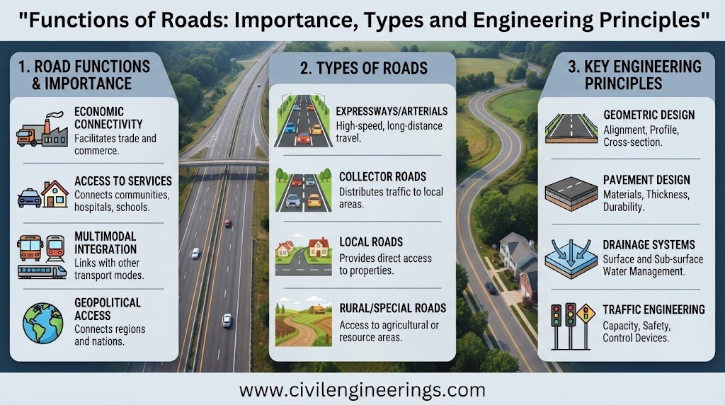
Roads are far more than paved surfaces connecting two points. They form the backbone of a transportation network, influence where communities grow, determine how quickly goods reach markets, and provide access to education, healthcare, employment, and essential services. A well-planned road can improve mobility while a poorly planned one can create congestion, safety risks, excessive maintenance costs, and inefficient land use.
The Functions of Roads therefore need to be understood before engineers decide how a road should be classified, designed, constructed, or managed.
From a highway engineering perspective, every road has a purpose. A local street primarily provides access to properties. A collector gathers traffic from local streets. An arterial emphasizes movement between important areas, while a freeway provides high-speed, controlled-access mobility. Modern road planning also recognizes that roads serve pedestrians, cyclists, public transport, freight, emergency services, and surrounding communities—not simply private vehicles. AASHTO’s current Green Book, for example, combines functional classification with context classification to support flexible, performance-based geometric design. (AASHTO Store)
This article explains the major functions of roads, how they influence road hierarchy and design, practical engineering applications, safety considerations, and recommendations for students, engineers, contractors, and infrastructure professionals.
What Are the Functions of Roads?
In simple terms, the functions of roads describe the purposes a road is expected to perform within a transportation system.
A road may provide:
- Movement of people
- Movement of goods
- Property and land-use access
- Connectivity between communities
- Economic and commercial support
- Emergency access
- Social interaction and public-space functions
- Support for public transportation
- Access for pedestrians and cyclists
- Strategic and regional connectivity
The important engineering principle is that not every road should perform every function at the same level.
A high-speed highway should prioritize efficient movement and controlled access. A residential street should emphasize safe access and low-speed interaction. Trying to make every road simultaneously maximize speed, property access, parking, pedestrian activity, freight movement, and social use usually creates conflicts.
PIARC describes mobility and access as fundamental road purposes and also identifies commercial and social interaction as an important function in many parts of the road network. (roadsafety.piarc.org)


Major Functions of Roads
1. Providing Mobility
Mobility is one of the most fundamental functions of a road.
A road allows people and vehicles to travel between origins and destinations. In highway engineering, mobility is particularly important on routes connecting cities, industrial areas, ports, airports, major commercial centers, and regional population centers.
For example, a motorway connecting two major cities should allow traffic to travel relatively efficiently with:
- Appropriate design speed
- Adequate lane capacity
- Limited access points
- Proper intersection control
- Suitable horizontal and vertical alignment
- Safe overtaking opportunities where applicable
Mobility is not simply about achieving the highest possible speed. Reliable travel time, predictable traffic operations, and safe movement are equally important.
2. Providing Accessibility
Accessibility refers to how easily people, properties, businesses, and communities can reach desired destinations.
A residential road may carry relatively little traffic, yet its accessibility function is extremely important. Residents need reliable access to homes, schools, markets, workplaces, healthcare facilities, and public transportation.
A useful distinction is:
Mobility = how efficiently traffic moves.
Accessibility = how easily destinations can be reached.
High-speed facilities tend to emphasize mobility, while local streets emphasize access. A balanced transportation network connects both functions through an appropriate road hierarchy.
3. Connecting Communities
Roads create physical connections between settlements.
A rural road may connect villages to a district center. A regional highway can connect districts to a major city. An interstate or national highway can connect major economic regions.
This connectivity can reduce isolation and improve access to:
- Education
- Healthcare
- Employment
- Agricultural markets
- Government services
- Commercial centers
- Industrial facilities
For developing communities, the construction of an all-weather road can be particularly significant because seasonal accessibility problems can restrict economic and social activity.
4. Supporting Economic Development
Road infrastructure has a direct relationship with economic activity.
Businesses depend on roads for receiving raw materials, transporting finished products, serving customers, and providing employee access. Farmers need roads to move agricultural products from production areas to collection points and markets.
Good road connectivity can reduce:
- Travel time
- Vehicle operating costs
- Freight delays
- Inventory uncertainty
- Product losses
- Logistics inefficiencies
For highway planners, this means that a road project should not be evaluated only by construction cost. Its broader transportation and economic effects also deserve consideration.
5. Facilitating Movement of Goods
Freight transportation is a major road function.
Trucks transport construction materials, agricultural products, manufactured goods, fuel, food, machinery, and countless other commodities. Freight-oriented corridors therefore require engineering decisions that differ from those for lightly trafficked residential streets.
Important considerations include:
- Heavy vehicle percentage
- Axle loading
- Pavement structural capacity
- Turning radii
- Vertical clearances
- Intersection geometry
- Climbing lanes where required
- Shoulder design
- Loading and unloading arrangements
- Bridge load capacity
Pavement design is particularly important because repeated heavy axle loads can produce significantly greater structural damage than ordinary passenger-car traffic.
6. Providing Property Access
Access is a dominant function of local roads.
A residential street must allow people to reach:
- Houses
- Apartment buildings
- Schools
- Shops
- Offices
- Hospitals
- Industrial properties
- Agricultural land
However, unrestricted access to an arterial or expressway can negatively affect safety and traffic flow.
For this reason, highway design often uses access management techniques such as:
- Median control
- Service roads
- Driveway spacing
- Turn restrictions
- Intersection consolidation
- Controlled access
- Grade separation
The objective is to provide necessary access without unnecessarily disrupting through traffic.
7. Supporting Public Transportation
Roads provide the physical platform for buses and other road-based public transport.
Urban corridors may need to accommodate:
- Bus lanes
- Bus stops
- Transit priority
- Passenger loading areas
- Pedestrian crossings
- Accessible sidewalks
- Interchange facilities
A road designed only around private vehicles may perform poorly as a transportation corridor if it ignores public transport demand.
Modern geometric design increasingly considers transportation of people rather than treating vehicle movement as the only objective. AASHTO’s Green Book explicitly reflects this broader approach. (AASHTO Store)
8. Providing Pedestrian and Cycling Connectivity
Roads are also part of the active transportation network.
Pedestrians and cyclists may use:
- Sidewalks
- Footpaths
- Shared-use paths
- Bicycle lanes
- Cycle tracks
- Pedestrian crossings
- Roadside trails
The appropriate treatment depends on traffic speed, traffic volume, land use, available right-of-way, and user demand.
On high-speed roads, vulnerable road users generally need greater physical separation from motor traffic. On low-speed urban streets, shared or mixed environments may sometimes be appropriate when the design deliberately controls vehicle speeds.
PIARC’s Safe System guidance emphasizes functional road hierarchy and design that responds to vulnerable road users and the surrounding context. (roadsafety.piarc.org)
9. Improving Road Safety
Safety is both a function and a fundamental performance requirement of modern roads.
A road should help users understand:
- Where they should travel
- How fast they should travel
- Where they can turn
- Where pedestrians can cross
- Where conflicts may occur
- What road conditions to expect
Engineering safety measures include:
- Adequate sight distance
- Appropriate lane widths
- Superelevation
- Clear road markings
- Traffic signs
- Guardrails where warranted
- Proper drainage
- Safe intersections
- Pedestrian facilities
- Lighting in appropriate locations
- Roadside hazard management
PIARC’s Safe System approach emphasizes embedding safety into planning and design rather than treating safety merely as a corrective measure after crashes occur. (roadsafety.piarc.org)
10. Supporting Emergency Services
Roads provide access for emergency vehicles such as:
- Ambulances
- Fire engines
- Police vehicles
- Disaster-response vehicles
- Rescue equipment
Emergency access becomes particularly important during floods, earthquakes, fires, major accidents, and other disasters.
Road geometry, bridge capacity, turning space, shoulder availability, and network redundancy can influence emergency response.
A transportation network with only one access route to an important community may have significant resilience limitations.
11. Supporting Commercial and Social Activities
Not every road exists primarily for movement.
Urban streets may function as commercial corridors, public spaces, pedestrian environments, and locations for social interaction.
A market street, for example, may need to accommodate:
- Pedestrians
- Shops
- Deliveries
- Parking
- Public transport
- Short-distance vehicle movement
- Street-side activities
PIARC recognizes commercial and social interaction as an important third human use of roads in addition to mobility and accessibility, particularly in many low- and middle-income settings. (roadsafety.piarc.org)
The engineering challenge is to manage these competing demands rather than assuming that higher vehicle speed always represents better road performance.
Functions of Roads and Functional Classification
Local Roads
Local roads primarily provide direct property access.
Typical characteristics include:
- Low to moderate traffic volumes
- Shorter trip lengths
- Frequent property access
- Lower operating speeds
- Limited through traffic
Examples include residential streets and minor rural access roads.
AASHTO recognizes local roads and streets as one of the traditional functional roadway classifications. (AASHTO Store)
Collector Roads
Collector roads gather traffic from local streets and transfer it toward arterial routes.
They perform a connecting role between:
Local access → Collector → Arterial → Major highway
Collectors generally carry more traffic than local streets but less than major arterials.
Their design must balance movement with access.
Arterial Roads
Arterial roads primarily support movement over larger areas.
They may connect:
- Major residential areas
- Commercial centers
- Industrial zones
- District headquarters
- Cities
- Major transport terminals
Access control becomes increasingly important because frequent driveways and uncontrolled intersections can reduce operational performance.
Freeways and Expressways
Freeways emphasize high-speed movement and controlled access.
Typical features include:
- Grade-separated intersections
- Controlled entry and exit
- Divided carriageways
- High design speeds
- Interchanges
- Limited direct property access
Their primary function is movement over relatively long distances with fewer interruptions.
AASHTO’s functional classification framework includes local roads and streets, collectors, arterials, and freeways. (AASHTO Store)
Relationship Between Road Function and Road Design
Design Speed
Road function strongly influences appropriate design speed.
Higher-speed roads generally require greater:
- Stopping sight distance
- Curve radius
- Clear zones
- Intersection control
- Access management
For a simple stopping sight distance concept:
SSD = 0.278 Vt + V²/(254f)
where:
- SSD = stopping sight distance in metres
- V = speed in km/h
- t = perception-reaction time in seconds
- f = coefficient of longitudinal friction
Actual design practice should use the applicable governing standard and design conditions rather than relying on a simplified equation alone.
Traffic Capacity
Road function also affects the required capacity.
A simplified traffic-flow relationship is:
q = k × v
where:
- q = traffic flow
- k = traffic density
- v = average speed
Engineers use traffic surveys, design-hour volumes, vehicle composition, growth forecasts, and operational analysis to determine appropriate lane requirements.
Access Control
The higher the movement function, the more carefully access normally needs to be controlled.
A local road may have numerous driveways.
An arterial may have controlled driveway spacing and signalized intersections.
A freeway generally restricts direct property access.
This progression protects the intended function of each road.
Functional Classification and Road Hierarchy
A functional road hierarchy prevents the entire network from becoming a collection of competing road segments.
A typical hierarchy can be represented as:
Local Roads → Collectors → Arterials → Expressways/Freeways
Each level performs a different combination of access and movement.
The hierarchy also helps engineers decide:
- Design speed
- Lane configuration
- Intersection spacing
- Access control
- Pedestrian treatment
- Parking policy
- Traffic management
- Pavement requirements
- Maintenance priorities
Modern approaches also recognize that functional classification should account for context. AASHTO’s current framework adds context classifications such as rural, rural town, suburban, urban, and urban core. (AASHTO Store)
Functions of Roads in Urban Areas
Urban roads often have multiple competing functions.
A single corridor may need to provide:
- Vehicle movement
- Bus movement
- Pedestrian access
- Cycling facilities
- Property access
- Parking
- Drainage
- Utility corridors
- Commercial frontage
- Public-space functions
This is why urban road design requires more than selecting a carriageway width.
The engineer must understand land use, traffic demand, pedestrian activity, public transport, safety, drainage, utilities, and future development.
In dense areas, a lower-speed street can sometimes provide better overall transportation performance than a vehicle-oriented corridor designed solely to maximize speed.
Functions of Roads in Rural Areas
Rural roads have different priorities.
Common functions include:
- Agricultural access
- Village connectivity
- Regional mobility
- Freight transportation
- Access to schools and healthcare
- Tourism and recreational travel
- Emergency connectivity
Agricultural roads require particular attention to seasonal conditions, drainage, farm access, slow-moving vehicles, and heavy agricultural equipment.
Poor drainage can rapidly damage rural pavement, especially where shoulders and roadside channels are inadequately maintained.
Road Function and Pavement Engineering
The expected function of a road affects pavement design because different road classes carry different traffic loads.
Important pavement inputs include:
- Design traffic
- Equivalent axle loading
- Subgrade strength
- Climate
- Drainage
- Material properties
- Reliability
- Design life
- Maintenance strategy
Flexible pavement may use asphalt-bound layers over granular base and subbase layers, while rigid pavement generally uses concrete slabs supported by appropriate foundation layers.
The pavement should be designed for the actual traffic and environmental conditions rather than simply according to road name.
A heavily loaded industrial collector, for example, may require a stronger pavement structure than a lightly trafficked local road even if both have similar geometric dimensions.
Road Functions and Drainage
Drainage is sometimes overlooked when discussing road functions, but it directly supports road performance.
Water can weaken pavement layers, erode shoulders, damage slopes, and contribute to premature deterioration.
A functioning road drainage system may include:
- Side drains
- Cross-drainage structures
- Culverts
- Catch basins
- Kerb and channel systems
- Subsurface drainage
- Outfalls
- Bridge drainage
The basic hydraulic relationship commonly used for open-channel considerations can be expressed through Manning’s equation:
Q = (1/n) A R^(2/3) S^(1/2)
where:
- Q = discharge
- n = Manning roughness coefficient
- A = flow area
- R = hydraulic radius
- S = channel slope
Actual drainage design requires appropriate hydrological analysis, rainfall data, catchment characteristics, and applicable standards.
How Road Functions Influence Road Safety
A mismatch between road function and physical design can create serious safety problems.
For example, consider a commercial street with:
- High pedestrian activity
- Numerous driveways
- Frequent roadside parking
- High traffic volume
- High vehicle speeds
If the road is designed like a high-speed arterial without adequate pedestrian protection, conflicts can increase.
PIARC highlights the value of clear functional hierarchy and “self-explaining” roads, where the road environment communicates expected behavior through consistent geometry, markings, speed environment, and other features. (roadsafety.piarc.org)
The goal is not simply to tell drivers to behave safely. The road itself should make appropriate behavior easier and more predictable.
Practical Example: Selecting the Function of a New Road
Suppose engineers need to connect a growing residential district to an existing national highway.
The first question should not be:
“How many lanes should we build?”
Instead, ask:
- What destinations does the road connect?
- How much traffic will it carry?
- What percentage will be through traffic?
- How many properties require direct access?
- Will buses operate on the corridor?
- Are pedestrians and cyclists present?
- What development is expected along the route?
- What level of access control is appropriate?
- What design speed matches the context?
- How will the road connect to the existing hierarchy?
The answers may indicate that the facility should function as a collector or arterial.
Only after establishing the intended function should engineers proceed confidently into detailed geometric, pavement, drainage, traffic, and safety design.
Best Practices for Designing Roads According to Their Function
For Civil Engineering Students
Students should learn to connect theory with network-level thinking.
Do not memorize local, collector, and arterial classifications as isolated definitions. Understand why their characteristics differ.
Focus on:
- Road hierarchy
- Traffic studies
- Geometric design
- Sight distance
- Pavement design
- Drainage
- Traffic engineering
- Road safety
- Transportation planning
When solving design problems, always begin by identifying the road’s intended function.
For Highway and Site Engineers
Engineers should verify the functional classification before finalizing geometry.
Review:
- Existing traffic patterns
- Future development
- Design traffic
- Land use
- Access requirements
- Pedestrian demand
- Public transport
- Freight movements
- Crash history
- Drainage conditions
- Utility constraints
A technically correct cross-section can still be inappropriate if it does not match the corridor’s actual function.
For Contractors
Contractors should understand that construction quality directly affects whether the intended road function can be achieved.
Pay close attention to:
- Formation preparation
- Compaction
- Layer thickness
- Material quality
- Drainage installation
- Kerb alignment
- Pavement tolerances
- Road markings
- Safety installations
- Construction traffic management
Do not treat drainage and roadside works as secondary items. They contribute directly to long-term road performance.
For Consultants and Government Engineers
Network-level planning should consider both present and future conditions.
A road may function adequately today but become overloaded after nearby development.
Therefore, planning should consider:
- Traffic growth
- Land-use changes
- Development control
- Future widening
- Public transport demand
- Freight growth
- Climate resilience
- Maintenance requirements
- Road safety performance
PIARC also emphasizes the importance of managing land use and access while distinguishing between different road environments and functions. (roadsafety.piarc.org)
IRC, AASHTO and ICE Guidance for Road Engineering
Different countries and agencies use different standards, so engineers should always identify the governing design framework before starting detailed work.
IRC
The Indian Roads Congress (IRC) provides a major body of guidance for road and highway engineering practice in India, covering areas such as geometric design, pavement engineering, traffic engineering, bridges, specifications, and road safety. Its official platform provides access to current organizational information and publications. (IRINN)
AASHTO
AASHTO’s A Policy on Geometric Design of Highways and Streets, commonly known as the Green Book, is a major reference for geometric highway and street design. Its framework includes traditional functional classifications and context classifications, supporting performance-based design decisions. (AASHTO Store)
ICE
The Institution of Civil Engineers (ICE) provides professional engineering knowledge, policy perspectives, and guidance relevant to infrastructure development. Its recent infrastructure work also emphasizes how transport infrastructure affects people’s access and everyday experience. (Institution of Civil Engineers (ICE))
Practical Standardization Principle
IRC, AASHTO, ICE publications, PIARC guidance, national highway manuals, and project specifications should not be mixed casually.
A project should establish:
Applicable standard → design criteria → functional classification → design controls → detailed engineering → verification
The governing contract documents and national regulations always take precedence where applicable.
Common Mistakes When Defining Road Functions
Several mistakes repeatedly appear in road planning.
Designing for Speed Instead of Function
Higher speed does not automatically mean a better road.
A road serving a busy pedestrian market may need lower operating speeds even when traffic demand is substantial.
Ignoring Future Development
Land development can transform a rural corridor into an urban commercial route.
Functional classification should therefore consider future land use where reliable planning information exists.
Providing Excessive Direct Access
Too many driveways and roadside connections can reduce arterial performance and increase conflict points.
Treating Vehicles as the Only Users
Pedestrians, cyclists, buses, motorcycles, freight vehicles, emergency services, and people with mobility limitations are all road users.
Neglecting the Roadside
Road function extends beyond the paved carriageway. Shoulders, drainage, sidewalks, clear zones, slopes, barriers, utilities, and roadside development all influence performance and safety.
Frequently Asked Questions About Functions of Roads
What are the main functions of roads?
The main functions include mobility, accessibility, connectivity, goods movement, property access, economic development, public transportation, pedestrian and cycling movement, emergency access, and social or commercial interaction.
Why are functions of roads important in highway engineering?
Road functions determine how engineers approach functional classification, design speed, access control, traffic capacity, intersections, pavement requirements, safety treatments, and roadside development.
What is the difference between mobility and accessibility?
Mobility concerns efficient movement between destinations, while accessibility concerns how easily people and goods can reach destinations. A well-designed transportation network needs both.
What is the function of a local road?
A local road mainly provides direct access to properties and neighborhoods. Through traffic generally receives less priority than accessibility.
What is the function of a collector road?
A collector gathers traffic from local roads and transfers it toward arterial routes. It provides a balance between access and movement.
What is the main function of an arterial road?
An arterial primarily provides relatively efficient movement between major areas while maintaining an appropriate level of access and intersection control.
Why is road hierarchy important?
Road hierarchy assigns different functions to different road classes. This reduces conflicts between high-speed movement and frequent property access and helps engineers develop a coordinated transportation network.
How do road functions affect pavement design?
Road function influences expected traffic volume, heavy-vehicle percentage, axle loading, design life, and therefore the required pavement structure.
Do roads have social functions?
Yes. Urban and community roads can support social interaction, commercial activity, walking, public transport, and public-space functions in addition to vehicle movement. (roadsafety.piarc.org)
Which standards should engineers use for road design?
Engineers should use the standards specified by the relevant jurisdiction, client, contract, and project authority. IRC, AASHTO, PIARC, ICE resources, national highway manuals, and other recognized standards can provide valuable engineering guidance, but the governing project requirements should always be confirmed first.
Conclusion
The Functions of Roads provide the foundation for understanding how an effective transportation network should operate. Roads are not simply structures built to carry vehicles. They connect communities, support economic activity, provide property access, move freight, enable public transportation, facilitate walking and cycling, support emergency response, and influence the safety and development of surrounding areas.
From an engineering standpoint, the most important principle is to match road function with road design. Local roads should not be expected to perform like freeways, and high-speed arterials should not be overloaded with unrestricted property access. Functional classification, road hierarchy, traffic demand, land use, safety, drainage, pavement requirements, and future development must work together.
A successful road is therefore not merely one that has been constructed correctly. It is one that performs the function for which it was planned—safely, efficiently, reliably, and sustainably throughout its service life.
