
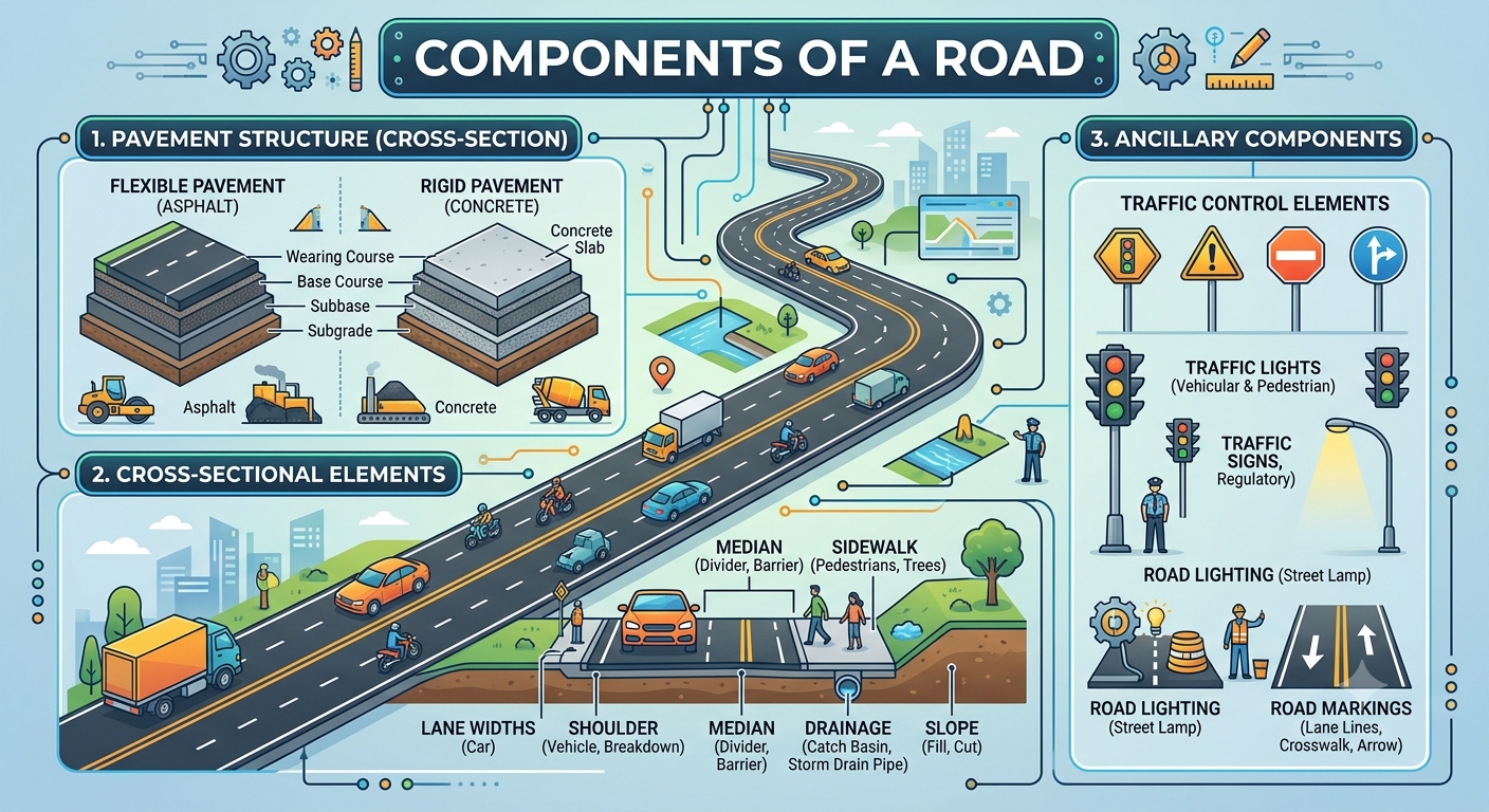
A road may appear to be nothing more than a paved surface, but a properly engineered roadway is a carefully integrated system. Beneath the visible surface are several pavement layers, while shoulders, drainage facilities, slopes, medians, traffic-control devices, and safety features work together to create a functional transportation facility.
Understanding the Components of a Road is essential for civil engineering students, highway engineers, site engineers, contractors, consultants, and infrastructure professionals. Each component has a specific purpose. A weak subgrade can damage the pavement above it, while inadequate drainage can reduce pavement life even when the pavement materials meet the required specifications.
This article provides a practical and engineering-focused explanation of the major components of a road. It covers pavement layers, carriageways, shoulders, medians, kerbs, drainage systems, road formation, geometric elements, roadside facilities, traffic signs, safety barriers, pedestrian infrastructure, and utilities. It also explains important engineering principles, basic formulas, construction considerations, common mistakes, and practical recommendations for professionals working on road projects.
What Are the Components of a Road?
The Components of a Road are the structural, geometric, drainage, safety, and operational elements that collectively make a roadway suitable for traffic.
A typical road may contain:
- Right of way
- Road formation
- Carriageway
- Traffic lanes
- Shoulders
- Median
- Pavement layers
- Subgrade
- Side slopes
- Drainage facilities
- Kerbs and gutters
- Road markings
- Traffic signs
- Safety barriers
- Footpaths and cycle facilities
- Culverts and cross-drainage structures
- Roadside facilities
- Utility corridors
The exact arrangement depends on whether the facility is a local road, collector road, arterial road, rural highway, urban street, expressway, or another road classification.
A road cross-section provides a useful way to understand how these elements fit together. It can show pavement thickness, carriageway width, shoulder arrangement, crossfall, drainage, embankment slopes, and surrounding ground conditions.


The Federal Highway Administration describes a pavement system as a combination of surface, base, and subbase layers placed over the subgrade to support traffic and distribute loads. Drainage features may also be incorporated to remove water from the pavement structure. (Federal Highway Administration)
Pavement Structure
The pavement structure is one of the most important components of a road. Its primary function is to provide a durable and relatively smooth riding surface while distributing traffic loads over the underlying soil.
The arrangement differs between flexible and rigid pavement.
Subgrade
The subgrade is the prepared upper portion of the natural soil or improved soil that supports the pavement structure.
It is essentially the foundation of the pavement.
Important subgrade properties include:
- Soil classification
- CBR
- Moisture content
- Dry density
- Compaction
- Shear strength
- Stiffness
- Drainage characteristics
- Swelling and shrinkage potential
A weak or highly variable subgrade may require improvement before pavement construction.
Possible treatments include:
- Soil replacement
- Mechanical stabilization
- Lime stabilization
- Cement stabilization
- Geosynthetic reinforcement
- Improved drainage
A common mistake is to focus heavily on pavement thickness while ignoring the condition of the supporting soil.
Sub-Base Course
The sub-base normally lies directly above the subgrade.
Its functions can include:
- Load distribution
- Drainage
- Protection of the subgrade
- Reduction of pumping or deformation
- Providing a construction platform
- Separation between fine subgrade soil and granular layers
Typical materials include graded granular material, crushed aggregate, recycled materials, or stabilized materials.
Base Course
The base course provides significant structural support beneath the surface layer.
Common base materials include:
- Crushed stone
- Crushed gravel
- Wet-mix aggregate
- Mechanically stabilized aggregate
- Cement-treated materials
- Other approved engineered mixtures
Quality control is particularly important at this level because defects in the base can eventually appear as pavement distress.
One useful quality-control calculation is:
Degree of Compaction (%) = Field Dry Density / Maximum Dry Density × 100
For example, if the field dry density is 1.95 Mg/m³ and the laboratory maximum dry density is 2.05 Mg/m³:
Degree of Compaction = 1.95 / 2.05 × 100 = 95.1%
The required percentage should always come from the project’s approved specification.
Surface or Wearing Course
The wearing course is the layer directly exposed to traffic and weather.
For flexible pavement, it commonly consists of an asphalt or bituminous mixture. For rigid pavement, the concrete slab serves as the primary traffic-bearing surface.
A good surface should provide:
- Skid resistance
- Smoothness
- Durability
- Adequate texture
- Resistance to abrasion
- Protection against water infiltration
Typical surface-related failures include ravelling, bleeding, potholes, cracking, rutting, and loss of texture.
Carriageway and Traffic Lanes
The carriageway is the part of the roadway primarily intended for vehicle movement.
It may consist of one or several lanes depending on traffic demand and road classification.
Traffic Lanes
Traffic-lane dimensions depend on:
- Design speed
- Traffic volume
- Vehicle dimensions
- Heavy-vehicle percentage
- Road classification
- Terrain
- Safety requirements
- Applicable design standards
A highway carrying large volumes of heavy vehicles generally requires different geometric and structural considerations from a low-volume local road.
Carriageway Width
For a simple two-lane road:
Carriageway Width = 2 × Lane Width
For example, if each lane is 3.5 m wide:
Carriageway Width = 2 × 3.5 = 7.0 m
This is only a basic calculation. Actual lane widths should be selected using the governing road-design standard and project requirements.
Crown and Crossfall
The pavement surface normally incorporates a cross slope so rainwater can move toward the road edges.
A basic relationship is:
Crossfall (%) = Vertical Difference / Horizontal Distance × 100
If the elevation difference is 70 mm across 3.5 m:
Crossfall = 0.07 / 3.5 × 100 = 2%
The required crossfall varies with pavement type, climate, surface characteristics, road classification, and applicable standards.
Road Shoulders
Shoulders are located immediately outside the traffic lanes.
They provide several important functions:
- Emergency stopping space
- Lateral pavement support
- Vehicle recovery area
- Maintenance space
- Additional separation from roadside hazards
- Support for pavement edges
Paved Shoulders
Paved shoulders are particularly useful on higher-speed or heavily trafficked roads.
They allow disabled vehicles to move away from active traffic lanes and can reduce conflicts between stopped vehicles and moving traffic.
Unpaved Shoulders
Granular shoulders can be suitable for some lower-volume roads.
However, they require careful control of:
- Edge drop-off
- Drainage
- Erosion
- Compaction
- Material stability
A shoulder that is significantly lower than the pavement edge can become a safety problem.
Median and Central Separator
A median separates opposing traffic flows on divided roads.
Common forms include:
- Raised median
- Depressed median
- Concrete median
- Barrier median
- Landscaped median
- Flush median
The median can improve safety by reducing direct conflicts between opposing vehicles.
It may also accommodate:
- Lighting
- Drainage
- Signs
- Landscaping
- Barriers
- Turning facilities
Median openings should be carefully designed because each opening introduces potential vehicle conflict points.
Kerbs and Gutters
Kerbs are widely used on urban roads.
They can define the edge of the carriageway and separate vehicles from pedestrian or landscaping areas.
Kerbs may also work with gutters to collect and direct stormwater.
Functions of Kerbs
Major functions include:
- Edge definition
- Drainage control
- Sidewalk protection
- Traffic separation
- Parking organization
- Roadside appearance
Kerb design should consider vehicle turning movements, drainage, pedestrian accessibility, maintenance, and safety.
Road Drainage System
Drainage is among the most critical Components of a Road because water is one of the major causes of pavement deterioration.
Road drainage systems may include:
- Side drains
- Catch drains
- Gutters
- Kerb inlets
- Catch basins
- Culverts
- Cross-drainage structures
- Subsurface drains
- Edge drains
- Drainage outlets
- Erosion protection


A road drainage arrangement may need to remove both surface water and infiltrated subsurface water. FHWA guidance specifically identifies drainage layers, edge drains, outlets, and filter materials as possible components of pavement drainage systems. (Federal Highway Administration)
Surface Drainage
Surface drainage removes rainfall from the pavement.
The pavement crossfall directs water toward the edge, where it enters a gutter, drain, ditch, or other collection facility.
Poor surface drainage can cause:
- Ponding
- Skidding
- Water infiltration
- Edge deterioration
- Surface cracking
Subsurface Drainage
Subsurface drainage removes water that enters or accumulates beneath the pavement.
Possible components include:
- Perforated pipes
- Drainage layers
- Filter materials
- Geotextiles
- Edge drains
- Collector drains
The drainage system must be designed so that collected water can actually leave the pavement structure.
Side Drains
Side drains collect water from the roadway and adjacent land.
They may be:
- Earthen
- Concrete-lined
- Stone-lined
- Trapezoidal
- V-shaped
- Rectangular
The choice depends on flow, erosion risk, terrain, available space, soil conditions, and maintenance requirements.
Culverts
Culverts allow water to pass beneath the roadway.
They may use:
- Reinforced concrete pipes
- Box culverts
- Corrugated structures
- Multiple-cell arrangements
Hydraulic design should consider catchment area, rainfall, runoff, inlet conditions, outlet conditions, debris, erosion, and downstream effects.
Road Formation and Earthwork
The road formation is the prepared platform on which the pavement and related road elements are constructed.
Road earthwork commonly involves:
- Excavation
- Embankment
- Filling
- Grading
- Compaction
- Soil improvement
- Slope formation
Cut Sections
A cut section occurs where the proposed road level is below the existing ground.
Cut slopes must be designed according to:
- Soil type
- Rock conditions
- Groundwater
- Slope height
- Stability
- Drainage
Fill Sections
A fill section occurs where material is placed to raise the roadway above existing ground.
Embankment construction should be performed in controlled layers with appropriate moisture and compaction.
Slope Protection
Road embankments and cut slopes may require protection against erosion.
Common methods include:
- Grass vegetation
- Stone pitching
- Riprap
- Concrete lining
- Gabions
- Erosion-control mats
- Drainage channels
Horizontal and Vertical Alignment
Road geometry controls how vehicles move along the highway.
Horizontal Alignment
Horizontal alignment includes:
- Tangents
- Circular curves
- Transition curves
- Intersections
- Superelevation
Curve design must consider speed, radius, friction, sight distance, and vehicle dynamics.
A commonly used basic relationship is:
e + f = V² / 127R
Where:
- e = superelevation rate
- f = side-friction factor
- V = speed in km/h
- R = curve radius in metres
Actual design limits should come from the applicable standard.
Vertical Alignment
Vertical alignment consists mainly of grades and vertical curves.
It influences:
- Sight distance
- Drainage
- Earthwork
- Heavy-vehicle operation
- Driver comfort
- Fuel consumption
Summit curves require particular attention to sight distance, while sag curves require consideration of drainage, lighting, and headlight visibility.
Roadside Elements and Safety Features
A roadway does not end at the pavement edge.
The roadside environment also contributes significantly to safety.
Important elements include:
- Clear zones
- Guardrails
- Safety barriers
- Delineator posts
- Signs
- Lighting
- Roadside drainage
- Utility protection
- Landscaping
- Maintenance areas
Fixed roadside hazards should be evaluated during design. Where hazards cannot reasonably be removed or relocated, appropriate protection may be considered.
Traffic Signs and Road Markings
Traffic-control devices provide information and guidance to road users.
Traffic Signs
Road signs generally communicate:
- Regulations
- Warnings
- Directions
- Destinations
- Services
- Temporary work-zone instructions
Signs should be positioned so drivers have sufficient time to see, understand, and respond to the information.
Pavement Markings
Road markings organize traffic and improve road-user understanding.
Typical markings include:
- Center lines
- Lane lines
- Edge lines
- Stop lines
- Direction arrows
- Pedestrian crossings
- Turn markings
- Parking markings
- Hazard markings
Marking visibility can deteriorate because of traffic wear, weather, dirt, and poor material selection. Maintenance is therefore part of the overall road-management strategy.
Pedestrian and Bicycle Facilities
Roads increasingly need to accommodate pedestrians and cyclists in addition to motor vehicles.
Urban projects may include:
- Footpaths
- Sidewalks
- Cycle lanes
- Shared-use paths
- Pedestrian crossings
- Refuge islands
- Accessible ramps
- Bus stops
Continuity is particularly important.
A sidewalk that suddenly ends at a drainage structure or intersection does not provide a complete pedestrian route. Designers should consider accessibility, crossing distance, visibility, vehicle turning movements, and separation from traffic.
Utilities and Roadside Services
Urban roads frequently contain underground and above-ground utilities.
These may include:
- Water pipelines
- Sewer systems
- Gas lines
- Electrical cables
- Telecommunications
- Street lighting
- Drainage networks
Utility coordination should occur during the design stage.
Unexpected utility conflicts during construction can result in:
- Project delays
- Additional costs
- Traffic disruption
- Design changes
- Safety risks
Survey information, utility records, trial pits, and appropriate detection technologies can help identify conflicts before excavation.
Bridges, Culverts, and Retaining Structures
Road projects often include structures that support or protect the roadway.
Examples include:
- Bridges
- Box culverts
- Pipe culverts
- Retaining walls
- Underpasses
- Overpasses
- Approach slabs
Bridge Approaches
Bridge approaches require careful attention because differential settlement can create bumps at the transition between roadway and structure.
Proper embankment construction, drainage, compaction, and transition detailing can reduce this problem.
Retaining Walls
Retaining structures may be required where the available right of way is limited or where steep terrain prevents conventional slopes.
Design must consider:
- Earth pressure
- Groundwater
- Foundation conditions
- Drainage
- Surcharge
- Structural stability
Right of Way and Road Reserve
The right of way, commonly called ROW, represents the land corridor reserved or acquired for the transportation facility.
It can accommodate:
- Carriageway
- Shoulders
- Median
- Drainage
- Slopes
- Utilities
- Footpaths
- Safety areas
- Future improvements
A sufficient ROW can provide flexibility for future widening, drainage upgrades, pedestrian improvements, and utility requirements.
Important Engineering Principles for Road Components
Design the Road as an Integrated System
The components should never be designed independently without considering their interaction.
For example, increasing pavement width may affect:
- Drainage
- Earthwork
- ROW
- Utility locations
- Cost
- Pedestrian facilities
Likewise, changing the vertical alignment can affect both drainage and earthwork quantities.
Give Drainage High Priority
Water should be controlled from the beginning of design through construction and maintenance.
Engineers should verify:
- Pavement crossfall
- Shoulder crossfall
- Side-drain gradients
- Culvert locations
- Drainage outlets
- Subsurface drainage
- Embankment protection
- Natural watercourses
Verify Layer Thickness and Levels
Survey and quality-control teams should verify:
- Formation levels
- Pavement width
- Layer thickness
- Crossfall
- Compaction
- Material quality
- Finished levels
A small error repeated across a long highway can become a major quantity and performance issue.
Practical Recommendations for Students, Engineers, and Contractors
For Civil Engineering Students
Students should learn to visualize a road in cross-section.
Instead of memorizing the names of pavement layers, understand what each layer does and why it is required.
Practice drawing:
- Flexible pavement sections
- Rigid pavement sections
- Road cross-sections
- Cut sections
- Fill sections
- Side-drain arrangements
- Median arrangements
Students should also learn basic pavement, surveying, highway geometric-design, soil-mechanics, and drainage concepts.
For Highway and Site Engineers
Site engineers should compare the approved drawings with actual field conditions.
Particular attention should be given to:
- Subgrade condition
- Pavement thickness
- Compaction
- Drainage
- Crossfall
- Material quality
- Levels
- Road width
- Utility conflicts
- Construction tolerances
Do not wait until the final inspection to discover problems hidden beneath completed pavement.
For Contractors
Contractors should establish a project-specific quality-control plan before major pavement activities begin.
Good practice includes:
- Approved material sources
- Trial sections
- Calibrated equipment
- Layer-by-layer inspection
- Density testing
- Survey verification
- Moisture control
- Drainage inspection
- Proper construction records
Documentation is especially important on major infrastructure projects because it provides evidence of compliance and helps future maintenance teams understand how the facility was constructed.
IRC, AASHTO, and ICE References in Road Engineering
Road design should always follow the standards adopted by the relevant road authority.
The Indian Roads Congress (IRC) publishes standards and guidelines covering numerous areas of highway engineering, including geometric design, pavement engineering, traffic facilities, and road infrastructure.
AASHTO publications are widely used in the United States and are also referenced internationally for transportation engineering. Its geometric-design guidance addresses highway and street design while allowing engineers to consider functional and contextual characteristics.
The Institution of Civil Engineers (ICE) provides professional resources and technical guidance related to transportation infrastructure, highway development, engineering practice, and infrastructure management.
These organizations should be used as professional references rather than as substitutes for project-specific requirements. The governing authority, contract documents, approved drawings, specifications, and applicable national standards should always control the final design and construction decisions.
Common Mistakes in Road Construction
Inadequate Drainage
Blocked drains, insufficient crossfall, poor outlets, and undersized culverts can allow water to damage the pavement system.
Poor Compaction
Insufficient compaction can result in:
- Settlement
- Rutting
- Cracking
- Loss of structural support
Incorrect Pavement Thickness
Constructing a layer thinner than specified can reduce the intended pavement capacity.
Weak Road Edges
Poorly constructed shoulders and unsupported pavement edges can lead to edge cracking and deterioration.
Ignoring Ground Conditions
Road alignment may pass through weak soils, groundwater, expansive materials, or variable geological formations. These conditions must be identified through appropriate investigation.
Poor Construction Sequencing
Drainage, utilities, earthworks, pavement, and roadside facilities must be coordinated.
A contractor may otherwise complete one activity only to remove or modify it during a later construction stage.
Frequently Asked Questions
What are the main components of a road?
The major components include pavement layers, subgrade, carriageway, traffic lanes, shoulders, median, drainage systems, road formation, side slopes, traffic signs, road markings, safety barriers, and pedestrian facilities where required.
What is the most important component of a road?
There is no single most important component. Road performance depends on the interaction between the pavement, subgrade, drainage, geometry, safety features, and construction quality.
What is the difference between pavement and carriageway?
The carriageway is the portion of the road intended primarily for vehicle movement. Pavement refers to the engineered structural layers supporting that movement.
Why is the subgrade important?
The subgrade provides the foundation for the pavement. Its strength, stiffness, moisture condition, and uniformity strongly influence pavement performance.
What is the purpose of a shoulder?
A shoulder provides lateral support, emergency stopping space, vehicle recovery space, and maintenance access.
Why is road drainage important?
Drainage prevents water from accumulating on or beneath the pavement. Excess water can reduce soil and pavement strength and accelerate deterioration.
What is the difference between flexible and rigid pavement?
Flexible pavement generally uses bituminous or asphalt surfacing over granular or stabilized layers. Rigid pavement primarily relies on a concrete slab for structural capacity.
What does crossfall mean in road construction?
Crossfall is the transverse slope provided across the roadway to help water move toward the drainage edge.
What should a site engineer inspect during pavement construction?
The site engineer should check material quality, layer thickness, moisture, compaction, levels, crossfall, width, surface quality, drainage, and compliance with approved drawings and specifications.
Can the components of a road vary?
Yes. Components vary according to road classification, traffic volume, design speed, terrain, climate, urban or rural setting, drainage requirements, available ROW, and applicable standards.
Conclusion
The Components of a Road work together as one engineered transportation system. The subgrade provides foundation support, while the sub-base and base distribute traffic loads. The surface course provides a safe and durable riding surface. Shoulders support the pavement edge and provide recovery space, while drainage facilities protect the entire structure from damaging water.
Road geometry is equally important. Horizontal and vertical alignment influence vehicle operation, sight distance, comfort, drainage, and safety. Medians, kerbs, traffic signs, markings, barriers, pedestrian facilities, utilities, culverts, and roadside elements complete the wider roadway system.
For civil engineering students, understanding these components provides a strong foundation in highway engineering. For engineers and consultants, proper coordination between structural, geometric, drainage, and safety elements is essential. Contractors must then convert the design into a durable facility through accurate levels, appropriate materials, controlled compaction, and effective quality assurance.
A successful road is therefore much more than a smooth asphalt surface. It is a carefully planned, constructed, drained, protected, and maintained infrastructure system designed to serve road users safely throughout its intended service life.

Kamran Malik is a passionate civil engineering writer and researcher who specializes in construction, transportation, structural engineering, and infrastructure topics. Through his articles on CivilEngineerings.com, he simplifies complex engineering concepts and shares practical insights, industry trends, and educational resources for students, professionals, and engineering enthusiasts.