
Introduction
Every successful road, highway, bridge, tunnel, airport, or building project begins with a thorough understanding of the ground beneath it. Engineers cannot rely on surface observations alone because soil and rock conditions often change significantly with depth. A detailed Borehole Investigation reveals these hidden conditions and provides the information required for safe and economical foundation design.
A borehole investigation forms one of the most important stages of a geotechnical site investigation. Civil engineers use boreholes to collect soil and rock samples, measure groundwater levels, and evaluate the engineering properties of subsurface materials. The collected data influences foundation selection, pavement design, slope stability, retaining structures, and earthwork planning.
Ignoring or shortening this investigation can lead to settlement, pavement failures, landslides, excessive construction costs, and structural damage. By contrast, a well-planned borehole investigation reduces uncertainty, improves design accuracy, and minimizes construction risks.
This guide explains the complete Borehole Investigation process, engineering principles, field methods, practical applications, and best practices used in modern road and highway engineering.
What is Borehole Investigation?
A Borehole Investigation is a geotechnical exploration method in which engineers drill one or more holes into the ground to study subsurface soil and rock conditions. The investigation helps determine the physical and engineering characteristics of the ground before construction begins.
Unlike surface inspections, boreholes provide direct information about underground layers, groundwater conditions, and material strength. Engineers use this information to design safe foundations, stable embankments, durable pavements, and effective drainage systems.
Information Obtained from a Borehole Investigation
A properly executed investigation provides valuable data, including:
- Soil stratification
- Rock depth and quality
- Groundwater table
- Soil strength
- Bearing capacity
- Compressibility
- Soil classification
- Engineering properties for design
These findings become the foundation of every geotechnical design report.
Why Borehole Investigation is Important
Every construction project depends on the strength of the supporting ground. Even a perfectly designed structure may fail if engineers misunderstand subsurface conditions.
A borehole investigation helps reduce uncertainty by revealing the actual ground profile rather than relying on assumptions.
Major Benefits
- Improves foundation design accuracy
- Identifies weak soil layers
- Detects groundwater conditions
- Reduces construction risks
- Prevents excessive settlement
- Supports pavement design
- Minimizes project delays
- Optimizes construction costs
Practical Application
During highway construction, engineers often encounter alternating layers of clay, sand, and gravel. Without borehole data, pavement thickness may be underestimated, leading to premature rutting and cracking. Borehole investigations allow engineers to design pavement structures that match the site’s actual geotechnical conditions.
Objectives of Borehole Investigation
Every borehole investigation has clearly defined engineering objectives. These objectives ensure that the collected data meets the requirements of the proposed project.
Primary Objectives
- Determine subsurface soil profile.
- Measure groundwater depth.
- Evaluate bearing capacity.
- Locate rock strata.
- Assess foundation conditions.
- Identify problematic soils.
- Support pavement design.
- Estimate excavation requirements.
- Reduce construction uncertainties.
- Provide laboratory samples for testing.
The scope of the investigation depends on project size, soil variability, structural loads, and site complexity.
Engineering Principles Behind Borehole Investigation
Borehole investigations follow several fundamental geotechnical engineering principles.
Soil Stratification
Natural soils form in layers due to geological processes. Each layer possesses different engineering properties, such as density, strength, and permeability.
Engineers identify these layers through continuous drilling and sampling.
Load Transfer
Structures transfer loads to the ground through foundations. Borehole data helps engineers determine whether the soil can safely support these loads without excessive settlement.
Groundwater Influence
Groundwater significantly affects soil strength and stability. High groundwater levels may reduce bearing capacity, increase pore water pressure, and complicate excavation.
Monitoring groundwater during borehole investigations helps engineers develop appropriate drainage and dewatering strategies.
Soil Behavior
Different soils respond differently under loading:
- Clay compresses gradually.
- Sand provides immediate support but may liquefy under certain conditions.
- Gravel offers high bearing capacity and excellent drainage.
- Organic soils often possess low strength and high compressibility.
Understanding these behaviors allows engineers to select suitable foundation systems.
Types of Borehole Investigation
The choice of drilling method depends on soil conditions, investigation depth, project requirements, and available equipment.
1. Rotary Drilling
Rotary drilling uses a rotating drill bit to penetrate soil and rock formations.
Suitable For
- Deep boreholes
- Hard rock formations
- Highway projects
- Bridge foundations
- Large infrastructure developments
Advantages
- High drilling depth
- Fast penetration
- Continuous sampling
- Suitable for multiple soil conditions
2. Percussion Drilling
Percussion drilling breaks soil and rock using repeated hammering action.
Common Uses
- Hard formations
- Rock investigations
- Water well exploration
Although slower than rotary drilling, percussion drilling performs well in difficult geological conditions.
3. Auger Drilling
Auger drilling removes soil using helical blades attached to a rotating shaft.
Best Applications
- Soft clay
- Silt
- Loose sand
- Shallow investigations
Advantages
- Economical
- Quick setup
- Minimal disturbance
- Easy sampling
4. Wash Boring
Wash boring uses pressurized water to loosen soil while removing cuttings through the borehole.
This method is commonly used in soft soils where continuous sampling is not essential.
5. Core Drilling
Core drilling retrieves cylindrical rock samples known as cores.
These samples allow engineers to evaluate:
- Rock quality
- Fractures
- Weathering
- Strength
- Geological structures
Core drilling is indispensable for tunnels, bridges, dams, and mountainous highway projects.
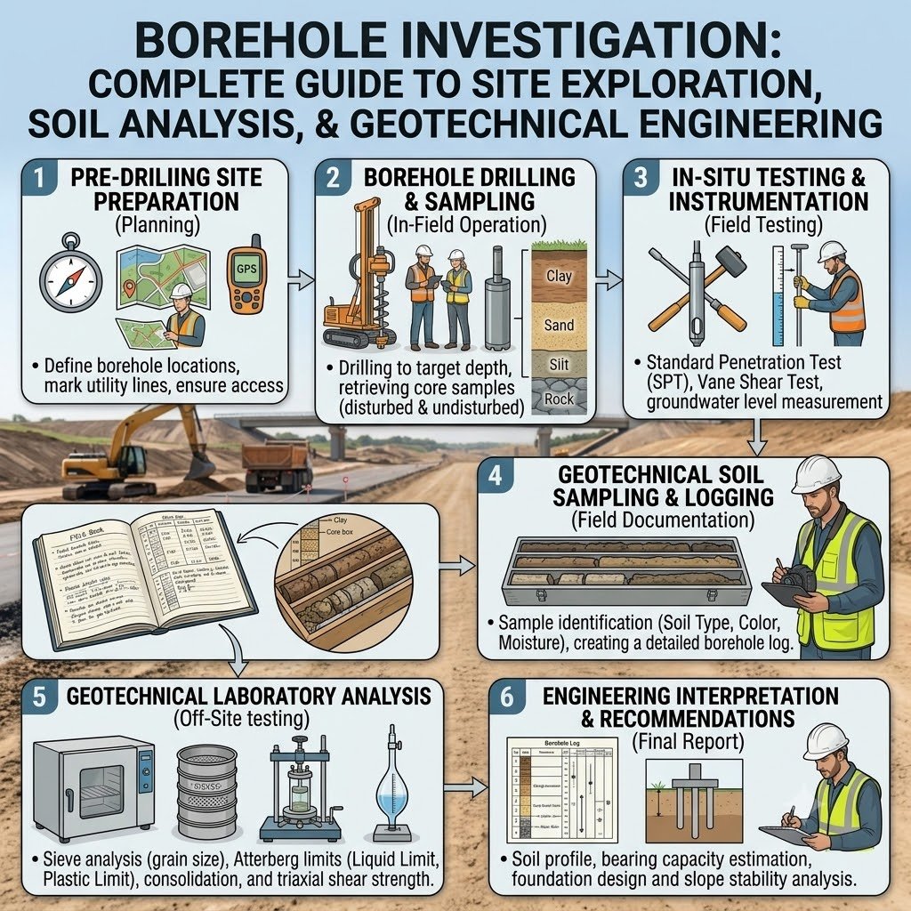
Borehole Investigation Process
Step 1: Site Planning
Engineers begin by reviewing available information, including:
- Topographic maps
- Geological maps
- Previous site investigations
- Project drawings
- Proposed structure locations
Careful planning determines the number, depth, and spacing of boreholes.
Step 2: Borehole Location Selection
Engineers position boreholes strategically to represent the entire project area.
Factors influencing borehole locations include:
- Foundation positions
- Bridge abutments
- Embankments
- Pavement alignment
- Cut and fill sections
- Retaining walls
Proper spacing improves the reliability of subsurface interpretation.
Step 3: Drilling Operations
The selected drilling method depends on the expected ground conditions.
During drilling, engineers continuously observe:
- Soil color
- Texture
- Moisture
- Density
- Rock fragments
- Groundwater inflow
These observations become part of the borehole log.
Step 4: Soil and Rock Sampling
Sampling provides materials for laboratory testing.
Types of Samples
Disturbed Samples
Used for:
- Soil classification
- Moisture content
- Grain size analysis
Undisturbed Samples
Used for:
- Shear strength
- Compressibility
- Consolidation
- Triaxial testing
Proper sampling preserves natural soil characteristics and improves laboratory accuracy.
Step 5: Groundwater Observation
Groundwater measurements play a critical role in foundation and pavement design.
Engineers record:
- Water table depth
- Seasonal fluctuations
- Artesian pressure (if present)
- Seepage conditions
These observations influence excavation methods, dewatering requirements, and drainage design.
Borehole Investigation Flow Diagram
Project Planning
        │
        ▼
Desk Study
        │
        ▼
Select Borehole Locations
        │
        ▼
Mobilize Drilling Equipment
        │
        ▼
Drilling Operations
        │
        ▼
Soil & Rock Sampling
        │
        ▼
Groundwater Observation
        │
        ▼
Laboratory Testing
        │
        ▼
Geotechnical Report
Practical Engineering Example
Consider the construction of a six-lane highway over an area with mixed soil conditions. Surface observations suggest firm ground, but a borehole investigation reveals alternating layers of soft clay and dense sand beneath the alignment. Laboratory testing shows that the clay has low bearing capacity and high compressibility. Based on these findings, engineers revise the pavement design, stabilize weak sections with lime treatment, and improve drainage to control groundwater. This proactive approach reduces the risk of differential settlement, extends pavement life, and lowers future maintenance costs.
Key Takeaways
A Borehole Investigation provides the essential geotechnical information needed before any major construction project begins. By identifying soil layers, rock formations, groundwater conditions, and engineering properties, it enables engineers to design safe, economical, and durable infrastructure. Careful planning, proper drilling techniques, accurate sampling, and systematic groundwater observation create the foundation for reliable design decisions and successful project execution.
Borehole Logging and Interpretation
After drilling and sampling, geotechnical engineers prepare a detailed borehole log. This document records all observations made during drilling and serves as one of the most valuable references for designers.
A borehole log presents the underground profile in a structured format, allowing engineers to understand changes in soil and rock conditions with depth.
Information Included in a Borehole Log
A standard borehole log typically contains:
- Borehole identification number
- Project name and location
- Borehole coordinates
- Ground elevation
- Drilling method
- Borehole depth
- Soil and rock descriptions
- Sample depths
- Standard Penetration Test (SPT) values
- Groundwater level
- Core recovery (for rock)
- Rock Quality Designation (RQD)
- Engineer’s observations
Importance of Borehole Logs
Accurate borehole logs help engineers:
- Select suitable foundation types.
- Estimate excavation requirements.
- Design pavement thickness.
- Identify weak soil zones.
- Plan slope stabilization.
- Evaluate groundwater conditions.
Poor documentation can result in incorrect design decisions and unnecessary construction risks.
Laboratory Testing of Borehole Samples
Field observations alone cannot provide all the engineering properties required for design. Engineers therefore send representative soil and rock samples to accredited laboratories for detailed testing.
Common Soil Tests
Grain Size Analysis
Determines the proportion of gravel, sand, silt, and clay within the soil.
Atterberg Limits
Measures the liquid limit, plastic limit, and plasticity index of fine-grained soils.
Moisture Content Test
Determines the natural water content of the soil.
Proctor Compaction Test
Establishes the optimum moisture content and maximum dry density for compaction.
California Bearing Ratio (CBR)
Evaluates the strength of subgrade soils for pavement design.
Triaxial Compression Test
Determines shear strength parameters under controlled loading conditions.
Consolidation Test
Measures settlement characteristics under sustained loads.
Common Rock Tests
- Unconfined Compressive Strength (UCS)
- Point Load Strength Test
- Slake Durability Test
- Density Test
- Water Absorption Test
These laboratory results provide the data required for safe and economical geotechnical design.
Equipment Used in Borehole Investigation
Modern borehole investigations rely on specialized drilling and testing equipment to improve accuracy and efficiency.
Drilling Equipment
- Rotary drilling rig
- Auger drilling machine
- Core drilling rig
- Percussion drilling rig
- Wash boring equipment
Sampling Equipment
- Split-spoon sampler
- Shelby tube sampler
- Core barrel
- Thin-wall sampler
Field Testing Equipment
- Standard Penetration Test (SPT) hammer
- Cone Penetration Testing (CPT) equipment
- Water level indicator
- Borehole camera (when required)
Support Equipment
- Water pump
- Compressor
- Generator
- Drilling rods
- Casing pipes
Proper maintenance and calibration of equipment improve the reliability of investigation results.
Common Challenges During Borehole Investigation
Although borehole investigations follow established procedures, engineers often encounter field challenges that require careful planning and experience.
Difficult Ground Conditions
Very hard rock, boulders, or fractured formations may slow drilling operations and increase equipment wear.
High Groundwater Levels
Excess groundwater can destabilize boreholes and complicate sampling.
Borehole Collapse
Loose sands and soft soils may collapse without proper casing support.
Limited Site Access
Remote, mountainous, or urban locations can restrict equipment movement.
Sample Disturbance
Improper sampling techniques may alter natural soil properties, reducing laboratory accuracy.
Weather Conditions
Heavy rainfall and flooding may interrupt drilling activities and affect groundwater observations.
Experienced field engineers anticipate these challenges and develop practical solutions before mobilizing equipment.
Engineering Applications of Borehole Investigation
Borehole investigations support a wide range of civil engineering projects.
Highway Engineering
- Pavement design
- Embankment construction
- Cut slope stability
- Bridge approach design
Bridge Engineering
- Foundation design
- Pier construction
- Abutment stability
Building Construction
- Shallow foundation design
- Deep foundation design
- Basement excavation planning
Dam Engineering
- Seepage evaluation
- Rock foundation assessment
- Stability analysis
Tunnel Engineering
- Rock classification
- Fault identification
- Groundwater prediction
Airport Engineering
- Runway pavement design
- Taxiway construction
- Terminal foundation planning
Best Practices for Borehole Investigation
Successful geotechnical investigations depend on careful planning and strict quality control.
Recommended Best Practices
- Review geological maps before drilling.
- Select borehole locations strategically.
- Use appropriate drilling methods for site conditions.
- Collect representative disturbed and undisturbed samples.
- Record groundwater levels accurately.
- Maintain detailed borehole logs.
- Label and preserve samples properly.
- Conduct laboratory testing in accredited facilities.
- Verify field observations with laboratory results.
- Prepare a comprehensive geotechnical investigation report.
These practices improve the reliability of engineering recommendations and reduce construction risks.
Practical Recommendations
Civil Engineers
- Never finalize foundation or pavement designs without adequate borehole data.
- Compare borehole results with geological mapping.
- Review laboratory reports carefully before issuing design calculations.
- Coordinate closely with structural and highway engineers.
Contractors
- Protect borehole locations from construction traffic.
- Follow approved drilling procedures.
- Handle samples carefully during transportation.
- Report unexpected ground conditions immediately.
Engineering Students
- Learn how to interpret borehole logs.
- Understand the purpose of each laboratory test.
- Visit active drilling sites whenever possible.
- Practice reading geotechnical investigation reports.
Strong knowledge of borehole investigations enhances decision-making throughout the design and construction process.
General Discussion of IRC, AASHTO, and ICE Practices
Leading engineering organizations, including the Indian Roads Congress (IRC), the American Association of State Highway and Transportation Officials (AASHTO), and the Institution of Civil Engineers (ICE), recognize the importance of detailed geotechnical investigations before beginning major infrastructure projects.
Their guidance generally emphasizes:
- Conducting site investigations before design work starts.
- Selecting borehole depth according to project requirements and expected foundation loads.
- Performing representative field and laboratory testing.
- Considering groundwater conditions during design.
- Maintaining accurate borehole logs and documentation.
- Integrating geotechnical findings into pavement and foundation design.
- Applying quality assurance throughout the investigation process.
Following these accepted engineering principles improves safety, durability, and long-term performance of transportation infrastructure.
Frequently Asked Questions (FAQs)
1. What is a borehole investigation?
A borehole investigation is a geotechnical exploration method that involves drilling into the ground to collect soil and rock samples, measure groundwater levels, and evaluate subsurface conditions for engineering design.
2. Why is borehole investigation important before construction?
It helps engineers understand ground conditions, select suitable foundations, design pavements, estimate settlement, and reduce construction risks.
3. How deep should a borehole be?
The required depth depends on the type of project, foundation loads, geological conditions, and applicable engineering standards. Engineers determine the depth during the investigation planning stage.
4. What is the difference between disturbed and undisturbed soil samples?
Disturbed samples are suitable for classification and index tests, while undisturbed samples preserve the soil’s natural structure for strength and consolidation testing.
5. Which field test is most commonly performed during borehole drilling?
The Standard Penetration Test (SPT) is one of the most widely used field tests for evaluating soil density and strength.
6. How does groundwater affect foundation design?
Groundwater influences bearing capacity, excavation stability, drainage requirements, and long-term foundation performance. Engineers include groundwater observations in every investigation.
7. Which projects require borehole investigations?
Roads, highways, bridges, buildings, dams, airports, tunnels, retaining walls, and industrial facilities all benefit from detailed borehole investigations.
8. Can engineers skip borehole investigations for small projects?
Small structures may require less extensive investigations, but engineers should always assess site conditions before selecting a foundation. Skipping investigations increases the risk of unexpected ground problems.
9. What does an SPT value indicate?
The Standard Penetration Test (SPT) value provides an indication of soil density and relative strength, helping engineers evaluate foundation conditions.
10. Who prepares the final borehole investigation report?
A qualified geotechnical engineer compiles the report using field observations, laboratory results, borehole logs, and engineering analyses to support design decisions.
Conclusion
A Borehole Investigation forms the foundation of every successful civil engineering and road construction project. It provides essential information about soil layers, rock formations, groundwater conditions, and engineering properties that cannot be determined through surface inspections alone. By conducting systematic drilling, collecting representative samples, performing reliable laboratory testing, and preparing accurate borehole logs, engineers gain the knowledge needed to design safe, durable, and cost-effective foundations and pavements. A comprehensive Borehole Investigation also reduces construction risks, prevents costly design changes, and supports informed decision-making throughout the project lifecycle. Whether you are planning a highway, bridge, airport, dam, or commercial building, investing in a detailed geotechnical investigation improves structural performance and long-term reliability. Engineers, contractors, and students who understand borehole investigation techniques can confidently deliver projects that meet modern engineering standards while ensuring safety, quality, and sustainability.

Kamran Malik is a passionate civil engineering writer and researcher who specializes in construction, transportation, structural engineering, and infrastructure topics. Through his articles on CivilEngineerings.com, he simplifies complex engineering concepts and shares practical insights, industry trends, and educational resources for students, professionals, and engineering enthusiasts.